The ARCHAEOLOGIST - English Late-Medieval timber-framed ...
The ARCHAEOLOGIST - English Late-Medieval timber-framed ...
The ARCHAEOLOGIST - English Late-Medieval timber-framed ...

Create successful ePaper yourself
Turn your PDF publications into a flip-book with our unique Google optimized e-Paper software.
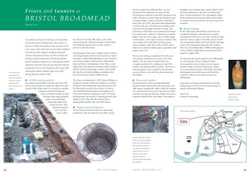
<strong>The</strong>se stone-built<br />
tanning pits are<br />
typical of industrial<br />
activity in the area<br />
adjacent to the<br />
Frome from the 17th<br />
century<br />
Friars and tanners at<br />
BRISTOL BROADMEAD<br />
Simon Cox<br />
Excavations will soon be coming to an end within<br />
the Bristol suburb of Broadmead. This work is in<br />
advance of major development and extension of the<br />
city’s main retail centre into an area where medieval<br />
town life saw fine religious buildings alongside<br />
noxious industrial processes. In later centuries the<br />
buildings and burial ground of Dominican friars<br />
passed to Quaker religious use, tanning and related<br />
industries persisted, and well documented medieval<br />
tenements can be traced through to their busy 20thcentury<br />
life, which included tragic loss of life<br />
during bombing raids in 1942.<br />
A 12th-century suburb<br />
<strong>The</strong> suburb was probably first laid out in the 12th<br />
century, just outside the medieval walled town and<br />
directly north of the castle. One trench lies outside a<br />
precinct wall of the Dominican<br />
Friary of Bristol, founded in 1227,<br />
the time when many religious<br />
orders were established<br />
around the edge of the<br />
medieval town. This<br />
trench includes the<br />
site of a public<br />
house called<br />
the Old Crown in the 19th century, part of the<br />
culverted branch of the River Frome or Back Ditch<br />
and buildings aligned on it, and the southern<br />
precinct wall of the Friary.<br />
<strong>The</strong> Dominican Friary had a double cloister, with two<br />
surviving elements which are now known as Cutler’s<br />
and Baker’s Halls. Both buildings have fine medieval<br />
roofs: that in Cutler’s Hall may be of 15th-century<br />
date, and Baker’s Hall perhaps of late 13th- or early<br />
14th-century date. Recent evaluation north of Cutler’s<br />
Hall by Oxford Archaeology revealed walls of both<br />
the church and cloister buildings, including what<br />
may have been part of the Chapter House.<br />
<strong>The</strong> Friary was dissolved in 1538. Dennis Hollister, a<br />
prominent member of the early Quaker movement<br />
in Bristol whose family had acquired the land, sold<br />
the Blackfriars precinct to the Society of Friends,<br />
who built their meeting house on foundations of<br />
some of the monastic buildings in 1670. <strong>The</strong> Friary<br />
burial ground was reused as a burial ground by the<br />
Quakers from 1700, with the meeting house<br />
subsequently rebuilt in the mid-18th century.<br />
Tanners and whittawers<br />
<strong>The</strong> earliest documentary references describing<br />
properties in this area date from the 14th century,<br />
and the suburb around Broad Weir was well<br />
developed when depicted on a map of 1568.<br />
Documentary evidence reveals that tenements were<br />
sold at this time to tanner Nicholas Wodhouse and<br />
to burgess Roger Cooke. By the time of Millerd’s<br />
map of the city (1673), the north side of Broad Weir<br />
was fully built up, with tenements stretching back<br />
from the street frontage to the River Frome. <strong>The</strong><br />
tenements on the Weare were subsequently bought<br />
by a tanner and a whittawer (whittawers prepared<br />
leather with salt, alum, eggs, lime etc make supple<br />
‘white leather’, ie its natural colour not tanned. This<br />
was usually done to the hides of sheep, goats,<br />
calves and pigs, rather than cattle, and the white<br />
leather was used for saddles, gloves, garments, shoe<br />
uppers, laces, etc).<br />
We are now starting to understand how the area<br />
was used for tanning from as early as the 15th<br />
century. <strong>The</strong> area closest to Broad Weir was<br />
occupied specifically by whittawers in the 17th<br />
century, and subsequently by tanners. <strong>The</strong> rears of<br />
these properties were occupied by the skinners’<br />
yards, and there were also lime pits, drying lofts<br />
and stables.<br />
Preserved <strong>timber</strong>s<br />
Excavations have so far revealed substantial<br />
medieval walls, defining the early tenements, and<br />
18th-century tanning pits within which the remains<br />
of wooden barrels can be seen. <strong>The</strong> pits were filled<br />
with lime and ground oak bark, which was used to<br />
transform animal hides into leather. <strong>The</strong> medieval<br />
buildings were founded upon organic debris which<br />
had been dumped into the river to reclaim land<br />
prior to initial settlement. <strong>The</strong> waterlogged nature<br />
of this material has ensured excellent preservation<br />
of artefacts and several <strong>timber</strong> structures have been<br />
recorded.<br />
Bomb damage<br />
By the 19th century Broad Weir street front was<br />
occupied by bakeries, eating houses and pubs,<br />
including the Old Crown, and many artefacts of this<br />
date have come to light. In the 20th century the site<br />
was occupied by <strong>timber</strong> yards and Taylors’ printing<br />
works. <strong>The</strong> buildings fronting this side of Broad<br />
Weir were demolished after a 500lb bomb tragically<br />
set fire to three double-decker buses packed with<br />
people in August 1942.<br />
An open day this March attracted over 1000 people<br />
on a freezing day. Those wishing to follow<br />
developments in more comfort can see regular<br />
updates on the Cotswold Archaeology website<br />
www.cotswoldarch.org.uk. Information about the<br />
development can also be found on Bristol City<br />
Council’s website, www.bristol-city.gov.uk/<br />
archaeology.<br />
Excavations are being undertaken by Cotswold<br />
Archaeology and Pre-Construct Archaeology on<br />
behalf of the Bristol Alliance.<br />
Simon Cox<br />
Cotswold Archaeology<br />
Plan of medieval Bristol<br />
19th-century Bristol<br />
stoneware flat<br />
bottle, for spirits<br />
An early (12th/13th century)<br />
<strong>timber</strong> construction platform<br />
found at the end of the dig.<br />
This extended out into the<br />
river channel, ostensibly to<br />
reclaim land on which to<br />
extend a tenement plot<br />
rearwards, and had<br />
substantial stone foundations<br />
built against it.<br />
32<br />
<strong>The</strong> Archaeologist<br />
Summer 2006 Number 60<br />
33