SHTV-2009-2013
SHTV-2009-2013
SHTV-2009-2013

You also want an ePaper? Increase the reach of your titles
YUMPU automatically turns print PDFs into web optimized ePapers that Google loves.
State Highway Traffic Data Booklet <strong>2013</strong><br />
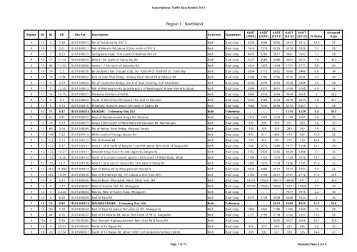
Region 1 - Northland<br />
Region SH RS RP Site Ref Description Direction Equipment<br />
AADT<br />
(<strong>2009</strong>)<br />
AADT<br />
(2010)<br />
AADT<br />
(2011)<br />
AADT<br />
(2012)<br />
AADT<br />
(<strong>2013</strong>) % Heavy<br />
Accepted<br />
Days<br />
1 10 0 7.38 ID:01000007 Sth of Puketona Rd (SH11) Both Dual Loop 4028 4008 3856 3852 3912 10.9 35<br />
1 10 7 3.01 ID:01000011 Nth of Wakelin Rd (about 3.5km north of SH11) Both Dual Loop 7414 7319 6630 6978 7030 7.3 38<br />
1 10 7 8.23 ID:01000015 Springbank Road, 1km south of Waimate Nth Rd Both Dual Loop 6076 6209 5617 5481 5697 7.3 38<br />
1 10 17 11.14 ID:01000029 About 1km south of Takou Bay Rd Both Dual Loop 3627 3580 3480 3403 3522 7.9 362<br />
1 10 48 11.93 ID:01000060 About 1.1 km north of Salvation Rd Both Dual Loop 1914 1874 1849 1791 1777 9.8 34<br />
1 10 79 2.2 ID:01000076 By Doubtless Bay Croquet Club, 50-100m W of Stratford Dr, Cable Bay Both Dual Loop 3854 3713 3602 3566 3446 6.6 34<br />
1 10 79 12.86 ID:01000092 East of Lake Ohia Bridge, midway btwn Inland Rd & Pekerau Rd Both Dual Loop 2794 2706 2746 2716 2645 7.7 34<br />
1 11 0 3.74 ID:01100004 Sth of Taumarere Bridge, just N of level crossing, N of Kawakawa Both Dual Loop 2556 2443 2423 2328 2389 7.3 38<br />
1 11 0 12.35 ID:01100013 Nth of Waimangaro Rd (actually just S of Waimangaro R btwn Paihia & Opua) Both Dual Loop 3999 3971 3851 3709 3760 6.9 38<br />
1 11 14 15.15 ID:01100027 Puketona Rd (East of SH10) Both Dual Loop 3843 3916 3646 3469 3625 6 343<br />
1 12 0 4.2 ID:01200004 South of Old School Rd (about 7km east of Kaikohe) Both Dual Loop 3555 3504 3304 3318 3413 5.6 361<br />
1 12 0 9.74 ID:01200010 Broadway, Kaikohe, about 20m west of Quarry Rd Both Dual Loop 7063 7035 6658 6210 6367 5 36<br />
1 12 17 9.37 ID:01200026 KAIKOHE - Telemetry Site 102 Both Telemetry - - - 1215 1239 4.4 353<br />
1 12 61 0.81 ID:01200062 West of Waiotemarama Gorge Rd, Pakanae Both Dual Loop 1313 1327 1229 1130 1201 6.6 29<br />
1 12 74 5.19 ID:01200079 About 200m south of Weka Weka Rd/Goodwin Rd, Waimamaku Both Dual Loop 392 393 378 371 353 7.4 37<br />
1 12 89 0.04 ID:01200089 Sth of Wairau River Bridge, Waipoua Forest Both Dual Loop 330 350 319 283 292 7.9 36<br />
1 12 106 7.22 ID:01200114 800m north of Aranga Station Rd Both Dual Loop 452 511 406 414 426 12.9 36<br />
1 12 122 3.13 ID:01200125 Nth of Ahikiwi Rd Both Dual Loop 797 816 781 777 770 16.4 36<br />
1 12 132 8.37 ID:01200141 About 1.5km north of Babylon Coast Rd (about 9km north of Dargaville) Both Dual Loop 1041 1076 1080 1017 1038 14.1 36<br />
1 12 132 19.27 ID:01200151 Between Kings Court Av and Logan St, Dargaville Both Dual Loop 5762 5833 5366 5429 5388 7.1 36<br />
1 12 153 10.35 ID:01200163 North of Curnows Culvert, approx 250m south of Mittai Road, Mittai Both Dual Loop 1764 1727 1579 1729 1670 10.1 36<br />
1 12 185 14.2 ID:01200198 About 1.5km east of Ararua Rd, 1km west of Petley Rd Both Dual Loop 1855 1879 1739 1696 1743 11.6 22<br />
1 12 202 11.484 ID:01200214 East of Blakey Rd by Maungatoroto Stockpile Both Dual Loop 2635 2805 2531 2472 2593 9.5 22<br />
1 12 202 18.34 ID:01200220 East of Brynderwyn Brg 161 (about 2.2km from SH1) Both Dual Loop 2750 2735 2631 2701 2772 11.5 319<br />
1 14 0 0.23 ID:01400000 Maunu Road, Whangarei, about 200m from SH1 Both Dual Loop 19291 19024 18873 18658 18711 3.2 363<br />
1 14 0 3.27 ID:01400002 West of Kowhai Park Rd, Whangarei Both Dual Loop 10740 10606 10446 10331 10308 3.7 34<br />
1 14 0 4.224 ID:01400004 Maunu, West of Austin Road, Whangarei Both Dual Loop - - - 7877 7975 4.2 36<br />
1 14 0 8.59 ID:01400009 East of Kara Rd Both Dual Loop 5675 5743 5608 5668 5434 5 36<br />
1 14 15 0.85 ID:01400016 MAUNGATAPERE - Telemetry Site 104 Both Telemetry - - 2431 2483 2522 11.7 365<br />
1 14 30 3.18 ID:01400034 East of Kara Rd (about 7km west of SH1 Whangarei) Both Dual Loop 1860 1825 1786 1786 1840 15 36<br />
1 14 44 6.76 ID:01400052 East of Te Wharau Rd, about 5km north of SH12, Dargaville Both Dual Loop 2277 2192 2138 2146 2207 13.5 36<br />
1 15A 0 5.99 ID:15A00006 Port Marsden Highway,between Bens View Rd & Rama Rd Both Dual Loop - - 3096 3327 3565 24.7 360<br />
1 1N 0 20.03 ID:01N00020 North of Te Hapua Rd Both Dual Loop 342 279 249 233 246 9.3 33<br />
1 1N 20 0.354 ID:01N00021 South of Te Hapua Rd, about 100m S of restaurant/service station. Both Dual Loop 365 392 327 330 326 14.4 27<br />
Page 7 of 73 Published March 2014