CERTIFICATE COURSE ON GIS AND REMOTE SENSING ... - BUP
CERTIFICATE COURSE ON GIS AND REMOTE SENSING ... - BUP
CERTIFICATE COURSE ON GIS AND REMOTE SENSING ... - BUP

You also want an ePaper? Increase the reach of your titles
YUMPU automatically turns print PDFs into web optimized ePapers that Google loves.
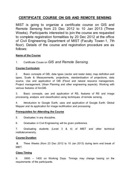
<strong>CERTIFICATE</strong> <strong>COURSE</strong> <strong>ON</strong> <strong>GIS</strong> <strong>AND</strong> <strong>REMOTE</strong> <strong>SENSING</strong><br />
MIST is going to organize a certificate course on <strong>GIS</strong> and<br />
Remote Sensing from 23 Dec 2012 to 10 Jan 2013 (Three<br />
Weeks). Participants interested to join the course are requested<br />
to complete registration formalities by 20 Dec 2012 at the office<br />
of Civil Engineering Department of MIST (Faculty Tower-1, 7th<br />
floor). Details of the course and registration procedure are as<br />
follows:<br />
Name of the Course<br />
1. Certificate Couse on <strong>GIS</strong> and Remote Sensing.<br />
Course Curriculum<br />
2. Basic concepts of <strong>GIS</strong>, data types (vector and raster data), map definition and<br />
types, Scale & Measurements, projections, standardization of projections, data<br />
source. Use and application of <strong>GIS</strong> (Flood and natural resource management,<br />
Project management, Urban Planning and other engineering aspects). Working with<br />
various features of Arc<strong>GIS</strong>.<br />
3. Basic concepts, use and application of RS, features of RS and image<br />
processing, analysis and classification using techniques of remote sensing.<br />
4. Introduction to Google Earth, uses and application of Google Earth. Global<br />
Mapper and its application for image rectification and processing<br />
Prerequisites for Attending the Course<br />
5. Graduates in any discipline.<br />
6. Graduates in Civil Engineering will be given preference.<br />
7. Graduating students (Level 3 & 4) of MIST and other technical<br />
institute/university.<br />
Course Duration<br />
8. Three Weeks (from 23 Dec 2012 to 10 Jan 2013) during term end break of<br />
MIST.<br />
Class Timing<br />
9. 0900 – 1400 on Working Days. Timings may change basing on the<br />
requirements of the participants.
Registration Fees<br />
10. Military Officers (Other than serving in MIST). Taka 10,000/-<br />
11. Graduates of MIST (Civil). 6,000/-<br />
12. MIST Staff/Faculties (Civil and Military). 5,000/-<br />
13. MIST Graduating Students (L 3 & L4): 3000/-<br />
14. Others. Taka 12,000/-<br />
Selection of Instructors<br />
15. MIST Faculties.<br />
16. Survey of Bangladesh (Military/Civil Instructors/Trainers)<br />
17. <strong>GIS</strong> experts from Naval Oceanographic/Hydro graphic Survey.<br />
18. <strong>GIS</strong> experts from RAJUK.<br />
19. Teachers from other universities (Civil)<br />
Registration Procedure<br />
20. Participants interested to join the course may download and fill up the<br />
registration form from the mist website www.mist.ac.bd. To complete the registration<br />
formalities participants must submit the registration form with payments at the Civil<br />
Engineering Department office (0800 - 1430 hours) of MIST. Registration will be<br />
accepted on first come first serve basis. Total no of seat is 30. Contact persons for<br />
this course are as under.<br />
a. Course OIC. Col Zakir Ahmed, psc, zakir@ce.mist.ac.bd,<br />
01720672238.<br />
b. Course Coordinator. Maj Joarder Md Sarwar Mujib,<br />
sarwar@ce.mist.ac.bd, 01614105171.<br />
c. Course Clerk. Corporal Masud, Mob: 01919406558.<br />
21. At the end of the course there will be a formal certificate awarding ceremony<br />
chaired by Commandant, MIST. The certificate will be designed with kind consent of<br />
the commandant and bear the emblem of MIST.