Acronym Dictionary - Upper Guadalupe River Authority
Acronym Dictionary - Upper Guadalupe River Authority
Acronym Dictionary - Upper Guadalupe River Authority

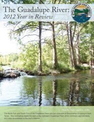
You also want an ePaper? Increase the reach of your titles
YUMPU automatically turns print PDFs into web optimized ePapers that Google loves.
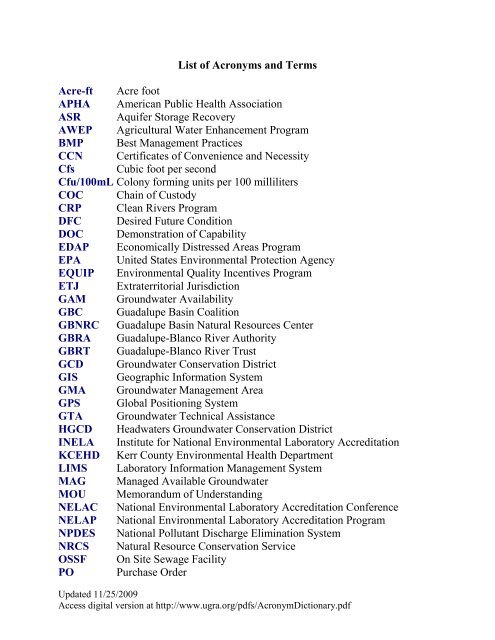
List of <strong>Acronym</strong>s and Terms<br />
Acre-ft Acre foot<br />
APHA American Public Health Association<br />
ASR Aquifer Storage Recovery<br />
AWEP Agricultural Water Enhancement Program<br />
BMP Best Management Practices<br />
CCN Certificates of Convenience and Necessity<br />
Cfs Cubic foot per second<br />
Cfu/100mL Colony forming units per 100 milliliters<br />
COC Chain of Custody<br />
CRP Clean <strong>River</strong>s Program<br />
DFC Desired Future Condition<br />
DOC Demonstration of Capability<br />
EDAP Economically Distressed Areas Program<br />
EPA United States Environmental Protection Agency<br />
EQUIP Environmental Quality Incentives Program<br />
ETJ Extraterritorial Jurisdiction<br />
GAM Groundwater Availability<br />
GBC <strong>Guadalupe</strong> Basin Coalition<br />
GBNRC <strong>Guadalupe</strong> Basin Natural Resources Center<br />
GBRA <strong>Guadalupe</strong>-Blanco <strong>River</strong> <strong>Authority</strong><br />
GBRT <strong>Guadalupe</strong>-Blanco <strong>River</strong> Trust<br />
GCD Groundwater Conservation District<br />
GIS Geographic Information System<br />
GMA Groundwater Management Area<br />
GPS Global Positioning System<br />
GTA Groundwater Technical Assistance<br />
HGCD Headwaters Groundwater Conservation District<br />
INELA Institute for National Environmental Laboratory Accreditation<br />
KCEHD Kerr County Environmental Health Department<br />
LIMS Laboratory Information Management System<br />
MAG Managed Available Groundwater<br />
MOU Memorandum of Understanding<br />
NELAC National Environmental Laboratory Accreditation Conference<br />
NELAP National Environmental Laboratory Accreditation Program<br />
NPDES National Pollutant Discharge Elimination System<br />
NRCS Natural Resource Conservation Service<br />
OSSF On Site Sewage Facility<br />
PO Purchase Order<br />
Updated 11/25/2009<br />
Access digital version at http://www.ugra.org/pdfs/<strong>Acronym</strong><strong>Dictionary</strong>.pdf
PT Proficiency Test<br />
PWPG Plateau Water Planning Group<br />
QA Quality Assurance<br />
QA/QC Quality Assurance/Quality Control<br />
QAPP Quality Assurance Project Plan<br />
QC Quality Control<br />
RWPG Regional Water Planning Group<br />
SOP Standard Operating Procedure<br />
SWCD Soil and Water Conservation District<br />
SWQM Surface Water Quality Monitoring<br />
SWQMIS Surface Water Quality Monitoring Information System<br />
TCEQ Texas Commission on Environmental Quality<br />
TD Technical Director<br />
TMDL Total Maximum Daily Load<br />
TMDL-IP Total Maximum Daily Load – Implementation Plan<br />
TNI The NELAC Institute<br />
TPDES Texas Pollutant Discharge Elimination System<br />
TPWD Texas Parks and Wildlife Department<br />
TSSWCB Texas State Soil and Water Conservation Board<br />
TWDB Texas Water Development Board<br />
USDA United States Department of Agriculture<br />
USGS United States Geological Survey<br />
WAM Water Availability Model<br />
Updated 11/25/2009<br />
Access digital version at http://www.ugra.org/pdfs/<strong>Acronym</strong><strong>Dictionary</strong>.pdf
<strong>Acronym</strong> and Terms <strong>Dictionary</strong><br />
Acre-ft – Acre foot: A unit of volume often used when referring to large scale water resources<br />
like reservoir volume or the amount of surface water rights withdrawals. It is the volume of<br />
water required to cover 1 acre of land (43,560 square feet) to a depth of 1 foot and is equal to<br />
325,851 gallons.<br />
APHA – American Public Health Association: The UGRA environmental laboratory follows<br />
some APHA drinking water testing methods.<br />
ASR – Aquifer Storage Recovery: The injection of treated surface water in the aquifer for<br />
storage during times when water is abundant, and recovery of the water during times when it is<br />
needed. A specific set of hydrologic conditions must exist for a viable ASR facility. The City of<br />
Kerrville currently operates two ASR facilities that were constructed when UGRA still oversaw<br />
this utility.<br />
AWEP – Agricultural Water Enhancement Program: A voluntary conservation initiative that<br />
provides financial and technical assistance to agricultural producers to implement agricultural<br />
water enhancement activities on agricultural land for the purposes of conserving surface and<br />
ground water and improving water quality. As part of the Environmental Quality Incentives<br />
Program (EQIP), AWEP operates through contracts with producers to plan and implement<br />
conservation practices in project areas established through partnership agreements. Under<br />
AWEP, the Natural Resources Conservation Service (NRCS) enters into partnership agreements<br />
with eligible entities that want to promote ground and surface water conservation or improve<br />
water quality on agricultural lands.<br />
BMP – Best Management Practices: Any structure, program or activity that is designed to<br />
protect environmental quality and prevent pollution. Many are required by law.<br />
CCN – Certificates of Convenience and Necessity: Certificates issued by the Texas Commission<br />
on Environmental Quality (TCEQ) to retail water or sewer providers that grant a defined area to<br />
a utility in which it can serve. Some entities, like investor owned utilities, are required to obtain<br />
a CCN before service can be provided. Other entities, like municipalities, can operate a retail<br />
water or sewer utility without a CCN.<br />
Cfs – Cubic foot per second: (also cu ft/s, cusec and ft³/s) is a volumetric flow rate unit which is<br />
equivalent to a volume of 1 cubic foot flowing every second. It is often used to describe stream<br />
flow rates.<br />
Cfu/100mL – Colony forming units per 100 milliliters: The units used when reporting bacteria<br />
test results. It refers to the number of bacteria colonies in the 100 milliliter water sample.<br />
COC – Chain of Custody: A form used by the environmental laboratory to identify a sample for<br />
analysis and document the details necessary to produce quality assured data.<br />
Updated 11/25/2009<br />
Access digital version at http://www.ugra.org/pdfs/<strong>Acronym</strong><strong>Dictionary</strong>.pdf
CRP – Clean <strong>River</strong>s Program: A state fee–funded program for water quality monitoring,<br />
assessment, and public outreach. The CRP is a collaboration of 15 partner agencies and the<br />
Texas Commission on Environmental Quality (TCEQ). UGRA is subcontracted by the<br />
<strong>Guadalupe</strong>-Blanco <strong>River</strong> <strong>Authority</strong> to sample 10 Kerr County sites four times per year for field,<br />
bacteria, and conventional parameters.<br />
DFC – Desired Future Condition: When used in the context of groundwater management it<br />
refers a quantifiable future groundwater condition. These conditions, called metrics, can be a<br />
particular groundwater level, level of water quality, volume of spring flows, etc. The chosen<br />
conditions serve as management goals and answer the question of what you want your aquifer to<br />
look like in the future. Based on the chosen desired future condition, the Texas Water<br />
Development Board (TWDB) determines how much groundwater is available for withdrawal.<br />
These volumes in turn become the permitting targets for the groundwater districts and will be<br />
used in the state's regional water planning process.<br />
DOC – Demonstration of Capability: A form used by the environmental laboratory to document<br />
that an analyst has received adequate training to perform a specific test or procedure.<br />
EDAP – Economically Distressed Areas Program: A Texas Water Development Board (TWDB)<br />
program that provides grants, loans, or a combination grant/loan for water and wastewater<br />
services in economically distressed areas or when present facilities are inadequate to meet<br />
residents' minimal needs. Fundable projects also include measures to prevent future substandard<br />
development. UGRA has applied for a grant/loan to provide water supply to residents in the<br />
Center Point area.<br />
EPA – United States Environmental Protection Agency: A federal government agency whose<br />
mission is to protect human health and the environment through environmental science, research,<br />
education and assessment efforts.<br />
EQUIP – Environmental Quality Incentives Program: A voluntary conservation program for<br />
farmers and ranchers that promotes agricultural production and environmental quality as<br />
compatible national goals. EQIP offers financial and technical help to assist eligible participants<br />
install or implement structural and management practices on eligible agricultural land.<br />
ETJ – Extraterritorial Jurisdiction: The legal ability of a government to exercise authority<br />
beyond its normal boundaries.<br />
GAM – Groundwater Availability Model: The process of developing and using computer<br />
programs to estimate future trends in the amount of water available in an aquifer and is based on<br />
hydrogeologic principles, actual aquifer measurements, and stakeholder guidance.<br />
GBC – <strong>Guadalupe</strong> Basin Coalition: A voluntary association of businesses, Chambers of<br />
Commerce, and governmental entities in counties along the <strong>Guadalupe</strong> and San Marcos rivers<br />
that are bonded by a common concern for the sustained viability of the <strong>Guadalupe</strong> and San<br />
Marcos rivers both economically and environmentally. UGRA is a non voting member of the<br />
GBC.<br />
Updated 11/25/2009<br />
Access digital version at http://www.ugra.org/pdfs/<strong>Acronym</strong><strong>Dictionary</strong>.pdf
GBNRC – <strong>Guadalupe</strong> Basin Natural Resources Center: The building where the UGRA offices<br />
are located. The building is owned by the State of Texas, but UGRA is the perpetual steward of<br />
the property.<br />
GBRA – <strong>Guadalupe</strong>-Blanco <strong>River</strong> <strong>Authority</strong>: Provides stewardship for the water resources in its<br />
ten-county statutory district, which includes Kendall, Comal, Hays, Caldwell, <strong>Guadalupe</strong>,<br />
Gonzales, DeWitt, Victoria, Calhoun and Refugio counties.<br />
GBRT – <strong>Guadalupe</strong>-Blanco <strong>River</strong> Trust: A 501(c)(3) nonprofit land trust organization that was<br />
developed to conserve land in the <strong>Guadalupe</strong> <strong>River</strong> watershed for its natural, recreational, scenic,<br />
historic and productive value. It was founded in 2001 by the <strong>Guadalupe</strong>-Blanco <strong>River</strong> <strong>Authority</strong><br />
and UGRA has also partnered with the Trust. Currently, Director Kercheville serves as a trustee<br />
on the GBRT board.<br />
GCD – Groundwater Conservation District: Local authorities created by the legislature required<br />
to develop and implement groundwater management plans that must be submitted to the Texas<br />
Water Development Board (TWBD) for approval. There are 95 groundwater districts in Texas<br />
and the Headwater Groundwater Conservation District (HGCD) is the GCD in Kerr County.<br />
GIS – Geographic Information System: A system that captures, stores, analyzes, manages, and<br />
presents data that is linked to location. Technically, a GIS is a system which includes mapping<br />
software and its application to remote sensing, land surveying, aerial photography, mathematics,<br />
photogrammetry, geography, and tools that can be implemented with GIS software.<br />
GMA – Groundwater Management Area: The Texas Water Development Board (TWDB)<br />
designated Groundwater Management Area boundaries in response to legislation passed in 2001 with<br />
the objective to delineate areas considered suitable for management of groundwater resources. There<br />
are 16 GMAs covering the entire state and Kerr County is in GMA 9. A GMA should ideally<br />
coincide with the boundaries of a groundwater reservoir or a subdivision of a groundwater reservoir,<br />
but it may also be defined by other factors, including the boundaries of political subdivisions. GMAs<br />
are tasked with establishing desired future conditions (DFC) for the relevant aquifers within the<br />
management area.<br />
GPS – Global Positioning System: A U.S. space-based global navigation satellite system. It<br />
provides reliable positioning, navigation, and timing services to worldwide users on a continuous<br />
basis in all weather, day and night, anywhere on or near the Earth. GPS has become a widely used<br />
to aid navigation worldwide.<br />
GTA – Groundwater Technical Assistance: A section of the Groundwater Resources Division of<br />
the Texas Water Development Board. The purpose of the section is to provide technical<br />
information to Texans on the groundwater resources of the state.<br />
HGCD – Headwaters Groundwater Conservation District: Part of the Hill Country Priority<br />
Groundwater Management Area and was created by the Texas Legislature in January 1991. The<br />
District was organized to protect the underground water resources of Kerr County. It registers<br />
Updated 11/25/2009<br />
Access digital version at http://www.ugra.org/pdfs/<strong>Acronym</strong><strong>Dictionary</strong>.pdf
and permits wells drilled in the county and investigates the aquifers to determine appropriate<br />
plans for future development.<br />
INELA – Institute for National Environmental Laboratory Accreditation: Organization<br />
established to assist NELAC’s move towards self-sufficiency. INELA is a not-for-profit<br />
educational and scientific voluntary consensus organization whose mission is to foster the<br />
generation of environmental laboratory data of known and documented quality through the<br />
development of performance standards for accreditation of environmental laboratories.<br />
KCEHD – Kerr County Environmental Health Department: Kerr County Department<br />
responsible for providing for the health, safety, and welfare of Kerr County residents and the<br />
environment. They do this by ensuring that all on-site sewage facilities (OSSF) systems are<br />
installed in accordance with the State’s rules and regulations and that all OSSF complaints are<br />
investigated. KCEHD staff also actively enforces solid waste public nuisances, illegal dumping,<br />
and illegal burning laws as outlined in Texas State Codes.<br />
LIMS – Laboratory Information Management System: The environmental laboratory’s database<br />
that stores sample test information and results.<br />
MAG – Managed Available Groundwater: The desired future condition (DFC) is used to<br />
develop a volumetric number of water available to withdraw from the aquifers – the managed<br />
available groundwater. The MAG allows the groundwater districts to issue permits only up to<br />
the total amount of groundwater available to support the DFC.<br />
MOU – Memorandum of Understanding: A document describing a bilateral or multilateral<br />
agreement between parties.<br />
NELAC – National Environmental Laboratory Accreditation Conference: A cooperative<br />
association of state and federal agencies formed to establish and promote mutually acceptable<br />
performance standards for the operation of environmental laboratories. The standards cover both<br />
analytical testing of environmental samples and the laboratory accreditation process. As of July<br />
1, 2008 any data reported to the State of Texas needs to be generated by a NELAC accredited<br />
lab. The UGRA environmental laboratory is NELAC accredited.<br />
NELAP – National Environmental Laboratory Accreditation Program:<br />
implements the NELAC standards.<br />
The program that<br />
NPDES – National Pollutant Discharge Elimination System - Water pollution degrades surface<br />
waters making them unsafe for drinking, fishing, swimming, and other activities. As authorized<br />
by the Clean Water Act, the NPDES permit program controls water pollution by regulating point<br />
sources that discharge pollutants into waters of the United States.<br />
NRCS – Natural Resource Conservation Service: An agency of the U.S. Department of<br />
Agriculture (USDA) formerly known as the Soil Conservation Service that provides assistance to<br />
private landowners and managers to conserve their soil, water, and other natural resources.<br />
Updated 11/25/2009<br />
Access digital version at http://www.ugra.org/pdfs/<strong>Acronym</strong><strong>Dictionary</strong>.pdf
OSSF – On Site Sewage Facility: Wastewater systems designed to treat and dispose of effluent<br />
on the same property that produces the wastewater. A septic tank and drainfield combination is<br />
the oldest and most common type of OSSF, although newer aerobic and biofilter units exist<br />
which represent scaled down versions of municipal sewage treatments. OSSFs account for<br />
approximately 25% of all domestic wastewater treatment in the United States.<br />
PO – Purchase Order: All UGRA purchases must be accompanied by an approved purchase<br />
order form.<br />
PT – Proficiency Test: A blind test purchased from a NELAC approved provider. The<br />
environmental laboratory must pass two PTs per year for each of our NELAC certified tests.<br />
PWPG – Plateau Water Planning Group:<br />
(RWPG) also known as Region J.<br />
Kerr County’s Regional Water Planning Group<br />
QA – Quality Assurance: Refers to the planned and systematic procedures to determine whether<br />
the data produced is meeting specified requirements.<br />
QA/QC – Quality Assurance/Quality Control: The entire quality system to ensure only the<br />
highest quality data is produced.<br />
QAPP – Quality Assurance Project Plan: A state approved plan outlining the specific<br />
monitoring plan and quality objectives for a surface water quality monitoring program. All<br />
surface water quality data submitted to the Texas Commission on Environmental Quality<br />
(TCEQ) must be collected under an approved QAPP. UGRA abides by QAPPs for the CRP and<br />
TMDL programs.<br />
QC – Quality Control: A procedure or set of procedures intended to ensure that data produced<br />
adheres to a defined set of quality criteria or meets the requirements of the client or customer.<br />
RWPG – Regional Water Planning Group: Texas is divided into 16 regional planning areas that<br />
are responsible for preparing and adopting a regional water plan for their area – surface water<br />
and groundwater – to ensure each county in the region has sufficient water to sustain its<br />
projected population and economic needs. RWPG use groundwater availability models (GAM)<br />
and surface water availability models (WAM) to plan water supply and/or conservation projects.<br />
There has been a conflict recently because subsequent legislation created Groundwater<br />
Management Areas (GMAs) and tasked them with developing desired future conditions (DFC)<br />
for their area. The RWPGs must now include these conditions in their regional water plans but<br />
have not had a say in their development.<br />
SWCD – Soil and Water Conservation District: A subdivision of state government (TSSWCB)<br />
brought into existence by a vote of the landowners within the boundaries of a district. It is<br />
administered by a board of five directors who are elected by their fellow landowners. SWCD<br />
directors must have knowledge of the conservation problems in their district and have the ability<br />
to organize people and resources for effective action in conserving soil and water, thereby<br />
making the land more productive. Kerr County is SWCD #217.<br />
Updated 11/25/2009<br />
Access digital version at http://www.ugra.org/pdfs/<strong>Acronym</strong><strong>Dictionary</strong>.pdf
SOP – Standard Operating Procedure: A set of instructions outlining the step by step process<br />
needed to accurately complete sample analysis or collection. All UGRA lab technicians are<br />
trained to follow the SOPs for the testing they conduct.<br />
SWQM – Surface Water Quality Monitoring: A Texas Commission on Environmental Quality<br />
(TCEQ) program that monitors the quality of surface water to evaluate physical, chemical, and<br />
biological characteristics of aquatic systems. Water quality is monitored in relation to human<br />
health concerns, ecological condition, and designated uses. The data collected under this<br />
program provides a basis for effective policies that promote the protection, restoration, and wise<br />
use of surface water in Texas.<br />
SWQMIS – Surface Water Quality Monitoring Information System: The Texas Commission on<br />
Environmental Quality (TCEQ) database that stores surface water quality data used for<br />
monitoring and assessment. Data must meet specific objectives outlined in the Quality<br />
Assurance Project Plan (QAPP) in order to be included in SWQMIS<br />
TCEQ – Texas Commission on Environmental Quality: The environmental agency for the State<br />
of Texas regulating air, water, and the safe management of wastes.<br />
TD – Technical Director: A laboratory position with specific qualifications outlined by the<br />
National Environmental Accreditation Conference (NELAC). All NELAC certified labs must<br />
maintain at least one qualified Technical Director and Deputy TD.<br />
TMDL – Total Maximum Daily Load: A calculation of the maximum amount of a pollutant that<br />
a water body can receive and still safely meet water quality standards. Section 303(d) of the<br />
Clean Water Act requires states to develop lists of impaired waters. These are waters that are too<br />
polluted or otherwise degraded to meet the water quality standards set by the states. Once a<br />
water body is listed as impaired, the law requires that the states develop TMDLs for these waters.<br />
A four miles reach of the <strong>Upper</strong> <strong>Guadalupe</strong> <strong>River</strong> in Kerrville was listed as impaired due to high<br />
E. coli bacteria levels in 2002 and a TMDL was adopted in 2007.<br />
TMDL-IP – Total Maximum Daily Load – Implementation Plan: Once a TMDL is adopted by<br />
the state and EPA, a plan must be developed to identify the pollution reduction strategies<br />
necessary to achieve the desired load reductions and a detailed plan for implementation. The<br />
Texas Commission on Environmental Quality (TCEQ) is responsible for developing the<br />
implementation plan. UGRA received a three-year grant under section 319 of the Clean Water<br />
Act to develop an implementation plan at the local level in conjunction with a local stakeholder<br />
group.<br />
TNI – The NELAC Institute: A 501(c)(3) non-profit organization whose mission is to foster the<br />
generation of environmental data of known and documented quality through an open, inclusive,<br />
and transparent process that is responsive to the needs of the community. TNI provides guidance<br />
for the NELAC certification process.<br />
TPDES – Texas Pollutant Discharge Elimination System: A regulatory program to control<br />
discharges of pollutants to surface waters. The state of Texas assumed the authority to<br />
Updated 11/25/2009<br />
Access digital version at http://www.ugra.org/pdfs/<strong>Acronym</strong><strong>Dictionary</strong>.pdf
administer the National Pollutant Discharge Elimination System (NPDES) program in Texas on<br />
Sept. 14, 1998. NPDES is a federal regulatory program to control discharges of pollutants to<br />
surface waters of the United States. The Texas Commission in Environmental Quality (TCEQ)<br />
TPDES program now has federal regulatory authority over discharges of pollutants to Texas<br />
surface water, with the exception of discharges associated with oil, gas, and geothermal<br />
exploration and development activities, which are regulated by the Railroad Commission of<br />
Texas.<br />
TPWD – Texas Parks and Wildlife Department: The state agency to manage and conserve the<br />
natural and cultural resources of Texas and to provide hunting, fishing and outdoor recreation<br />
opportunities for the use and enjoyment of present and future generations.<br />
TSSWCB – Texas State Soil and Water Conservation Board: The state agency that administers<br />
Texas’ soil and water conservation law and coordinates conservation and nonpoint source<br />
pollution abatement programs throughout the State. TSSWCB offers technical assistance to the<br />
state’s 217 soil and water conservation districts (SWCDs).<br />
TWDB – Texas Water Development Board: The state agency that provides leadership,<br />
planning, financial assistance, information, and education for the conservation and responsible<br />
development of water for Texas.<br />
USDA – United States Department of Agriculture: A federal government agency responsible for<br />
developing and executing policy on farming, agriculture, and food. It aims to meet the needs of<br />
farmers and ranchers, promote agricultural trade and production, work to assure food safety,<br />
protect natural resources, foster rural communities and end hunger in the United States and<br />
abroad.<br />
USGS – United States Geological Survey: A scientific agency of the United States government<br />
with no regulatory responsibility. The USGS provides reliable scientific information in four<br />
main disciplines: biology, geography, geology, and hydrology.<br />
WAM – Water Availability Model: The process of developing and using computer programs to<br />
estimate future trends in the amount of water available. They incorporate stream flow and<br />
reservoir levels over a historical period of record and adhere to the prior appropriation doctrine,<br />
which governs Texas’ water right priority system. WAMs are the fundamental tools used to<br />
determine surface water availability for water rights permitting, and contain information about<br />
water rights in each respective river basin.<br />
Updated 11/25/2009<br />
Access digital version at http://www.ugra.org/pdfs/<strong>Acronym</strong><strong>Dictionary</strong>.pdf