3 Jackson (d. – Ca. 1906 ) - Slumach
3 Jackson (d. – Ca. 1906 ) - Slumach
3 Jackson (d. – Ca. 1906 ) - Slumach

Create successful ePaper yourself
Turn your PDF publications into a flip-book with our unique Google optimized e-Paper software.
3<br />
<strong>Jackson</strong> (d. <strong>–</strong> <strong>Ca</strong>. <strong>1906</strong> )<br />
An individual most commonly know by only the last<br />
name of <strong>Jackson</strong> is the undisputed successor in the saga<br />
of the Pitt Lake Legend. Following in <strong>Slumach</strong>’s footsteps,<br />
<strong>Jackson</strong> has undeniably gained legendary status<br />
that equals, if not exceeds that of his Native predecessor.<br />
Although there are a variety of entertaining accounts<br />
describing how <strong>Jackson</strong> initially became involved in the<br />
legend and located his elusive creek<br />
laden with millions of dollars worth<br />
of gold there is, not surprisingly,<br />
very little that has or can actually be<br />
confirmed about him. Some believe<br />
that his last name was not <strong>Jackson</strong><br />
but rather Hill or Hall. Most agree<br />
that his first name was either John<br />
or William. Regardless of the cycle<br />
of debate, I will continue with tradition<br />
and refer to the mysterious<br />
prospector as <strong>Jackson</strong>.<br />
Did <strong>Jackson</strong> find a hidden creek full<br />
of gold on his own accord Or did<br />
he kill his Native guide and bury<br />
him at the foot of a tent shaped rock<br />
after being shown the location<br />
The most recognized basic recital<br />
is that <strong>Jackson</strong> located a creek laden<br />
with gold nuggets somewhere in<br />
the mountains beyond the head of Pitt Lake. Loading<br />
up with as much gold as he could carry from the creek<br />
he started back towards civilization. Unable to continue<br />
with his full load he buried a substantial quantity under<br />
a tent shaped rock somewhere between the source and<br />
the head of Pitt Lake. <strong>Jackson</strong> returned to San Francisco<br />
where he died before he could return to the site.<br />
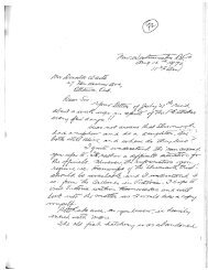
Barlee’s original at the end.<br />
Prior to his death he wrote a letter to an unknown<br />
friend giving directions to the location of both the tent<br />
shaped rock and the gold laden creek. This letter is<br />
commonly referred to as the ‘<strong>Jackson</strong>’ letter. Some written<br />
accounts strongly suggest that a crude map accompanied<br />
his letter.<br />
According to all accounts <strong>Jackson</strong> died in San Francisco<br />
sometime around the turn of the century. In an attempt<br />
to determine the date and under what circumstances he<br />
died I contacted the Department of Public Health Bureau<br />
of Records in San Francisco and requested a search<br />
for the death certificate of one John or William <strong>Jackson</strong>.<br />
The years searched were from 1891 to 1916.<br />
The bureau responded to my request by stating that all<br />
local records prior to April 18, <strong>1906</strong> were destroyed in<br />
the great San Francisco fire of that year. They further<br />
informed me that they were unable to locate any record<br />
of any John or William <strong>Jackson</strong> for the years <strong>1906</strong> to<br />
1916.<br />
Again, that ever frustrating shadow that obscures the<br />
facts remained except in this particular case it produced<br />
an unexpected dilemma.<br />
There are no records of either a<br />
John or a William <strong>Jackson</strong> in the<br />
City or County of San Francisco and<br />
therefore one can neither prove nor<br />
disprove the existence of <strong>Jackson</strong><br />
or accurately research the accounts<br />
written about him. Given these<br />
findings, one can only assume that<br />
<strong>Jackson</strong> died in San Francisco sometime<br />
prior to April 18, <strong>1906</strong>.<br />
It is interesting to note two curiosities<br />
found in the BC Archives<br />
during the course of my research<br />
which may be of interest to anyone<br />
interested in conducting further research<br />
into <strong>Jackson</strong>. First, a 50 year<br />
old man identified only as <strong>Jackson</strong>,<br />
his first name is listed as unknown,<br />
died in New Westminster on August<br />
21, 1902. Second, in the collection of Attorney Generals<br />
Correspondence 1872 <strong>–</strong>1937, there is a reference to a 1905<br />
murder of an individual named <strong>Jackson</strong>.<br />
Regardless of the varied accounts describing <strong>Jackson</strong>’s<br />
activities and the lack of any specific dates <strong>Jackson</strong>’s<br />
undisputed claim to fame is definitely based almost<br />
entirely on the infamous letter he wrote prior to his<br />
death. The following is a copy of <strong>Jackson</strong>’s letter, courtesy<br />
of well known and respected historian and author,<br />
Mr. Bill Barlee. This copy was date stamped May 28,<br />
1924 by the Gold Commissioners office in Grand Forks,<br />
B.C. The 1924 letter is a type written copy of <strong>Jackson</strong>’s<br />
original letter and includes all errors in grammar and<br />
spelling found in the original letter. The missing word<br />
is smudged and illegible on the original letter so I have<br />
simply labelled and highlighted the missing word as<br />
(unknown).<br />
Copyright © 2002 Robert W. Nicholson
Some believe that the <strong>Jackson</strong> letter is legitimate while<br />
others believe that it was a hoax perpetrated by the<br />
early media in an attempt to increase newspaper sales<br />
by adding to the rumors surrounding <strong>Slumach</strong>. Skeptics<br />
that disagree with the authenticity of <strong>Jackson</strong>’s letter<br />
argue the point that if there is a canyon one and one<br />
half miles in length containing a creek full of gold, why<br />
has it not been found by one of the suspected tens of<br />
thousands who have searched for it for the better part<br />
of a century One must take into consideration that the<br />
letter was written from memory by a dying man without<br />
the assistance of any topographical maps. A letter<br />
written under these conditions is not very likely to be<br />
anywhere near as accurate as most who try and follow<br />
the directions outlined in it would hope it to be.<br />
<strong>Jackson</strong> died during a time period when an influenza<br />
epidemic was taking more lives than all other illnesses<br />
combined. It is most probable that he was suffering<br />
from influenza when he wrote his letter. It is not uncommon<br />
for a person with any type of terminal illness<br />
to also deteriorate mentally. Fevers are characteristic of<br />
virtually all illnesses which when left unchecked or are<br />
untreatable ultimately cause hallucinations of varying<br />
degrees of intensity. <strong>Jackson</strong>’s deteriorating health undoubtedly<br />
affected his memory which would account<br />
for the elusive and somewhat distorted directions given<br />
in his letter. With fading memory <strong>Jackson</strong> provided<br />
what he believed to be sufficient information and directions<br />
for the recipient of his letter to follow and find the<br />
location of his rich placer discovery. I am confident that<br />
the interpretation of the following points alone will offer<br />
consideration of the accuracy of the directions given<br />
in the letter under the suspected circumstances.<br />
<strong>Jackson</strong> specifically stated that the water in the creek<br />
was almost white. He would not have used this term<br />
lightly as a general reference. Almost every creek in the<br />
search region flows down very steep inclines producing<br />
white water. His description is very specific and was<br />
intended to identify the specific location of the creek.<br />
Secondly, <strong>Jackson</strong> writes that the location is a two or<br />
three day hike from the lake and it may take a year or<br />
more to find. In addition to giving the approximate<br />
distance from the lake, which does put the location<br />
somewhere in the Stave Glacier region, he is likely trying<br />
to say that the location is under a blanket of snow<br />
and ice that does not necessarily melt sufficiently each<br />
and every year to expose the creek.<br />
Thirdly, <strong>Jackson</strong> unmistakably places an extremely high<br />
value on a tent shaped rock. Not only because he buried<br />
part of his gold there but also because it is a significant<br />
directional indicator to the location of the gold bearing<br />
creek itself.<br />
I have seen a dozen or so tent shaped rocks within the<br />
general search area. Some of these tent shaped rocks are<br />
as large as modern houses. The only location that I am<br />
aware of in the entire search area that contains any rock<br />
that is suitable enough to fit <strong>Jackson</strong>’s description is<br />
indeed very distinct.<br />
The location of what I refer to as the “<strong>Jackson</strong> rock” is of<br />
interest to at least three independent search parties that<br />
I am aware of. The location was initially provided to me<br />
by two prospectors who had searched the surrounding<br />
area several times throughout the years. They claim to<br />
have located the “<strong>Jackson</strong> rock” by following the directions<br />
given on what they identified as a very old crude<br />
map drawn on a deer hide. The two prospectors were<br />
convinced that the deer hide map had been drawn by<br />
<strong>Jackson</strong> himself.<br />
Unfortunately the existence of the map could not be<br />
confirmed. The one prospector no longer had possession<br />
of the hide map. He claimed that it had either been<br />
lost or destroyed by his former spouse during a family<br />
break-up years prior to our meeting. The prospectors<br />
were continuing their search based on memory. This is<br />
the only piece of indirect information that suggests at<br />
a circumstantial level that <strong>Jackson</strong> may have provided a<br />
crude map with his letter. The particular “<strong>Jackson</strong> rock”<br />
to which I refer is in fact huge. It sits alone on a bench<br />
not far from Iceworm Creek and definitely seems to be<br />
out of place in its surroundings. It is similar in appearance<br />
and somewhat larger than the Native “standing<br />
rock” west of Keremeos, B.C..<br />
The “<strong>Jackson</strong> rock” measures approximately 100 feet<br />
by 100 feet at the base by 70 feet in height. It has a<br />
slight overhang or lean in a southerly direction. On the<br />
ground a few feet out from the base but still just under<br />
the peak of the overhang are several very old fire pits<br />
spaced out to form the shape of a semi-circle or arch.<br />
At the base, on one side of the “<strong>Jackson</strong> rock” is an obviously<br />
old depression measuring approximately 4 feet by<br />
3 feet by 1 foot in depth. The depression is not a natural<br />
occurrence. The ground cover that has re-established<br />
itself over the depression suggests that the hole had<br />
been dug many decades earlier. About 30 feet to one<br />
side of the “<strong>Jackson</strong> rock” are two slabs of rock leaning<br />
together that definitely give appearance of a pup-tent.<br />
These slabs measure approximately 8 feet by 8 feet in<br />
length by 5 feet in height. One can actually crawl inside<br />
Copyright © 2002 Robert W. Nicholson
this natural rock structure. This itself is undeniably a<br />
tent shaped rock without comparison.<br />
I am fairly confident that this rock formation is the<br />
tent shaped rock that <strong>Jackson</strong> was referring to simply<br />
because of the hundreds of tent shaped rocks in<br />
the search area this is the only one that is definitely<br />
unique, can not be missed, and is within the travel<br />
distance identified in his letter. And, these are the only<br />
two rocks on the entire bench.<br />
No marks have been located or identified on either the<br />
“<strong>Jackson</strong> rock” or the tent shaped slabs. However, the<br />
inside of the slabs unfortunately were not examined.<br />
<strong>Jackson</strong> literally wrote that there was a mark cut out<br />
“in” the rock not “on” the rock. It has been suggested<br />
that the mark may actually be on the inside of the slabs.<br />
Only a re-examination of the site can determine if <strong>Jackson</strong><br />
literally meant “in” or “on” the rock.<br />
I have been independently advised that the ashes from<br />
the fire pits were carbon dated a few years ago. The<br />
carbon dating results identified the ashes as being circa<br />
very early 1800s.<br />
The location of this site combined with he carbon dating<br />
results and Duff ’s documentation, discussed in the<br />
previous chapter, are strong indicators that this location<br />
is not only of interest to the <strong>Jackson</strong> portion of the<br />
Pitt Lake Legend it, may also be of significant historical<br />
value related to Native culture and history.<br />
The Archaeology department at The University of British<br />
Columbia was unaware of this site when I contacted<br />
them. Subsequent consultation with an independent<br />
archaeologist has proven to be most interesting and<br />
enlightening.<br />
Without physically examining this site, the archaeological<br />
consultant is confident that the location may<br />
actually be an undocumented site of an ancient Native<br />
seasonal hunting camp. This opinion is based on several<br />
factors of which two principle ones are notable for<br />
the subject of this writing.<br />
Firstly, the semi-circle of old fire pits are strong indicators<br />
that the pits were used by Native hunting parties<br />
for drying meat hung over the boulder. Native hunting<br />
parties commonly dried their meat at the site of their<br />
seasonal hunting camps because they were able to pack<br />
out far greater quantities of dried meat than fresh meat<br />
to the main encampment or settlement.<br />
Secondly, the preferred meat of the Natives identified<br />
as having traditional access to the area was black bear,<br />
closely followed by mountain-goat. The location is<br />
almost in the center of an area still well known for both<br />
species. The location is not far off of the Iceworm Creek<br />
trail that leads from Glacier Lake to the Pitt River.<br />
As a general point of interest, the archaeologist has<br />
additionally expressed an interest in the possible association<br />
of this site to the Native tribe identified as the<br />
Squalls by Duff in the previous chapter.<br />
The archaeologist’s professional opinion, even without<br />
physical assessment of the sight, does, in itself, offer<br />
an interesting correlation to the fact that <strong>Slumach</strong> met<br />
a Port Douglas Native hunting party and <strong>Jackson</strong> tells<br />
his friend to take trustworthy Natives and only tell<br />
people he is going on a hunting trip. As a final reference<br />
to <strong>Jackson</strong>’s letter it is curious to note that he did not<br />
identify any lake by name and simply referred to the<br />
location of the creek as being two or three days from<br />
“the lake.”<br />
The only reference that I can find that places <strong>Jackson</strong><br />
at Pitt Lake is found in a story which again features<br />
<strong>Slumach</strong>’s nephew, Peter Pierre. Peter Pierre claimed<br />
to have found <strong>Jackson</strong> on the eastern shore of Pitt Lake<br />
across from Little Goose Island in 1903. <strong>Jackson</strong> was<br />
physically exhausted and extremely sick. He claimed<br />
to have been helped to the lake shore by and old Native<br />
women. As Pierre paddled the canoe down the<br />
Lake, <strong>Jackson</strong> told him about dense fogs, impenetrable<br />
underbrush, unbelievable “Devils club” and other hardships<br />
he had endured.<br />
On the trip down the Lake <strong>Jackson</strong> also made reference<br />
to hot springs. There are two known locations of hot<br />
spring in the general search area. One is located on the<br />
west side of the upper Pitt River, north of Alvin, a short<br />
distance upstream from where the main logging road<br />
bridge crosses the river. The second is located at the<br />
junction of the North and South Sloquet Creeks. There<br />
is also rumored to be a third hot spring located somewhere<br />
in the Iceworm Creek area. This third hot spring,<br />
being located in the same area as what I have referred to<br />
as the “<strong>Jackson</strong> rock” does prove uniquely interesting.<br />
During the time period in which <strong>Jackson</strong> was undoubtedly<br />
involved in his adventures there was an extensive<br />
prospecting frenzy taking place in the upper Harrison<br />
Lake area, specifically in the vicinity of Fire Mountain.<br />
In addition to the mineral finds in the Harrison Lake<br />
area, Port Douglas at the north end of Harrison Lake<br />
had been the prospectors’ gateway to the northern gold<br />
fields. The entire area had been and was once again<br />
Copyright © 2002 Robert W. Nicholson
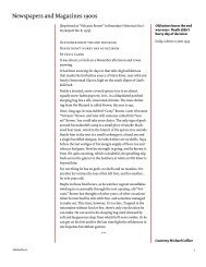
Section of one of the earlier maps of B.C. produced by the British Royal Navy and British Royal Engineers on November 1859.<br />
<strong>Jackson</strong> would not have had access to any maps with noticeable more detail. Inset: 1899 photograph of a prospector in the<br />
Stikine area of B.C. <strong>Jackson</strong> may very well have taken similar risks descending into his gold-laden creek from the sharp ridge<br />
above.<br />
swarming with prospectors and fortune hunters. Harrison<br />
Lake was commonly referred to as ‘the lake’ simply<br />
because everyone knew the location being referred to.<br />
No one really knows anything about <strong>Jackson</strong>’s background.<br />
It is definitely not out of the question to<br />
suggest that he was one of the countless prospectors<br />
combing the area around the upper Harrison Lake area<br />
during the 1890s and early 1900s.<br />
<strong>Jackson</strong> states in his letter he had been prospecting for<br />
over two months. It is highly probable that he began<br />
prospecting in the Harrison Lake area. Expanding his<br />
search area over a two month period, he ultimately<br />
made his discovery somewhere between Fire Mountain<br />
and the upper Pitt River.<br />
After discovering his bonanza, he made a rational decision<br />
to make his way back towards civilization via an<br />
alternate and unfamiliar route instead of going back in<br />
the direction of Port Douglas and Harrison Lake.<br />
His choice of direction using an alternate route that<br />
ultimately ended at Pitt Lake would have been made in<br />
order to avoid the hordes of prospectors concentrated<br />
in the area between Harrison Lake and the upper Stave<br />
River. By avoiding as many of these prospectors as<br />
possible <strong>Jackson</strong> would have significantly reduced his<br />
chances of being robbed or otherwise having his discovery<br />
prematurely identified.<br />
Many historical accounts describing prospectors’ activities<br />
identify the paranoia aspect of their lives. These<br />
early prospectors constantly took excessive precautions<br />
against being followed to their secret locations. Many<br />
of them would frequently travel miles and often days<br />
out of their way to avoid detection. Given the mother<br />
lode that <strong>Jackson</strong> writes about, it is more than probable<br />
that he took all precautions he considered necessary to<br />
avoid detection.<br />
Copyright © 2002 Robert W. Nicholson
Photograph taken in a small valley near Stave Glacier. The Devils Club in this photo is approximately 10 feet tall and several<br />
inches in diameter. It is so large that it dwarves the two men barely visible in the upper left of the photograph.<br />
Aerial photograph showing a small creek disappearing and then reappearing several hundred feet away. Numerous creeks<br />
in the search area flow intermittently through subterranean channels. Some of the smaller creeks simply disappear underground.<br />
Copyright © 2002 Robert W. Nicholson
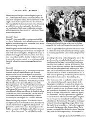
Page from N.L. (Bill) Barlee’s Lost Mines and Historic Treasures of British Columbia, (Hanckock House 1993) showing<br />
the <strong>Jackson</strong> Letter.<br />
Copyright © 2002 Robert W. Nicholson