Floyds Fork Watershed - MSD
Floyds Fork Watershed - MSD
Floyds Fork Watershed - MSD

Create successful ePaper yourself
Turn your PDF publications into a flip-book with our unique Google optimized e-Paper software.
WATERS of Jefferson County: July 1, 2001 – June 30, 2002<br />
<strong>Floyds</strong> <strong>Fork</strong> <strong>Watershed</strong><br />
3.3 FLOYDS FORK<br />
This report is an update to the WATERS of Jefferson County Report – July 1, 2000 to<br />
June 30, 2001. For additional information on the <strong>Floyds</strong> <strong>Fork</strong> <strong>Watershed</strong>, refer to the<br />
WATERS of Jefferson County Report –<br />
July 1, 2000 to June 30, 2001 located on<br />
the CD in Appendix I.<br />
Exhibit 6 illustrates several features of the<br />
Municipal Separate Storm Sewer System<br />
(MS4) and Sanitary Sewer Overflow<br />
(SSO) Programs in the <strong>Floyds</strong> <strong>Fork</strong> <strong>Watershed</strong>.<br />
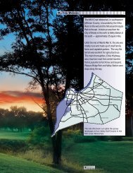
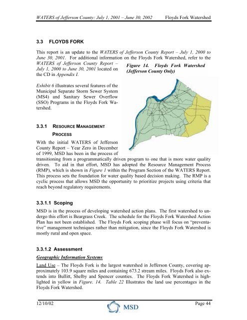
Figure 14. <strong>Floyds</strong> <strong>Fork</strong> <strong>Watershed</strong><br />
(Jefferson County Only)<br />
3.3.1 RESOURCE MANAGEMENT<br />
PROCESS<br />
With the initial WATERS of Jefferson<br />
County Report – Year Zero in December<br />
of 1999, <strong>MSD</strong> has been in the process of<br />
transitioning from a programmatically driven program to one that is more water quality<br />
driven. To aid in that effort, <strong>MSD</strong> has adopted the Resource Management Process<br />
(RMP), which is shown in Figure 1 within the Program Section of the WATERS Report.<br />
This process sets the foundation for water quality based decision making. The RMP is a<br />
cyclic process that allows <strong>MSD</strong> the opportunity to prioritize projects using criteria that<br />
reach beyond regulatory requirements.<br />
3.3.1.1 Scoping<br />
<strong>MSD</strong> is in the process of developing watershed action plans. The first watershed to undergo<br />
this effort is Beargrass Creek. The schedule for the <strong>Floyds</strong> <strong>Fork</strong> <strong>Watershed</strong> Action<br />
Plan has not been established. The <strong>Floyds</strong> <strong>Fork</strong> scoping phase will focus on “preventative”<br />
management techniques rather than mitigation, since the <strong>Floyds</strong> <strong>Fork</strong> <strong>Watershed</strong> is<br />
mostly rural and open space.<br />
3.3.1.2 Assessment<br />
Geographic Information Systems<br />
Land Use – The <strong>Floyds</strong> <strong>Fork</strong> is the largest watershed in Jefferson County, covering approximately<br />
103.9 square miles and containing 673.2 stream miles. <strong>Floyds</strong> <strong>Fork</strong> also extends<br />
into Bullitt, Shelby and Spencer counties. The <strong>Floyds</strong> <strong>Fork</strong> <strong>Watershed</strong> is highlighted<br />
in yellow in Figure. 14. Table 22 Illustrates the land use percentages in the<br />
<strong>Floyds</strong> <strong>Fork</strong> <strong>Watershed</strong>.<br />
12/10/02 Page 44
WATERS of Jefferson County: July 1, 2001 – June 30, 2002<br />
<strong>Floyds</strong> <strong>Fork</strong> <strong>Watershed</strong><br />
Table 22. <strong>Floyds</strong> <strong>Fork</strong> - Land Use Percentages (1998)<br />
Total<br />
Impervious Undeveloped Commercial Parks Public Industrial Residential<br />
13.0 58.6 1.1 2.9 0.6 5.1 31.7<br />
Monitoring<br />
<strong>MSD</strong> has performed monitoring activities within the <strong>Floyds</strong> <strong>Fork</strong> <strong>Watershed</strong>. Below is a<br />
compilation of those activities:<br />
Monitoring Activities<br />
Ambient Monitoring - <strong>MSD</strong> has five long-term monitoring locations in the<br />
<strong>Floyds</strong> <strong>Fork</strong> <strong>Watershed</strong> as part of their ambient monitoring program. Each location has a<br />
minimonitor and a United States Geological Survey (USGS) stream flow gauge, which<br />
operate continuous node-collectors. Data is recorded at intervals of 15 minutes, 24 hours<br />
per day.<br />
Water quality data collected during this reporting period has been analyzed. The majority<br />
of the data was collected with minimonitors from the ambient monitoring sites. A summary<br />
of the water quality violations for all of Jefferson County can be found in the<br />
WATERS of Jefferson County Report – July 1, 2001 to June 30, 2002 CD located in Appendix<br />
I. Table 23 shows a summary of the water quality violations within the <strong>Floyds</strong><br />
<strong>Fork</strong> <strong>Watershed</strong>.<br />
Table 23. Summary of Water Quality Violations in the <strong>Floyds</strong> <strong>Fork</strong> <strong>Watershed</strong> – 3 rd<br />
Qtr 2000 to 3 rd Qtr 2001<br />
# of Acute DO<br />
Violations<br />
% Acute DO<br />
Violations<br />
# Hrs Chronic DO<br />
Violations<br />
% Hours Chronic<br />
DO Violations<br />
# Temperature<br />
Violations<br />
% Temperature<br />
Violations<br />
# pH Violations<br />
% pH Violations<br />
Chenoweth Run at Gelhaus Lane 219 7.2 308 10.1 0 0.0 60 1.6<br />
Chenoweth Run at Ruckriegel Pky 331 8.6 464 12.1 0 0.0 0 0.0<br />
<strong>Floyds</strong> <strong>Fork</strong> at Ash Avenue 1,072 25.2 1,862 43.7 0 0.0 19 0.4<br />
<strong>Floyds</strong> <strong>Fork</strong> at Bardstown Road 447 19.3 1,069 46.2 0 0.0 0 0.0<br />
Anchorage Monitoring – A portion of the City of Anchorage is located in the<br />
<strong>Floyds</strong> <strong>Fork</strong> <strong>Watershed</strong>. <strong>MSD</strong> is evaluating the impact of development and sewering<br />
within the City of Anchorage. <strong>MSD</strong> has two monitoring sites within the City. The monitoring<br />
activity will be discontinued in late 2002.<br />
12/10/02 Page 45
WATERS of Jefferson County: July 1, 2001 – June 30, 2002<br />
<strong>Floyds</strong> <strong>Fork</strong> <strong>Watershed</strong><br />
Habitat and Biological Monitoring - During the reporting period algae and macroinvertebrates<br />
were sampled at the ambient stream monitoring locations. Algae were<br />
sampled six different times (every three days) at the ambient monitoring sites during<br />
summer months. Three-day growth rates, maximum carrying capacity, community structure,<br />
and biomass estimates are being analyzed for each sample.<br />
Post-Rehabilitation Analysis – This project involved the installation of flow monitors<br />
in the <strong>Floyds</strong> <strong>Fork</strong> <strong>Watershed</strong> in order to assess the success rate of rehabilitation construction.<br />
Following completion of each rehabilitation construction project, <strong>MSD</strong> specified<br />
which basins should be monitored, analyzed the flow data, and prepared a brief report<br />
on the effectiveness of the rehabilitation effort.<br />
TMDL Development – The ambient monitoring data will also be used in the development<br />
of Total Maximum Daily Loads (TMDLs). The State is required to develop<br />
TMDLs for first priority streams within the next decade. The <strong>Floyds</strong> <strong>Fork</strong> <strong>Watershed</strong> has<br />
approximately ten miles of streams on the 1998 303(d) list for violations of the State Water<br />
Quality Standards. See Table 24 for the impairments and pollutants of concern for the<br />
<strong>Floyds</strong> <strong>Fork</strong> <strong>Watershed</strong>.<br />
Table 24. <strong>Floyds</strong> <strong>Fork</strong> - 303(d) List of Waters for TMDL Development<br />
Streams<br />
Chenoweth Run of<br />
<strong>Floyds</strong> <strong>Fork</strong>*<br />
(mile 0.0 to 5.2)<br />
Chenoweth Run of<br />
<strong>Floyds</strong> <strong>Fork</strong><br />
(mile 5.3 to 9.1)<br />
<strong>Floyds</strong> <strong>Fork</strong> of Salt<br />
River**<br />
(mile 0.0 to 67.0)<br />
<strong>Floyds</strong> <strong>Fork</strong> of Salt<br />
River***<br />
(mile 11.6 to 21.6)<br />
<strong>Floyds</strong> <strong>Fork</strong> of Salt<br />
River<br />
(mile 24.2 to 31.2)<br />
<strong>Floyds</strong> <strong>Fork</strong> of Salt<br />
River<br />
(mile 31.3 to 34.1)<br />
Pope Lick Creek of<br />
<strong>Floyds</strong> <strong>Fork</strong><br />
(mile 2.0 to 5.2)<br />
Long Run of <strong>Floyds</strong><br />
<strong>Fork</strong><br />
(0.0 to 9.5)<br />
Priority<br />
First<br />
First<br />
1998 303(d) Listing Proposed 2002 303(d) Listing<br />
Impaired Pollutant of Priority Impaired Pollutant of<br />
Use Concern<br />
Use Concern<br />
Nutrients,<br />
Aquatic Life,<br />
Noxious<br />
Swimming<br />
First<br />
Aquatic<br />
Ongoing<br />
(Under<br />
Plants, Pathogens<br />
TMDL Project<br />
TMDL)<br />
Swimming<br />
First (Under Pathogens<br />
TMDL)<br />
Ongoing<br />
TMDL Project<br />
First<br />
First<br />
Second<br />
First<br />
Aquatic Life<br />
(Under<br />
TMDL)<br />
Aquatic Life,<br />
Swimming<br />
(Under<br />
TMDL)<br />
Aquatic Life<br />
(Under<br />
TMDL)<br />
Aquatic Life,<br />
Swimming<br />
(Under<br />
TMDL)<br />
Organic Enrichment/Low<br />
DO<br />
Pathogens,<br />
Siltation<br />
Siltation<br />
Siltation,<br />
Organic Enrichment/Low<br />
DO<br />
First Swimming Pathogens First Swimming Pathogens<br />
First Swimming Pathogens First Swimming Pathogens<br />
12/10/02 Page 46
WATERS of Jefferson County: July 1, 2001 – June 30, 2002<br />
<strong>Floyds</strong> <strong>Fork</strong> <strong>Watershed</strong><br />
Notes from Table 24:<br />
* The TMDL for nutrients was approved by EPA Region 4 in 1997. The Jeffersontown WTP was<br />
given a total phosphorus limit of 1.0 mg/L starting in November 2000. Phosphorus monitoring at the<br />
Jeffersontown WTP indicates values consistently around 0.5 mg/L. The TMDL also states that riparian<br />
zones are needed along the stream and that effective storm water management is also needed. <strong>MSD</strong><br />
continues to collect and compile information on the stream.<br />
** The TMDL for organic enrichment/Low DO is approved. <strong>MSD</strong> has acquired a number of small<br />
WTPs throughout the watershed, which <strong>MSD</strong> now operates and maintains. The <strong>MSD</strong> <strong>Floyds</strong> <strong>Fork</strong> Regional<br />
WTP (FFWTP) became operational in the summer of 2001. Sewer lines are planned to be run<br />
from the areas currently being serviced by the small WTPs to the FFWTP. As these connections are<br />
made, the small WTPs will be taken out of service. This will improve water quality throughout the watershed<br />
because small WTPs are difficult to maintain and will work less efficiently than the new<br />
FFWTP. The FFWTP has a phosphorus limit of 1.0 mg/L, which is a significant reduction compared to<br />
the small WTPs that currently operate in the watershed. The discharge from the small WTPs generally<br />
contains 2.5 to 4.0 mg/L of phosphorus. Phosphorus is used by the algae for growth. Too much algae<br />
in the stream results in degraded water quality and low stream DO values, which can result in fish kills.<br />
*** The latest assessment information indicates that the reach from river mile 3.7 to 7.5 fully supports<br />
the aquatic life and swimming designated uses.<br />
Water Quality Impacts<br />
Point Source – The <strong>Floyds</strong> <strong>Fork</strong> <strong>Watershed</strong> has a large number of point source discharges.<br />
Due to the limited availability of sanitary sewers, there are many small treatment<br />
plants scattered throughout the watershed. Fecal bacteria levels exceed recreational<br />
standards more than one-third of the time. Besides treatment plant discharge, some of<br />
this can be attributed to septic systems and animal waste from farms. Table 25 summarizes<br />
point sources in the <strong>Floyds</strong> <strong>Fork</strong> <strong>Watershed</strong>.<br />
Table 25. Summary of Point Sources – <strong>Floyds</strong> <strong>Fork</strong> <strong>Watershed</strong><br />
Sanitary Sewer<br />
Overflows<br />
Recurring: 4<br />
Investigated: 7<br />
Eliminated: 0<br />
Combined<br />
Sewer<br />
Overflows<br />
NA<br />
Storm Water<br />
Outfalls<br />
Year Sampled: 1996,<br />
1997,1999<br />
Total: 739<br />
Contaminated: 5<br />
(.006%)<br />
General<br />
Permittees<br />
Significant<br />
Industrial<br />
Users<br />
17 6<br />
Wastewater<br />
Treatment Plants<br />
<strong>MSD</strong> Regional: 1<br />
<strong>MSD</strong> small: 11<br />
Private: 36<br />
Non-Point Source - The <strong>Floyds</strong> <strong>Fork</strong> <strong>Watershed</strong> is developing rapidly in the northern part<br />
of the watershed. Population expansion will follow the new interceptors and the <strong>Floyds</strong><br />
<strong>Fork</strong> Wastewater Treatment Plant. Water and habitat quality of the streams is reduced<br />
due to erosion, silt, runoff, and sedimentation from construction sites. Nutrient levels are<br />
high in this area. The high level of nutrients can be attributed to the use of lawn chemicals,<br />
agricultural activities, golf courses, septic tank systems, and package wastewater<br />
treatment plants. There are sections of the <strong>Floyds</strong> <strong>Fork</strong> <strong>Watershed</strong> where cattle can roam<br />
12/10/02 Page 47
WATERS of Jefferson County: July 1, 2001 – June 30, 2002<br />
<strong>Floyds</strong> <strong>Fork</strong> <strong>Watershed</strong><br />
through the stream. Other non-point sources within this watershed are herbicides, pesticides<br />
and fertilizers.<br />
3.3.1.3 Targets / Priorities<br />
Compiling, analyzing and communicating information for watershed management should<br />
be directly related to the goals and objectives of the stakeholders. The use of indicators<br />
and targets helps stakeholders establish meaningful ways to assess whether objectives are<br />
being met or can be met in the future. Indicators are measurable or subjectively rankable<br />
quantities that provide means of evaluating ecological conditions and other management<br />
objectives. Particularly useful indicators are those that can be predicted in response to<br />
management options to support effective decision making. Targets are the values of the<br />
indicators that define desired conditions or outcomes. For example, water quality standards<br />
provide a basis for identifying levels of key ecological parameters that support protection<br />
for various uses of water.<br />
The targets and indicators for the <strong>Floyds</strong> <strong>Fork</strong> <strong>Watershed</strong> will be identified during the<br />
development of the <strong>Floyds</strong> <strong>Fork</strong> <strong>Watershed</strong> Action Plan.<br />
3.3.1.4 Strategies<br />
The strategies for the <strong>Floyds</strong> <strong>Fork</strong> <strong>Watershed</strong> will be identified during the development<br />
of the <strong>Floyds</strong> <strong>Fork</strong> <strong>Watershed</strong> Action Plan.<br />
3.3.1.5 Implementation<br />
The following information lists the watershed-specific highlights for the CSO, SSO and<br />
MS4 Programs. For highlights that are not watershed-specific, but more programmatic in<br />
nature, refer to the Wet Weather / Water Quality Program section of the WATERS Report.<br />
Projects<br />
Water Quality Projects<br />
Billtown Road Pump Station, Force Main and Interceptor Project - This project<br />
will provide sanitary sewer service to the portions of the Chenoweth Run Basin north of<br />
the <strong>Floyds</strong> <strong>Fork</strong> Development Review Overlay (DRO). The project will provide sewer<br />
service to areas now served by aging septic systems and new developments. Four existing<br />
<strong>MSD</strong> facilities, Lake of the Woods Wastewater Treatment Plant, Chenoweth Run Pump<br />
Station, Chippawa Pump Station and Chenoweth Hills Wastewater Treatment Plant, will<br />
be taken out of service, resulting in savings in operation and maintenance costs. Furthermore,<br />
this project would improve overall water quality of streams and groundwater in the<br />
service area. By eliminating the Chenoweth Run Pump Station, a significant amount of<br />
flow will be removed from the Jeffersontown WTP. The project is currently in the easement<br />
acquisition phase.<br />
12/10/02 Page 48
WATERS of Jefferson County: July 1, 2001 – June 30, 2002<br />
<strong>Floyds</strong> <strong>Fork</strong> <strong>Watershed</strong><br />
De-Icing Practices - As a requirement of the MS4 Permit section Good Housekeeping<br />
/ Pollution Prevention, the City of Anchorage has adjusted their salt sprayers in<br />
order to minimize the amount of overspraying during de-icing practices.<br />
EPSC General Permit - As part of the MS4 requirement for Construction Site<br />
Runoff Controls, Jefferson County has an approved EPSC General Permit in place. Approximately<br />
twelve individuals have attended the EPSC Workshop through Jefferson<br />
County Public School.<br />
Long Run Pump Station, Force Main and Interceptor Project - This project provides<br />
sanitary sewer service to the Long Run basin. The project is expected to serve<br />
6,492 present residents and a saturation population of about 64,990. This project eliminates<br />
<strong>MSD</strong>'s Ashmoor Woods WTP which will improve water quality in the area and reduce<br />
operation and maintenance costs. The project is currently in the easement acquisition<br />
phase. Construction should start in the 3 rd Quarter of 2002 and be completed in the<br />
3 rd Quarter of 2003.<br />
Pesticide and Herbicide Use - As a requirement of the MS4 Permit section Good<br />
Housekeeping / Pollution Prevention, Jefferson County no longer uses pesticides and<br />
herbicides.<br />
Tucker Station Interceptor Sanitary Sewer Project - This project serves the west<br />
portion of the Pope Lick Run Basin. This area is rapidly developing, with both single<br />
family residential and commercial projects being planned and constructed, thus, increasing<br />
the need for sanitary sewer facilities. Existing facilities will be inadequate to serve the<br />
anticipated development. Three existing <strong>MSD</strong> facilities, Running Creek Wastewater<br />
Treatment Plant, Woodland Hills Pump Station and Pope Lick Pump Station will be<br />
eliminated. This will result in savings in operation and maintenance costs to <strong>MSD</strong>. The<br />
project is currently in the easement acquisition phase. Construction is scheduled to start<br />
in the 4 th Quarter of 2002 and be completed in the 4 th Quarter of 2003.<br />
Flow Reduction Projects<br />
Jeffersontown Phase 3 I/I Remediation – This project consisted of 3,629 LF of<br />
cured-in-place sewer main rehabilitation, 35 cured-in-place lateral rehabilitations, and<br />
458 manhole chimney seals.<br />
Sinking <strong>Fork</strong> Interceptor I/I Remediation – This project consisted of 2,115 LF of<br />
cured-in-place sewer main rehabilitation, 21 cured-in-place lateral rehabilitations, and<br />
1,482 manhole chimney seals.<br />
Aesthetics Projects<br />
Clean Up Anchorage Day - The Boy Scouts and Anchorage Civic Clubs had a<br />
“Clean Up Anchorage Day” in Spring. The City supplied the garbage bags and was also<br />
responsible for disposing of the collected debris. This activity meets an MS4 Permit requirement<br />
within the Public Education / Outreach Program element of the permit.<br />
12/10/02 Page 49
WATERS of Jefferson County: July 1, 2001 – June 30, 2002<br />
<strong>Floyds</strong> <strong>Fork</strong> <strong>Watershed</strong><br />
Education<br />
Earth Day - KyTC was represented at Earth Day activities presented by the Louisville<br />
Zoo. Information regarding the “Adopt-A-Highway” program was distributed. Environmental<br />
Stewardship exhibits were also available for review. This activity meets a<br />
requirement of the MS4 Permit section titled Public Education / Outreach Programs.<br />
3.3.1.6 Evaluation<br />
The evaluation for the <strong>Floyds</strong> <strong>Fork</strong> <strong>Watershed</strong> will be identified during the development<br />
of the <strong>Floyds</strong> <strong>Fork</strong> <strong>Watershed</strong> Action Plan.<br />
12/10/02 Page 50
EXHIBIT #6<br />
<strong>Floyds</strong> <strong>Fork</strong> <strong>Watershed</strong><br />
Exhibit #6 may be downloaded at:<br />
http://www.msdlouky.org/insidemsd/waters/2002/exhibit6.pdf (<br />
, 4.8Mb)