ACID SULFATE SOILS - Sawgal.umd.edu - University of Maryland
ACID SULFATE SOILS - Sawgal.umd.edu - University of Maryland
ACID SULFATE SOILS - Sawgal.umd.edu - University of Maryland

Create successful ePaper yourself
Turn your PDF publications into a flip-book with our unique Google optimized e-Paper software.
<strong>ACID</strong> <strong>SULFATE</strong> <strong>SOILS</strong><br />
GUIDEBOOK FOR VA/MD MAPSS/VAPSS<br />
TOUR, NOV. 4, 2011, IN GENERAL VICINITY<br />
OF FREDRICKSBURG, VA<br />
Edited by Del Fanning, DelvinDel@aol.com or dsf@<strong>umd</strong>.<strong>edu</strong><br />
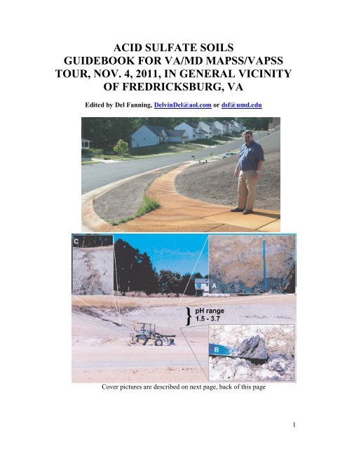
Cover pictures are described on next page, back <strong>of</strong> this page<br />
1
Cover Pictures:<br />
Top: Dr. W. Lee Daniels, Thomas B. Hutcheson, Jr. Pr<strong>of</strong>essor <strong>of</strong> Environmental Soil<br />
Science at Virginia Tech, stands on iron oxides stained concrete <strong>of</strong> sidewalk at the Great<br />
Oaks development in Fredericksburg, VA in November, 2005. The yard surrounding the<br />
sidewalk was un-vegetated, in spite <strong>of</strong> sod being laid on the active acid sulfate soil <strong>of</strong> the<br />
yard at this site more than once -- although grass was growing along the down slope edge<br />
<strong>of</strong> the concrete – probably because <strong>of</strong> neutralization <strong>of</strong> waters carrying the iron released<br />
by acid sulfate weathering from the soil by the concrete. Lee is a main organizer and a<br />
presenter at this acid sulfate soils conference. A drive by <strong>of</strong> this and other yards at Great<br />
Oaks, most <strong>of</strong> which were remedied by heavy lime additions, is planned for this tour,<br />
time permitting, and a write-up about Great Oaks from the field trip guidebook for the<br />
acid sulfate soils tour that took place in 2006 (Fanning 2006) is in this guidebook, see<br />
pages 21-24.<br />
Bottom: a collage <strong>of</strong> pictures reproduced from Fig. 3 <strong>of</strong> Fanning et al. (2004) showing<br />
scalped land surface along the north perimeter <strong>of</strong> Stafford County Regional Airport<br />
grounds after a long dry weather spell in October, 2001, during construction <strong>of</strong> the<br />
airport. The brown oxidized zone at the top <strong>of</strong> the slope clearly stands out above the<br />
white, salt covered, lower scalped surface where some pH’s were less than 2. Inset<br />
pictures show A – exposed contact between the oxidized (brownish) and unoxidized<br />
(dark bluish gray) zones, which occurred about 3.5 meters below the natural, pre-scalping<br />
surface <strong>of</strong> the hill: B – Exposed platy soil structure with plate surfaces parallel to the<br />
scalped land surface. The structure is considered to have formed after the scalped land<br />
surface came into existence. The newly formed mineral jarosite, indicative in<br />
combination with ultra low pH <strong>of</strong> a sulfuric horizon by Soil Taxonomy, was found on<br />
some <strong>of</strong> the plate surfaces. C – Small rivulet, spring, that emanated from along the top <strong>of</strong><br />
the unoxidized zone in low spot in natural surface topography, showing newly formed<br />
iron (hydr)oxides in the drainage way.from the acid drainage waters. The salts on the<br />
surface were identified as halotrychite, a highly hydrated ferrous iron aluminum sulfate<br />
mineral for the white salt covering the bulk <strong>of</strong> the surface <strong>of</strong> the previous unoxidized<br />
zone, and aluminocopiapite, a highly hydrated aluminum ferric iron hydroxy sulfate<br />
mineral for some lemon yellow salts that occurred along the rivulet. We will be<br />
examining soil pr<strong>of</strong>iles along the now largely vegetated slope during the field trip on<br />
Nov. 4, 2011.<br />
References:<br />
Fanning, D. S. (Tour Leader, Guidebook Editor). 2006. Acid sulfate soils <strong>of</strong> the U.S.<br />
Mid-Atlantic/Chesapeake Bay Region. Guidebook for tour, July 6-8, 2006 for 18 th World<br />
Congress <strong>of</strong> Soil Science. <strong>University</strong> <strong>of</strong> <strong>Maryland</strong>, College Park, MD.<br />
http://www.sawgal.<strong>umd</strong>.<strong>edu</strong>/MAPSS/WCSS_Guidebook.pdf<br />
Fanning, D. S., Cary Coppock, Z. W. Orndorff, W. L. Daniels, and M. C. Rabenhorst.<br />
2004. Upland active acid sulfate soils from construction <strong>of</strong> new Stafford County,<br />
Virginia, USA, Airport. Australian J. Soil Research 42: 527-536.<br />
2
TABLE OF CONTENTS<br />
Cover with explanation <strong>of</strong> cover pictures. Pages 1 and 2<br />
Table <strong>of</strong> Contents. This page. Page 3.<br />
Overall Introduction. Page 4.<br />
STOP 1, SRAP, Stafford County, VA, Regional Airport. Pages 5-20.<br />
STOP 2, Great Oaks Development in Fredericksburg, VA, Pages 21-24.<br />
STOP 3, Captain Billy’s Restaurant, Pope’s Creek, MD, Page 25.<br />
STOP 4, Loyola Retreat House, Faulkner, MD, where the cliff face on the Potomac<br />
River, with acid sulfate weathering features and a Native American oyster shell<br />
kitchen midden, will be examined. Pages 26-41.<br />
Tour Roadlog, Pages 41-42<br />
Acknowledgements, Page 43<br />
3
OVERALL INTRODUCTION<br />
This tour will have only four main stops, one <strong>of</strong> which will be for lunch, however, this tour<br />
guidebook is quite long, taking advantage <strong>of</strong> the tour guide prepared for the WCSS (World<br />
Congress <strong>of</strong> Soil Science) acid sulfate soils tour <strong>of</strong> July, 2006, from which much material for the<br />
stops <strong>of</strong> this trip are reproduced in this 2011 guidebook. A road log guide for this trip has at the<br />
last minute been produced, see pages 41-42.<br />
A main goal <strong>of</strong> the trip is to show the oxidized and unoxidized zones <strong>of</strong> the soil geologic column<br />
at Stop 1 SRAP (the Stafford County, VA Regional Airport) and at Stop 4 (the cliff on the<br />
Potomac River at the Loyola Retreat House) and some <strong>of</strong> the consequences in terms <strong>of</strong> the<br />
formation <strong>of</strong> active acid sulfate soils at Stops 1 and 2 (the Great Oaks development) in<br />
Fredericksburg. We considered an additional stop at the huge road cut with active acid sulfate<br />
soils in the Quantico Slate on Mine Road near Garrisonville, VA, but time-distance won’t permit<br />
us to visit that site. For those with an interest in that site, there are information and pictures<br />
available in the WCSS tour guidebook (Fanning, 2006), which is available on the MAPSS web<br />
site. Another site that would have been good to visit on this tour is the Carriage Hills<br />
development in Falmouth, VA, just north <strong>of</strong>, but outside the city limits <strong>of</strong> Fredericksburg. Much<br />
disturbance <strong>of</strong> sulfidic materials occurred there with active acid sulfate soils brought into<br />
existence in new home owner’s yards after the time <strong>of</strong> the WCSS tour. Information about some<br />
<strong>of</strong> the Carriage Hills acid sulfate soils situations appear in an article by Fanning and others in the<br />
Summer 09 issue <strong>of</strong> Pedologue, the MAPSS Newsletter, see reference below, which also is<br />
available on the MAPSS web site. Many <strong>of</strong> the yards at Carriage Hills were remedied thru<br />
assistance from Dr. Daniels and his team at VT and the builders at Carriage Hills with assistance<br />
from Stafford County environmental authorities to get them to do it. Those who are interested are<br />
invited to look at these publications available from the web site as cited below.<br />
Archeologists have become very interested in the oyster shell kitchen midden at Stop 4 and have<br />
helped us to gather more information about the midden for this tour, for which we owe them a big<br />
debt <strong>of</strong> gratitude.<br />
References:<br />
Fanning, D. S. (Tour Leader, Guidebook Editor). 2006. Acid sulfate soils <strong>of</strong> the U.S. Mid-<br />
Atlantic/Chesapeake Bay Region. Guidebook for tour, July 6-8, 2006 for 18 th World Congress <strong>of</strong><br />
Soil Science. <strong>University</strong> <strong>of</strong> <strong>Maryland</strong>, College Park, MD.<br />
http://www.sawgal.<strong>umd</strong>.<strong>edu</strong>/MAPSS/WCSS_Guidebook.pdf<br />
Fanning, Delvin S., Philip K. Zurheide, and W. Lee Daniels. 2009. Active acid sulfate soils in<br />
yards <strong>of</strong> homes in new housing development at the Carriage Hills Development at Falls Run in<br />
Stafford County, VA – recognized by homeowners, with an assist from Dig It, the soils exhibit at<br />
Smithsonian Museum <strong>of</strong> Natural History. The saga goes on. Pedologue, Summer 2009 Issue.<br />
http://www.sawgal.<strong>umd</strong>.<strong>edu</strong>/mapss/Pedologue/PEDOLOGUE_2009Summer.pdf<br />
4
STOP 1<br />
SRAP<br />
STAFFORD COUNTY, VA REGIONAL<br />
AIRPORT<br />
The bulk <strong>of</strong> the printed materials for this stop, pages 7-20,<br />
were prepared for the July 8, 2006, World Congress <strong>of</strong> Soil<br />
Science Tour <strong>of</strong> Acid Sulfate Soils <strong>of</strong> the Mid-Atlantic<br />
Chesapeake Bay Region (Fanning, 2006) – see full reference on<br />
the back <strong>of</strong> the cover page for this 2011 tour. However,<br />
descriptions <strong>of</strong> pr<strong>of</strong>iles made in two new soil pits for this 2011<br />
tour appear at the end <strong>of</strong> the printed materials for this stop,<br />
pages 15-20.<br />
5
STOP 1 AND BEGINNING AND END OF THE TOUR<br />
STAFFORD COUNTY, VA REGIONAL AIRPORT, SRAP<br />
There are broad areas <strong>of</strong> active acid sulfate soils, mostly Sulfaquepts or Sulfudepts<br />
by Soil Taxonomy, at SRAP. Had acid sulfate soil principles been employed by<br />
engineers who constructed the airport, around the year 2000, sulfidic materials<br />
should not have been exposed to oxidation and active acid sulfate soils should not<br />
have formed. As explained by Fanning et al. (2004) in their paper about the acid<br />
sulfate soils at SRAP, the engineers in charge <strong>of</strong> the construction claimed ignorance<br />
<strong>of</strong> knowledge about acid sulfate soils. Active acid sulfate soils formed in a few weeks<br />
or months on sulfidic materials (potential acid sulfate soil materials in general<br />
terminology) that were exposed -- both on scalped land surfaces (cuts in engineering<br />
parlance) and on the spoil that was employed to make the flat land for runways etc.<br />
and on the excess spoil which was piled to make new hills in the northeast corner <strong>of</strong><br />
the airport. Soil scientists now employ the soils at the airport to <strong>edu</strong>cate people<br />
about the nature <strong>of</strong> acid sulfate soils and the need to employ sound principles in<br />
future land disturbance activities to prevent the problems associated with active<br />
acid sulfate soils from arising. Also ways <strong>of</strong> remedying and reclaiming lands where<br />
active acid sulfate soils have been bought into existence have been employed and<br />
studied here, particularly by Virginia Tech soil scientists/reclamation experts. As<br />
soil scientists we are disappointed that the lessons pertaining to the dangers <strong>of</strong><br />
bringing active acid sulfate soils into existence by deep land disturbance,<br />
experienced at SRAP, have not been better learned and employed by community<br />
leaders so as to prevent active acid sulfate soils from coming into existence in<br />
developments such as at Great Oaks in Fredericksburg and Carriage Hills in<br />
Stafford County, and many other places, in the times since SRAP was constructed.<br />
We’ll just have to keep sounding <strong>of</strong>f.<br />
The bulk <strong>of</strong> the information about acid sulfate soils at SRAP was collected and put<br />
into the guidebook for acid sulfate soils tour for the 2006 WCSS (World Congress <strong>of</strong><br />
Soil Science) (Fanning, 2006). The pages <strong>of</strong> that guidebook pertaining to the airport<br />
are reproduced on succeeding pages, pages 7- 14. Following that, in this guidebook,<br />
pages 15-20, there are descriptions <strong>of</strong> two pr<strong>of</strong>iles for which backhoe trenches were<br />
opened for us at the airport by Ed Wallis, Airport Manager, for this trip. One <strong>of</strong><br />
these descriptions is for a pr<strong>of</strong>ile at the boundary between the oxidized and<br />
unoxidized zones along the slope and the other for more clay rich and rock like soil<br />
near the bottom <strong>of</strong> the slope.<br />
If time permits we also hope to show <strong>of</strong>f a relatively undisturbed soil in the oxidized<br />
zone and an active acid sulfate soil in spoil at SRAP, and there is a “Badlands area<br />
with gullies and no vegetation a bit to the west <strong>of</strong> where the soil pits mentioned<br />
above are located. The tour group may be split into two groups to see stuff around<br />
other parts <strong>of</strong> the airport – tour around to probably be led by Lee, Zenah and Ed<br />
Wallis.<br />
6
Fanning’s preliminary comments: (this section reproduced from Fanning, 2006)<br />
This stop will be at the Stafford County, VA, Regional Airport where large areas <strong>of</strong><br />
sulfidic materials were exposed on scalped land surfaces and as spoil during the<br />
construction <strong>of</strong> the airport, which opened in 2002. Virginia Tech (Orndorff and Daniels)<br />
and <strong>University</strong> <strong>of</strong> <strong>Maryland</strong> (Fanning, Coppock, Rabenhorst) soil scientists have<br />
collaborated to document information on the soils, water quality and corrosion etc. at this<br />
site and Virginia Tech developed a reclamation plan that utilized heavy applications <strong>of</strong><br />
lime-stabilized biosolids (sewage sludge) and acid and salt tolerant grass species (e.g.<br />
hard fescue) to establish vegetation on the soils <strong>of</strong> the site, most <strong>of</strong> which were active<br />
acid sulfate soils with a sulfuric horizon by Soil Taxonomy right at the surface <strong>of</strong> the<br />
soils.<br />
Results <strong>of</strong> our early (2001-2003) scientific efforts at this site and background information<br />
about the airport and its construction are covered in a joint paper presented at the 5 th<br />
International Acid Sulfate Soils Conference in Australia in 2002 (Fanning et al. 2004 –<br />
see citation at the end <strong>of</strong> the soil description and data for a soil on the scalped soil surface<br />
at this site below). To save space in what we write here, reprints <strong>of</strong> the paper will be<br />
given out to trip participants. The leaders <strong>of</strong> the trip would be pleased to receive these<br />
reprints back after participants have looked at the paper, however, these can be taken as a<br />
souvenir <strong>of</strong> this trip etc. if so desired. What we are giving out essentially exhausts our<br />
supply <strong>of</strong> the reprints – that’s why we ask for them back if you don’t have a good use for<br />
them. Documentation for much <strong>of</strong> what we say at this site is in the (reprint) paper.<br />
Our planned activities for this site are to stop at the airport hangar to pick up Dr. Zenah<br />
Orndorff and Ed Wallis, Airport Manager, and to give those who need it the opportunity<br />
to use the rest rooms in the hangar. We will then proceed to examine the soil on the<br />
scalped land surface, described below, and to discuss this soil and how it developed with<br />
reference back to the paper mentioned above. If available, we may also examine a soil in<br />
spoil on flatter ground. We then plan to drive our tour group in the bus around the airport<br />
to the southwest side for a short stop and talks there. There may be opportunities for<br />
examination <strong>of</strong> some <strong>of</strong> the concrete and metal corrosion caused by waters that have<br />
seeped and flowed out <strong>of</strong> the soils. Somewhere along the way, Zenah will comment on<br />
the water quality in stream water as affected by the airport construction and the use <strong>of</strong> the<br />
biosolids in the reclamation efforts.<br />
Orndorff preliminary comments Construction <strong>of</strong> SRAP in the late 1990’s exposed over<br />
150 ha <strong>of</strong> lower Tertiary age Coastal Plain materials as the airport runway was<br />
constructed through a deeply dissected landscape. As construction proceeded, long spur<br />
ridges were excavated to depths > 25 m, exposing significant volumes <strong>of</strong> gray, r<strong>edu</strong>ced,<br />
sulfidic (0.6 to 1.2 % pyritic-S; PPA up to 60 Mg CaCO 3 /1000 Mg material) silty<br />
sediments, which were subsequently filled into intervening valley fills to support the ><br />
1500 m runway. Excavated sulfidic materials exceeded the capacity <strong>of</strong> the valley fills and<br />
were also placed into several large, steeply sloping excess spoil fills along a first-order<br />
stream draining the eastern section <strong>of</strong> the site. Due to the fact that the sulfidic nature <strong>of</strong><br />
these materials was not recognized until well after all final grading was completed, the<br />
acid-forming materials were not isolated away from drainage, and in fact were essentially<br />
7
scattered randomly, and thoroughly, throughout the site. Reclamation efforts over the past<br />
four years have been highly successful (> 90% <strong>of</strong> area is revegetated), although discrete<br />
problematic areas still exist throughout the airport. More detailed information regarding<br />
the soils and reclamation <strong>of</strong> SRAP is provided in Fanning et.al (2004) and an updated<br />
table <strong>of</strong> water quality data is provided on a subsequent page.. Provided on this page are<br />
pictures to show some<br />
<strong>of</strong> the metal and<br />
concrete corrosion at<br />
SRAP. The first<br />
picture shows drain<br />
pipes from a sediment<br />
control pond on the<br />
south side <strong>of</strong> the<br />
airport where the<br />
pipes have been eaten<br />
thru by the acidic<br />
waters. This picture<br />
was taken by Dr.<br />
Daniels <strong>of</strong> Virginia<br />
Tech. The picture at<br />
the bottom <strong>of</strong> the<br />
page, also from Dr.<br />
Daniels, shows<br />
concrete corrosion and iron staining in a “protected” channel on the north side <strong>of</strong> the<br />
airport.<br />
8
Description <strong>of</strong> Soil on Scalped Land Surface at Stafford Co., VA, Regional Airport<br />
Developed in Sandy Sulfidic Tertiary Geologic Sediments<br />
Pr<strong>of</strong>ile:<br />
Oe: 0-5cm; Dark reddish brown (5YR 3/3) “Peaty” material that is essentially a root mat<br />
<strong>of</strong> many very fine roots <strong>of</strong> hard fescue (planted in 2002) and broom sedge. The earthy<br />
material that constitutes this horizon was apparently applied to the soil as biosolids<br />
(sewage sludge). It contains some admixed mineral soil material that probably became<br />
part <strong>of</strong> the horizon by mixing when the sludge amendment was applied to the soil.<br />
Friable moist; pH 3.01. abrupt, smooth boundary.<br />
BAj: 5-10cm; Olive gray (5Y4/2) with common (
Fanning’s comment in reply to Sparrgaren was to the effect that the low chroma colors<br />
are from geologic gleying <strong>of</strong> the parent material, thus the assignment <strong>of</strong> Cg horizon<br />
symbols. Fanning thinks that a thionic modifier is needed by WRB for this soil. This<br />
soil is similar to the one on the scalped surface at Stop 3. If an engineering cut into<br />
sulfidic materials is made, as was the case here, a sulfuric horizon can form within a few<br />
months, as here. In Soil Taxonomy this immediately advances the soil from being an<br />
Entisol (Sulfaquent) to an Inceptisol. There are big pedogenic changes in the chemistry,<br />
and in S mineralogy (mineral transformations), as well as in the physical properties <strong>of</strong> the<br />
zone in which the sulfuric horizon has formed – this is “big bang” soil genesis.<br />
Described and sampled on Nov. 17 and 19, 2005 by D. S. Fanning, Department <strong>of</strong><br />
Natural Resource Sciences and Landscape Architecture, <strong>University</strong> <strong>of</strong> <strong>Maryland</strong>, College<br />
Park, MD 20742-4452. Telephone: Office: 301-405-1308, Home: 301:864-5561. e-mail:<br />
dsf@<strong>umd</strong>.<strong>edu</strong> or DelvinDel@aol.com<br />
Area: Stafford County, VA.<br />
Location: Near middle <strong>of</strong> cut slope on N side <strong>of</strong> Airport, down from former engineering<br />
headquarters.<br />
Vegetation: Hard fescue and some broom sedge.<br />
Parent material: Very fine sand sulfidic Tertiary sediments that were in the unoxidized<br />
zone <strong>of</strong> the soil-geologic column until exposed by construction activities during the<br />
construction <strong>of</strong> the airport.<br />
Physiography – Geomorphology: Human-made slope (scalped land surface by<br />
terminology <strong>of</strong> Fanning and Fanning, 1989, textbook) in dissected Upper Coastal Plain<br />
uplands. The scalped land surface was made during the airport construction activities in<br />
about the year 2000.<br />
Slope and Aspect: About 25% smooth slope facing south.<br />
Erosion: The soil was described in the west wall <strong>of</strong> a shallow gully that has formed since<br />
the slope was made by construction in about 2001.<br />
Moisture condition when described: The soil was moist throughout. The description was<br />
made during cool weather with day time highs about 50 degrees F.<br />
Additional Notes: The faces <strong>of</strong> the platy structure in the BA and Bwj horizons are mostly<br />
covered with jarosite. The plate faces are roughly parallel to the soil surface. This<br />
demonstrates that the platy structure formed on the new, human-constructed, land surface<br />
and that the jarosite formed after the land surface was constructed. There are some fine,<br />
sand-size lignite grains/chips in the Cg horizons that appear to constitute about 5% <strong>of</strong> the<br />
sand <strong>of</strong> these horizons. Pictures <strong>of</strong> pr<strong>of</strong>ile and landscapes follow.<br />
10
The depth increments on the tape over pr<strong>of</strong>ile are 10cm (about 4 inches) apart.<br />
11
These pictures taken in November, 2005, may be compared to the pictures <strong>of</strong> this slope<br />
when it was covered with salts etc. and not vegetated in 2001, shortly after airport<br />
construction as given in the paper by Fanning et al. (2004). For some lab data for the<br />
pr<strong>of</strong>ile, see the next page. The top picture is a close up <strong>of</strong> the pr<strong>of</strong>ile sampling site, the<br />
bottom is the full slope.<br />
12
Some data for total S, C, and N contents determined with a CNS analyzer at the NRCS<br />
National Soil Survey Lab on air-dry, less than 2 mm soil material, for this pr<strong>of</strong>ile from<br />
the Stafford Regional Airport are given below.<br />
Horizon Depth (cm) Total S (%) Total C ((%) Total N (%)<br />
Oe 0-5 0.27 2.77 0.332<br />
BAj 5-10 0.13 0.32 0.092<br />
Bwj 10-20 1.42 0.30 0.092<br />
Cg1 20-35 0.42 0.39 0.062<br />
Below: Incubation data <strong>of</strong> duplicate samples <strong>of</strong> the Cg2 horizon soil materials that show<br />
that this horizon qualifies as a sulfidic material by Soil Taxonomy. Dates are in 2006.<br />
Note that the pH had already dropped from 4.29 when the sample was collected in<br />
November, 2005, until the time the incubation was started in February 2006.<br />
Sample Depthcmetc. 2/15 2/22 3/1 3/9 3/16 3/23 3/30 4/6 4/13<br />
SRAP Cg2, 1 3.69 3.49 3.19 3.02 2.52 2.73 2.47 2.31 2.12<br />
SRAP Cg2, 2 3.73 3.48 3.05 3.02 2.62 2.75 2.44 2.33 2.06<br />
References:<br />
Fanning, D. S. and M. C. B. Fanning. 1989. Soil: Morphology, Genesis, and<br />
Classification. John Wiley and Sons, New York. 395 pages.<br />
Fanning, D. S., Cary Coppock, Z. W. Orndorff, W. L. Daniels, and M. C. Rabenhorst.<br />
2004. Upland active acid sulfate soils from construction <strong>of</strong> new Stafford County,<br />
Virginia, USA, Airport. Austrlian J. Soil Research 42: 527-536.<br />
13
The table below repeats data given in Table 1 <strong>of</strong> Fanning et al. (2004) and gives some<br />
additional data from more recent dates (Sep-03, Sep-05 and Mar-06).<br />
dS/m -----------------------mg/L----------------------<br />
Location Date pH EC Fe Al S NH3-N NO3-N<br />
SW 4 Apr-02 5.12 121 6.1 0.5 2 ND 0.09<br />
(Above site) Jun-02 5.75 93 6.8 0.1 1 0.52 0.29<br />
Nov-02 4.69 636 0.6 0.3 6 0.32 0.41<br />
Sep-03 5.29 201 1.7 0.1 2 0.28 1.38<br />
Sep-05 ND ND ND ND ND ND ND<br />
Mar-06 ND ND ND ND ND ND ND<br />
SW 1 Feb-02 3.18 816 42.0 12.0 107 ND ND<br />
(In Site) Apr-02 2.93 1489 62.0 25.0 195 0.74 0.02<br />
Jun-02 2.92 2080 67.0 7.0 294 46.20 0.69<br />
Nov-02 3.49 1496 34.0 17.0 252 3.95 8.69<br />
Sep-03 3.49 646 8.2 2.1 77 1.21 0.88<br />
Sep-05 6.31 230 14.5 0.1 21 0.17 0.19<br />
Mar-06 4.28 142 2.8 2.3 35 0.00 0.14<br />
SW 6 Apr-02 3.30 1267 42.0 18.0 147 0.88 ND<br />
(Below Site) Jun-02 6.32 728 44.0 0.7 66 16.10 0.12<br />
Nov-02 4.20 143 19.0 10.0 136 2.36 4.79<br />
Sep-03 4.39 515 0.5 2.8 70 0.86 1.55<br />
Sep-05 6.72 431 8.4 1.3 17 0.08 0.10<br />
Mar-06 4.80 315 2.9 3.7 36 0.12 0.42<br />
SW 7<br />
May-<br />
02 5.48 58 2.9 0.2 5 0.13 0.05<br />
(Above Site) Jun-02 6.60 56 2.4 ND 3 0.43 0.04<br />
Nov-02 5.01 96 1.7 0.1 8 0.84 0.89<br />
Sep-03 5.94 206 1.2 0.1 4 0.13 0.88<br />
Sep-05 6.56 48 2.2 0.1 2 0.00 0.04<br />
Mar-06 5.35 63 0.5 0.1 5 0.02 0.15<br />
NRCS Dam Mar-02 3.30 590 8.7 7.7 61 0.14 0.36<br />
May-<br />
(Below Site) 02 5.97 535 7.4 0.2 66 17.32 0.90<br />
Jun-02 7.37 531 0.8 ND 57 18.34 0.08<br />
Nov-02 5.23 962 0.3 1.0 138 1.86 12.80<br />
Sep-03 7.03 406 0.9 0.1 43 0.23 1.66<br />
Sep-05 6.30 132 1.1 0.1 10 0.00 0.10<br />
Mar-06 5.92 122 0.8 0.1 12 0.00 0.04<br />
14
SOIL DESCRIBED IN NEW UPSLOPE PIT, REFERRED TO AS PIT 1, FOR<br />
VAPSS/MAPSS <strong>ACID</strong> <strong>SULFATE</strong> <strong>SOILS</strong> TOUR ON NOV. 4, 2011. THIS PIT<br />
WAS DUG ACROSS THE BOUNDARY OF WHERE THE UPPER PART OF<br />
THE SOIL PROFILE EXPOSED IS IN THE OXIDIZED ZONE OF THE SOIL-<br />
GEOLOGIC COLUMN AND WHERE DOWNSLOPE THE OXIDIZED ZONE<br />
WAS COMPLETELY SCALPED AWAY DURING AIRPORT CONSTRUCTION,<br />
SUCH THAT THE NEW SOIL, FOLLOWING THE SCALPING IS IN THE<br />
UNOXIDIZED ZONE OF THE ORIGINAL SOIL-GEOLOGIC COLUMN.<br />
Description <strong>of</strong> soil pr<strong>of</strong>ile on scalped land surface at Stafford Co., VA, Regional<br />
Airport. This pr<strong>of</strong>ile is developed in very fine sand sulfidic Tertiary Geologic<br />
Sediments. It was described in a new backhoe pit, opened Oct. 3. 2011 by Ed Wallis,<br />
for VAPSS/MAPSS acid sulfate soils workshop tour Nov. 4, 2011. The pr<strong>of</strong>ile was<br />
described on the land surface about 2 meters upslope from the boundary between<br />
the oxidized zone and the unoxidized zone on the scalped land surface.<br />
Pr<strong>of</strong>ile:<br />
A: 0-7cm; dark reddish brown (5YR 3/3) silt loam that is essentially a root mat <strong>of</strong><br />
many fine and very fine roots <strong>of</strong> grass, hard fescue, planted in 2002 after limestabilized<br />
biosolids (sewage sludge) were added and mixed into this soil that was<br />
previously unvegetated on a scalped land surface; moderate to strong, very fine and<br />
fine granular structure; friable; pH 8.1, apparently reflecting presence <strong>of</strong> calcium<br />
carbonate, probably formed from burned-slaked lime <strong>of</strong> the biosolids; abrupt,<br />
smooth boundary.<br />
Bw: 6-31cm; strong brown (7.5YR 5/8), with common, fine, distinct 7.5YR 5/3 redox<br />
depletions, especially in the lower part; very fine sandy loam with weak, fine,<br />
subangular blocky structure with a tendency to weak medium platy primary<br />
structure in the lower part; very friable; pH 5.67; common very fine and few fine<br />
roots in upper half, but few roots <strong>of</strong> any kind below; abrupt, smooth boundary that<br />
dips into the hill upslope <strong>of</strong> the pr<strong>of</strong>ile. This horizon becomes thicker upslope and<br />
gets thinner down slope until it is absent about 2 meters down the slope where this<br />
horizon that represents the lower part <strong>of</strong> the oxidized zone <strong>of</strong> the original (predisturbance<br />
oxidized zone) soil geologic column is no longer present.<br />
Bwj: 31-54cm; brown (5YR 5/2) in upper part grading to dark grayish brown<br />
(10YR 4/2) matrix in lower part with common fine (but elongated laterally along<br />
faces <strong>of</strong> weak platy structure) prominent 5Y 7/4 jarosite and 7.5YR 5/8, probable<br />
lepidocrocite, redox concentrations; very fine sandy loam; friable; pH 4.0 in upper<br />
part and 3.9 in lower part; based on chemical tests – no violent reaction with 30%<br />
hydrogen peroxide -- see notes pertaining to this pr<strong>of</strong>ile, this horizon is judged to<br />
not be a sulfuric horizon, but to be a post-active acid sulfate soil material; abrupt,<br />
irregular boundary<br />
Cgse: 54-140+cm; very dark bluish gray (5B 3/1) very fine sandy loam or perhaps<br />
loamy very fine sand; massive; friable with tendency to be firm in situ; no roots<br />
15
present; pH 4.1. Based on previous pH with incubation test and a violent reaction<br />
within about a minute after the addition <strong>of</strong> hydrogen peroxide to a sample <strong>of</strong> this<br />
soil material from a depth <strong>of</strong> about 80cm with 30% hydrogen peroxide, this soil<br />
material qualifies as a sulfidic material by Soil Taxonomy.<br />
Described Oct. 4, 2011 by D. S. Fanning, Department <strong>of</strong> Environmental Science and<br />
Technology, <strong>University</strong> <strong>of</strong> <strong>Maryland</strong>, College Park, MD 20742-4452. Telephone: Office:<br />
301-405-1308, Home: 301:864-5561. e-mail: dsf@<strong>umd</strong>.<strong>edu</strong> or DelvinDel@aol.com A<br />
picture <strong>of</strong> the pr<strong>of</strong>ile appears on the next page.<br />
Classification: As described this soil does not have a sulfuric horizon occurring above a<br />
depth <strong>of</strong> 50cm, thus it does not qualify as a Sulfaquept or a Sulfudept, however, it does<br />
have sulfidic materials occurring at a depth <strong>of</strong> 54cm and below, thus the soil should<br />
qualify for a Sulfic subgroup as that subgroup is recognized elsewhere in Soil Taxonomy.<br />
If a cambic horizon is recognized for the Bw horizon, the soil should qualify as a<br />
Dystrudept, if a cambic horizon is not recognized, the soil should qualify as a Udorthent.<br />
A Scalpic subgroup, to recognize that the soil is on a scalped land surface would be<br />
recommended by the system for highly human-influenced soils by Fanning and Fanning<br />
(1989). The family classification remains to be worked out.<br />
Note that the soil as described is <strong>of</strong> very minor extent, it occurs on the boundary between<br />
the Sulfudepts/Sulfaquepts downslope and the Dystrudepts/Udorthents upslope.<br />
Area: At Stafford County, VA, Regional Airport, Stafford County, VA.<br />
Location: Middle to upper part <strong>of</strong> cut slope on N side <strong>of</strong> Airport, down from former<br />
engineering headquarters. GPS coordinates need to be obtained.<br />
Vegetation: Hard fescue and some broom sedge and other plants, trees invading.<br />
Parent material: Very fine sand sulfidic Tertiary sediments <strong>of</strong> which the upper part were<br />
in the oxidized zone and the lower part in the unoxidized zone <strong>of</strong> the soil-geologic<br />
column until exposed by construction activities during the construction <strong>of</strong> the airport.<br />
Physiography – Geomorphology: Human-made slope (scalped land surface by<br />
terminology <strong>of</strong> Fanning and Fanning, 1989, textbook) in dissected Upper Coastal Plain<br />
uplands. The scalped land surface was made during the airport construction activities in<br />
about the year 2000.<br />
Slope and Aspect: About 25% up slope and 20% down slope on generally smooth southfacing<br />
slope.<br />
Erosion: There was no evidence <strong>of</strong> erosion since the slope was constructed where this<br />
pr<strong>of</strong>ile was described,<br />
Moisture condition when described: The soil was moist throughout.<br />
16
A picture <strong>of</strong> the soil pr<strong>of</strong>ile described on the previous two pages. Note that the thickness<br />
<strong>of</strong> the stong brown Bw horizon increases upslope to the right and decreases downslope to<br />
the left. The textures <strong>of</strong> the various horizons was similar, indicating that the upper<br />
horizons developed from material like the sulfidic materials <strong>of</strong> the Cgse horizon at the<br />
bottom <strong>of</strong> the pr<strong>of</strong>ile. The brown spots at the top <strong>of</strong> the Cgse horizon are contamination<br />
<strong>of</strong> materials fallen from above – the pr<strong>of</strong>ile should have been cleaned better prior to<br />
photography. Picture taken by D. S. Fanning, Oct. 4, 2011.<br />
17
Description <strong>of</strong> soil pr<strong>of</strong>ile (SRAP pit 2 for Nov. 4, 2011 field trip) on lower slope <strong>of</strong><br />
scalped land surface at Stafford Co., VA, Regional Airport. This pr<strong>of</strong>ile is<br />
developed in clayey Tertiary or Upper Cretaceous Geologic Sediments, which have<br />
essentially hardened (possibly in part after exposure by landscape scalping) to a<br />
rock-like (shale) material. It was described in new a new backhoe pit opened Oct.<br />
3. 2011, by Ed Wallis, SRAP Manager for VAPSS/MAPSS acid sulfate soils<br />
workshop tour Nov. 4, 2011.<br />
Pr<strong>of</strong>ile:<br />
A or Oe: 0-5cm; dark reddish brown (5YR 3/3) peaty silt loam that is essentially a<br />
root mat <strong>of</strong> fine and very fine roots <strong>of</strong> grass, presumably hard fescue; moderate to<br />
strong , very fine, granular structure; very friable; pH 7.6; abrupt, smooth<br />
boundary. The high pH <strong>of</strong> this and the AB horizon below are from the<br />
incorporation <strong>of</strong> lime-stabilized biosolids in 2001-2002 to enable plant growth on<br />
this soil.<br />
AB: 5-11cm; dark reddish brown (5YR 3/4) sandy loam; strong, very fine, granular<br />
structure; very friable; pH 7.6: abrupt, wavy boundary.<br />
Bwj 1: 11-30cm; reddish brown (2.5YR 4/6) and dark gray (7.5YR 4/1), with more<br />
<strong>of</strong> the red colors in the lower part and more gray in the upper part, silty clay loam;<br />
structure and consistence not described, but appears blocky in pr<strong>of</strong>ile picture, see<br />
succeeding page, and was likely friable; some jarosite concentrations seen in some<br />
places; common fine and very fine roots in upper part grading to none in lower<br />
part; pH 3.3; clear, irregular boundary.<br />
Bwj 2: 30-50cm; similar to Bwj1, but with more <strong>of</strong> the grayer colors and with gray<br />
interior <strong>of</strong> stones, which occupy sufficient, greater than 15% <strong>of</strong> volume, to justify a<br />
stony modifier on textural class, thus stony silty clay loam texture. The stones have<br />
red iron oxides and jarosite on some <strong>of</strong> their faces; pH 3.2; abrupt, irregular<br />
boundary<br />
Rgse; 50 cm to bottom <strong>of</strong> pit at about 1 meter depth; dark greenish gray (10G 4/1)<br />
rock that tends to break down to silty clay loam like materials <strong>of</strong> Bwj horizons;<br />
strong, very coarse prismatic structure, but prisms are crude – not nice vertical<br />
fractures between them, with reddish brown iron oxides and jarosite, 2.5Y-5Y 8/4.<br />
on fracture faces in at least the upper part <strong>of</strong> this layer which was broken up by<br />
back hoe digging the pit – this material would be very difficult to dig by hand with a<br />
spade/shovel; pH about 5 in gray interior <strong>of</strong> rock measured with bromcresol green<br />
indicator, but pH is 4 or less on fracture faces – the pH <strong>of</strong> some <strong>of</strong> the crushed rock<br />
measure in laboratory with glass electrode was 4.1. This material carries down<br />
below the bottom <strong>of</strong> the pit. Some <strong>of</strong> the material gave a violent, heat-producing<br />
reaction with 30% hydrogen peroxide, but it took about 10 minutes for the reaction<br />
to “take <strong>of</strong>f”, slowness thought to be because <strong>of</strong> the low amount <strong>of</strong> surface area for<br />
18
eaction. This material is considered to qualify as a sulfidic material by Soil<br />
Taxonomy.<br />
Described Oct. 3, 2011 by D. S. Fanning, Department <strong>of</strong> Environmental Science and<br />
Technology, <strong>University</strong> <strong>of</strong> <strong>Maryland</strong>, College Park, MD 20742-4452. Telephone: Office:<br />
301-405-1308, Home: 301:864-5561. e-mail: dsf@<strong>umd</strong>.<strong>edu</strong> or DelvinDel@aol.com .<br />
Fanning was assisted by Matt Salos, chair <strong>of</strong> the Cheverly, MD green infrastructure<br />
science advisory committee, who took the picture <strong>of</strong> the pr<strong>of</strong>ile <strong>of</strong> this soil that appears<br />
on the next page.<br />
Classification: The Bwj horizons, 11-50 cm depth, qualify as a sulfuric horizon by Soil<br />
Taxonomy. Since the upper boundary <strong>of</strong> this sulfuric horizon occurs above a depth <strong>of</strong><br />
50cm the soil is a Sulfaquept or a Sulfudept by Soil Taxonomy. A Scalpic subgroup (not<br />
presently recognized as an <strong>of</strong>ficial subgroup by Soil Taxonomy) to recognize that the soil<br />
is on a scalped land surface would be recommended by the system for highly humaninfluenced<br />
soils proposed by Fanning and Fanning (1989, Chapter 24, page 197). The<br />
family classification remains to be worked out.<br />
Area: At Stafford County, VA, Regional Airport, Stafford County, VA.<br />
Location: Low part <strong>of</strong> cut slope on N side <strong>of</strong> Airport, down from former engineering<br />
headquarters. GPS coordinates need to be obtained. The pit for this pr<strong>of</strong>ile is about 50<br />
feet, 15+ meters, upslope from the concrete gutter at the boundary to the flat land <strong>of</strong> the<br />
airport at the base <strong>of</strong> the slope.<br />
Vegetation: Hard fescue and some broom sedge and other plants, trees invading.<br />
Parent material: Clayey, rock-like Tertiary or Upper Cretaceous sediments/sedimentary<br />
rock exposed during the construction <strong>of</strong> the airport in about the year 2000. The parent<br />
material strongly contrasts with the very fine sandy soil materials that occur at higher<br />
elevation on the slope in which the pr<strong>of</strong>ile for Pit 1 for this 2011 field trip was described<br />
and where the pr<strong>of</strong>ile that was described on the edge <strong>of</strong> a gully for the WCSS tour in<br />
2005-6. A diagram showing the sandier material higher on the slope and the more clayrich<br />
material on the lower slope constitutes Fig. 5, page 533 <strong>of</strong> the Fanning et al. (2004)<br />
paper published in the Australian Journal <strong>of</strong> Soil Science. The information for that<br />
diagram was based in information from descriptions <strong>of</strong> the surface soils across the whole<br />
slope done by Coppock and Fanning for in 2001.<br />
Physiography – Geomorphology: Human-made slope (scalped land surface by<br />
terminology <strong>of</strong> Fanning and Fanning, 1989, textbook) in dissected Upper Coastal Plain<br />
uplands. The scalped land surface was made during the airport construction activities in<br />
about the year 2000.<br />
Slope and Aspect: About 20% and smooth upslope from the pit, but less than 20% and<br />
concave down south-facing slope.<br />
19
Erosion: There has been post airport construction gully erosion on parts <strong>of</strong> the slope near<br />
where this pr<strong>of</strong>ile was described, but not at the site <strong>of</strong> this pr<strong>of</strong>ile.<br />
Moisture condition when described: The soil was moist throughout when described.<br />
Picture <strong>of</strong> pr<strong>of</strong>ile described, taken by Matt Salos, Oct. 3, 2011, the same day the pit<br />
was opened with backhoe by Ed Wallis, SRAP Manager <strong>of</strong> Pit 2 at the airport for<br />
the Nov. 4, 2011 VAPSS/MAPSS tour. The light gray clayey soil materials were<br />
rock-like (Ed’s term was non-durable stone) and when broken up and tested with<br />
30% hydrogen peroxide gave a violent heat-generating reaction, however, it took<br />
about 15 minutes for the reaction to “take <strong>of</strong>f”, probably because <strong>of</strong> low surface<br />
area available for the reaction. Fracture surfaces in this rock-like material were<br />
decorated with iron oxide and jarosite concentrations.<br />
20
STOP 2<br />
GREAT OAKS DEVELOPMENT<br />
FREDERICKSBURG, VA<br />
All <strong>of</strong> the written materials in this guidebook for this stop are from the<br />
Guidebook for the 2006 WCSS acid sulfate soils tour.<br />
21
EXTRA STOP AS FIRST STOP ON THE MORNING OF JULY 8<br />
GREAT OAKS HOUSING DEVELOPMENT IN<br />
FREDERICKSBURG, VIRGINIA<br />
THIS SECTION IS REPRODUCED FROM 2006 WCSS GUIDEBOOK<br />
This will be a short stop, for 30 minutes or less, at a new (3 years old or less)<br />
housing development called Great Oaks in Fredericksburg, VA, just before<br />
we reach interstate highway I-95 that we will take to succeeding stops as we<br />
head north toward Washington, DC.<br />
Acid sulfate problems have arisen in many housing developments in<br />
Virginia and <strong>Maryland</strong> and other states in the region. We are stopping at<br />
Great Oaks because it is very convenient to the route <strong>of</strong> our trip and because<br />
some <strong>of</strong> the problems are at a spectacular stage here at the present time.<br />
The road leading into the development along Hays Street goes past houses<br />
with no observable problems because in the construction sulfidic materials<br />
were not encountered. Here the road/street and the houses along it are on a<br />
ridge top, probably in Quaternary geologic deposits. We will turn left <strong>of</strong>f<br />
this road onto Great Oaks Lane and proceed down slope. In about 1 block<br />
we will reach Hickory Court, which goes <strong>of</strong>f to the right. It is in this<br />
neighborhood where the lawns have almost no grass, in spite <strong>of</strong> being<br />
sodded in many places with new turf two times, and the side walks in many<br />
places are coated with iron (hydr)oxides to give them a reddish/orange color<br />
-- as shown in pictures below and on the following page.<br />
Yard above had dead turf at corner <strong>of</strong> Great Oaks Lane – the street going<br />
across the picture -- and Hickory Court that leads out to the STOP sign.<br />
22
Lee Daniels, soil scientist and reclamation expert from Virginia Tech is<br />
shown standing on discolored side walk around house at the corner <strong>of</strong> Great<br />
Oaks Lane and Hickory Court. Grass is growing along the edge <strong>of</strong> the<br />
concrete probably because <strong>of</strong> the liming effect <strong>of</strong> the concrete.<br />
Dead turf on hill side coming down from house in spite <strong>of</strong> being sodded with<br />
healthy turf two times. Lee and Zenah Orndorff have worked with some<br />
home owners who had lawns looking like this one to enable the<br />
establishment <strong>of</strong> planted turf grasses as shown in two pictures from the yard<br />
<strong>of</strong> Les Hazen on the next page. About 30 tons <strong>of</strong> lime per acre and 4 inches<br />
<strong>of</strong> a compost/topsoil mix were mixed into the top 6 inches <strong>of</strong> the acid sulfate<br />
23
soil to achieve the excellent turf shown (pictures taken May 23, 2006). The<br />
adjoining yard below was also treated with the same measures.<br />
The lower picture shows a peek into the soil beneath turf in Mr. Hazen’s<br />
front yard. Mr. Hazen claims that prior to the soil reclamation treatment his<br />
yard looked like the un-reclaimed ones shown in the pictures on the previous<br />
pages. The geologic materials here are considered to be Tertiary Coastal<br />
Plain sediments like those at SRAP to be seen at Stop 5.<br />
24
.<br />
STOP 3<br />
CAPTAIN BILLY’S RESTAURANT<br />
POPE’S CREEK<br />
MARYLAND<br />
LUNCH STOP<br />
Note that the cost <strong>of</strong> lunch for those registered for this tour are included<br />
in your registration fee, including the cost <strong>of</strong> the gratuity/tip. However,<br />
if you order an alcoholic beverage, you are expected to pay for that<br />
yourself.<br />
25
STOP 4<br />
LOYOLA RETREAT HOUSE<br />
ON HILL OVERLOOKING THE<br />
POTOMAC RIVER<br />
VIEW ACROSS TO VIRGINIA,<br />
AFTER PARKING IN LOWER PARKING<br />
LOT, WE WILL PROCEED ON FOOT<br />
DOWN STEEP, GULLIED IN UPPER<br />
PART, TRAIL TO SEE NATIVE<br />
AMERICAN OYSTER SHELL KITCHEN<br />
MIDDEN AND SOIL WEATHERING PROFILE<br />
ON CLIFF FACES BY THE RIVER<br />
WATCH YOUR STEP<br />
BE EXTRA COURTEOUS AND QUIET<br />
A RETREAT IS SCHEDULED AT THE<br />
RETREAT HOUSE<br />
26
STOP 4 CLIFF ON THE POTOMAC RIVER AT LOYOLA<br />
RETREAT HOUSE AND RELATED STUFF<br />
By Del Fanning, Dan Wagner, Derrin Lowery, with much help from others<br />
ABOVE: Photo by Darrin Lowery looking to the north, <strong>of</strong> cliff face which the trail from the<br />
Retreat House leads to, which is <strong>of</strong>f the right side <strong>of</strong> the photo, where the thickest part <strong>of</strong><br />
the kitchen midden, shown in other photos for this stop, also lies. The slope <strong>of</strong> the hill <strong>of</strong> the<br />
land, on top <strong>of</strong> the cliff, leads down to close to the water <strong>of</strong> the river <strong>of</strong>f the right side <strong>of</strong> the<br />
photo. A main reason for visiting this site, from an acid sulfate soils perspective, is to see<br />
the boundary between the brown soil materials <strong>of</strong> the oxidized zone at the top <strong>of</strong> the cliff<br />
and the dark gray color <strong>of</strong> the unoxidized zone at the base <strong>of</strong> the cliff. Lateral oxidation<br />
into the unoxidized zone on the face tends to obliterate the gray colors <strong>of</strong> the unoxidized<br />
zone on the face, but the boundary is visible to trained eyes, even without scraping away the<br />
thin surficial zone, which in many places contains bitter-tasting salts, produced by the acid<br />
sulfate weathering <strong>of</strong> pyrite <strong>of</strong> the unoxidized zone. The salts undoubtedly are iron and<br />
aluminum sulfate minerals such as rozenite, copiapite, and halotrychite. In the soil<br />
materials along the boundary at the top <strong>of</strong> the unoxidized zone, pale yellow jarosite is<br />
visible in many places, and a thin sulfuric horizon as defined by Soil Taxonomy may be<br />
present, overlain by post-active acid sulfate soil materials. Most <strong>of</strong> the iron <strong>of</strong> the brown<br />
iron oxides <strong>of</strong> the oxidized zone was very likely released from pyrite <strong>of</strong> those soil materials<br />
prior to oxidation -- as documented for other sites, such as the Burrough’s site data <strong>of</strong><br />
Wagner (1982) shown on subsequent pages. The Burrough’s site where the deep<br />
weathering column was studied by Wagner is about a mile north up the river.<br />
27
A picture <strong>of</strong><br />
Del Fanning<br />
standing beside<br />
unoxidized<br />
zone<br />
(surficially<br />
weathered after<br />
exposure by<br />
shore erosion)<br />
<strong>of</strong> the soilgeologic<br />
column. This<br />
picture was<br />
taken by Dan<br />
Wagner. Dan<br />
entitled the<br />
photo “splash<br />
zone” to call<br />
attention to the<br />
orange iron<br />
oxides at the<br />
base <strong>of</strong> the cliff, which we are convinced have formed by splashing <strong>of</strong> the high pH river sea<br />
water up onto the base <strong>of</strong> the cliff, which triggers the oxidation <strong>of</strong> the iron <strong>of</strong> the iron<br />
containing salts and the precipitation <strong>of</strong> lepidocrocite and/or goethite.<br />
cliff.<br />
A close-up <strong>of</strong><br />
the “splash<br />
zone”. The<br />
iron oxides<br />
occur only on<br />
the face. The<br />
round object<br />
that protrudes<br />
from the cliff<br />
face in the<br />
lateral middle<br />
<strong>of</strong> the photo,<br />
but close to the<br />
top vertically,<br />
is silica<br />
cemented.<br />
Sandy soil<br />
material <strong>of</strong> the<br />
beach lies<br />
against the<br />
bottom <strong>of</strong> the<br />
28
The soil pr<strong>of</strong>ile pictured below with S and Fe data on subsequent pages was studied<br />
by Dan Wagner as part <strong>of</strong> his Ph.D. dissertation studies at the Burrough’s site,<br />
about 1 mile up the Potomac River from the Loyola Retreat House location. Here<br />
the entire cliff, except for some thin, presumed wind-deposited silts at the top, were<br />
in a cut terrace <strong>of</strong> the glauconitic Tertiary Nanjemoy formation.<br />
A 6 meter<br />
pr<strong>of</strong>ile in<br />
sulfidic,<br />
glauconitic<br />
Tertiary<br />
sediments on<br />
Potomac<br />
River cliff<br />
face studied<br />
by Wagner<br />
(1982).<br />
Oxidized<br />
zone is nearly<br />
3 meters deep<br />
with a<br />
sulfuric<br />
horizon with<br />
gypsum<br />
crystals at<br />
top <strong>of</strong> unoxidized<br />
zone. White<br />
shells occur<br />
in black<br />
sulfidic<br />
materials in<br />
un-oxidized<br />
zone.<br />
Surficial<br />
materials<br />
from lateral<br />
weathering<br />
were<br />
removed to<br />
show the<br />
pr<strong>of</strong>ile. The<br />
info here and<br />
in the next<br />
two pages are<br />
from a Power<br />
Point<br />
presentation<br />
by Fanning et al. which fed into a paper, Fanning et al. (2010), published in Geoderma.<br />
29
Sulfur forms<br />
with depth<br />
for pr<strong>of</strong>ile<br />
shown on<br />
previous<br />
page, after<br />
Wagner,<br />
Ph.D.<br />
dissertation,<br />
1982.<br />
Pyrite is<br />
present only<br />
in unoxidized<br />
zone.<br />
Jarosite is<br />
retained in<br />
post-active<br />
zone in<br />
lower part <strong>of</strong><br />
3m soil. J<br />
and soluble<br />
sulfate are<br />
present in<br />
un-oxidized<br />
zone because<br />
<strong>of</strong> postsampling<br />
oxidation.<br />
Note change<br />
in depth<br />
scale below<br />
the 3.0 meter<br />
depth.<br />
30
Fe forms<br />
with depth<br />
in same<br />
pr<strong>of</strong>ile,<br />
previous<br />
pages, after<br />
Wagner,<br />
1982.<br />
Silicate Fe,<br />
mainly in<br />
glauconite,<br />
accounts for<br />
the biggest<br />
share <strong>of</strong> Fe<br />
at all<br />
depths. The<br />
implication<br />
is that the<br />
bulk <strong>of</strong> the<br />
Fe <strong>of</strong> the Fe<br />
oxides and<br />
jarosite in<br />
the oxidized<br />
zone came<br />
from Fe<br />
sulfides in<br />
the parent<br />
material <strong>of</strong><br />
these<br />
horizons.<br />
Note change<br />
in depth<br />
scale below<br />
3.0 meter<br />
depth.<br />
THE FOLLOWING 3 PAGES REPRODUCED FROM THE TOUR GUIDE FOR<br />
THE WCSS TOUR IN 2006 ARE PROVIDED TO GIVE MORE INFORMATION<br />
ON THIS SITE AND TO SHOW THE WORM-BURROWED (WE THINK)<br />
SILICA-CEMENTED FOSSIL LOG, PRESUMABLY ERODED FROM THE<br />
CLIFF HERE AT RETREAT HOUSE SITE, WHICH UNFORTUNATELY HAS<br />
DISAPPEARED, PERHAPS BENEATH THE NOW DEEPER, THAN IN JULY<br />
2006, WATERS IN FRONT OF THE CLIFF.<br />
31
EXTRA STOP ON JULY 7, CLIFF ON MARYLAND SHORE<br />
OF TIDAL POTOMAC RIVER AT LOYOLA RETREAT HOUSE<br />
THIS SECTION IS REPRODUCED FROM WCSS TOUR GUIDEBOOK, FANNING, 2006<br />
This stop will be made in the evening <strong>of</strong> July 7 after we have checked in to<br />
our lodging at the Best Western LaPlata Inn and as we proceed on the way to<br />
our dinner stop for this night at Robertson’s Restaurant at Pope’s Creek on<br />
the shore <strong>of</strong> the tidal Potomac River about 10 miles southeast <strong>of</strong> LaPlata.<br />
The Retreat House stop is about a mile up river from the restaurant, which<br />
(the restaurant) is water’s edge.<br />
The Loyola Retreat House sits on a hill above the river and a trail to the river<br />
beach beneath a cliff on the river can be walked in about 5 minutes. It is a<br />
steep climb back, so those who don’t think they can walk down to the river<br />
and back in a few minutes should probably remain with the tour bus. It will<br />
be necessary to be quiet when we are close to the buildings <strong>of</strong> the retreat<br />
house as there will be a retreat going on and those in charge do not want us<br />
to disturb anyone.<br />
The cliff face here has many interesting (acid sulfate) and other weathering<br />
features. It was discovered for us by graduate student David Ruppert when<br />
he was participating in a retreat at the Retreat House and he went for a walk<br />
down to the river. We have been helped at this site as well by a former<br />
graduate student, Carol Gordon, who now works for the Charles County,<br />
MD, Soil Conservation District out <strong>of</strong> LaPlata. We are here in Charles<br />
County; LaPlata is the county seat. Fanning with students visited this site on<br />
a cold, windy Sunday afternoon near the end <strong>of</strong> February, 2006, when the<br />
pictures from this site on the following two pages were taken.<br />
One <strong>of</strong> the points <strong>of</strong> interest here is a thick Native American oyster shell<br />
kitchen midden that can be viewed from below, from the beach, up to where<br />
it is exposed at the top <strong>of</strong> the cliff – see picture X1 on the next page. There<br />
are such middens at many places along the tidal Potomac River, but this is<br />
one <strong>of</strong> the thickest that we have seen. It appears to have a buried soil surface<br />
with a thick A horizon (probably a buried anthropic epipedon) within it –<br />
that apparently was followed by another period <strong>of</strong> shell deposition. A few<br />
miles farther down the river, the small present-day village <strong>of</strong> Morgantown is<br />
built on an extensive midden on flat land just a little above sea level. The<br />
soils <strong>of</strong> that midden site have been studied as part <strong>of</strong> Master’s thesis research<br />
by former students Jim Luzader (1983) and Ian Kaufmann. Pictures <strong>of</strong> a soil<br />
32
pr<strong>of</strong>ile and a midden landscape when the soil was tilled from that site appear<br />
on page 67 in the Fanning and Fanning (1989) book.<br />
Picture X1. Carol Gordon, (now, 2011, Carol Loopstra) who is a short<br />
person, holding a tiling spade (sharp shooter) standing on top <strong>of</strong> Native<br />
American oyster shell kitchen midden exposed on low cliff above tidal<br />
Potomac River just a short distance (50 meters) upriver from where the trail<br />
from the Loyola Retreat House reaches the river thru a creek valley to the<br />
right <strong>of</strong> where Carol is standing.<br />
This site will also afford an opportunity to view other parts <strong>of</strong> the cliff face<br />
to see the oxidized vs. un-oxidized parts <strong>of</strong> the soil-geologic column that are<br />
in marine sediments <strong>of</strong> Miocene (probably Calvert formation) and/or Eocene<br />
(probably Nanjemoy formation) age. We are hoping to get out to this site<br />
for a further look before we bring the tour group here. One <strong>of</strong> the interesting<br />
features that occurs in the cliff face are what we think are petrified<br />
(silicified) tree logs that have petrified worm burrows within them – see the<br />
picture, X2, on the following page.<br />
An acid sulfate weathering pr<strong>of</strong>ile with its lower part in the un-oxidized<br />
Nanjemoy (Eocene) formation was studied on a 6 meter high cliff about a<br />
mile farther up river from the Retreat House cliff on the Mt. Air estate<br />
(Wagner, 1982). There the cliff was in a cut river terrace. At the Retreat<br />
33
House site the land that the cliff is cut into is hilly. We would have liked the<br />
tour to have had the opportunity to visit the Mt. Air site that Wagner studied<br />
(see picture <strong>of</strong> that cliff in Figure 1.10 <strong>of</strong> Fanning and Fanning, 1989, page<br />
10), however, we no longer have access to that site and it is also physically<br />
much more difficult to reach than this Retreat House site. At the Mt.Air<br />
cliff, macroscopic gypsum crystals where former calcium carbonate shells<br />
have been converted to gypsum by sulfuric acid, as well as jarosite and iron<br />
(hydr)oxides formed by acid sulfate weathering are to be seen in the base <strong>of</strong><br />
the oxidized zone and in the actively sulfuricizing zone at the top <strong>of</strong> the unoxidized<br />
zone.<br />
Picture X2. What is interpreted to represent a worm burrowed log, where<br />
the burrows have been silicified, from the sediments near the base <strong>of</strong> the<br />
cliff on the Potomac River at the Loyola Retreat House. The surrounding<br />
sediments, which contain shells and shell casts are also apparently silicified.<br />
References:<br />
Fanning, D. S. and M. C. B. Fanning. 1989. Soil: Morphology, Genesis,<br />
and Classification. John Wiley and Sons, New York.<br />
Luzader, J. D. 1983. Characterization <strong>of</strong> soils developed in oyster shell<br />
middens in <strong>Maryland</strong>. M.S. Thesis. <strong>University</strong> <strong>of</strong> <strong>Maryland</strong>, College Park,<br />
MD.<br />
Wagner, D. P. 1982. Acid sulfate weathering in upland soils <strong>of</strong> the<br />
<strong>Maryland</strong> Coastal Plain. Ph.D. dissertation, <strong>University</strong> <strong>of</strong> <strong>Maryland</strong>,<br />
College Park, MD.<br />
34
THE FOLLOWING PAGES ARE A NEW MANUSCRIPT FOR THIS GUIDEBOOK BY<br />
DARRIN LOWERY TO EXPLAIN THE NATIVE OYSTER-SHELL OYSTER-SHELL<br />
KITCHEN MIDDEN AT THIS SITE.<br />
A Brief Summary <strong>of</strong> the Popes Creek Midden Deposits along the Potomac River<br />
By Darrin L. Lowery, Ph.D.<br />
The Popes Creek area has a rich archaeological record. The archaeological record is<br />
indicated by the vast quantities <strong>of</strong> shell that are deposited across the landscape (see<br />
Figure 1). These shell deposits represent the refuse from thousands <strong>of</strong> prehistoric Native<br />
American meals that were discarded across the landscape over many millennia. The<br />
earliest shell midden debris along this stretch <strong>of</strong> the Potomac River dates to around 4,000<br />
to 4,500 years ago. As expected, carbonized wood from ancient heaths (see Figure 1A),<br />
prehistoric ceramic fragments (see Figure 1B), stone tool chipping debris, damaged<br />
projectile points, and other materials have been found within the Popes Creek middens.<br />
The impressions on the ceramics (see Figure 2) provide evidence <strong>of</strong> other perishable<br />
materials (i.e., cordage, nets, and other fabrics) that have long since decayed and<br />
disappeared from the archaeological record. Some decorations observed on the ceramics<br />
show strong humanistic ties. A uniform gouged surface along the rims <strong>of</strong> some ceramic<br />
shards (see Figure 3) may have been created by scratching the surface <strong>of</strong> the wet clay<br />
with a finger nail and finger prints in the clay have also been noted on a few specimens.<br />
The artifacts shown in Figure 4 illustrate the long-term archaeological record associated<br />
with the Popes Creek area. The prehistoric ceramics include Mockley ware, which is an<br />
oyster shell-tempered type <strong>of</strong> vessel that was manufactured between 2,000 and 1,600<br />
years ago. At that time, sea levels in the bay were 1.5 to 2 meters lower than present.<br />
Popes Creek ware, which was named for the Popes Creek site was manufactured between<br />
2,200 and 2,500 years ago. Sea levels at that time were around 2.5 meters lower than<br />
present. Finally, Accokeek ware documents a human presence at the Popes Creek site<br />
between 2,500 and 2,700 years ago. During this era, sea levels in the Chesapeake Bay<br />
watershed would have been at least 3 meters lower than present. Between 1,800 and<br />
2,500 years ago, prehistoric fossil sharks teeth belonging to the species Carcharodon<br />
carcharias were being collected by the prehistoric cultures living around the bay from the<br />
late Miocene deposits and being traded to the mound-building cultures in the Ohio<br />
Valley. Finally, the shape <strong>of</strong> the oysters throughout the stratified the Popes Creek<br />
midden deposits document the ancient salinity changes, the water clarity transformations,<br />
and the bottom conditions along the Potomac River over the past three thousand years.<br />
Between 1834 and 1840, Julius T. Ducatel, the State Geologist <strong>of</strong> <strong>Maryland</strong>, recorded<br />
many <strong>of</strong> the prehistoric shell middens in the Chesapeake Bay area as sources <strong>of</strong> calcium<br />
to be mined for agricultural purposes. Early reports indicate that some <strong>of</strong> the Popes<br />
Creek middens were over 6 meters thick before they were hauled away for farming or<br />
road construction activities. Like many middens around the Chesapeake, their size has<br />
been greatly r<strong>edu</strong>ced over the decades from mining and other agricultural activities. In<br />
the late 19 th century, William Henry Holmes, a representative <strong>of</strong> the Smithsonian<br />
Institution, conducted the first systematic archaeological excavations at Popes Creek. His<br />
work along with later excavations documented the immensity and the long chronological<br />
35
ecord associated with these grand prehistoric archaeological sites. The Popes Creek<br />
middens represent some <strong>of</strong> the largest prehistoric refuse piles in North America and they<br />
reflect interaction between humans and the former ecological bounty <strong>of</strong> the developing<br />
Chesapeake Bay.<br />
Figure 1. Eroded Shell Midden with Prehistoric Refuse.<br />
36
Figure 2. Prehistoric Mockley Type Vessel Fragment with a Net Impression.<br />
37
Figure 3. Prehistoric Popes Creek Vessel Fragment with “Finger Nail” Incised Rim<br />
Decorations.<br />
38
Figure 4. A Variety <strong>of</strong> Refuse from the Midden.<br />
This is the end <strong>of</strong> the Lowery paper<br />
39
BLACKENING OF IRIS TUBES INSERTED INTO TIDAL MARSH AND<br />
SUBAQUEOUS <strong>SOILS</strong> BY TRANSFORMATION OF IRON OXIDES TO IRON<br />
SULFIDES THROUGH THE ACTION OF HDROGEN SULFIDE<br />
Another thing that trip leaders would like to demonstrate on this tour is the blackening <strong>of</strong>,<br />
IRIS (indicators <strong>of</strong> r<strong>edu</strong>ction in soils) tubes following insertion <strong>of</strong> the tubes into soils in<br />
which hydrogen sulfide is generated. Iron oxides (reddish colored) made in the laboratory<br />
and painted on the<br />
tubes are<br />
transformed to iron<br />
sulfides thru the<br />
chemical r<strong>edu</strong>ction<br />
<strong>of</strong> the iron, which<br />
then reacts with the<br />
sulfide to form iron<br />
sulfides. We have<br />
not been able to find<br />
a tidal marsh close<br />
enough to the tour<br />
route, which is<br />
accessible to do this<br />
at the time these<br />
words are being<br />
written, but a place<br />
may yet be found.<br />
Dr. Rabenhorst, who<br />
has been pioneering<br />
this technology will be available for explanations. The second picture on this page shows<br />
the tidal marsh site at SERC, the Smithsonian Environmental Research Center near<br />
Edgewater, MD (Anne<br />
Arundel Co.) where<br />
the tubes in photo<br />
above were inserted<br />
for the times indicated<br />
to produce the black<br />
and white (indicating<br />
that that colored<br />
materials peeled <strong>of</strong>f<br />
the tubes after all the<br />
iron oxides had been<br />
transformed to iron<br />
sulfides. Note that the<br />
PVC tubes were about<br />
1 inch in diameter.<br />
The soil was a Typic<br />
Sulfihemist. The<br />
vegetation was<br />
Spartina in the<br />
foreground, where the<br />
40
tubes were inserted and Phragmites in the background and forest on the hills surrounding<br />
the marsh. A reference to work by Rabenhorst and others pertaining to the measurement<br />
<strong>of</strong> sulfide concentrations in pore waters appears below.<br />
Reference:<br />
Rabenhorst, M. C., J. P. Megonigal, and J. Keller. 2010. Synthetic iron oxides for<br />
documenting sulfide in marsh porewater. Soil. Sci. Soc. Am. J. 74:1383-1388.<br />
Roadlog for MAPSS/VAPSS acid sulfate soils tour, Nov. 4, 2011.<br />
Start at SRAP, Stafford Regional Airport, which is STOP 1<br />
0.6 mi. Turn right on Centerport Parkway.<br />
2.6 mi. Cross Mt. View Road, continue on Centerport Parkway<br />
3.8 mi. Take I-95 South exit, merge into 1-95S<br />
8.5 mi. Pass VA Welcome Center.<br />
10.0 mi. Take exit 130A for Rt. 3 East, merge into Rt. 3 East, and get into left hand<br />
lane.<br />
10.8 mi. Turn left at 2 nd light onto Mahone St., just before Kentucky Fried Chicken<br />
on left side <strong>of</strong> Rt. 3.<br />
11.0 mi. Turn right onto Hays St.<br />
11.2 mi. Turn left on Great Oaks Lane.<br />
11.3 mi. Turn right on Hickory Court, stop vehicles along right side <strong>of</strong> Hickory<br />
Court Lane, Dismount vehicles, This is STOP 2. Group will split into two groups to<br />
visit reclaimed yard <strong>of</strong> Les Hazen at 1017 Hickory Court and the yard <strong>of</strong> family <strong>of</strong><br />
Mandar Shirke at 1001 Hickory Court, on the NE corner <strong>of</strong> intersection <strong>of</strong> Great<br />
Oaks Lane and Hickory Court – this is the yard that folks in the neighborhood refer<br />
to as Iron Mountain, where the picture <strong>of</strong> Dr. Daniels which is on the cover <strong>of</strong> our<br />
guidebook was taken. This picture has become somewhat famous in the lore <strong>of</strong> acid<br />
sulfate soils, about which some comments will be made. The Shirke family is much<br />
interested to learn more about acid sulfate soils and Mr. Shirke may question us to<br />
learn more. Del Fanning just met him on Sunday, Oct. 30, 2011. After we reload<br />
the buses we will drive and turn around at the cul-de-sac by the Hazen residence<br />
and reverse our direction on Hickory Court.<br />
11.5 mi. Turn left on Great Oaks Lane.<br />
11.6 mi. Turn right on Century Oak Drive, which becomes Hays St.<br />
11.8 mi. Turn left on Mahone St.<br />
12.0 mi. At light turn left on Plank Road, which will be Rt. 3 East. Then stay on 3<br />
East, don’t take business 3<br />
14.0 mi. Be in right lane as Rt. 3 East makes a right turn – stay on 3<br />
34.3 mi. Turn left on Rt. 301 to go northeast on 301 toward the Potomac River<br />
bridge to MD.<br />
48.8 mi. You should now have crossed the Nice Bridge into MD, there is no toll in<br />
this direction. Continue on Rt. 301 to cross Rt. 257 at about 50.2 mi., and Rt. 234 at<br />
about 52.2 mi. – stay on Rt. 301.<br />
41
54.8 mi. Turn left on Popes Creek Rd. Be careful, we will be crossing Rt. 301 south<br />
lane which carries fast-moving traffic.<br />
55.9 mi. We pass Loyola Retreat House Rd. on the right, we will return and take<br />
this road on our return trip.<br />
57.9 mi. We reach Captain Billy’s Crabhouse Restaurant, on the right, but we will<br />
park in the parking lot on the left side <strong>of</strong> Popes Creek Road. This is STOP 3, Lunch<br />
Stop. You may look at the tidal marsh with Phragmites reeds growing along its<br />
edge on left side <strong>of</strong> parking lot in the direction from which we arrive here. Unload<br />
vehicles and proceed into Captain Billy’s to eat, use bathroom facilities etc.<br />
After lunch we will reload vehicles and proceed back from whence we came to the<br />
Loyola Retreat House.<br />
59.9 mi. Turn left on Loyola Retreat House Road.<br />
60.7 mi. We will cross the bridge that was washed out by Hurrican Irene and was<br />
only put back so traffic could cross again on last Friday, Oct. 28.<br />
61.0 mi. We reach the lower parking lot at the Retreat House. This is STOP 4.<br />
Unload vehicles and proceed down trail, be very careful, the hill down from the<br />
parking lot is steep and the dirt road/trail is gullied and difficult to traverse at the<br />
top part. Proceed following leaders to river to see Native American kitchen midden<br />
and other things as described in the tour guide.<br />
62.0 mi. On our way back to SRAP, Turn left on Popes Creek Road<br />
63.1 mi. Turn right onto Rt. 301 S.<br />
69.3 mi. Nice Bridge over Potomac, Toll booths. Charge will be $4 for 2 axle<br />
vehicle, we could have saved $1 per vehicle had we come last week, the toll went up<br />
$1 for 2 axle vehicle this week.<br />
83.4 mi. Turn right <strong>of</strong>f 301 back onto Rt. 3 West to return to Fredericksburg.<br />
102.6 mi. Stay left to follow Rt. 3 West, left turn here, don’t take business 3 that goes<br />
straight. Follow signs for I-95.<br />
106 mi. Stay in right lane take exit from 3 onto I-95 north.<br />
111.8 mi. Take exit 136, Centerport Pkwy. to SRAP. You’re on your own, it should<br />
be about 4.0 mi. back to airport parking lot. Thus total trip for the tour should be<br />
about 116 miles.<br />
We hope you had a good time and learned a lot about acid sulfate soils and a bit<br />
about Native American kitchen middens too!<br />
42
ACKNOWLEDGEMENTS<br />
Those <strong>of</strong> us who are in charge <strong>of</strong> running this tour for MAPSS and VAPSS and the <strong>University</strong> <strong>of</strong><br />
<strong>Maryland</strong> and Virginia Tech have many to thank, undoubtedly we will miss some, please forgive.<br />
First, for permitting us to conduct our tour on their property, we owe a huge debt <strong>of</strong> gratitude to<br />
SRAP, Stafford Regional Airport, and especially to Airport Manager Ed Wallis for opening soil pits<br />
and his continued support for soil science and soil scientists For the opportunity to visit and study<br />
the cliff faces on the Potomac River at the Loyola Retreat House, Faulkner, MD we thank the Retreat<br />
House itself and those there, Barbara McDonald, Mr. Greer and others who were so helpful and kind<br />
to us. The bridge over the stream on the entry road, which got washed out by Hurricane Irene, got<br />
put back just in the knick <strong>of</strong> time to make our tour possible. We know it wasn’t fixed just for us, but<br />
we are extremely grateful that we were able to visit and study this wonderful place. We also thank<br />
the families <strong>of</strong> Les Hazen and Mandar Shirke at Great Oaks and that community in Fredericksburg<br />
for letting examine the soils by their homes to show aspects <strong>of</strong> acid sulfate soils and results <strong>of</strong><br />
reclamation efforts and the need for more. Thanks also to the folks at Captain Billy’s Crabhouse at<br />
Popes Creek, Dottie Clemons and her efficient staff for collaborating to feed and host us for lunch.<br />
For help in gathering information and photos <strong>of</strong> the cliffs and for information about the soils and<br />
archeology at the Retreat House site and the surrounding area, we thank Dr. Daniel P. Wagner, Soil<br />
Consultant, Geo-Sci Consultants and MAPSS member, <strong>University</strong> Park, MD 20782, and Dr. Darrin<br />
Lowery, Department <strong>of</strong> Anthropology, National Museum <strong>of</strong> Natural History, Smithsonian<br />
Institution, as well as Department <strong>of</strong> Geography, <strong>University</strong> <strong>of</strong> Delaware. Although we haven’t met<br />
him yet, but for help with archeology information pertaining to the kitchen midden at the Retreat<br />
House site that we expect to receive when we visit there we also thank Dr. Torrey Rick <strong>of</strong> the<br />
Smithsonian Institution, and MAPSS President Dr. John Wah for coordinating with our archeology<br />
friends and encouraging us to consider the archeology aspects <strong>of</strong> soils as well as acid sulfate soils.<br />
And for their willingness to help, and soil monoliths still to be made, thanks to Margaret Boozer and<br />
her helpers at Red Dirt Studio, we expect her to be taking some pictures <strong>of</strong> us along the way.<br />
Finally we thank all attendees <strong>of</strong> this conference and field tour, be ye members <strong>of</strong> MAPSS or VAPSS<br />
or otherwise, and ourselves. And <strong>of</strong> ourselves, an especially big thanks and hugs from everyone for<br />
Sue Brown at VT for handling all the registration hazzles and everything else she did. Thank God<br />
for giving us the strength and energy to bring <strong>of</strong>f this event. We hope the world will be better and<br />
more harmonious through wise and effective use <strong>of</strong> natural resources with which we have been so<br />
wonderfully bestowed, even sulfidic materials are beautiful, we just need to learn how to manage<br />
them better.<br />
Signed, Del Fanning, for Lee Daniels, Martin Rabenhorst and other members <strong>of</strong> MAPSS (Mid-<br />
Atlantic Association <strong>of</strong> Pr<strong>of</strong>essional Soil Scientists) and VAPSS (Virginia Association <strong>of</strong> Soil<br />
Scientists) and our other sponsor <strong>of</strong> the conference and field trip, TCCSWCD (Tri-County-City Soil<br />
and Water Conservation District).<br />
43