

West Waterford Trails - Lismore Heritage Centre
West Waterford Trails - Lismore Heritage Centre
West Waterford Trails - Lismore Heritage Centre

You also want an ePaper? Increase the reach of your titles
YUMPU automatically turns print PDFs into web optimized ePapers that Google loves.
SHANNON<br />
GALWAY<br />
CAHIR<br />
BELFAST<br />
DUBLIN<br />
LIMERICK<br />
WATERFORD ROSSLARE<br />
LISMORE<br />
CORK<br />
6<br />
1 2<br />
LISMORE<br />
MELLERAY<br />
CAPPOQUIN<br />
5<br />
10<br />
8 TALLOW<br />
9<br />
DUNGARVAN<br />
3<br />
VILLIERSTOWN<br />
7<br />
For more information contact:<br />
<strong>Lismore</strong> <strong>Heritage</strong> <strong>Centre</strong><br />
(t) 353 58 54975<br />
(e) info@lismoreheritage.ie<br />
(w) www.discoverlismore.com<br />
Opening Hours:<br />
Mon.-Fri. 9.30am - 5.30pm<br />
Sat. 10am - 5.pm April -September<br />
Sun. Noon - 5pm April -September<br />
4<br />
ARDMORE<br />
From Dublin - 2.5hrs<br />
Take M7 South - M8 to Cork<br />
N24 at Cahir- R668 - Clogheen<br />
Clogheen - <strong>Lismore</strong><br />
From Cork - 1hr<br />
Take N8 Dublin<br />
Exit N8 Watergrasshill<br />
R639 - Rathcormack<br />
Exit R369 for R626 Conna<br />
Conna - Tallow - <strong>Lismore</strong><br />
HELVIC<br />
WATERFORD CITY<br />
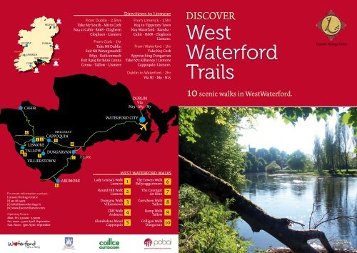
Lady Louisa’s Walk<br />
<strong>Lismore</strong><br />
Round Hill Walk<br />
<strong>Lismore</strong><br />
Dromana Walk<br />
Villierstown<br />
Cliff Walk<br />
Ardmore<br />
Glenshelane Wood<br />
Cappoquin 5<br />
Directions to <strong>Lismore</strong><br />
From Limerick - 1.5hr<br />
N24 to Tipperary Town<br />
N24 <strong>Waterford</strong> - Bansha -<br />
Cahir - R668 - Clogheen<br />
<strong>Lismore</strong>.<br />
From <strong>Waterford</strong> - 1hr<br />
Take N25 Cork<br />
Approaching Dungarvan<br />
Take N72 Killarney / <strong>Lismore</strong><br />
Cappoquin-<strong>Lismore</strong>.<br />
Dublin to <strong>Waterford</strong> - 2hr<br />
Via N7 - M9 - N25<br />
DUBLIN<br />
Via<br />
N25 - M9 - N7<br />
WEST WATERFORD WALKS<br />
1<br />
2<br />
3<br />
4<br />
The Towers Walk<br />
Ballysaggartmore<br />
The Cunnigar<br />
An Rinn<br />
Curraheen Walk<br />
Tallow<br />
Ramp Walk<br />
Tallow<br />
Colligan Walk<br />
Dungarvan<br />
6<br />
7<br />
8<br />
9<br />
10<br />
DISCOVER<br />
<strong>West</strong><br />
<strong>Waterford</strong><br />
<strong>Trails</strong><br />
10 scenic walks in <strong>West</strong><strong>Waterford</strong>.<br />
<strong>Lismore</strong> <strong>Heritage</strong> <strong>Centre</strong>
D I S C O V E R<br />
<strong>West</strong> <strong>Waterford</strong><br />
<strong>Trails</strong><br />
There is no better way to discover <strong>West</strong><br />
<strong>Waterford</strong>’s woodlands, coast, river<br />
banks and cliffs than on foot. <strong>West</strong><br />
<strong>Waterford</strong> <strong>Trails</strong> consists of 10 specially<br />
chosen walks. Beloved to locals, the<br />
walks are of moderate duration and<br />
generally suitable for all. Get out and<br />
about and see what you will discover.<br />
Lady Louisa’s Walk, <strong>Lismore</strong>.<br />
Round Hill Walk, <strong>Lismore</strong>.<br />
Dromana Walk, Villierstown.<br />
Cliff Walk, Ardmore.<br />
Glenshelane Walk, Cappoquin.<br />
The Towers Walk, Ballysaggartmore.<br />
The Cunnigar, Rinn.<br />
Curraheen Walk, Tallow.<br />
Ramp Walk, Tallow.<br />
Colligan Walk, Dungarvan.<br />
Lady Louisa’s Walk<br />
Directions:<br />
From the <strong>Heritage</strong> <strong>Centre</strong>, follow the<br />
N72, past the spout to the start of the<br />
bridge. Lady Louisa’s walk is located<br />
on the right just before the bridge.<br />
Parking is available.<br />
Points of Interest:<br />
• Lady Louisa was the daughter of the<br />
7th Duke of Devonshire, ancestor of<br />
the current owner of <strong>Lismore</strong> Castle,<br />
the 12th Duke of Devonshire.<br />
<strong>Lismore</strong><br />
Castle<br />
WC<br />
N72 CORK<br />
Cappoquin<br />
& <strong>Waterford</strong><br />
<strong>Lismore</strong> <strong>Heritage</strong> <strong>Centre</strong><br />
CALL TO OUR SHOP OR<br />
St. Carthage’s Cathedral<br />
L I S M O R E<br />
• The Spout is a natural spring well<br />
that provided water for the estate<br />
workers in the castle until the early<br />
part of the nineteenth century.<br />
• Lady Louisa’s walk is primarily a<br />
woodland walk along the river bank.<br />
One can expect to find woodland<br />
plants such as beech, ash, ferns,<br />
spindle tree, holly and ivy as well as<br />
wood sorrel, golden saxifrage and<br />
wild garlic but to name a few.<br />
School<br />
Start Finish<br />
R. Blackwater<br />
Distance:<br />
2km<br />
Duration:<br />
30 mins
Round Hill Walk<br />
Directions:<br />
From <strong>Lismore</strong>, follow the N72 to the<br />
start of the bridge. The Riverside walk<br />
is located on the right just before the<br />
bridge. Parking is available. Follow<br />
Lady Louisa’s walk until you reach the<br />
wrought iron gate. Instead of turning<br />
right up the hill, continue along the<br />
river bank.<br />
Points of Interest:<br />
•A typical riverside environment,<br />
home to herons, swans, mallards, water<br />
hens, snipe, tern, kingfisher and<br />
many more water birds.<br />
• The River Blackwater is renowned for<br />
its salmon fishing and fishing stands<br />
and stiles may be noted along the riverbank<br />
<strong>Lismore</strong><br />
Castle<br />
Cahir / Dublin<br />
St. Carthage’s<br />
Cathedral<br />
<strong>Lismore</strong> <strong>Heritage</strong> <strong>Centre</strong><br />
Cappoquin / <strong>Waterford</strong><br />
L I S M O R E<br />
• A stand of mature pine trees on top<br />
of a mound will indicate that you are<br />
approaching the famous Round Hill,<br />
a great mound or earthwork covering<br />
two or three acres in extent. The first<br />
monastic settlement in <strong>Lismore</strong> was<br />
founded by St. Carthage at Round Hill<br />
adjacent to the river, where he built a<br />
‘Lios’, an Irish term used to describe a<br />
fort built of earth. Legend has it that<br />
an old woman whom Carthage met,<br />
told him that he would be founder of a<br />
‘Lios Mor’ meaning great fort in Irish.<br />
• The monks built small beehive huts<br />
on the banks of the river and the place<br />
extended to become a great university<br />
city and a place of holiness.<br />
Start Finish<br />
Out Back ( Take care on Road )<br />
Short Walk<br />
Distance:<br />
5km<br />
Out and Back.<br />
Duration:<br />
1 Hour<br />
Dromana Walk V i l l i e r s t o w n<br />
Directions:<br />
From Cappoquin, follow the N72 and<br />
take the 1st right, sign posted to Villierstown.<br />
The first stage, known as<br />
‘Sailors Walk’ commences at Villierstown<br />
Quay following the banks of<br />
the River Blackwater. The 2nd stage,<br />
known as ‘Dromana Well Walk’ begins<br />
at the Dromana Forest car park following<br />
the forest trail.<br />
Points of Interest:<br />
• The R. Blackwater is tidal at Villierstown<br />
and as such is a habitat for many<br />
water birds including Heron, Egret,<br />
Cormorant, gulls and ducks. Other<br />
species such as Sandpiper, Grey Wagtail<br />
and Kingfisher can be occasionally<br />
seen and heard.<br />
To Cappoquin<br />
Wells View<br />
Point<br />
R. Blackwater<br />
• Dromana Wood forms part of the Villiers-Stuart<br />
Estate. The ‘Sailors Rock’ is<br />
a cliff face inside the wood that is said<br />
to hold the wishes of many a sailor who<br />
passed by it along the R. Blackwater.<br />
Deer, fox, red squirrel and badger are<br />
in evidence in Dromana wood as well<br />
as uncommon bird species such as the<br />
Peregrine Falcon, Hobby and Osprey.<br />
• A short distance away you will find<br />
the Hindu – Gothic Bridge built in the<br />
19th Century by Henry Villiers Stuart,<br />
inspired by the Brighton Pavilion. It<br />
was built as a temporary structure to<br />
welcome home a honeymoon couple<br />
who were so taken with it that they<br />
had it made permanent.<br />
Start & Finish<br />
Dromana Wells Walk<br />
Sailors Rock Walk<br />
Villierstown<br />
Sailors Rock View<br />
Distance:<br />
Dromana 2km<br />
Sailors 1.5k<br />
Duration:<br />
1.5 Hours
Cliff Walk<br />
Directions:<br />
From <strong>Lismore</strong>, take the N72 to Tallow.<br />
Drive straight through Tallow town<br />
and follow the R634 to Youghal. From<br />
Youghal, follow the N25 sign posted<br />
<strong>Waterford</strong>. Turn right onto the R673<br />
sign posted to Ardmore. Once in Ardmore<br />
park at the beach car park and<br />
take the middle road past the Cliff<br />
House Hotel. The walk begins just after<br />
the hotel car park – follow the road<br />
to where it becomes a path leading<br />
down to old ruins.<br />
Points of Interest:<br />
• St. Declan’s well & Church, Saint Declan<br />
founded a seminary in Ardmore<br />
circa 416. The holy well served as a Baptistery<br />
to early Christian Missionaries.<br />
To Cork<br />
Start<br />
To Dungarvan<br />
Finish<br />
Ardmore<br />
A R D M O R E<br />
• The coastguard station 1867 – taken<br />
over and burnt down by republicans on<br />
independence. The castle – built as the<br />
same time as the coast guard station,<br />
both abandoned in 1921. The spectacular<br />
wreck of the crane ship ‘Sampson’.<br />
• The cliff walk at Ardmore has an<br />
amazingly diverse range of flora, comprising<br />
of 113 species of wild flower,<br />
grasses and fern including orchids,<br />
vetchs, wild thyme and blue scabious.<br />
• The Ardmore Cliff Walk is also a birdwatchers<br />
paradise and is home to a<br />
host of Coastal birds. Other birds such<br />
as Rock Pipits, Pheasant, Kestrel, Peregrine<br />
Falcons occupy the habitat.<br />
Cliff House Hotel<br />
Distance:<br />
5km Cliff top<br />
Village loop.<br />
Duration:<br />
1 Hour<br />
Glenshelane Walk<br />
Directions:<br />
From Cappoquin travel the Clogheen<br />
/ Mellary Road R669 for a distance of<br />
1 km until you come to a grotto, veer<br />
right and the car park entrance is a<br />
short distance after crossing Bealick<br />
Bridge.<br />
Points of Interest:<br />
• Gleann Siothláin – the Glen of the<br />
Fairies, was owned by the Keane family<br />
of Cappoquin – Molly Keane, a well<br />
known novelist lived nearby in Bellville<br />
House.<br />
• Glenshelane is now a Coillte managed<br />
forest; tree Species to be seen<br />
on this site include Douglas fir, Sitka<br />
CAPPOQUIN<br />
Start<br />
Finish<br />
Loop Walks<br />
R. Monavugga<br />
C A P P O Q U I N<br />
spruce, Norway spruce, Japanese<br />
larch, Lodge pole pine, Silver fir, Scots<br />
pine, <strong>West</strong>ern Red cedar, Lawson cypress<br />
and broad leaves such as Spanish<br />
chestnut, beech, oak, ash, poplar,<br />
sycamore, birch and alder.<br />
• The battle between the Earls of Ormonde<br />
and the Earls of Desmond was<br />
fought at Affane in 1565 1km from the<br />
picnic site<br />
• The Glenshelane River is an important<br />
salmon nursery stream for the R.<br />
Blackwater; salmon can be seen fighting<br />
their way upstream to their spawning<br />
area north of the car park.<br />
Linear Walk<br />
Grotto<br />
Mount<br />
Melleray<br />
Monastery<br />
Distance:<br />
3 loops and<br />
1 linear walk.<br />
2.5km-10.7km
Enjoy the trails responsibly and respectfully:<br />
be safe, be mindful of Ireland’s changeable<br />
weather and follow the principles of ‘Leave<br />
No Trace’.<br />
• Plan Ahead and Prepare<br />
• Be Considerate of Others<br />
• Respect Farm Animals and Wildlife<br />
• Travel on Durable Ground<br />
• Leave What You Find<br />
• Dispose of Waste Properly<br />
• Minimise the Effects of Fire<br />
Why not make notes<br />
while on your Walk.<br />
Designed by Red Heaven Design - www.redheavendesign.com<br />
The Towers Walk<br />
Directions:<br />
Take the route R666 <strong>Lismore</strong>–Ballyduff<br />
-Fermoy Road sign-posted left<br />
over the bridge past <strong>Lismore</strong> Castle.<br />
Continue for approximately 3.5km to<br />
the Towers entrance on the right. Ample<br />
parking is provided.<br />
Points of interest:<br />
• Ballysaggartmore Towers are imposing<br />
gothic style gate lodges built<br />
in 1850 by Arthur Kiely Usher for his<br />
wife.<br />
• The gate lodge and towers provide a<br />
fairy tale setting which reflects the<br />
sad period in Irish history where extravagance<br />
and starvation lived side<br />
by side.<br />
• A diverse range of tree species to be<br />
noted including, ash, oak, sycamore,<br />
horse chestnut, spruce, fir as well as<br />
shrubs of holly, hazel and bramble.<br />
• The main avenue is planted with a<br />
row of tall shaking poplars and rhododendron,<br />
interspersed by pheasant<br />
berry, snow berry, holly to name but a<br />
few.<br />
• Wooden benches are provided along<br />
the walk, where you can take few moments<br />
to relax while listening to the<br />
sounds of nature around you.<br />
B A L LY S A G G A R T M O R E<br />
Folly<br />
Ballyduff<br />
Towers<br />
Walk<br />
Start Finish<br />
<strong>Lismore</strong><br />
Gate Lodge<br />
<strong>Lismore</strong><br />
Distance:<br />
2km looped<br />
forest walk.<br />
Duration:<br />
30 Min.
Cunnigar Walk<br />
Directions:<br />
Leave Dungarvan heading west on the<br />
N25 towards Cork. Turn left on the<br />
R674 signposted for An Rinn (Ring).<br />
Follow the signs to ‘An Coinigéar’ to<br />
the right.<br />
Points of Interest:<br />
• The Cunnigar is a long sandy spit that<br />
has formed across the mouth of Dungarvan<br />
Bay.<br />
• The Cunnigar is one of the best winter<br />
bird watching locations in Dungarvan<br />
Dungravan<br />
N25<br />
R. Brickey<br />
Start Finish<br />
A N R I N N<br />
Bay in terms of diversity and numbers.<br />
It is the top site in <strong>Waterford</strong> for rare<br />
waders such as Little Ringed Plover &<br />
American Golden Plover.<br />
• The sheltered bay and the presence of<br />
eel grass in the shallow waters on the<br />
landward side are conducive to large<br />
numbers of grazing wildfowl such as<br />
Brent Geese and Wigeon<br />
• The marshy west side of the bank is<br />
good for teal, snipe, herons and cormorants.<br />
An Rinn<br />
Distance:<br />
6km Out & Back<br />
Beach & Dunes<br />
Duration:<br />
1.5 Hours<br />
Curraheen Walk<br />
TA L L O W<br />
Directions:<br />
From <strong>Lismore</strong>, follow the N72 to Tallow.<br />
The Bride View bar is located on<br />
the left of Tallow Bridge. Parking is<br />
available. The walk commences at the<br />
Bride View bar – follow the minor road<br />
parallel to the N72, this will lead you<br />
up the hill towards the entrance to Mc-<br />
Donalds Fruit Farm on the right.<br />
Points of Interest:<br />
• This walk offers fantastic views of the<br />
Bride valley and the landscape to the<br />
south, taking in the rolling hills and<br />
forests in the distance.<br />
To <strong>Lismore</strong><br />
Tallow<br />
Bride View<br />
Bar & Restaurant<br />
R. Bride<br />
Start & Finish at The Bride View Bar & Restaurant<br />
• The walk offers a mixture of the cultivated<br />
and the wild with apple trees<br />
gracing the hillside and the river environment<br />
below.<br />
• The barely-visible remnants of the<br />
quay in Tallow serve as a reminder of<br />
the once thriving business carried out<br />
in days of yore on this stretch of the<br />
River Bride.<br />
Distance:<br />
5km road loop<br />
Duration:<br />
1 Hour
Ramp WalkTA<br />
L L O W<br />
Directions:<br />
From <strong>Lismore</strong>, take the N72 to Tallow.<br />
The ramp walk commences at Tallow<br />
creamery on the right. The first segment<br />
of the walk brings one along the<br />
River Bride, taking in Lisfinney Castle<br />
to the North. The circuit then brings<br />
the walker back to <strong>West</strong> Street and<br />
down the Main Street of the town back<br />
to the old creamery entrance.<br />
Points of Interest:<br />
• The River Bride is famous for its excellent<br />
stocks of brown trout and coarse<br />
fish of Bream, Perch, Eel and Roach.<br />
• Lisfinney Castle, now in ruins was<br />
built in the sixteenth century by the<br />
Earls of Desmond (also of Dromana)<br />
Start<br />
Finish<br />
and acquired by Walter Raleigh as<br />
was the town, for his part in crushing<br />
the second Desmond Rebellion.<br />
Lisfinney was sold by Raleigh to Sir<br />
Richard Boyle of <strong>Lismore</strong> Castle who<br />
commenced Iron Smelting in Tallow -<br />
hence the Irish name Tulach an Iarainn<br />
(Hill of Iron). This industry continued<br />
until all the surrounding forests were<br />
consumed for charcoal.<br />
• Tallow is probably best known for its<br />
horse fair, one of the oldest in Ireland.<br />
Held at the beginning of September<br />
every year, the horse fair attracts national<br />
and international buyers and<br />
sellers as well as throngs of visitors.<br />
TALLOW<br />
To <strong>Lismore</strong><br />
Distance:<br />
3km loop<br />
Duration:<br />
40 Mins.<br />
Colligan Walk<br />
Directions:<br />
Colligan is located 8km north of<br />
Dungarvan on the Clonmel Road.<br />
From <strong>Lismore</strong>, take the N72 toward<br />
Dungarvan. Take the left exit at the<br />
fork in the road at the Master McGrath<br />
monument. Travel a further 4km to the<br />
next junction and exit right to Kilbrien<br />
road. Travel 2km on this road to the<br />
wood entrance.<br />
Points of Interest:<br />
• The town land of Colligan - An Cuilligeáin<br />
- means hazel abounding place<br />
Colligan wood lies in a beautiful scenic<br />
valley through which the River Colligan<br />
flows and enters the sea at Dungarvan<br />
Bay. There are steep wooded<br />
glens on each side of the river. The<br />
area still carries some remnants of the<br />
old woodland oaks.<br />
• There are a variety of forest walks<br />
along the riverside and through the<br />
mixed woodland of conifers and broad<br />
leaves; easy short walks can be enjoyed<br />
on either side of the picnic area whereas<br />
longer and more strenuous walks<br />
can be had by taking in the loop walk<br />
from the picnic site.<br />
• Many trees around the picnic site and<br />
along the walks have been labelled for<br />
easy identification. The fertile soil<br />
here is derived from old red sandstone.<br />
The Colligan River is a salmon spawn-<br />
D U N G A R VA N<br />
ing river with sea trout also to be seen.<br />
Norway spruce, <strong>West</strong>ern hemlock,<br />
Japanese larch, Sitka spruce, oak, ash,<br />
beech, maple and birch are the main<br />
tree species here.<br />
• Because of the many clearings and<br />
deciduous trees, an excellent selection<br />
of woodland flora is present such<br />
as wood sorrel, wood rush, heather,<br />
blueberry and bilberry.<br />
GREENANNE<br />
WALK<br />
Start Finish<br />
Distance:<br />
5km looped<br />
forest walk<br />
Duration:<br />
1.5 Hours