Weedon Island Canoe Trail Map: North - Pinellas.WaterAtlas.org
Weedon Island Canoe Trail Map: North - Pinellas.WaterAtlas.org
Weedon Island Canoe Trail Map: North - Pinellas.WaterAtlas.org

Create successful ePaper yourself
Turn your PDF publications into a flip-book with our unique Google optimized e-Paper software.
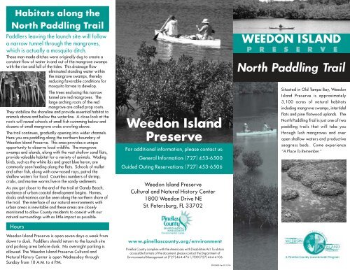
Habitats along the<br />
<strong>North</strong> Paddling <strong>Trail</strong><br />
Paddlers leaving the launch site will follow<br />
a narrow tunnel through the mangroves,<br />
which is actually a mosquito ditch.<br />
These man-made ditches were originally dug to create a<br />
constant flow of water in and out of the mangrove swamps<br />
with the rise and fall of the tides. This drainage flow<br />
eliminated standing water within<br />
the mangrove swamps, thereby<br />
reducing favorable conditions for<br />
mosquito larvae to develop.<br />
The trees enclosing this narrow<br />
tunnel are red mangroves. The<br />
large arching roots of the red<br />
mangrove are called prop roots.<br />
They stabilize the shoreline and provide essential habitat to<br />
animals above and below the waterline. A close look at the<br />
roots will reveal schools of small fish swimming below and<br />
dozens of small mangrove crabs crawling above.<br />
The trail continues, gradually opening into wider channels.<br />
Here you are paddling along the northern boundary of<br />
<strong>Weedon</strong> <strong>Island</strong> Preserve. This area provides a unique<br />
opportunity to observe local wildlife. The mangrove<br />
swamps and islands, along with the vast shallow sand flats,<br />
provide valuable habitat for a variety of animals. Wading<br />
birds, such as the white ibis and great blue heron, are<br />
commonly seen feeding along the flats. Schools of mullet<br />
and other fish, along with cow-nosed rays, patrol the<br />
shallow waters for food. Countless numbers of shrimp,<br />
crabs, and marine worms live in the sandy sediments.<br />
As you get closer to the end of the trail at Gandy Beach,<br />
evidence of urban coastal development begins. Homes,<br />
docks and marinas can be seen along the northern shore of<br />
the trail. The interface of our natural environments with<br />
urban areas is inevitable and these areas are closely<br />
monitored to allow County residents to coexist with our<br />
natural surroundings with as little impact as possible.<br />
Hours<br />
<strong>Weedon</strong> <strong>Island</strong> Preserve is open seven days a week from<br />
dawn to dusk. Paddlers should return to the launch site<br />
and parking area before dusk. No overnight parking is<br />
allowed. The <strong>Weedon</strong> <strong>Island</strong> Preserve Cultural and<br />
Natural History Center is open Wednesday through<br />
Sunday from 10 A.M. to 4 P.M.<br />
<strong>Weedon</strong> <strong>Island</strong><br />
Preserve<br />
For additional information, please contact us:<br />
General Information: (727) 453-6500<br />
Guided Outing Reservations: (727) 453-6506<br />
<strong>Weedon</strong> <strong>Island</strong> Preserve<br />
Cultural and Natural History Center<br />
1800 <strong>Weedon</strong> Drive NE<br />
St. Petersburg, FL 33702<br />
www.pinellascounty.<strong>org</strong>/environment<br />
<strong>Pinellas</strong> County complies with the Americans with Disabilities Act. To obtain<br />
accessible formats of the document, please contact the Department of<br />
Environmental Management at: (727) 464-4761/TDD (727) 464-4106<br />
ENVLNDS Ver 03.12.04<br />
WEEDON ISLAND<br />
P R E S E R V E<br />
<strong>North</strong> Paddling <strong>Trail</strong><br />
Situated in Old Tampa Bay, <strong>Weedon</strong><br />
<strong>Island</strong> Preserve is approximately<br />
3,100 acres of natural habitats<br />
including mangrove swamps, intertidal<br />
flats and pine flatwood uplands. The<br />
<strong>North</strong> Paddling <strong>Trail</strong> is just one of two<br />
paddling trails that will take you<br />
through lush mangroves and over<br />
open shallow waters and productive<br />
seagrass beds. Come experience<br />
“A Place To Remember.”
<strong>North</strong> Paddling <strong>Trail</strong><br />
• The parking area and launch site for the <strong>North</strong><br />
Paddling <strong>Trail</strong> are located on the east side of San<br />
Martin Boulevard approximately 1 / 2 mile north of the<br />
Preserve's entrance.<br />
• The <strong>North</strong> Paddling <strong>Trail</strong> is approximately 2 miles<br />
long and takes about 1 1 / 2 hours to complete.<br />
• Numbered markers are strategically located along<br />
the trail to help paddlers orient themselves.<br />
• Please check a tide chart before venturing out. This<br />
trail is shallow and it is best paddled with a mid to<br />
high tide.<br />
Area<br />
Enlarged<br />
<strong>Weedon</strong><br />
<strong>Island</strong><br />
1<br />
Legend<br />
Roads<br />
<strong>North</strong> Paddling <strong>Trail</strong><br />
Launch<br />
Paddling <strong>Trail</strong> Markers<br />
Parking Area<br />
Gandy Blvd.<br />
7<br />
8<br />
Tampa<br />
Bay<br />
• Fishing is allowed - State and Federal fishing<br />
regulations apply.<br />
• Please properly dispose of or take your trash with you.<br />
Paddling Safety Tips…<br />
• Always use an approved Personal Flotation Device<br />
(PFD).<br />
• Bring plenty of water, even on cool days.<br />
• Protect yourself from the sun using sunscreen and a<br />
hat, even on overcast days.<br />
• Insects go with the territory! Insect repellent and<br />
lightweight long sleeved shirts help reduce their<br />
biting opportunities.<br />
• Consult your compass often.<br />
P<br />
San Martin Blvd.<br />
1<br />
2<br />
3<br />
Snug<br />
Harbor<br />
4<br />
5<br />
6<br />
Masters<br />
Bayou<br />
<strong>Weedon</strong><br />
<strong>Island</strong><br />
About the Preserve…<br />
<strong>Weedon</strong> <strong>Island</strong> Preserve is managed by <strong>Pinellas</strong> County<br />
Department of Environmental Management's Environmental<br />
Lands Division. The Preserve, and its various public<br />
recreation opportunities, is possible through the continued<br />
support of the <strong>Pinellas</strong> County Board of County<br />
Commissioners and the citizens of <strong>Pinellas</strong> County.<br />
Preserve<br />
Entrance<br />
P<br />
Other public use opportunities…<br />
While you are here, please visit the <strong>Weedon</strong> <strong>Island</strong><br />
Preserve Cultural and Natural History Center, an education<br />
facility located in the heart of the Preserve. Also, enjoy our<br />
fishing pier, elevated boardwalk with an observation tower<br />
and various hiking trails. Public restrooms are located at<br />
both the Center and the fishing pier.<br />
Riviera<br />
Bay<br />
Feet<br />
500 250 0 500 1,000<br />
To <strong>Weedon</strong> <strong>Island</strong><br />
Preserve Cultural and<br />
Natural History Center