Utilities - City of Hilliard
Utilities - City of Hilliard
Utilities - City of Hilliard

You also want an ePaper? Increase the reach of your titles
YUMPU automatically turns print PDFs into web optimized ePapers that Google loves.
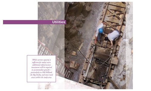
While current capacity is<br />
sufficient for today’s users,<br />
additional infrastructure<br />
investment will be required<br />
to accommodate growth—<br />
particularly in Old <strong>Hilliard</strong>,<br />
the Big Darby, and most rural<br />
areas within the study area.<br />
<strong>Utilities</strong>
Chapter 9:<br />
<strong>Utilities</strong><br />
<strong>Utilities</strong> Goal<br />
Continue to provide high quality public utility service to both current and future users,<br />
balancing the objectives <strong>of</strong> increasing system capacity and improving system reliability<br />
with the need <strong>of</strong> ensuring reasonable utility rates for all users.<br />
Both public and private utilities provide a broad<br />
range <strong>of</strong> services to those who live and work<br />
within the <strong>City</strong> <strong>of</strong> <strong>Hilliard</strong>. <strong>City</strong> owned and<br />
operated utilities include drinking water, sanitary<br />
sewer, and stormwater systems. Private utilities<br />
include natural gas provided by Columbia Gas <strong>of</strong><br />
Ohio, electricity provided by AEP Ohio, and solid<br />
waste collection and recycling services both provided<br />
by Rumpke. Traditional land-line telephone<br />
service is provided by AT&T, and fiber- and cablebased<br />
telephone, broadband internet, and cable<br />
television services are provided by AT&T, Time<br />
Warner Cable, and WOW Internet and Cable.<br />
Together, <strong>Hilliard</strong> and these private companies<br />
work to meet the needs <strong>of</strong> those who live and do<br />
business in the <strong>City</strong>.<br />
Generally, the private utilities own, operate,<br />
and maintain their infrastructure. Though their<br />
services are essential, they are not analyzed in this<br />
plan given that they are not owned, managed, or<br />
maintained by the <strong>City</strong>. It is assumed that these<br />
firms will make the investments necessary to maintain<br />
and expand their systems as the <strong>City</strong> grows.<br />
This plan, and specifically this chapter, addresses<br />
the three <strong>City</strong>-owned public utilities.<br />
Opposite: Nearly 50 feet below the surface, workers assemble<br />
tracks that will guide a tunnel boring machine as it drills<br />
a new sanitary sewer trunk line under I-270 near Hayden<br />
Run Road. Given <strong>Hilliard</strong>’s relatively flat terrain, extending<br />
gravity-fed sewer service has been a difficult and expensive<br />
task necessary to support future development.<br />
<strong>Utilities</strong><br />
177
<strong>Utilities</strong><br />
Key Findings<br />
1 in = 1.515151515 miles<br />
1 inch = 8,000 feet<br />
Water and Sanitary Sewer service<br />
In 1994, <strong>Hilliard</strong> entered into two 49-year contracts<br />
with the <strong>City</strong> <strong>of</strong> Columbus to provide fresh<br />
drinking water and dispose <strong>of</strong> sanitary sewer waste<br />
from the city. These agreements require <strong>Hilliard</strong> to<br />
own, operate, and maintain the water distribution<br />
and sanitary sewer collection systems within its<br />
<strong>City</strong> limits and a designated service area (see Map<br />
9.1), connecting Columbus’ drinking water and<br />
sanitary sewer disposal services to local homes and<br />
businesses. To help <strong>Hilliard</strong> maintain and expand<br />
its network, a small portion <strong>of</strong> each user’s monthly<br />
water and sewer bill is directed to the <strong>City</strong> to<br />
maintain and manage the systems within <strong>Hilliard</strong>.<br />
With a dedicated service area, only <strong>Hilliard</strong> is<br />
permitted to provide water and sanitary sewer<br />
service to this area. This virtually prohibits any<br />
neighboring municipalities from annexing into the<br />
service area as they would not be able to supply<br />
water and sewer services needed for development.<br />
Those seeking water and sewer service must petition<br />
<strong>Hilliard</strong> to be incorporated, and then pay to<br />
tap into its water and sanitary sewer networks.<br />
As <strong>Hilliard</strong> has grown over the years, more and<br />
more developers, home owners, and businesses<br />
have gone through this process, expanding both<br />
the <strong>City</strong> and the needs placed on the water and<br />
sanitary sewer systems.<br />
Water and Sanitary Sewer Master Plans<br />
Over the past 10 years, the <strong>City</strong> has undertaken<br />
several studies and in 2001 created master planning<br />
documents to guide the development <strong>of</strong> its<br />
water and sanitary sewer systems. These studies<br />
and planning documents have helped the <strong>City</strong><br />
Map 9.1 – <strong>Hilliard</strong>’s Utility Service Area<br />
Legend<br />
<strong>Hilliard</strong> Corp Limit<br />
Utility Service Area, and<br />
Study Area boundary<br />
0 2,000 4,000 8,000<br />
1 inch = 8000 feet<br />
Scioto & Darby Creek Rd<br />
±<br />
Walker Rd<br />
Hayden Run Rd<br />
Elliott Rd<br />
Davis Rd<br />
Alton & Darby Creek Rd<br />
Cosgray Rd<br />
better understand its systems and how to manage<br />
and maintain its infrastructure.<br />
As a part <strong>of</strong> this comprehensive planning effort,<br />
<strong>Hilliard</strong>’s 2001 Water Master Plan and 2001<br />
Sanitary Sewer Master Plan are being updated.<br />
The development <strong>of</strong> <strong>Hilliard</strong>’s new 2011 Water<br />
RINGS<br />
Hayden Run Blvd<br />
Leppert Rd<br />
Main St<br />
Avery Rd<br />
Davidson Rd<br />
Scioto Darby Rd<br />
Frazell Rd<br />
<strong>Hilliard</strong> Rome Rd<br />
Wilcox Rd<br />
Britton Pkwy<br />
Cemetery Rd<br />
Walcutt Rd<br />
Leap Rd<br />
Lacon Rd<br />
§¨¦ 270<br />
Roberts Rd<br />
True ma n Blvd<br />
§¨¦ 270<br />
Dublin Rd<br />
Dublin Rd<br />
Scioto River<br />
<strong>Hilliard</strong> Comprehensive Plan<br />
178
Master Plan will be greatly impacted by the results<br />
<strong>of</strong> an on-going <strong>City</strong> <strong>of</strong> Columbus study analyzing<br />
the water distribution system in northwestern<br />
Franklin County, including the distribution <strong>of</strong><br />
water through and around the <strong>City</strong> <strong>of</strong> <strong>Hilliard</strong>.<br />
Expected to be released in 2011, the Columbus<br />
study will influence the recommendations within<br />
<strong>Hilliard</strong>’s 2011 Water Master Plan.<br />
Once the Water Plan is completed, this will be<br />
used to guide the recommendations <strong>of</strong> <strong>Hilliard</strong>’s<br />
2011 Sanitary Sewer Master Plan. Still under<br />
development at the time <strong>of</strong> the Comprehensive<br />
Plan’s adoption, the 2011 Water and Sanitary<br />
Sewer master plans will be the key documents for<br />
guiding <strong>City</strong> utility management, maintenance,<br />
and expansion activities into the future. Though<br />
the Comprehensive Plan seeks to provide a planning<br />
level overview <strong>of</strong> the needs <strong>of</strong> the utility<br />
system, deference should be provided to the 2011<br />
master plans for a detailed analysis and a comprehensive<br />
list <strong>of</strong> capital improvement and maintenance<br />
recommendations.<br />
Drinking Water Supply<br />
The source <strong>of</strong> <strong>Hilliard</strong>’s drinking water is largely<br />
from the Scioto River, specifically Columbus’<br />
O’Shaughnessy and Griggs reservoirs. These<br />
facilities feed Columbus’ Dublin Road Water<br />
Treatment Plant, which is currently being<br />
expanded to meet future demand in central,<br />
southwestern, and northwestern Franklin County.<br />
The water service agreement between <strong>Hilliard</strong> and<br />
Columbus ensures the city’s users will have a supply<br />
<strong>of</strong> fresh and clean drinking water (Figure 9.1).<br />
In addition to serving users in <strong>Hilliard</strong>, Columbus<br />
provides service to the <strong>City</strong> <strong>of</strong> Dublin as well as<br />
Columbus’ own residential and business users in<br />
northwestern Franklin County. To ensure a high<br />
quality <strong>of</strong> service for all users, Columbus maintains<br />
a water delivery system that is interconnected<br />
across municipal boundaries. Upon being piped<br />
into the <strong>Hilliard</strong> area, water may flow directly to<br />
individual users or be stored in one <strong>of</strong> several storage<br />
tank facilities (or water towers) located within<br />
and outside <strong>of</strong> <strong>Hilliard</strong>’s service area. By design,<br />
the interconnected system <strong>of</strong> storage tank facilities<br />
and water mains owned and located within either<br />
Columbus or <strong>Hilliard</strong> work together to serve users<br />
in both jurisdictions. Storage tanks help maintain<br />
water pressure and provide a reserve in case <strong>of</strong> a<br />
fire emergency. Because the water lines are pressurized,<br />
drinking water is able to flow both up and<br />
down hill and is relatively easy to direct around<br />
the <strong>City</strong> as there is need.<br />
Capacity for Growth<br />
<strong>Hilliard</strong>’s water distribution system is sufficient<br />
for current users, maintaining sufficient pressure<br />
around the <strong>City</strong>. As large developments are built<br />
placing significant demands on the system, new<br />
water mains, system connections, and storage<br />
tanks will be necessary. Access is available in all<br />
focus areas except for the Big Darby Focus Area.<br />
Beyond the Focus Areas, the water distribution<br />
system may likely require the extension or creation<br />
<strong>of</strong> new water mains to ensure adequate pressure<br />
and volume to new development. While the 2011<br />
Water Master Plan will provide specific recommendations<br />
for expanding the overall system,<br />
developers will largely be responsible for ensuring<br />
proper access to local users in their developments.<br />
Figure 9.1 – <strong>Hilliard</strong>’s drinking water is collected from the Scioto River Watershed.<br />
Water from the Scioto River is stored in O’Shaughnessy and Griggs reservoirs, is treated at<br />
the Dublin Road Water Treatment Plant, and then piped to the <strong>City</strong> <strong>of</strong> <strong>Hilliard</strong>.<br />
<strong>Utilities</strong><br />
179
Map 9.2 – <strong>Hilliard</strong> Sanitary Sewer Network<br />
RINGS<br />
Legend<br />
Public Sanitary Lift Station<br />
Private Sanitary Lift Station<br />
Hayden Run Blvd<br />
Wilcox Rd<br />
Columbus Sanitary Sewers<br />
Sanitary Sewer Mains (10"-15")<br />
Sanitary Sewer Sub-Trunk (18"-36")<br />
Sanitary Sewer Trunk Mains (42"-60")<br />
Sanitary Sewer Trunk Mains (72"-84")<br />
Hayden Run Rd<br />
Cosgray Rd<br />
Britton Pkwy<br />
§¨¦ 270<br />
Dublin Rd<br />
Avery Rd<br />
Leppert Rd<br />
<strong>Hilliard</strong> Sanitary Sewers<br />
Sanitary Sewer Mains (10"-15")<br />
Sanitary Sewer Sub-Trunk (18"-36")<br />
Davidson Rd<br />
Leap Rd<br />
Sanitary Sewer Force Mains<br />
Elliott Rd<br />
<strong>Hilliard</strong> Sewersheds<br />
Davdison Road Trunk<br />
Hayden Run Trunk<br />
<strong>Hilliard</strong> Outfall Trunk<br />
Roberts-Milikin Trunk<br />
Sicoto Run/<strong>Hilliard</strong> NE Trunk<br />
Smiley Road Subtrunk<br />
Tuttle Trunk<br />
Scioto & Darby Creek Rd<br />
Davis Rd<br />
Main St<br />
Cemetery Rd<br />
Lacon Rd<br />
Tru ema n B<br />
lvd<br />
Scioto River<br />
Alton & Darby Creek Rd<br />
Scioto Darby Rd<br />
<strong>Hilliard</strong> Corp Limit<br />
Utility Service Area, and Study Area<br />
Frazell Rd<br />
Walker Rd<br />
Walcutt Rd<br />
Roberts Rd<br />
§¨¦ 270<br />
Dublin Rd<br />
<strong>Hilliard</strong> Rome Rd<br />
0 0.5<br />
1 2<br />
1 inch = 1 mile<br />
±<br />
<strong>Hilliard</strong> Comprehensive Plan<br />
Sanitary Sewer<br />
Sanitary sewer service is provided by <strong>Hilliard</strong>, who<br />
owns and operates the citywide network <strong>of</strong> sewer<br />
mains and trunk sewers which remove waste from<br />
buildings throughout <strong>Hilliard</strong> and direct it into<br />
one <strong>of</strong> six major trunk sewers. From here, waste<br />
flows into one <strong>of</strong> Columbus’ networks, specifically<br />
one <strong>of</strong> two regional trunk sewers, one near<br />
Roberts Road and another along Dublin Road.<br />
These regional sewers eventually direct the waste<br />
to Columbus’ Jackson Pike Wastewater Treatment<br />
Plant.<br />
Unlike the drinking water system, sanitary sewer<br />
mains are typically not pressurized and operate<br />
by allowing gravity to carry wastewater downhill.<br />
By design, sanitary sewer service typically follows<br />
natural watershed boundaries, allowing gravity to<br />
180
carry the waste to a single point where it enters a<br />
larger sewer main. Generally conforming to the<br />
topography and watersheds <strong>of</strong> the city, there are<br />
six major sanitary sewersheds. Map 9.2 on page<br />
180 shows the locations <strong>of</strong> key infrastructure, specifically<br />
sanitary sewer mains and lift stations.<br />
Lift Stations<br />
In places where land topography does not allow<br />
wastewater to run downhill, lift stations or large<br />
pumps are used to force the wastewater horizontally<br />
or even uphill through a pressurized “force<br />
main” to a point where the wastewater can then<br />
again be carried away by gravity. Though lift<br />
stations and force mains are less expensive to<br />
construct than gravity mains, lift stations have<br />
on-going maintenance and operation expenses.<br />
Additionally, a pump failure or power outage<br />
could cause the station to fail, possibly resulting in<br />
wastewater backing up into basements. <strong>Hilliard</strong>’s<br />
generally flat terrain and location, straddling both<br />
the Big Darby Creek and Scioto River watersheds,<br />
has required the use <strong>of</strong> lift stations to move wastewater<br />
from the Big Darby watershed to the Scioto<br />
River watershed.<br />
At the adoption <strong>of</strong> this plan, there were 13 public<br />
sanitary sewer lift stations operating in the city.<br />
Annual costs, calculated in 2008 for <strong>Hilliard</strong>’s Lift<br />
Station Master Plan, included about $17,000 in<br />
electric costs (for eight major sanitary pump stations)<br />
and about $190,000 in annual maintenance<br />
costs. The same plan recommended over $2 million<br />
in capital improvements and studies between<br />
2008 and 2013. Study results may produce<br />
additional recommendations for further investments<br />
in the lift station system. Though these lift<br />
stations have allowed development to occur where<br />
it was cost-prohibitive to build a gravity sewer, the<br />
result is a future stream <strong>of</strong> cost to operate, maintain,<br />
upgrade and eventually replace the facilities.<br />
In most cases, these costs have been passed onto all<br />
users <strong>of</strong> the system, subsidizing their use and the<br />
development they support.<br />
Inflow and Infiltration<br />
Most all sanitary sewer networks experience a phenomenon<br />
called Inflow and Infiltration or “I/I”<br />
(see Figure 9.2). As most sanitary sewer mains are<br />
not under pressure and, as such, require gravity<br />
to drain correctly, ground water can “Infiltrate”<br />
around old pipe fittings and enter the sanitary<br />
sewer system. Additionally, there may be locations<br />
where stormwater is able to enter or “Inflow” into<br />
the network through the improper connection<br />
<strong>of</strong> sump pumps, down spouts, and under drains<br />
to the sanitary sewer pipes. Regardless <strong>of</strong> the<br />
source, Inflow and Infiltration results in the loss<br />
<strong>of</strong> valuable and needed sanitary sewer capacity<br />
to stormwater that does not need to be treated as<br />
wastewater. Typical <strong>of</strong> older sanitary sewer systems,<br />
I/I issues may result in situations where the capacity<br />
designed for current and future users is temporarily<br />
exceeded by groundwater and/or stormwater,<br />
possibly resulting in a sanitary sewer overflow<br />
(SSOs) onto a street, into a creek, or producing<br />
water in basement (WIB) incidents. Though none<br />
<strong>of</strong> these events are common, they most likely<br />
occur when groundwater levels are at their highest,<br />
usually between the end <strong>of</strong> winter (snow melts)<br />
and early spring (major rain events).<br />
<strong>Hilliard</strong> Outfall Sewer<br />
<strong>Hilliard</strong> observed some <strong>of</strong> the issues mentioned<br />
above in the <strong>Hilliard</strong> Outfall Sewer. The <strong>City</strong> had<br />
a study conducted in 2009 to model the conditions<br />
creating the overflow events. Though the<br />
sewer works fine in normal weather, I/I issues<br />
result in significant influxes <strong>of</strong> stormwater into<br />
the network. The presence <strong>of</strong> these events in some<br />
sanitary sewer sheds may limit the potential to add<br />
significant amounts <strong>of</strong> new development in this<br />
Figure 9.2 – Potential Sources<br />
<strong>of</strong> I/I. While newer homes and<br />
modern sanitary sewer systems have<br />
been constructed to more stringent<br />
standards, older homes and neighborhoods<br />
may have deteriorated<br />
systems or these systems may have<br />
even been designed to encourage<br />
I/I flows to help those systems<br />
function.<br />
<strong>Utilities</strong><br />
181
Map 9.3 – <strong>Hilliard</strong> Sanitary Sewer System Access and Capacity<br />
Legend<br />
<strong>Hilliard</strong> Corp Limit<br />
Study Area Boundary<br />
Sufficient Capacity<br />
Hayden Run Rd<br />
RINGS<br />
Hayden Run Blvd<br />
Wilcox Rd<br />
Riggins Rd<br />
§¨¦ 270<br />
Capacity for Growth<br />
Beyond the issues addressed in this chapter,<br />
<strong>Hilliard</strong>’s existing sanitary sewer system (see Map<br />
9.2, page 180) is in otherwise acceptable shape<br />
and able to support additional users. A planninglevel<br />
capacity analysis <strong>of</strong> the Focus Areas shows:<br />
Edwards Farms Rd<br />
Dexter Falls Rd<br />
Dublin Rd<br />
Britton Pkwy<br />
Sufficient Capacity*<br />
Requires gravity sewer<br />
access, capacity<br />
Requires additional<br />
gravity sewer capacity<br />
Lift Station/Gravity<br />
Sewer servicable area<br />
Lift Station dependent<br />
areas<br />
Scioto & Darby Creek Rd<br />
Walker Rd<br />
Elliott Rd<br />
Davis Rd<br />
Cosgray Rd<br />
Leppert Rd<br />
Avery Rd<br />
Main St<br />
Frazell Rd<br />
Northwest Pkwy<br />
Scioto Darby Rd<br />
Davidson Rd<br />
Cemetery Rd<br />
Spri ngdale Blvd<br />
Leap Rd<br />
Anso n Dr<br />
True ma n Blvd<br />
Scioto River<br />
• I-270 Corridor: Where land use and density<br />
changes are recommended, capacity is largely<br />
sufficient for the vast majority <strong>of</strong> future growth<br />
planned for in the Land Use and Focus Area<br />
chapters. The remaining capacity needed<br />
for the northwest quadrant <strong>of</strong> the Cemetery<br />
Road/I-270 interchange could be supplied<br />
by taking users out <strong>of</strong> the Scioto Run Trunk<br />
Sewer and connecting them to the Hayden Run<br />
or Davidson Road sewersheds as these trunk<br />
sewers may be extended. Depending upon the<br />
build-out <strong>of</strong> the I-270 Corridor Focus Area, a<br />
capacity enhancement may be required in the<br />
future.<br />
Alton & Darby Creek Rd<br />
Walcutt Rd<br />
Lacon R d<br />
0 0.5 1 2<br />
1 inch = 1 mile<br />
±<br />
Roberts Rd<br />
*Though capacity is not a problem in the short run, the number <strong>of</strong> users that may eventually be added to this sewershed could exceed its capacity at some point<br />
in the future. As the I-270 Focus Area develops, TIF funds could be used to address this concern. Solutions may include increasing the capacity <strong>of</strong> the existing<br />
trunk sewer main and/or shifting users in the north and west ends <strong>of</strong> the sewershed to a different sewershed.<br />
Spindler Rd<br />
<strong>Hilliard</strong> Rome Rd<br />
§¨¦ 270<br />
Dublin Rd<br />
• Darby Area: Sanitary sewer service has yet to<br />
be extended to the vast majority <strong>of</strong> the Darby<br />
Focus Area. Though access has been constructed<br />
to support development in several places, all<br />
access to the sanitary sewer system has been<br />
dependent upon at least one lift station to<br />
pump wastewater out <strong>of</strong> the area. Lift station<br />
capacities are limited but in some cases can be<br />
increased to accommodate new development<br />
adjacent to existing development.<br />
sanitary sewershed, particularly the Old <strong>Hilliard</strong><br />
Focus Area, until a solution is implemented. The<br />
2009 study recommends several improvement<br />
projects to reduce the risk <strong>of</strong> future overflows and<br />
eventually provide more capacity. These recommendations<br />
vary in effectiveness and their costs<br />
range from $346,000 to $3.6 million.<br />
• Retired Railroad Corridor: Though sanitary<br />
sewer service is in close proximity to the retired<br />
railroad corridor, it is provided by the <strong>Hilliard</strong><br />
Outfall Sewer. Improvements that provide<br />
better access and additional capacity will be<br />
<strong>Hilliard</strong> Comprehensive Plan<br />
182
equired to support the density <strong>of</strong> development<br />
recommended for this Focus Area.<br />
• Old <strong>Hilliard</strong>: As Old <strong>Hilliard</strong> lies within the<br />
sewershed <strong>of</strong> the <strong>Hilliard</strong> Outfall Sewer, the<br />
ability for growth to be accommodated within<br />
Old <strong>Hilliard</strong> may depend largely upon the<br />
implementation <strong>of</strong> solutions to reduce I/I and<br />
improve capacity to the area. The construction<br />
<strong>of</strong> a gravity-fed relief sewer from Old <strong>Hilliard</strong><br />
to I-270 has the potential to solve these capacity<br />
problems. Such a relief sewer may be able to be<br />
located within a portion <strong>of</strong> the Retired Railroad<br />
Corridor, providing the access and capacity to<br />
the Focus Area, whose growth may be able to<br />
help finance the relief sewer.<br />
Beyond the Focus Areas, gravity-fed sanitary sewer<br />
service is readily available to developable properties<br />
along the Britton Parkway, Trueman Boulevard,<br />
Davidson Road, and Riggins Road corridors in<br />
the northeastern to east-central areas <strong>of</strong> the city.<br />
Lift stations and/or multi-million dollar extensions<br />
<strong>of</strong> sanitary sewer trunk mains will be required to<br />
service developable parcels along Hayden Run,<br />
Leppert and Cosgray roads in the north-central<br />
to northwestern areas <strong>of</strong> the city. A city-wide map<br />
describing system limitations is provided in Map<br />
9.3.<br />
Stormwater<br />
The third “utility,” <strong>of</strong>ficially created by <strong>City</strong><br />
Council in 2009, is stormwater management.<br />
Through this utility the <strong>City</strong> provides management<br />
over the maintenance <strong>of</strong> the stormwater system<br />
as it collects water from neighborhood streets,<br />
ro<strong>of</strong>s, and parking lots and discharges it into the<br />
area’s streams and rivers. <strong>Hilliard</strong>’s stormwater<br />
Figure 9.3 – Hayden Run, protected by its riparian corridor, is an example <strong>of</strong> a resource that should be protected. Though<br />
many <strong>of</strong> <strong>Hilliard</strong>’s ditches may have started as the end point for field tiles drains, there is the potential to naturalize these<br />
ditches, improving area water quality, making new habitat, and taking an eyesore and turning it into an asset.<br />
generally flows into one <strong>of</strong> eight tributaries, which<br />
then flow into either the Big Darby Creek or the<br />
Scioto River.<br />
In an effort to reduce pollution discharged into the<br />
nation’s waterways, the Clean Water Act authorizes<br />
the U.S. Environmental Protection Agency<br />
(USEPA) to regulate point sources <strong>of</strong> pollution.<br />
To do this, a permit program called the National<br />
Pollutant Discharge Elimination System (NPDES)<br />
was created. Administered by the Ohio EPA,<br />
<strong>Hilliard</strong> has been designated as a NPDES Phase<br />
II community, covering municipal separate storm<br />
sewer systems. This requires <strong>Hilliard</strong> to implement<br />
a stormwater management plan and take practical<br />
steps to try to reduce the amount <strong>of</strong> pollution<br />
entering local waterways. Improving the quality<br />
<strong>of</strong> its stormwater will reduce pollution entering<br />
the Scioto River, the source <strong>of</strong> the city’s drinking<br />
water, and reduce pollution that enters and<br />
impacts the ecosystem <strong>of</strong> area streams, the Scioto<br />
River, and Big Darby Creek – a state and national<br />
scenic river.<br />
In 2005, the <strong>City</strong> completed a Stormwater<br />
Management Plan (SWMP) to comply with the<br />
requirements <strong>of</strong> the NPDES Phase II program. As<br />
a part <strong>of</strong> this plan, the <strong>City</strong> developed operation<br />
and maintenance guidelines for existing stormwater<br />
infrastructure within the city, and a five<br />
year capital improvement plan to prioritize the<br />
improvements needed to comply with the regulation.<br />
The <strong>City</strong> recently implemented a stormwater<br />
utility fee to provide a reliable source <strong>of</strong> revenue<br />
to pay for regular maintenance and improvements<br />
tied to the NPDES requirements. These regulations<br />
will help the <strong>City</strong> achieve similar standards<br />
to what local businesses and developments are<br />
required to meet when they develop a property.<br />
<strong>Utilities</strong><br />
183
<strong>Utilities</strong><br />
Recommendations<br />
Goal<br />
Continue to provide high quality public utility service to both current and future<br />
users, balancing the objectives <strong>of</strong> increasing system capacity and improving system<br />
reliability with the need <strong>of</strong> ensuring reasonable utility rates for all users.<br />
<strong>Hilliard</strong> Comprehensive Plan<br />
Objective U-1: Increase system capacity to<br />
accommodate additional users where most<br />
feasible.<br />
While <strong>Hilliard</strong> should continue its water and sanitary<br />
sewer system development strategy <strong>of</strong> planning<br />
for growth, these activities should balance the needs<br />
<strong>of</strong> providing capacity enhancements and ensuring<br />
utility rates remain reasonable.<br />
• Action U-1.1: Continue to evaluate the costs<br />
and benefits <strong>of</strong> water and sanitary sewer expansion<br />
projects based on their ability to allow growth<br />
throughout the city.<br />
Prioritize projects based on their ability to<br />
promote growth in Focus Areas, and for their<br />
ability to be paid for by financing agreements,<br />
new revenue-generating development, and by<br />
reducing sources <strong>of</strong> reoccurring expenses such<br />
as lift stations.<br />
• Action U-1.2: Develop a comprehensive strategy<br />
to ensure capacity is provided to and paid for by<br />
new development as it occurs throughout the city.<br />
Developers should pay for necessary improvements<br />
to extend the water and sanitary sewer<br />
systems to support development in places<br />
where the infrastructure does not exist. In this<br />
way, the <strong>City</strong> will allow growth but reduce its<br />
subsidy <strong>of</strong> it. The following points should be<br />
addressed by such a policy:<br />
□□<br />
Developers should compensate the <strong>City</strong> for<br />
placing increasing demand on <strong>City</strong>-owned<br />
and operated lift stations, particularly where<br />
multiple lift stations are required to pump<br />
waste into a gravity sewer main.<br />
□□<br />
Funding strategies should include TIF districts<br />
to pay for capital infrastructure costs,<br />
and fee districts to recoup the anticipated<br />
cost <strong>of</strong> service delivery to a specific area.<br />
Methods to collect the fees could include<br />
surcharges on utility bills or the creation <strong>of</strong> a<br />
Community Development Authority to generate<br />
additional property taxes to finance the<br />
construction as well as legacy expenses such<br />
as the continual operation, maintenance, and<br />
eventual need to replace such facilities.<br />
Objective U-2: Improve system reliability and<br />
efficiency to further ensure a high quality utility<br />
service for all users.<br />
• Action U-2.1: Make necessary purchases and<br />
enhancements to ensure redundant and dependable<br />
operation <strong>of</strong> the <strong>City</strong>’s water and sanitary<br />
sewer systems.<br />
Specific to the sanitary sewer system, the elimination<br />
<strong>of</strong> lift station facilities should be a high<br />
priority given their cost. Where not possible,<br />
remaining lift station facilities should be made<br />
184
to be more resilient to both power outages and<br />
equipment failures.<br />
• Action U-2.2: Perform a comprehensive cost/benefit<br />
analysis <strong>of</strong> alternatives to eliminate the need<br />
for some or all lift stations west <strong>of</strong> Main Street.<br />
This analysis should evaluate opportunities to<br />
consolidate equipment, reduce maintenance<br />
costs, and potentially eliminate lift stations.<br />
• Action U-2.3: Make it <strong>City</strong> policy to prohibit<br />
developers from utilizing privately owned and<br />
operated lift station(s) to provide sanitary sewer<br />
service to new developments.<br />
Should the lift station be necessary for development,<br />
a financial arrangement should be<br />
negotiated to pay for the station’s construction<br />
to the <strong>City</strong> standards, and <strong>Hilliard</strong>’s operation,<br />
maintenance, and eventual replacement <strong>of</strong> the<br />
facility. These conditions are important given<br />
that Current EPA regulations require governing<br />
jurisdiction (i.e. the <strong>City</strong> <strong>of</strong> <strong>Hilliard</strong>) to take over<br />
failed and abandoned private lift-station systems,<br />
<strong>of</strong>ten at great expense. Where possible, steps<br />
should be taken to discourage the use <strong>of</strong> private<br />
lift stations.<br />
Objective U-3: Focus city-subsidized utility<br />
infrastructure projects to incentivize growth in<br />
the Focus Areas, specifically in Old <strong>Hilliard</strong>, and<br />
along the Retired Railroad and I-270 corridors.<br />
• Action U-3.1: Build a relief sewer to support<br />
development in Old <strong>Hilliard</strong> and provide access<br />
to support development along the Retired Railroad<br />
Corridor.<br />
Providing improved service to Old <strong>Hilliard</strong> and<br />
the Retired Railroad Corridor, the <strong>City</strong> should<br />
evaluate the possibility <strong>of</strong> locating a potentially<br />
needed relief sewer for the <strong>Hilliard</strong> Outfall<br />
Trunk Sewer along the corridor. This improvement<br />
would encourage development in both<br />
focus areas and eliminate the potential <strong>of</strong> future<br />
sanitary sewer overflows.<br />
• Action U-3.2: Develop financing options to<br />
facilitate the construction <strong>of</strong> water and sewer projects<br />
to support development in the Old <strong>Hilliard</strong><br />
and Retired Railroad Corridor focus areas.<br />
The <strong>City</strong> should develop financing options to<br />
allow this relief sewer to be partially paid for<br />
by development in Old <strong>Hilliard</strong> and along the<br />
Retired Railroad corridor, and if possible, from<br />
cost savings <strong>of</strong> shutting down an additional lift<br />
station.<br />
• Action U-3.3: Evaluate financing and implementation<br />
options for ensuring sufficient sanitary<br />
sewer service to support the desired development<br />
pattern in the I-270 Focus Area.<br />
Financing options should help complete the<br />
Hayden Run sanitary trunk sewer, eliminating<br />
users from the northern half <strong>of</strong> the Scioto Run<br />
Sub-trunk sewershed and other methods to<br />
improve capacity.<br />
Objective U-4: Encourage above ground stormwater<br />
facilities with dual purposes, including<br />
naturalized open spaces and public recreation.<br />
• Action U-4.1: Amend applicable <strong>City</strong> Codes to<br />
strongly encourage consolidated stormwater facilities<br />
that provide service to all parcels within a<br />
subdivision.<br />
This code revision should preclude subdivided<br />
parcels from establishing their own detention<br />
or retention basin facilities. Where possible,<br />
arrangements should be made to connect such<br />
facilities and open spaces to those <strong>of</strong> adjacent<br />
development creating larger, contiguous areas<br />
<strong>of</strong> open space and/or stormwater facilities. Such<br />
a policy should not preclude or discourage the<br />
use <strong>of</strong> rain gardens or rain barrels.<br />
• Action U-4.2: Encourage the improvement <strong>of</strong><br />
above ground stormwater facilities and surrounding<br />
open space to allow its dual function as public<br />
recreation space.<br />
A policy should be established by which such<br />
spaces could be transferred to the <strong>City</strong> (or<br />
other agency that seeks to provide access to<br />
recreation) to be dedicated as park space in new<br />
(or existing) developments, counting toward a<br />
developer’s park space dedication requirement.<br />
Surrounding open space should include attractive<br />
landscaping and public access, and may<br />
include recreational facilities such as walking<br />
paths, a shelter or gazebo, a playground, and<br />
perhaps a dock or boardwalk. The developer<br />
and the <strong>City</strong> would negotiate the financial<br />
arrangement for facility maintenance and<br />
upkeep.<br />
• Action U-4.3: Create a policy to encourage<br />
developers to build a more diversified collection<br />
<strong>of</strong> flood- and storm-water storage and treatment<br />
facilities.<br />
Facilities to be encouraged include stormwaterretaining<br />
(constructed) wetlands, ponds with<br />
wetland planting shelves, meadows, and dual<br />
purpose grass recreation or athletic fields that<br />
may serve as storage space for particularly large<br />
storms.<br />
<strong>Utilities</strong><br />
185
Objective U-5: Develop a comprehensive ditch/<br />
stream corridor restoration program and<br />
policies.<br />
• Action U-5.1: Identify ditches and streams<br />
throughout the <strong>City</strong> and develop recommendations<br />
as for whether these streams should be protected or<br />
either restored or reconstructed.<br />
Protect those that should be protected and<br />
encourage developers and the <strong>City</strong> to restore or<br />
reconstruct those that need improvement.<br />
• Action U-5.2: Restore ditches and streams that<br />
are recommended to be restored, and then place<br />
them in a conservation easement to protect these<br />
investments.<br />
Those developing properties adjacent to or<br />
including a ditch or stream should be strongly<br />
encouraged to reconstruct the corridor as a<br />
part <strong>of</strong> their project, relocating the waterway if<br />
needed as a part <strong>of</strong> their development. <strong>City</strong>-led<br />
projects adjacent to or including a ditch/stream<br />
corridor should include the restoration or<br />
reconstruction <strong>of</strong> similar ditch/stream corridors.<br />
When completed, the restored or reconstructed<br />
ditch/stream should be placed within an easement<br />
held, if possible, by the <strong>City</strong>.<br />
Objective U-6: Develop and implement regulations<br />
recommended in the Big Darby Accord<br />
Watershed Master Plan to help protect the Big<br />
Darby Watershed.<br />
• Action U-6.1: Ensure the recommendations <strong>of</strong><br />
the next revisions <strong>of</strong> the utility master plans will<br />
improve water and sanitary sewer services to support<br />
the type and density <strong>of</strong> development called<br />
for in the Comprehensive Plan and the Big Darby<br />
Accord.<br />
• Action U-6.2: Ensure local development in<br />
the Big Darby Focus Area includes an effort to<br />
improve both Hamilton and Clover Gr<strong>of</strong>f ditches.<br />
This should include the restoration <strong>of</strong> the riparian<br />
corridor along both channels. These projects<br />
should be designed to reasonably meet the<br />
objective <strong>of</strong> significantly improved water quality<br />
standards for the Big Darby watershed.<br />
• Action U-5.3: Streams identified as needing to be<br />
protected should be protected by the <strong>City</strong>.<br />
Ditches/streams that should be protected<br />
should be placed within some method <strong>of</strong><br />
preservation such as a conservation easement or<br />
otherwise protected by a zoning overlay. Where<br />
possible, the <strong>City</strong> should oversee the tools used<br />
to protect the stream.<br />
<strong>Hilliard</strong> Comprehensive Plan<br />
186
This page is intentionally blank.<br />
<strong>Utilities</strong><br />
187