Second Set of Proposed Amendments to Shoreline Master Program ...
Second Set of Proposed Amendments to Shoreline Master Program ...
Second Set of Proposed Amendments to Shoreline Master Program ...

You also want an ePaper? Increase the reach of your titles
YUMPU automatically turns print PDFs into web optimized ePapers that Google loves.
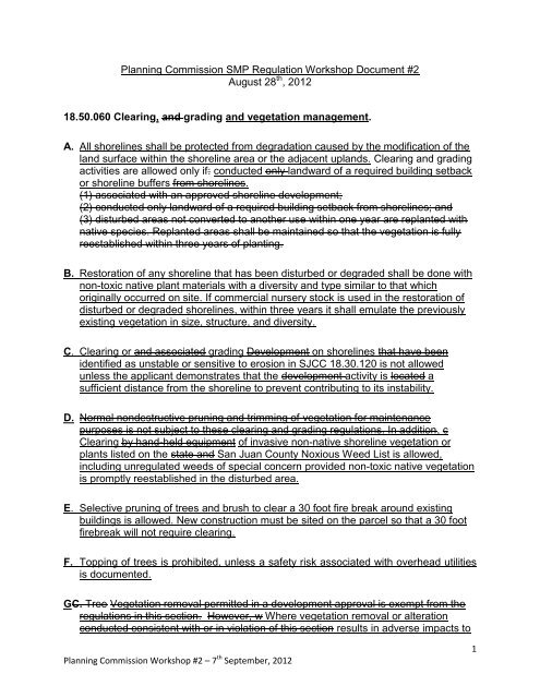
Planning Commission SMP Regulation Workshop Document #2<br />
August 28 th , 2012<br />
18.50.060 Clearing, and grading and vegetation management.<br />
A. All shorelines shall be protected from degradation caused by the modification <strong>of</strong> the<br />
land surface within the shoreline area or the adjacent uplands. Clearing and grading<br />
activities are allowed only if: conducted only landward <strong>of</strong> a required building setback<br />
or shoreline buffers from shorelines.<br />
(1) associated with an approved shoreline development;<br />
(2) conducted only landward <strong>of</strong> a required building setback from shorelines; and<br />
(3) disturbed areas not converted <strong>to</strong> another use within one year are replanted with<br />
native species. Replanted areas shall be maintained so that the vegetation is fully<br />
reestablished within three years <strong>of</strong> planting.<br />
B. Res<strong>to</strong>ration <strong>of</strong> any shoreline that has been disturbed or degraded shall be done with<br />
non-<strong>to</strong>xic native plant materials with a diversity and type similar <strong>to</strong> that which<br />
originally occurred on site. If commercial nursery s<strong>to</strong>ck is used in the res<strong>to</strong>ration <strong>of</strong><br />
disturbed or degraded shorelines, within three years it shall emulate the previously<br />
existing vegetation in size, structure, and diversity.<br />
C. Clearing or and associated grading Development on shorelines that have been<br />
identified as unstable or sensitive <strong>to</strong> erosion in SJCC 18.30.120 is not allowed<br />
unless the applicant demonstrates that the development activity is located a<br />
sufficient distance from the shoreline <strong>to</strong> prevent contributing <strong>to</strong> its instability.<br />
D. Normal nondestructive pruning and trimming <strong>of</strong> vegetation for maintenance<br />
purposes is not subject <strong>to</strong> these clearing and grading regulations. In addition, c<br />
Clearing by hand-held equipment <strong>of</strong> invasive non-native shoreline vegetation or<br />
plants listed on the state and San Juan County Noxious Weed List is allowed,<br />
including unregulated weeds <strong>of</strong> special concern provided non-<strong>to</strong>xic native vegetation<br />
is promptly reestablished in the disturbed area.<br />
E. Selective pruning <strong>of</strong> trees and brush <strong>to</strong> clear a 30 foot fire break around existing<br />
buildings is allowed. New construction must be sited on the parcel so that a 30 foot<br />
firebreak will not require clearing.<br />
F. Topping <strong>of</strong> trees is prohibited, unless a safety risk associated with overhead utilities<br />
is documented.<br />
GC. Tree Vegetation removal permitted in a development approval is exempt from the<br />
regulations in this section. However, w Where vegetation removal or alteration<br />
conducted consistent with or in violation <strong>of</strong> this section results in adverse impacts <strong>to</strong><br />
Planning Commission Workshop #2 – 7 th September, 2012<br />
1
shoreline ecological function, additional actions new developments or site alterations<br />
shall be required <strong>to</strong> develop and implement a mitigation plan that ensures no net<br />
loss <strong>of</strong> ecological functions per SJCC 18.50.070, Environmental Protection.<br />
Mitigation plans shall be prepared by a qualified pr<strong>of</strong>essional consistent with the<br />
requirements <strong>of</strong> SJCC 18.30.110. removal permitted in a development approval is<br />
exempt from the regulations in this section.<br />
HD. Commercial timber harvest conducted in accordance with an approved forest<br />
practices permit is exempt from the regulations in this section. (Ord. 2–1998 Exh. B<br />
§ 5.4.3) Activities covered under the Washing<strong>to</strong>n State Forest Practices Act, except<br />
for conversion <strong>to</strong> other uses and those other forest practice activities over which the<br />
County has authority, is exempt from these vegetation management standards.<br />
(See SJCC 18.50.240, Forest management)<br />
I. Aquatic weed control shall only occur when native plant communities and associated<br />
habitats are threatened or where an existing water dependent use is restricted by<br />
the presence <strong>of</strong> weeds. Aquatic weed control shall occur in compliance with all other<br />
applicable laws and standards.<br />
J. The control <strong>of</strong> aquatic weeds by hand pulling, mechanical harvesting that doesn’t<br />
disturb the sea bed, or placement <strong>of</strong> aqua-screens, if proposed <strong>to</strong> maintain existing<br />
water depth for navigation, shall be considered normal maintenance and repair and<br />
therefore exempt from the requirement <strong>to</strong> obtain a shoreline substantial development<br />
permit. (See the exemption procedures in SJCC 18.80.110(F).)<br />
K. The control <strong>of</strong> aquatic weeds by derooting, ro<strong>to</strong>vating, or other method which<br />
disturbs the sea bed bot<strong>to</strong>m sediment or benthos shall be a substantial development<br />
unless it will maintain existing water depth for navigation in an area covered by a<br />
previous permit for such activity. In that case, it shall be considered normal<br />
maintenance and repair.<br />
L. Use <strong>of</strong> herbicides <strong>to</strong> control aquatic weeds shall be prohibited except where no<br />
reasonable alternative exists and weed control complies with all state rules and<br />
regulations. (Ord. 2–1998 Exh. B § 5.4.10)<br />
18.50.130 Vegetation management. (Combined with Clearing and Grading above)<br />
A. All shorelines shall be protected from degradation caused by the modification <strong>of</strong> the<br />
land surface within the shoreline area or the adjacent uplands.<br />
B. Development on shorelines that have been identified as unstable or sensitive <strong>to</strong><br />
erosion in SJCC 18.30.120 is not allowed unless the applicant demonstrates that the<br />
development is located a sufficient distance from the shoreline <strong>to</strong> prevent<br />
contributing <strong>to</strong> its instability.<br />
C. Res<strong>to</strong>ration <strong>of</strong> any shoreline that has been disturbed or degraded shall be done with<br />
Planning Commission Workshop #2 – 7 th September, 2012<br />
2
native plant materials with a diversity and type similar <strong>to</strong> that which originally<br />
occurred on-site.<br />
D. Commercial nursery s<strong>to</strong>ck used in the res<strong>to</strong>ration <strong>of</strong> disturbed or degraded<br />
shorelines shall, at maturity, emulate the previously existing vegetation in size,<br />
structure, and diversity.<br />
E. Beach enhancement is prohibited:<br />
1. Within spawning, nesting, or breeding habitat;<br />
2. Where lit<strong>to</strong>ral drift <strong>of</strong> the enhancement materials will adversely effect adjacent<br />
spawning grounds or other areas <strong>of</strong> biological significance;<br />
3. If it will interfere with the normal public use <strong>of</strong> the navigable waters <strong>of</strong> the state;<br />
or<br />
4. Where the activity is in support <strong>of</strong> a nonconforming use unless such activities are<br />
necessary <strong>to</strong> maintain shoreline stability and the natural ecology.<br />
F. Aquatic weed control shall only occur when native plant communities and associated<br />
habitats are threatened or where an existing water dependent use is restricted by<br />
the presence <strong>of</strong> weeds. Aquatic weed control shall occur in compliance with all other<br />
applicable laws and standards.<br />
G. The control <strong>of</strong> aquatic weeds by hand pulling, mechanical harvesting, or placement<br />
<strong>of</strong> aqua-screens, if proposed <strong>to</strong> maintain existing water depth for navigation, shall be<br />
considered normal maintenance and repair and therefore exempt from the<br />
requirement <strong>to</strong> obtain a shoreline substantial development permit. (See the<br />
exemption procedures in SJCC 18.80.110(F).)<br />
H. The control <strong>of</strong> aquatic weeds by derooting, ro<strong>to</strong>vating, or other method which<br />
disturbs the bot<strong>to</strong>m sediment or benthos shall be a substantial development unless it<br />
will maintain existing water depth for navigation in an area covered by a previous<br />
permit for such activity. In that case, it shall be considered normal maintenance and<br />
repair.<br />
I. Use <strong>of</strong> herbicides <strong>to</strong> control aquatic weeds shall be prohibited except where no<br />
reasonable alternative exists and weed control complies with all state rules and<br />
regulations. (Ord. 2–1998 Exh. B § 5.4.10)<br />
18.50.140 View protection.<br />
A. <strong>Shoreline</strong> uses and activities must be designed and operated <strong>to</strong> avoid blocking or<br />
adversely interfering with visual access from public areas <strong>to</strong> the water and<br />
shorelines except as provided for in SJCC 18.50.130 060 Clearing, Grading and<br />
Vegetation Management.<br />
B. The vacation <strong>of</strong> public road ends and rights-<strong>of</strong>-way which provide visual access <strong>to</strong><br />
the water and shoreline may be allowed only in accordance with RCW 36.87.130<br />
and local rules.<br />
C. In providing visual access <strong>to</strong> the shoreline minor trimming and pruning <strong>of</strong> the foliage<br />
<strong>of</strong> trees and shrubs is allowed, provided the health <strong>of</strong> the trees and shrubs is<br />
Planning Commission Workshop #2 – 7 th September, 2012<br />
3
maintained, trees are not <strong>to</strong>pped, and all vegetation overhanging streams, lakes,<br />
wetlands, documented forage fish spawning beaches, and marine waters is retained.<br />
In no case shall more than 20% <strong>of</strong> the foliage <strong>of</strong> a tree or shrub be removed during<br />
one 12 month period. ,the natural vegetation shall not be excessively removed<br />
either by clearing or by <strong>to</strong>pping.<br />
D. In order <strong>to</strong> limit interference with views <strong>to</strong> the shoreline from surrounding properties<br />
<strong>to</strong> the shoreline and adjoining waters, development on or over the water shall be<br />
constructed only as far sea waterward as necessary for the intended use.<br />
E. Development on or over the water must be constructed <strong>of</strong> materials that are<br />
compatible in color with the surrounding area.<br />
F. Visual shoreline access must be maintained, enhanced, and preserved on public<br />
road ends and rights-<strong>of</strong>-way. (Ord. 2–1998 Exh. B § 5.4.11<br />
18.50.170 Agriculture.<br />
A. General Regulations.<br />
1. Buffers <strong>of</strong> permanent vegetation or other suitable soil erosion controls shall be<br />
established and maintained between tilled or grazed areas and associated water<br />
bodies. The type and extent <strong>of</strong> such vegetation and other control shall be <strong>of</strong> a<br />
width or character sufficient <strong>to</strong> prevent surface run<strong>of</strong>f and reduce siltation.<br />
2. Confined animal feeding operations, retention <strong>of</strong> s<strong>to</strong>rage ponds for feedlot<br />
wastes, and s<strong>to</strong>ckpiles <strong>of</strong> manure solids shall be located <strong>to</strong> prevent the pollution<br />
<strong>of</strong> water areas. Control guidelines prepared by the U.S. Environmental Protection<br />
Agency and state and local agencies shall be observed.<br />
3. Commercial feedlots shall not be permitted on the shorelines.<br />
4. All agricultural activities performed within watersheds for ground water collection<br />
or adjacent <strong>to</strong> shorelines shall develop a water quality conservation plan with the<br />
local USDA representative in line with “best management practices” and with the<br />
goal <strong>of</strong> protecting water quality. Agricultural activities conducted on agricultural<br />
resource lands will include the water quality plan as a portion <strong>of</strong> the five-year plan<br />
filed with the County assessor.<br />
4. New agricultural activities in the shoreline jurisdiction shall be located, designed,<br />
constructed, and managed <strong>to</strong> ensure no net loss <strong>of</strong> ecological functions and<br />
values.<br />
Planning Commission Workshop #2 – 7 th September, 2012<br />
4
B. Regulations by Designation Environment.<br />
1. Urban. Agricultural activities shall be permitted in the urban designation<br />
environment subject <strong>to</strong> the policies and regulations contained in this master<br />
program.<br />
2. Rural. Same as urban.<br />
3. Rural Residential. Same as urban.<br />
4. Rural Farm-Forest. Same as urban.<br />
5. Conservancy. Same as urban.<br />
6. Natural. Agricultural activities may be permitted in the natural designation<br />
environment as a conditional use; provided, that the resource which is <strong>to</strong> be<br />
protected by the natural designation will not be degraded.<br />
7. Aquatic. Agricultural activities shall not be allowed in the aquatic designation.<br />
proposed for the aquatic environment are considered <strong>to</strong> be aquacultural activities<br />
and the policies and regulations <strong>of</strong> SJCC 18.50.180, Aquaculture, shall govern.<br />
8. Ports, Marina and Transportation. Agricultural activities shall be permitted<br />
subject <strong>to</strong> the regulations <strong>of</strong> this SMP.<br />
8. Eastsound Urban, Eastsound Residential, Eastsound Marina District and<br />
Eastsound Conservancy. Same as urban.<br />
9. Eastsound Natural. Same as natural.<br />
10. Shaw Rural, Shaw Rural Farm-Forest and Shaw Conservancy. Same as<br />
urban.<br />
11. Shaw Natural. Same as natural. (Ord. 2–1998 Exh. B § 5.5.2)<br />
18.50.180 Aquaculture.<br />
Distinguishing between Aquaculture and Science.<br />
WAC 173-26-020 definitions defines Aquaculture as “means the culture or farming <strong>of</strong> fish, shellfish, or other<br />
aquatic plants and animals. Aquaculture does not include the harvest <strong>of</strong> wild geoduck associated with the<br />
state managed wilds<strong>to</strong>ck geoduck fishery.<br />
SJCC 18.20.010 defines aquaculture as ‘the science or art <strong>of</strong> cultivating fish, shellfish, or other aquatic animals<br />
or plants.’<br />
The current definition <strong>of</strong> aquaculture does not allow for scientific/res<strong>to</strong>ration activities that may use the same<br />
or similar in water structures as commercial fish pen operations. One option is for our code <strong>to</strong> distinguish<br />
between commercial and non-commercial activities, see below.<br />
Definition:<br />
Aquaculture is defined as the commercial or non-commercial science or art <strong>of</strong><br />
cultivating fish, shellfish, or other aquatic animals or plants.<br />
i. Commercial activities include the hatching, cultivating, planting, feeding,<br />
raising, harvesting, and processing <strong>of</strong> aquatic plants and animals and the<br />
maintenance and construction <strong>of</strong> necessary equipment, buildings and<br />
growing areas. Cultivation methods include but are not limited <strong>to</strong> fish pens,<br />
Planning Commission Workshop #2 – 7 th September, 2012<br />
5
fish hatcheries, shellfish rafts, racks and long lines, seaweed floats and<br />
nets and the culture <strong>of</strong> clams and oysters on tidelands and subtidal areas.<br />
ii.<br />
Non-commercial activities include harvesting fish, shellfish or other aquatic<br />
animals and plants for subsistence, recreational and personal<br />
consumption, and scientific research and/or res<strong>to</strong>ration activities.<br />
A. General Regulations.<br />
1. Because all shorelines within the County seaward <strong>of</strong> the line <strong>of</strong> extreme low tide<br />
have been designated “shorelines <strong>of</strong> statewide significance,” commercial<br />
aquacultural activities proposed in that area shall be subject <strong>to</strong>, first, the<br />
regulations policies referred <strong>to</strong> in SJCC 18.50.110, <strong>Shoreline</strong>s <strong>of</strong> statewide<br />
significance and second, the general and use-specific regulations contained in<br />
this chapter.<br />
2. No structures or facilities which would have a significant adverse impact on the<br />
natural, dynamic processes <strong>of</strong> shoreline formation and change shall be approved<br />
or constructed.<br />
3. No aquatic organism shall be introduced in<strong>to</strong> San Juan County salt or fresh<br />
waters without prior written approval <strong>of</strong> the Washing<strong>to</strong>n Department <strong>of</strong> Fish and<br />
Wildlife or the appropriate regula<strong>to</strong>ry agency for the specific organism proposed<br />
for introduction. The required approval shall be submitted in writing <strong>to</strong> Community<br />
Development and Planning (CD&P) permit center prior <strong>to</strong> the introduction or the<br />
granting <strong>of</strong> the permit, whichever comes first.<br />
4. The County shall not issue permits for projects that include the introduction <strong>of</strong><br />
aquatic organisms <strong>to</strong> salt waters until it has also requested written comment, and<br />
provided reasonable opportunity <strong>to</strong> comment on the proposed introduction, from<br />
the direc<strong>to</strong>r <strong>of</strong> the University <strong>of</strong> Washing<strong>to</strong>n Friday Harbor Labora<strong>to</strong>ries.<br />
5. Unless otherwise provided in the shoreline permit issued by the County, after a<br />
permit is issued the repeated introduction <strong>of</strong> an approved organism in the same<br />
location shall not require subsequent approval by the County. Introduction, for<br />
purposes <strong>of</strong> this section, shall mean the placing <strong>of</strong> any aquatic organism in any<br />
area within the waters <strong>of</strong> San Juan County regardless <strong>of</strong> whether it is a native or<br />
resident organism within the County and regardless <strong>of</strong> whether it is being<br />
transferred from within or without the waters <strong>of</strong> San Juan County.<br />
6. Aquacultural activities shall comply with all applicable governmental noise, air<br />
pollution, and water quality standards, including those in Chapter 18.60 SJCC. All<br />
activities shall be operated and maintained <strong>to</strong> minimize odor and noise.<br />
7. Aquacultural activities shall be restricted <strong>to</strong> reasonable hours, subject <strong>to</strong> tides,<br />
and days <strong>of</strong> operation, when necessary <strong>to</strong> minimize significant, adverse impacts<br />
from noise, light, and glare on nearby residents.<br />
8. Aquacultural structures and equipment, except navigation aids, shall be<br />
designed, operated, and maintained <strong>to</strong> blend in<strong>to</strong> their surroundings through the<br />
use <strong>of</strong> appropriate colors and materials.<br />
9. The County may require <strong>of</strong> commercial aquacultural permittees evidence <strong>of</strong><br />
Planning Commission Workshop #2 – 7 th September, 2012<br />
6
financial responsibility in an amount commensurate with the risk <strong>of</strong> injury or<br />
damage <strong>to</strong> any person, property, or environment as a result <strong>of</strong> the project.<br />
Evidence <strong>of</strong> financial responsibility shall not duplicate requirements <strong>of</strong> other<br />
agencies.<br />
10. Where aquacultural projects are authorized <strong>to</strong> use public facilities, such as boat<br />
launches or docks, the County shall reserve the right <strong>to</strong> require the applicant <strong>to</strong><br />
pay a portion <strong>of</strong> the cost <strong>of</strong> maintenance and any required improvements<br />
commensurate with the applicant’s use.<br />
11. All aquacultural structures and facilities shall be marked in accordance with U.S.<br />
Coast Guard requirements.<br />
12. Aquacultural structures and equipment shall be <strong>of</strong> sound construction and shall<br />
be maintained properly. Abandoned or unsafe structures and equipment shall be<br />
removed or repaired promptly by the owner. Where any structure might constitute<br />
a potential hazard <strong>to</strong> the public in the future, the County shall require evidence <strong>of</strong><br />
financial responsibility in an amount commensurate with the cost <strong>of</strong> removal or<br />
repair. The County will abate an abandoned or unsafe structure, following notice<br />
<strong>to</strong> the owner, if the owner fails <strong>to</strong> respond in 30 days. The County may take such<br />
action as necessary <strong>to</strong> enforce the financial responsibility <strong>of</strong> the applicant.<br />
Evidence <strong>of</strong> financial responsibility shall not duplicate requirements <strong>of</strong> other<br />
agencies.<br />
13. Applicants shall include in their applications all information needed <strong>to</strong> conduct<br />
thorough evaluations <strong>of</strong> their aquaculture proposals, including the following:<br />
a. Species <strong>to</strong> be reared.<br />
b. Aquaculture method(s).<br />
c. Anticipated use <strong>of</strong> any feed, pesticides, herbicides, antibiotics, or other<br />
substances, and their predicted impacts.<br />
d. Manpower or employment necessary for the project.<br />
e. Harvest and processing location, method, and timing.<br />
f. Location and plans for any shore-side activities, including loading and<br />
unloading <strong>of</strong> the product, processing, and any use <strong>of</strong> freshwater supplies.<br />
g. Methods <strong>of</strong> waste disposal and preda<strong>to</strong>r control.<br />
h. Environmental assessment, including best available background information<br />
on water quality, tidal variations, prevailing s<strong>to</strong>rm wind conditions, current<br />
flows, flushing rates, aquatic and benthic organisms, and probable impacts on<br />
water quality, macroalgae, biota, currents, lit<strong>to</strong>ral drift, and any existing<br />
shoreline or water uses. Further baseline studies may be required depending<br />
upon the adequacy <strong>of</strong> available information, existing conditions, the nature <strong>of</strong><br />
the proposal, and probable adverse environmental impacts. Baseline<br />
moni<strong>to</strong>ring shall be at the applicant’s expense unless otherwise provided for.<br />
i. Other pertinent information deemed necessary by the Direc<strong>to</strong>r administra<strong>to</strong>r.<br />
14. Legally established aquacultural enterprises, including authorized experimental<br />
projects, shall be protected from incompatible uses which may seek <strong>to</strong> locate<br />
nearby. Demonstration <strong>of</strong> a high probability that such an adjacent use would<br />
Planning Commission Workshop #2 – 7 th September, 2012<br />
7
esult in damage <strong>to</strong> or destruction <strong>of</strong> such an aquacultural enterprise shall be<br />
grounds for the denial <strong>of</strong> that use.<br />
15. Operational moni<strong>to</strong>ring <strong>of</strong> commercial aquacultural facilities may be required if<br />
and <strong>to</strong> the extent that it is necessary <strong>to</strong> determine, ensure, or confirm compliance<br />
with predicted or required performance. Such moni<strong>to</strong>ring requirements shall be<br />
established as a condition <strong>of</strong> the permit and shall be conducted at the applicant’s<br />
or opera<strong>to</strong>r’s expense.<br />
16. No processing <strong>of</strong> any commercial aquacultural product, except for the sorting or<br />
culling <strong>of</strong> the cultured organism and the washing or removal <strong>of</strong> surface materials<br />
or organisms, shall occur in or over the water after harvest, unless specifically<br />
approved by permit. All other processing and processing facilities shall be<br />
located on land and shall be governed by the policies and regulations <strong>of</strong> SJCC<br />
18.50.310, Ports and water-related port facilities (this reference will need <strong>to</strong><br />
change), in addition <strong>to</strong> the policies and regulations in this section.<br />
17. Aquacultural wastes must be disposed <strong>of</strong> in a manner that will ensure<br />
compliance with all applicable governmental waste disposal standards. No<br />
garbage, wastes, or debris shall be allowed <strong>to</strong> accumulate at the site <strong>of</strong> any<br />
aquaculture operation.<br />
18. Commercial Aaquacultural uses and facilities must be located at least 600 feet<br />
from any National Wildlife Refuge lands or habitats <strong>of</strong> special significance for<br />
birds or mammals (as identified in recognized reference documents, such as the<br />
Washing<strong>to</strong>n Department <strong>of</strong> Ecology publication, “Washing<strong>to</strong>n Coastal Areas <strong>of</strong><br />
Major Biological Significance,” or as determined by the Washing<strong>to</strong>n Department<br />
<strong>of</strong> Fish and Wildlife).<br />
19. Commercial Ffish net-pens and projects involving substantial substrate<br />
modification shall be located 1,500 feet or more from such areas; however,<br />
lesser distances may be authorized by permit if it is demonstrated by the<br />
applicant that the wildlife resource will be protected and if the exception is<br />
supported by the reviewing resource agencies. Greater distances also may be<br />
required if supported by the reviewing resource agencies.<br />
2019. Preda<strong>to</strong>r control shall not involve the killing or abusive harassment <strong>of</strong> birds<br />
or mammals. Approved controls include but are not limited <strong>to</strong> double netting for<br />
seals, overhead netting for birds, and three-foot-high fencing or netting for otters.<br />
The use <strong>of</strong> other nonlethal, nonabusive preda<strong>to</strong>r control measures shall be<br />
contingent upon receipt <strong>of</strong> written approval from the National Marine Fisheries<br />
Service or the U.S. Fish and Wildlife Service, as required.<br />
210. Permit applications shall identify all pesticides, herbicides, antibiotics,<br />
vaccines, growth stimulants, anti-fouling agents, or other chemicals the applicant<br />
anticipates using. No such materials shall be used until approval is obtained from<br />
all appropriate state and federal agencies, including the U.S. Food and Drug<br />
Administration, the Washing<strong>to</strong>n Departments <strong>of</strong> Ecology, Fish and Wildlife, and<br />
Agriculture, as required, and pro<strong>of</strong> <strong>of</strong> such approvals is submitted <strong>to</strong> the County.<br />
When feasible, the cleaning <strong>of</strong> nets and other apparatus shall be accomplished<br />
by air drying, spray washing, or hand washing.<br />
221. For commercial aquacultural projects using over-water structures, s<strong>to</strong>rage<br />
Planning Commission Workshop #2 – 7 th September, 2012<br />
8
<strong>of</strong> necessary <strong>to</strong>ols and apparatus seaward <strong>of</strong> the ordinary high water mark shall<br />
be limited <strong>to</strong> containers <strong>of</strong> not more than three feet in height, as measured from<br />
the surface <strong>of</strong> the raft or dock. However, in locations where the visual impact <strong>of</strong><br />
the proposed commercial aquaculture structures will be minimal, the County may<br />
authorize s<strong>to</strong>rage containers <strong>of</strong> greater height. In such cases, the burden <strong>of</strong> pro<strong>of</strong><br />
shall be on the applicant. Materials which are not necessary for the immediate<br />
and regular operation <strong>of</strong> the facility shall not be s<strong>to</strong>red seaward <strong>of</strong> the ordinary<br />
high water mark.<br />
232. Proposals for mechanical clam harvesting or other activities that involve<br />
substantial substrate modification through dredging, trenching, digging, or<br />
adverse sedimentation shall not be allowed in existing kelp beds or in beds <strong>of</strong><br />
native eel grass (Zostera marina) containing more than two turions per onequarter<br />
square meter in winter or three turions per one-quarter square meter in<br />
summer.<br />
243. Fish net-pens shall meet, as a minimum, state-approved administrative<br />
guidelines for the management <strong>of</strong> net-pen cultures. Where any conflict in<br />
requirements arises, the more stringent requirement shall prevail.<br />
254. Fish net-pens shall not occupy more than two surface acres <strong>of</strong> water area,<br />
excluding booming and anchoring requirements.<br />
265. Commercial A aquacultural proposals that include net pens or rafts shall<br />
not be located closer than one nautical mile <strong>to</strong> any other commercial aquacultural<br />
facility that includes net pens or rafts. However, a lesser distance may be<br />
authorized by the County if the applicant can demonstrate <strong>to</strong> the County’s<br />
satisfaction that the ecological environmental and aesthetic concerns expressed<br />
in this SMP will be protected. If a lesser distance is requested, the burden <strong>of</strong><br />
pro<strong>of</strong> shall be on the applicant <strong>to</strong> demonstrate that the structures, s<strong>to</strong>rage <strong>of</strong><br />
necessary <strong>to</strong>ols and apparatus seaward <strong>of</strong> the ordinary high water mark shall be<br />
limited <strong>to</strong> containers <strong>of</strong> not more than three feet in height, as measured from the<br />
surface <strong>of</strong> the raft, or that the cumulative impacts <strong>of</strong> the existing and proposed<br />
operations would not be contrary <strong>to</strong> the policies and regulations <strong>of</strong> this SMP.<br />
276. Except as provided in subsection (A)(22) <strong>of</strong> this section, aquacultural<br />
developments approved on an experimental basis shall not exceed five acres in<br />
area (except anchorage for floating systems) and five years in duration. The<br />
County may, however, issue a new permit <strong>to</strong> continue an experimental project as<br />
many times as is deemed necessary and appropriate.<br />
287. Where necessary <strong>to</strong> preserve the integrity <strong>of</strong> any research data collected,<br />
commercial aquaculture developments which would be likely <strong>to</strong> jeopardize an<br />
non-commercial experimental aquaculture development project shall not be<br />
allowed within the same bay, harbor, or cove with any such non-commercial<br />
aquaculture project development, or within a mile <strong>of</strong> such a development if the<br />
water body is larger than one square mile in area, until after the experimental<br />
project is granted non-experimental status or terminated.<br />
298. For commercial floating culture facilities, the County shall reserve the right<br />
<strong>to</strong> require a visual impact analysis consisting <strong>of</strong> information comparable <strong>to</strong> that<br />
found in the Washing<strong>to</strong>n Department <strong>of</strong> Ecology’s “Aquacultural Siting Study” <strong>of</strong><br />
Planning Commission Workshop #2 – 7 th September, 2012<br />
9
1986.<br />
3029. For all commercial aquacultural development projects that would be likely<br />
<strong>to</strong> affect water quality or quantity affecting a permitted and currently established<br />
commercial aquaculture project, a separate administrative review shall be<br />
completed prior <strong>to</strong> issuing any development permit. The Direc<strong>to</strong>r administra<strong>to</strong>r<br />
may request research or analysis, as necessary, by appropriate experts such as<br />
hydrologists or marine biologists, <strong>to</strong> assist in determining that marine water<br />
quality impacts will not damage or destroy the established aquaculture use,<br />
based on a preponderance <strong>of</strong> the evidence. No development permit shall be<br />
granted if the established aquaculture operation will likely be damaged or<br />
destroyed based on a preponderance <strong>of</strong> the evidence.<br />
B. Regulations by Designation Environment.<br />
1. Urban. Aquacultural activities shall be permitted in the urban designation<br />
environment subject <strong>to</strong> the policies and regulations <strong>of</strong> this master program.<br />
2. Rural. Aquacultural activities shall be permitted in the rural general use<br />
designation environment subject <strong>to</strong> the policies and regulations <strong>of</strong> this SMP;<br />
provided, that the proposed structures and facilities will not have a significant<br />
adverse impact on the aesthetic qualities <strong>of</strong> the surrounding area.<br />
3. Rural Residential. Aquacultural activities shall be permitted as a shoreline<br />
conditional use in the rural residential designation environment subject <strong>to</strong> the<br />
policies and regulations <strong>of</strong> this SMP; provided, that the proposed structures and<br />
facilities will not have a significant adverse impact on the aesthetic qualities and<br />
ecological functions and values <strong>of</strong> the surrounding area. Proposals containing<br />
nNet-pen facilities shall be located no closer than 1,500 feet waterward <strong>of</strong> from<br />
the OHWM <strong>of</strong> this designation environment, unless a lesser distance is<br />
determined <strong>to</strong> be appropriate based upon a visual impact analysis. Other types <strong>of</strong><br />
floating aquaculture facilities may be located within 1,500 feet <strong>of</strong> the OHWM but<br />
in such cases a visual analysis and an assessment <strong>of</strong> the activity’s potential<br />
impacts on the ecological functions and values shall be manda<strong>to</strong>ry.<br />
4. Rural Farm-Forest. Same as rural.<br />
5. Conservancy. Aquacultural activities shall be permitted in the conservancy<br />
designation environment subject <strong>to</strong> the policies and regulations <strong>of</strong> this SMP;<br />
provided, that the natural ecological functions and values resources and systems<br />
<strong>of</strong> the environment will not be significantly altered; and provided further, that the<br />
required structures and facilities, both terrestrial and aquatic, will not have a<br />
significant adverse impact on the aesthetic qualities <strong>of</strong> the surrounding area.<br />
6. Natural. Aquacultural activities that do not require structures or facilities or<br />
mechanized harvest practices and that will not result in the alteration <strong>of</strong> natural<br />
systems or features shall be permitted in the natural designation environment<br />
subject <strong>to</strong> the policies and regulations contained in this SMP.<br />
7. Aquatic. Aquacultural activities shall be permitted in the aquatic designation<br />
environment provided the activities do not conflict with other established aquatic<br />
designation uses including navigation, moorage, sport or commercial fishing, log<br />
rafting, under water utilities, other water dependent activities. subject <strong>to</strong> the<br />
policies and regulations <strong>of</strong> this SMP and <strong>to</strong> the regulations by environment<br />
Planning Commission Workshop #2 – 7 th September, 2012<br />
10
applicable <strong>to</strong> the most restrictive abutting shoreline environment, <strong>to</strong> be<br />
determined on a case-by-case basis but <strong>to</strong> be considered generally as the<br />
shoreline environment visible within 1,500 feet <strong>of</strong> a project site; provided, that the<br />
policies and regulations <strong>of</strong> a less restrictive abutting environment may be<br />
substituted if the administra<strong>to</strong>r determines that the public interest would not be<br />
compromised by doing so.<br />
8. Ports, Marinas and Transportation. Aquacultural activities are incompatible<br />
with the goal and uses prevalent in the Ports, Marinas and Transportation<br />
designation and are prohibited in this designation.<br />
8. Eastsound Urban, Eastsound Residential, and Eastsound Marina. Same as<br />
urban.<br />
9. Eastsound Conservancy. Same as conservancy.<br />
10. Eastsound Natural. Same as natural.<br />
11. Shaw Rural and Shaw Rural Farm-Forest. Same as rural.<br />
12. Shaw Conservancy. Same as conservancy.<br />
13. Shaw Natural. Same as natural. (Ord. 7-2005 § 11 & 12; Ord. 2–1998 Exh. B §<br />
5.5.3<br />
18.50.240 Forest management.<br />
A. General Regulations.<br />
1. Any commercial logging permitted on shorelines shall comply with the regulations<br />
contained in the Washing<strong>to</strong>n State Forest Practices Act, Chapter 76.09 RCW;<br />
rules implementing the Forest Practices Act in WAC 222; and the 1999 Forest<br />
and Fish Report; provided, that the following regulations shall also apply <strong>to</strong> Class<br />
IV-General forest practices where shorelines are being converted or are<br />
expected <strong>to</strong> be converted <strong>to</strong> non-forest uses.<br />
2. Forest practice conversions and other Class IV-General forest practices where<br />
there is a likelihood <strong>of</strong> conversion <strong>to</strong> non-forest uses shall assure no net loss <strong>of</strong><br />
shoreline ecological functions; shall maintain the ecological quality <strong>of</strong> the<br />
watershed’s hydrologic system; and shall prevent significant adverse impacts <strong>to</strong><br />
other shoreline uses, resources and values provided for in RCW 90.58.020 such<br />
as navigation, recreation and public access.<br />
32. When a logging project involves drilling, dredging, dumping, filling, removal <strong>of</strong><br />
sand or gravel, bulkheading, or significant construction, all or part <strong>of</strong> which would<br />
be located within 200 feet <strong>of</strong> the ordinary high water mark, a substantial<br />
development permit is required.<br />
43. A logging project which includes construction <strong>of</strong> roads, bridges, trails, or loading<br />
facilities would potentially require a substantial development permit if it involves<br />
any <strong>of</strong> the activities noted in subsection (A)(2) <strong>of</strong> this section.<br />
4. No more than 30 percent <strong>of</strong> merchantable timber may be harvested within 200<br />
feet <strong>of</strong> the ordinary high water mark within any 10-year period. Harvesting shall<br />
not be allowed within 75 feet <strong>of</strong> the OHWM; provided, that merchantable timber<br />
within this protected area may be included in the 30 percent calculation for the<br />
shoreline area. Clearcutting on shorelines shall not be permitted unless<br />
Planning Commission Workshop #2 – 7 th September, 2012<br />
11
specifically allowed by an approved Class IV General forest practices permit.<br />
5. All roads and trails must be fitted <strong>to</strong> the existing <strong>to</strong>pography so that the need <strong>to</strong><br />
alter natural features will be minimized. Steep or unstable areas, regulated<br />
wetlands, and natural drainageways must be avoided.<br />
6. All road surfaces must be constructed <strong>to</strong> the minimum width required <strong>to</strong><br />
accommodate the anticipated use.<br />
7. Unnecessary road construction and drainageway crossings must be minimized<br />
by making all possible use <strong>of</strong> existing roads. Where roads pass through land in<br />
another ownership, but would otherwise adequately serve the proposed<br />
operation, the applicant must attempt <strong>to</strong> secure the right <strong>to</strong> use the existing road<br />
before proposing the construction <strong>of</strong> a new road.<br />
8. Road cuts and fills must be balanced or waste or borrow areas must be located<br />
where erosion will not present a problem. Cuts and fills must be constructed at or<br />
below the normal angle <strong>of</strong> repose for the material being cut or used for fill. Fill<br />
slopes must not obstruct drainageways and shall be properly compacted.<br />
9. Where culverts must be installed, they shall be adequate in size and design <strong>to</strong><br />
carry the anticipated peak flow and shall be kept free <strong>of</strong> obstructions.<br />
10. Road drainage, regardless <strong>of</strong> the method <strong>of</strong> collection, must be directed on<strong>to</strong> the<br />
forest or woodlot floor in a manner which will permit the accumulated sediment <strong>to</strong><br />
settle and be deposited before the water reaches any marine or freshwater body.<br />
11. Drainageways must be cleared <strong>of</strong> all debris generated during road construction<br />
or maintenance which might interfere with normal drainage or adversely affect<br />
water quality.<br />
12. Road construction must be undertaken during that portion <strong>of</strong> the year when soil<br />
erosion does not pose a serious problem. When this is not practical, acceptable<br />
measures for the prevention <strong>of</strong> erosion shall be taken. (Items 6-12 have been<br />
moved <strong>to</strong> the roads subsection <strong>of</strong> transportation section <strong>of</strong> the smp.)<br />
613. Roads must be maintained sufficiently <strong>to</strong> ensure the proper functioning <strong>of</strong><br />
the drainage system throughout the active use <strong>of</strong> the road. When active use is <strong>to</strong><br />
be discontinued, the road shall be left in a condition which will provide for<br />
adequate drainage and soil stability without continuous active maintenance.<br />
714. Within study areas one 1 through 12 <strong>of</strong> the San Juan County Inven<strong>to</strong>ry <strong>of</strong><br />
Natural Areas, forest practices not exempted from the <strong>Shoreline</strong> Management<br />
Act under Chapter 76.09 RCW may be permitted only as conditional uses.<br />
815. Soil stabilization and water quality maintenance along seasonal<br />
waterways and other significant drainageways must be provided for by leaving<br />
buffer strips <strong>of</strong> ground vegetation and nonmerchantable timber along such<br />
watercourses. Where insufficient nonmerchantable timber exists <strong>to</strong> maintain an<br />
effective buffer zone, an adequate fringe <strong>of</strong> merchantable timber must be left<br />
undisturbed. Where it is impractical <strong>to</strong> leave buffer strips <strong>of</strong> either merchantable<br />
or nonmerchantable timber along watercourses, a plan <strong>to</strong> reestablish adequate<br />
cover must be approved by the County.<br />
916. Logging and log dumping is not permitted on or immediately above feeder<br />
Planning Commission Workshop #2 – 7 th September, 2012<br />
12
luffs.<br />
107. Trees shall be felled, bucked, and limbed so that no part <strong>of</strong> any tree shall<br />
be deposited in<strong>to</strong> or across any watercourse. If any timber or debris should enter<br />
the watercourse as a result <strong>of</strong> the logging activity, it shall be removed<br />
immediately in a manner which will disturb the watercourse as little as possible.<br />
118. Trac<strong>to</strong>r skids must be located carefully and drained adequately so that<br />
sediment will be kept out <strong>of</strong> watercourses and water bodies. Trac<strong>to</strong>r yarding is<br />
prohibited on unstable slopes and on slopes in excess <strong>of</strong> 30 percent. Cable<br />
yarding through watercourses is prohibited.<br />
129. Timber harvesting is prohibited on slopes where significant erosion and<br />
sedimentation would be precipitated unless a plan for adequate and prompt<br />
erosion control and res<strong>to</strong>ration is approved by the County.<br />
1320. All nonorganic waste materials resulting from the logging operations, such<br />
as grease and oil containers, and machine parts, must be disposed <strong>of</strong> in a proper<br />
<strong>of</strong>f-site location immediately following termination <strong>of</strong> the harvesting operations. At<br />
no time may such waste materials be disposed <strong>of</strong> in watercourses or water<br />
bodies.<br />
1421. Conversion option harvest plan (COHP) forest practices are not permitted<br />
in the shoreline.<br />
1522. Timber harvest in areas <strong>of</strong> exposed bedrock along shorelines, and in other<br />
areas <strong>of</strong> high visual value and sensitivity, as identified in the Open Space and<br />
Conservation Plan or SJCC 18.30.110, shall be avoided where possible.<br />
B. Regulations by Designation Environment.<br />
1. Urban. Forest management practices shall be permitted in the urban<br />
environment only as a conditional use.<br />
2. Rural and Rural Residential. Same as urban.<br />
3. Rural Farm-Forest. Forest management practices shall be permitted in the rural<br />
environments subject <strong>to</strong> the policies and regulations contained in this SMP.<br />
4. Conservancy. Same as rural farm-forest.<br />
15. Natural. Forest management practices are permitted as a conditional use in the<br />
Nnatural designation environment only when no other means <strong>of</strong> control will work<br />
<strong>to</strong> control a fire, halt the spread <strong>of</strong> disease or damaging insects, or <strong>to</strong> clean up<br />
and res<strong>to</strong>re an area devastated by a natural disaster such as fire, s<strong>to</strong>rm, disease,<br />
or insect attack. No roads may be constructed except those which are absolutely<br />
necessary <strong>to</strong> cope with the emergency situation.<br />
6. Aquatic. Forest management practices are prohibited in the aquatic<br />
environment.<br />
8. Ports, Marinas and Transportation. Forest management practices shall be<br />
permitted as a conditional use.<br />
7. Eastsound Urban, Eastsound Residential, Eastsound Marina District and<br />
Eastsound Conservancy. Same as urban.<br />
8. Eastsound Natural. Same as natural.<br />
9. Shaw Rural, Shaw Rural Farm-Forest and Shaw Conservancy. Same as rural<br />
Planning Commission Workshop #2 – 7 th September, 2012<br />
13
farm-forest unless otherwise specified in the Shaw Island Subarea Plan.<br />
10. Shaw Natural. Same as natural. (Ord. 7-2005 § 14; Ord. 2–1998 Exh. B § 5.5.9)<br />
18.50.270 Fill and Excavation Landfills and solid waste disposal.<br />
1. Landfills may be permitted only as conditional uses.<br />
A. All fills and excavations shall be located, designed and constructed <strong>to</strong> protect<br />
shoreline ecological functions and ecosystem-wide processes.<br />
B. Fill and excavation shall be minimized <strong>to</strong> the maximum extent practicable and<br />
necessary <strong>to</strong> accommodate approved shoreline uses and development activities that<br />
are consistent with this SMP. When fill or excavation causes adverse impacts <strong>to</strong><br />
ecological functions, a mitigation plan must be prepared and implemented consistent<br />
with SJCC 18.30.110.<br />
C. Fill and excavation within wetlands or waterward <strong>of</strong> the OHWM shall only be<br />
permitted in limited instances for the following purposes and when other required<br />
state or federal permits have been obtained and with consideration given <strong>to</strong> specific<br />
site conditions.<br />
1. Water-dependent uses, public access, and cleanup and disposal <strong>of</strong> contaminated<br />
sediments as part <strong>of</strong> an interagency environmental clean-up plan;<br />
2. Disposal <strong>of</strong> dredged material considered suitable under, and conducted in<br />
accordance with, the Dredged Material Management <strong>Program</strong> <strong>of</strong> the Department<br />
<strong>of</strong> Natural Resources and/or the Dredged Material Management Office <strong>of</strong> the<br />
U.S. Army Corps <strong>of</strong> Engineers (see SJCC 18.50.230, Dredging);<br />
3. Expansion or alteration <strong>of</strong> transportation facilities <strong>of</strong> statewide significance<br />
currently located on the shoreline where alternatives <strong>to</strong> fill are infeasible;<br />
4. Ecological res<strong>to</strong>ration or enhancement, including, but not limited <strong>to</strong>, beach<br />
nourishment, habitat creation, culvert upgrades <strong>to</strong> improve fish and flow passage,<br />
or bank res<strong>to</strong>ration when consistent with the res<strong>to</strong>ration plan approved as part <strong>of</strong><br />
this SMP; or<br />
5. Protection <strong>of</strong> cultural or his<strong>to</strong>ric resources when fill is the most feasible method <strong>to</strong><br />
avoid continued degradation, disturbance or erosion <strong>of</strong> a site. Such fills must be<br />
coordinated with any affected tribes and comply with applicable provisions <strong>of</strong><br />
SJCC 18.50.050, Archaeological and His<strong>to</strong>ric Resources.<br />
D. All fills and excavation waterward <strong>of</strong> the OHWM not associated with ecological<br />
res<strong>to</strong>ration shall require a shoreline conditional use permit.<br />
E. All other upland fills are permitted provided they are conducted outside required<br />
buffers or setbacks and are part <strong>of</strong> an approved shoreline use or modification or are<br />
necessary <strong>to</strong> provide protection <strong>to</strong> cultural or his<strong>to</strong>ric resources, are the minimum<br />
necessary <strong>to</strong> implement the approved use or modification, do not significantly<br />
change the <strong>to</strong>pography <strong>of</strong> the landscape in a manner that affects the hydrology or<br />
Planning Commission Workshop #2 – 7 th September, 2012<br />
14
increases the risk <strong>of</strong> slope failure, and are consistent with applicable provisions <strong>of</strong><br />
SJCC 18.30.110 through 18.30.160,<br />
F. Fills or excavation shall not be located where shoreline stabilization will be<br />
necessary <strong>to</strong> protect materials placed or removed, except when part <strong>of</strong> an approved<br />
plan for protection <strong>of</strong> cultural resources.<br />
G. Fills, beach nourishment and excavation shall be designed <strong>to</strong> blend physically and<br />
visually with existing <strong>to</strong>pography whenever possible, so as not <strong>to</strong> interfere with water<br />
dependent uses, lawful access and enjoyment <strong>of</strong> scenery.<br />
H. A temporary erosion and sediment control (TESC) plan, including BMPs, consistent<br />
with the 2005/2012 (current) S<strong>to</strong>rmwater Management Manual for Western<br />
Washing<strong>to</strong>n shall be provided for all proposed fill and excavation activities, and<br />
approved by the County prior <strong>to</strong> commencement <strong>of</strong> activity. Disturbed areas shall be<br />
immediately protected from erosion using weed-free straw, mulches, hydroseed, or<br />
similar methods and revegetated as applicable.<br />
2. The perimeters <strong>of</strong> all landfills shall include some means <strong>to</strong> control erosion and<br />
contain sediment, such as vegetation or retaining walls.<br />
3. <strong>Shoreline</strong> areas shall not be considered for sanitary landfills or for the disposal <strong>of</strong><br />
solid waste.<br />
I4. Applications for substantial development permits which include landfilling shall<br />
include at least the following information:<br />
1a. Source <strong>of</strong> landfill material;<br />
2b. Physical characteristics <strong>of</strong> landfill material;<br />
3c. <strong>Proposed</strong> methods <strong>of</strong> placement and compaction;<br />
4d. <strong>Proposed</strong> surfacing material;<br />
5e. <strong>Proposed</strong> method(s) <strong>of</strong> perimeter erosion control; and<br />
6f. <strong>Proposed</strong> use <strong>of</strong> filled area.<br />
B. Regulations by Designation Environment.<br />
1. Urban, Rural, Rural Residential and Rural Farm-Forest. Landf Fills shall be<br />
allowed in these environments subject <strong>to</strong> the policies and regulations <strong>of</strong> this<br />
SMP; provided, that landfills shall not be permitted below the OHWM; and<br />
provided further, landfills shall not be permitted for the sole purpose <strong>of</strong> creating<br />
additional land area.<br />
2. Conservancy. Same as urban; provided, that landfills shall not be permitted on<br />
natural (as opposed <strong>to</strong> manmade, privately owned) lakes; and provided further,<br />
that retaining walls shall not be used as an erosion control device on permitted<br />
landfills.<br />
3. Natural. Landf Fills are prohibited in the natural designation environment.<br />
Planning Commission Workshop #2 – 7 th September, 2012<br />
15
4. Aquatic. Landf Fills shall be permitted in the aquatic designation environment<br />
subject <strong>to</strong> the policies and regulations <strong>of</strong> this SMP and subject <strong>to</strong> the regulations<br />
by designation environment for the abutting shoreline designation environment.<br />
Where a proposed landfill site abuts more than one shoreline designation<br />
environment the provisions <strong>of</strong> the more restrictive designation environment shall<br />
govern.<br />
5. Eastsound Urban, Eastsound Residential, and Eastsound Marina District.<br />
Same as urban.<br />
6. Eastsound Conservancy and Eastsound Natural. Landfills are prohibited in<br />
these environments.<br />
7. Shaw Rural and Shaw Rural Farm-Forest. Same as urban.<br />
8. Shaw Conservancy and Shaw Natural. Landfills are prohibited in these<br />
environments. (Ord. 2–1998 Exh. B § 5.5.12)<br />
18.50.280 Log transfer facilities, sites and facilities and log s<strong>to</strong>rage.<br />
A. Regulations.<br />
1. Dry land log s<strong>to</strong>rage shall be preferred over water s<strong>to</strong>rage unless the applicant<br />
demonstrates that in-water s<strong>to</strong>rage will be less detrimental <strong>to</strong> the natural<br />
environment.<br />
2. Unpaved areas which have seasonal high water tables (less than three feet<br />
below ground surface) or poor surface drainage shall not be used for log s<strong>to</strong>rage<br />
during the wet season unless specifically authorized by the Direc<strong>to</strong>r administra<strong>to</strong>r<br />
following investigation <strong>of</strong> the site.<br />
3. Log s<strong>to</strong>rage is not permitted in public waters where state and federal quality<br />
standards cannot be met at all times, nor where such s<strong>to</strong>rage would constitute a<br />
significant hindrance <strong>to</strong> other legitimate water uses such as small craft<br />
navigation.<br />
4. In conformance with Washing<strong>to</strong>n Department <strong>of</strong> Natural Resources (WDNR)<br />
established policy, log rafting, transfer, and s<strong>to</strong>rage areas on leased public<br />
tidelands shall be used cooperatively and jointly by loggers and not exclusively<br />
by the leaseholder.<br />
5. In conformance with WDNR established policy, (“Special Provisions for Booming<br />
and Rafting Leases,” 17–2–72) easy-let-down devices shall be preferred over the<br />
free dumping <strong>of</strong> logs in<strong>to</strong> the water. However, in no event shall the free-fall<br />
dumping <strong>of</strong> logs be permitted in a manner which would do unnecessary damage<br />
<strong>to</strong> the shoreline ecological functions and values life forms.<br />
6. Effective bark and wood debris controls and collection and disposal methods<br />
must be employed at log s<strong>to</strong>rage and raft construction areas for both floating and<br />
sinking particles.<br />
7. Drainage and surface run<strong>of</strong>f from log s<strong>to</strong>rage areas must be controlled so that<br />
pollutants, including bark and other wood debris, will not be carried in<strong>to</strong> water<br />
bodies.<br />
8. Dikes, drains, vegetated buffer strips, or other means shall be used <strong>to</strong> ensure<br />
that surface run<strong>of</strong>f is collected and discharged from the s<strong>to</strong>rage area at one<br />
Planning Commission Workshop #2 – 7 th September, 2012<br />
16
point. It must be demonstrated that state water quality standards or criteria will<br />
not be violated by such run<strong>of</strong>f discharge under any conditions <strong>of</strong> flow in nearby<br />
water courses. If such demonstration is not possible, treatment facilities for run<strong>of</strong>f<br />
shall be provided meeting state and federal standards.<br />
9. Where water depths will permit the floating <strong>of</strong> bundled logs, they must be<br />
secured in bundles on land before being placed in the water. Bundles shall not<br />
be broken again except on land or at mill-sites.<br />
10. Log transfer facilities will not be approved until:<br />
a. It can be shown by the applicant that existing facilities are not adequate or<br />
feasible for use;<br />
b. Alternative access is not adequate or feasible;<br />
c. The feasibility and determination <strong>of</strong> demand for a multiple-user facility has<br />
been thoroughly investigated; and<br />
d. The applicant has the burden <strong>of</strong> providing the information requested for<br />
subsections (A)(10)(a) through (c) <strong>of</strong> this section, and must provide this<br />
information in a manner prescribed by the Direc<strong>to</strong>r administra<strong>to</strong>r.<br />
11. The development <strong>of</strong> a facility for log transfer, or the use <strong>of</strong> an unimproved<br />
shoreline area for a log transfer site, shall be subject <strong>to</strong> conditional use.<br />
12. Proposals for commercial timber harvest on islands not served by Washing<strong>to</strong>n<br />
State Ferries shall identify all sites that are proposed for the transfer <strong>of</strong> logs <strong>of</strong>f <strong>of</strong><br />
the islands. A shoreline conditional use permit is required for each log transfer<br />
site; however, the ongoing use <strong>of</strong> a legally operating, single transfer site on a<br />
given non-ferry-served island shall not require a separate shoreline permit for<br />
each user.<br />
B. Regulations by Designation Environment.<br />
1. Urban. Log handling and s<strong>to</strong>rage facilities and log transfer sites and facilities<br />
shall be permitted in the urban designation environment subject <strong>to</strong> the policies<br />
and regulations <strong>of</strong> this SMP.<br />
2. Rural and Rural Residential. Log handling and s<strong>to</strong>rage facilities and log transfer<br />
sites and facilities shall be allowed only on non-ferry-served islands and if the site<br />
will serve multiple users on the island affected, subject <strong>to</strong> the policies and<br />
regulations <strong>of</strong> this SMP.<br />
3. Rural Farm-Forest. Same as urban.<br />
4. Conservancy. Log handling, dry s<strong>to</strong>rage, and wet s<strong>to</strong>rage facilities may be<br />
allowed in the conservancy designation environment only on non-ferry-served<br />
islands and if the site will serve multiple users on the island affected, and the<br />
applicant demonstrates that conservancy shoreline resources will not be<br />
materially harmed.<br />
5. Natural. Log handling, dry s<strong>to</strong>rage, and wet s<strong>to</strong>rage facilities, and log transfer<br />
sites and facilities, shall be prohibited in the natural designation environment.<br />
6. Aquatic. Wet s<strong>to</strong>rage and log transfer sites and facilities shall be allowed in the<br />
aquatic designation environment subject <strong>to</strong> the policies and regulations <strong>of</strong> this<br />
SMP and <strong>to</strong> the regulations by designation environment for the abutting shoreline<br />
Planning Commission Workshop #2 – 7 th September, 2012<br />
17
designation environment. If a proposed site or facility would abut more than one<br />
abutting shoreline designation environment the more restrictive regulations shall<br />
govern.<br />
7. All Eastsound Environments. Same as natural.<br />
8. Shaw Rural and Shaw Rural Farm-Forest. Same as urban.<br />
9. Shaw Conservancy. Same as conservancy.<br />
10. Shaw Natural. Same as natural. (Ord. 2–1998 Exh. B § 5.5.13)<br />
18.50.290 Mineral extraction.<br />
A. General Regulations.<br />
1. All mineral extraction projects are subject <strong>to</strong> the mitigation sequencing analysis<br />
set out in SJCC 18.50.070 N.<br />
2. Applications for substantial development permits for mineral extraction must be<br />
accompanied by a report prepared by a ‘qualified pr<strong>of</strong>essional’ (see SJCC<br />
18.20.170) competent pr<strong>of</strong>essional geologist which must include at least the<br />
following information:<br />
a. Types <strong>of</strong> materials present on the site;<br />
b. Quantity and quality <strong>of</strong> each material;<br />
c. Lateral extent <strong>of</strong> mineral deposit(s);<br />
d. Depth <strong>of</strong> mineral deposit(s); and<br />
e. Depth <strong>of</strong> overburden.<br />
32. All mineral extraction must be performed in full compliance with the Washing<strong>to</strong>n<br />
State Surface Mining Act (Chapter 78.44 RCW), except where such compliance<br />
would, in the opinion <strong>of</strong> the Direc<strong>to</strong>r administra<strong>to</strong>r, result in adverse impacts on<br />
the shoreline ecological functions and values as well as the and the shore<br />
process corridor and its operating systems.<br />
43. The extraction <strong>of</strong> minerals from any marine beach or feeder bluff or any lake<br />
beach for any commercial or industrial purpose is not permitted.<br />
54. The extraction <strong>of</strong> minerals from any marine or lake beach for noncommercial,<br />
nonindustrial purposes is strongly discouraged and shall must be prohibited if<br />
necessary <strong>to</strong> protect natural resources or ecological systems.<br />
65. Topsoil or other overburden having value for agriculture or other beneficial uses<br />
must not be removed or disposed <strong>of</strong> in a manner which will reduce its value or<br />
prevent its future use.<br />
76. All mineral extraction operations must employ buffer zones, erosion and<br />
sedimentation control measures, and other suitable precautionary measures <strong>to</strong><br />
protect the shoreline ecological functions and values from adverse impacts<br />
resulting from the operations.<br />
87. Each application for a substantial development permit for mineral extraction must<br />
be accompanied by a detailed reclamation plan. The plan must indicate the<br />
approximate dates on which the reclamation effort is <strong>to</strong> be initiated and<br />
completed and must show that the site is <strong>to</strong> be reclaimed for a use which is<br />
permitted by this master program on the subject site. The plan must indicate the<br />
Planning Commission Workshop #2 – 7 th September, 2012<br />
18
mitigation efforts <strong>to</strong> be undertaken <strong>to</strong> assure that there is no net loss <strong>of</strong> ecological<br />
functions and values. In all cases the reclamation program will be initiated within<br />
60 days following the completion <strong>of</strong> the extraction operations.<br />
98. The extraction <strong>of</strong> minerals in or under San Juan County waters shall be<br />
undertaken only with the approval <strong>of</strong> the appropriate state and federal regula<strong>to</strong>ry<br />
agencies and, where applicable, only in compliance with the provisions <strong>of</strong> this<br />
SMP.<br />
B. Regulations by Designation Environment.<br />
1. Urban. Mineral extraction may not be permitted in the urban designation<br />
environment subject <strong>to</strong> the policies and regulations contained in this SMP if<br />
potential adverse impacts on the human environment can be adequately<br />
controlled or mitigated.<br />
2. Rural. Mineral extraction is permitted in the rural designation environment<br />
subject <strong>to</strong> the policies and regulations contained in this section. A 50-foot buffer<br />
<strong>of</strong> undisturbed soil and vegetation must be maintained between the extraction<br />
site (including all accessory developments) and adjacent properties, water<br />
bodies, and wetlands.<br />
3. Rural Residential. Mineral extraction is prohibited in the rural residential<br />
designation environment.<br />
4. Rural Farm-Forest. Mineral extraction is prohibited in the rural farm-forest<br />
designation environment.<br />
5. Conservancy. Mineral extraction is prohibited in the conservancy designation<br />
environment.<br />
6. Natural. Mineral extraction is prohibited in the natural designation environment.<br />
7. Aquatic. Mineral extraction shall not be permitted in the aquatic designation<br />
environment.<br />
8. Ports, Marinas and Transportation. Mineral extraction is prohibited in the Ports,<br />
Marinas and Transportation designation.<br />
8. All Eastsound Environments. Mineral extraction is prohibited in all Eastsound<br />
environments.<br />
9. Shaw Rural. Same as rural.<br />
10. Shaw Rural Farm-Forest. Same as rural farm-forest.<br />
11. Shaw Conservancy and Shaw Natural. Mineral extraction is prohibited in these<br />
environments. (Ord. 2–1998 Exh. B § 5.5.14)<br />
18.50.330 Residential development.<br />
Definition: Top <strong>of</strong> Bank is the first major change in the slope <strong>of</strong> the incline from the<br />
ordinary high water level <strong>of</strong> a water body. A major change is a change<br />
<strong>of</strong> ten degrees or more. If there is no major change within a distance <strong>of</strong><br />
50 ft. from the ordinary high water mark, then the <strong>to</strong>p <strong>of</strong> bank will be the<br />
elevation 2 ft. above the ordinary high water mark.<br />
A. Exemptions. The SMA specifically exempts from the substantial development<br />
Planning Commission Workshop #2 – 7 th September, 2012<br />
19
permit requirements the construction <strong>of</strong> a single-family residence by an owner,<br />
contract purchaser or lessee for his or her own use, or the use <strong>of</strong> his or her family.<br />
Such construction and normal appurtenant structures must otherwise conform <strong>to</strong> this<br />
master program including any shoreline variance or conditional use permit<br />
requirements <strong>of</strong> this section. Exempt residential appurtenances are specified in<br />
SJCC 18.50.020(G).<br />
AB. Regulations – Location and Design.<br />
1. Single family residences are a priority shoreline use when developed in a<br />
manner consistent with the control <strong>of</strong> pollution and and prevention <strong>of</strong> damage <strong>to</strong><br />
the natural environment.<br />
21. Residential development is only permitted landward <strong>of</strong> the extreme ordinary high<br />
water mark, except as specifically allowed for houseboats and liveaboards,<br />
below.<br />
32. If there is evidence that a shoreline area proposed for residential development<br />
may be unstable, as indicated by the “Coastal Zone Atlas <strong>of</strong> Washing<strong>to</strong>n” or<br />
similar reasonable evidence, the applicant may be required <strong>to</strong> submit a<br />
geotechnical report geological or geohydrological report attesting <strong>to</strong> the stability<br />
<strong>of</strong> the building site, a plan for stabilizing the area, and a plan for controlling<br />
erosion during and following construction activities. Any such plan shall be<br />
prepared by a qualified, licensed pr<strong>of</strong>essional geotechnical engineer.<br />
i. Geotechnical reports shall be prepared, stamped and signed by a<br />
qualified pr<strong>of</strong>essional. These reports must:<br />
a. Be appropriate for the scale and scope <strong>of</strong> the project;<br />
b. Include all geologically hazardous areas and all potentially<br />
affected areas in and within 200 feet <strong>of</strong> the proposed<br />
development area. If the affected area extends beyond the<br />
subject property, the geotechnical analysis may utilize existing<br />
data sources pertaining <strong>to</strong> that area;<br />
c. Clearly state that the proposed project will not decrease slope<br />
stability or pose an unreasonable threat <strong>to</strong> persons or property<br />
either on or <strong>of</strong>f site;<br />
d. On feeder bluffs and other erodible areas, the report will clearly<br />
state that there will be no need for shoreline stabilization within<br />
75 years.<br />
e. Be adequate <strong>to</strong> determine compliance with this code;<br />
f. Generally follow the guidelines set forth in the Washing<strong>to</strong>n State<br />
Department <strong>of</strong> Licensing Guidelines for Preparing Engineering<br />
Geology Reports in Washing<strong>to</strong>n (2006). In some cases a full<br />
report may not be necessary <strong>to</strong> determine compliance with this<br />
code, and in those cases a letter or abbreviated report may be<br />
provided; and<br />
Planning Commission Workshop #2 – 7 th September, 2012<br />
20
ii.<br />
iii.<br />
The Direc<strong>to</strong>r will review geotechnical reports for completeness and<br />
compliance with this code.<br />
A geotechnical report does not expire unless there are changes in<br />
proposed land uses or site conditions.<br />
4. However, r Residential structures which that will require bulkheads or other<br />
shoreline fortifications at the time <strong>of</strong> construction or within 75 years <strong>of</strong><br />
construction in the foreseeable future are prohibited. Evidence that bulkheads or<br />
other hard shoreline stabilization measures such fortifications will be necessary<br />
<strong>to</strong> protect all or part <strong>of</strong> the development shall be grounds for denial <strong>of</strong> all or part<br />
<strong>of</strong> the proposed development.<br />
3. Mobile home courts and parks, and subdivisions for mobile homes, shall not be<br />
permitted on shorelines unless all structures can be thoroughly screened from<br />
view from both the water and the land by means <strong>of</strong> natural cover (such as trees<br />
and shrubs).<br />
54. Utility lines installed within subdivisions and nonexempt developments shall be<br />
placed underground and shall comply with applicable provisions <strong>of</strong> SJCC<br />
18.50.130 and 18.50.350.<br />
5. Drainage and surface run<strong>of</strong>f from residential areas shall be controlled so that<br />
pollutants will not be carried in<strong>to</strong> water bodies.<br />
6. Land divisions creating 4 or fewer lots are not required <strong>to</strong> provide public access<br />
<strong>to</strong> the shoreline as provided in WAC 173-26-221 (4).<br />
7 In all new land divisions and multiple-unit and multifamily developments that<br />
result in five (5) or more lots, an easement shall be established providing all<br />
parcels usable physical access <strong>to</strong> the shoreline, subject <strong>to</strong> the public access<br />
regulations <strong>of</strong> this SMP. one <strong>of</strong> the following standards shall be met:<br />
a. A common area <strong>of</strong> 75 feet measured landward from the ordinary high water<br />
mark shall be established along the entire waterfront <strong>of</strong> the property <strong>to</strong> be<br />
developed, and all other common area requirements <strong>of</strong> subsection (F)(2) <strong>of</strong><br />
this section shall also be met. A minimum <strong>of</strong> one and one-quarter acres within<br />
shoreline jurisdiction shall be provided for each unit <strong>to</strong> be located within the<br />
shoreline jurisdiction. This is not a minimum lot size, however, and shall not<br />
preclude clustering <strong>of</strong> units within the shoreline jurisdiction; or<br />
b. At least 20 percent <strong>of</strong> the area within the shoreline jurisdiction shall be<br />
designated as common area, and all other common area requirements shall<br />
also be met. A minimum <strong>of</strong> two acres within the shoreline jurisdiction shall be<br />
provided for each unit <strong>to</strong> be located within the shoreline jurisdiction. This is<br />
not a minimum lot size, however, and shall not preclude clustering <strong>of</strong> units<br />
within the shoreline jurisdiction.<br />
87. In all proposed land divisions and multiple-unit and multifamily developments on<br />
shorelines the terrain, access, potential building sites areas appropriate for<br />
access easements (subject <strong>to</strong> the public access provisions <strong>of</strong> this SMP) or<br />
common ownership, as well as and special features <strong>of</strong> the site shall be<br />
Planning Commission Workshop #2 – 7 th September, 2012<br />
21
considered in the design <strong>of</strong> the development. All subdivisions and plats must<br />
meet the following standards: shall be designed, configured and developed in a<br />
manner that prevents the need for shoreline stabilization or flood hazard<br />
reduction measures that impact other properties or public improvements and<br />
ensures no net loss <strong>of</strong> ecological functions and values results from the<br />
subdivision at full build-out <strong>of</strong> all lots.<br />
Allowable densities are maximum densities and are not guaranteed. The<br />
approved density shall be determined on a case-by-case basis and shall be<br />
based on considerations <strong>of</strong> <strong>to</strong>pography, protection <strong>of</strong> natural resources and<br />
systems, and the intent and policies <strong>of</strong> the <strong>Shoreline</strong> Management Act, the State<br />
Environmental Policy Act, the Comprehensive Plan, this code, and this <strong>Shoreline</strong><br />
<strong>Master</strong> <strong>Program</strong>.<br />
The allowed density may be reduced below the maximum if a SEPA analysis or<br />
other evaluation <strong>of</strong> the site or area-wide conditions demonstrates that adverse<br />
effects <strong>of</strong> development at the maximum density can be mitigated or avoided by a<br />
reduction <strong>to</strong> the approved density, and no appropriate alternative means <strong>of</strong><br />
mitigation is available.<br />
98. Land clearing, grading, filling, or alteration <strong>of</strong> wetlands, natural drainage, and<br />
<strong>to</strong>pography for residential construction shall be limited <strong>to</strong> the area necessary for<br />
driveways, buildings, and view and shall take place in conformance with critical<br />
area project requirements or setbacks required by this SMP. and solar access<br />
corridors. Cleared surfaces not <strong>to</strong> be covered with gravel or impervious surfaces<br />
shall be replanted promptly with non-<strong>to</strong>xic native or compatible plants (i.e.,<br />
groundcovers or other plant materials adapted <strong>to</strong> site conditions which will<br />
protect against soil erosion). This applies <strong>to</strong> individual construction and shoreline<br />
subdivisions.<br />
Existing vegetation shall be used <strong>to</strong> visually buffer structures as viewed from the<br />
shoreline, public roads, and adjoining properties. All applications for new<br />
construction and subdivisions shall indicate any trees <strong>to</strong> be removed. If trees are<br />
<strong>to</strong> be removed beyond those required <strong>to</strong> construct a single-family residence, then<br />
a tree removal plan shall also be submitted. The plan shall:<br />
a. Identify the proposed building areas and driveways and view and solar<br />
access corridors; and<br />
b. Demonstrate how existing natural screening will be retained while providing<br />
for construction, views, and sunlight.<br />
Removal <strong>of</strong> trees smaller than three inches in diameter, as measured four feet<br />
above grade, shall not be restricted unless there is evidence that the shoreline is<br />
unstable The removal <strong>of</strong> smaller trees, brush, and groundcover may be restricted<br />
in unstable shorelines.<br />
9. All subdivisions and nonexempt residential developments shall have water<br />
supplies adequate so that groundwater quality and quantity are not endangered<br />
by over-pumping.<br />
10.All new waterfront shoreline subdivisions and multifamily residential developments<br />
shall prohibit moorage facilities other than mooring buoys, but allow property<br />
owners <strong>to</strong> seek approval <strong>of</strong> joint-use moorage facilities <strong>to</strong> serve the entire<br />
Planning Commission Workshop #2 – 7 th September, 2012<br />
22
subdivision or development.<br />
11. Any parcel which constituted a legal building site prior <strong>to</strong> the adoption <strong>of</strong> this<br />
master program shall continue <strong>to</strong> constitute a legal building site regardless <strong>of</strong> the<br />
density requirements imposed by this master program. All parcels are subject <strong>to</strong><br />
all other applicable state and County regulations.<br />
12.Construction <strong>of</strong> a single-family residence for the use <strong>of</strong> the owner and their family<br />
is exempt from substantial development permit requirements in accordance with<br />
WAC 173–27–040(2)(g) and SJCC 18.50.020(F). Any other single-family<br />
residential construction is subject <strong>to</strong> shoreline permit requirements. For the<br />
purposes <strong>of</strong> this SMP, the beneficial owner is an individual who is a member <strong>of</strong> a<br />
family corporation, trust, or partnership, and who is related by blood, adoption,<br />
marriage or domestic partnership <strong>to</strong> all other members <strong>of</strong> the corporation, trust or<br />
partnership. In no case shall construction <strong>of</strong> more than one single-family<br />
residence on a single parcel owned by a family be exempt from shoreline permit<br />
requirements.<br />
123.Developments on waterfront shoreline parcels shall cover no more than 50<br />
percent <strong>of</strong> the width <strong>of</strong> the parcel as measured across the seaward most point <strong>of</strong><br />
face <strong>of</strong> each building site from side lot line <strong>to</strong> side lot line. However, on lots less<br />
than 80 feet wide at the building line, structures may cover an area up <strong>to</strong> 40 feet<br />
wide as long as a minimum setback <strong>of</strong> 10 feet from side property boundaries is<br />
maintained.<br />
134.The maximum permitted height for residential structures is 28 feet. Residential<br />
structures are permitted <strong>to</strong> exceed this height only when the ro<strong>of</strong> has a minimum<br />
6-in-12 pitch which does not extend beyond a maximum height <strong>of</strong> 35 feet above<br />
the existing grade at the base <strong>of</strong> the structure. Any residential structure which<br />
exceeds a height <strong>of</strong> 35 feet above existing grade, as measured along a plumb<br />
line at any point, shall be permitted only as a conditional use. The applicant must<br />
demonstrate that the structure will not result in significant adverse visual impacts,<br />
nor interfere with normal, public, visual access <strong>to</strong> the water. The applicant must<br />
also demonstrate that there are compensating fac<strong>to</strong>rs which make a taller<br />
structure desirable from the standpoint <strong>of</strong> the public interest. Artificially created<br />
grades <strong>to</strong> gain height advantages are prohibited.<br />
Planning Commission Workshop #2 – 7 th September, 2012<br />
23
Staff Note:<br />
The measurement <strong>of</strong> the height <strong>of</strong> structures in the county is problematic. Currently the code<br />
allows for 4 methods for measuring the height <strong>of</strong> a structure. San Juan County’s methods for<br />
measuring the height <strong>of</strong> a structure are set out below.<br />
The first two methods can be found in SJCC 18.20.080:<br />
1. Height <strong>of</strong> building” means the vertical distance above a reference datum measured <strong>to</strong> the<br />
highest point <strong>of</strong> the coping <strong>of</strong> a flat ro<strong>of</strong>, <strong>to</strong> the deck line <strong>of</strong> a mansard ro<strong>of</strong>, or <strong>to</strong> the<br />
average height <strong>of</strong> the highest gable <strong>of</strong> a pitched or hip ro<strong>of</strong>. The reference datum shall be<br />
selected by either <strong>of</strong> the following, whichever yields a greater height <strong>of</strong> building:<br />
1. The elevation <strong>of</strong> the highest adjoining sidewalk or ground surface within a fivefoot<br />
horizontal distance <strong>of</strong> the exterior wall <strong>of</strong> the building when such sidewalk or<br />
ground surface is not more than 10 feet above lowest grade; or<br />
2. An elevation 10 feet higher than the lowest grade when the sidewalk or ground<br />
surface described in subsection (1), above, is more than 10 feet above lowest grade.<br />
The height <strong>of</strong> a stepped or terraced building is the maximum height <strong>of</strong> any segment<br />
<strong>of</strong> the building (cf. Uniform Building Code).<br />
And<br />
2. “Height, shoreline” means the height <strong>of</strong> shoreline structures, measured from average grade<br />
level <strong>to</strong> the highest point <strong>of</strong> a structure; provided, that television antennas, chimneys, and<br />
similar appurtenances shall not be used in calculating height, except where they obstruct the<br />
view <strong>of</strong> the shoreline <strong>of</strong> a substantial number <strong>of</strong> residences on areas adjoining such<br />
shorelines, excluding temporary construction equipment (WAC 173-27-030).<br />
Planning Commission Workshop #2 – 7 th September, 2012<br />
24
Recently, with the adoption <strong>of</strong> the Wireless Facilities ordinance, the County introduced the third<br />
definition <strong>of</strong> height and the implicit method for measuring it.<br />
3. “Height means the vertical distance measured from the average existing grade beneath a<br />
structure or object along a plumb line <strong>to</strong> the highest point <strong>of</strong> a structure or object.<br />
In addition there is the height measurement methodology used in Deer Harbor, Orcas Village and<br />
Country Corner. This method is similar <strong>to</strong> the most recently adopted in the wireless regulations<br />
above except it minimizes the potential for increasing the seaward height <strong>of</strong> a building constructed<br />
on a slope.<br />
Building Height Measurement. No structure shall exceed X feet above grade, measured as<br />
described in the illustration below.<br />
Structure height limit measurement methods are as follows:<br />
1. Where the natural grade remains unchanged the structure height shall be measured by<br />
a plumb line from every point on the ro<strong>of</strong> <strong>to</strong> the natural grade (NG). Natural grade shall<br />
mean the existing grade prior <strong>to</strong> any human modification. See Figure A, below.<br />
2. Where the natural grade has been cut at any point around the structure footprint, the<br />
structure height shall be measured as by a plumb line from every point on the ro<strong>of</strong> <strong>to</strong> the<br />
altered grade elevation (AGE). See Figure B, below.<br />
3. Where fill material has been added <strong>to</strong> the natural grade, the structure height shall be<br />
measured as by a plumb line from every point on the ro<strong>of</strong> <strong>to</strong> the natural grade, regardless<br />
<strong>of</strong> the height <strong>of</strong> fill. See Figure C, below.<br />
The SMA puts a maximum height on shoreline structures <strong>of</strong> 35ft (RCW 90.58.320) however, the<br />
height limit only applies <strong>to</strong> structures that “will obstruct the view <strong>of</strong> a substantial number <strong>of</strong><br />
residences on areas adjoining such shorelines” provided that it’s not prohibited and ‘overriding<br />
considerations <strong>of</strong> the public interest will be served.’<br />
There are two questions;<br />
1. Does the Planning Commission wish <strong>to</strong> recommend a different maximum height for<br />
buildings in the County’s <strong>Shoreline</strong>s<br />
2. Does the Planning Commission wish <strong>to</strong> recommend the selection <strong>of</strong> just one <strong>of</strong> the above<br />
methods <strong>to</strong> measure structure height<br />
Planning Commission Workshop #2 – 7 th September, 2012<br />
25
15. One garage building and/or one accessory dwelling unit, each <strong>of</strong> which covers no<br />
is more than 1,000 square feet <strong>of</strong> land floor area and is no taller than 16 feet<br />
above existing grade as measured along a plumb line at any point; or a<br />
combination <strong>of</strong> these uses in a single structure no larger than 2,000 square feet<br />
which is no taller than 16 feet above existing grade as measured along a plumb<br />
line at any point; or a combination <strong>of</strong> these uses in a single structure no larger<br />
than 1,000 square feet on each floor and no taller than 28 feet above existing<br />
grade.<br />
16. Division <strong>of</strong> land that would exceed maximum density standards may be allowed<br />
by conditional use if the following circumstances are also demonstrated by the<br />
owners:<br />
a. The property is not located within a natural shoreline environment<br />
designation.<br />
b. The property is occupied by existing, individually owned single-family dwelling<br />
units that exceed currently allowable maximum residential density standards<br />
and all such units are documented <strong>to</strong> have existed on the property before<br />
May 28, 1976.<br />
c. All the dwelling units have been maintained on the site consistent with<br />
nonconforming use standards in WAC 173–14–055, as amended, and have<br />
not been abandoned or removed from the property since May 28, 1976.<br />
d. There is no his<strong>to</strong>ry <strong>of</strong> use or occupancy other than for residential or vacation<br />
residential purposes for the owners’ personal use and that <strong>of</strong> their nonpaying<br />
guests.<br />
e. There is evidence <strong>of</strong> an adequate approved water supply for each unit<br />
accepted in writing by the County sanitarian.<br />
f. There is an approved septic system for each unit or there is documentation<br />
that a functioning septic system exists <strong>to</strong> serve each unit and that adequate<br />
drainfield reserve area exists.<br />
g. The proposal is designed <strong>to</strong> allow the simultaneous transfer or division <strong>of</strong><br />
each ownership interest in the property.<br />
17. Any conditional use permit granted <strong>to</strong> allow transfers <strong>of</strong> individual ownerships in<br />
property owned and developed as described in subsection (B)(16) <strong>of</strong> this section<br />
shall include the following conditions, at a minimum:<br />
a. Conditional use permit approval shall not itself constitute a legal division or<br />
transfer <strong>of</strong> land ownership. The property owners must simultaneously effect a<br />
legal division or segregation <strong>of</strong> property attached <strong>to</strong> each residential unit,<br />
under all applicable state and County laws before any transfer <strong>of</strong> individual<br />
units may occur. Such division or segregation must be initiated within two<br />
years <strong>of</strong> the effective date <strong>of</strong> the conditional use permit.<br />
b. Residential density on the property shall not exceed that expressly provided<br />
for in subsection (B)(16) <strong>of</strong> this section.<br />
c. Residential use and development shall be restricted <strong>to</strong> single-family units and<br />
residential accessories only.<br />
Planning Commission Workshop #2 – 7 th September, 2012<br />
26
d. The entire parcel owned in common shall be restricted <strong>to</strong> prohibit a residential<br />
density in excess <strong>of</strong> that made legally nonconforming on May 28, 1976.<br />
149.Miscellaneous Exceptions. The lot coverage and setback requirements <strong>of</strong><br />
subsections (A) (12) (B)(13) and (D) <strong>of</strong> this section shall not apply <strong>to</strong> all those<br />
parcels except those which meet all the following criteria:<br />
a. are less than 0.3 acres in size,;<br />
b. where the parcel boundaries were approved in a division <strong>of</strong> land before<br />
December 31, 1990;, and<br />
c. are surrounded on all sides by property preserved as permanent open<br />
space.<br />
If the lot document approving a division <strong>of</strong> land establishes different<br />
coverage and setback standards from those in subsections (B)(13) and<br />
(D) <strong>of</strong> this section, the standards on the document approving the division<br />
<strong>of</strong> land shall control.<br />
20. Lot coverage and setback standards <strong>of</strong> this section may be waived by the<br />
decisionmaker ing body if necessary <strong>to</strong> accommodate actual development<br />
legally established on the affected property. Land division must occur according<br />
<strong>to</strong> the subdivision or short subdivision standards in the County code or by<br />
condominium standards under state law.<br />
C. Prohibited Uses and Activities.<br />
1. New residential structures and accessory structures are prohibited over water or<br />
floating on the water, except as specifically allowed in this chapter.<br />
2. Subdivisions and nonexempt residential structures, including accessory uses,<br />
which will result in a net loss <strong>of</strong> shoreline ecological functions and values exceed<br />
the physical capabilities <strong>of</strong> the proposed site <strong>to</strong> absorb the resulting impacts shall<br />
not be approved.<br />
3. Residential development within critical areas and critical saltwater habitats<br />
floodways, wetlands, and other hazardous, (such as steep slopes and areas with<br />
unstable soils or geologic conditions), or environmentally sensitive areas shall<br />
only be allowed subject <strong>to</strong> the critical areas regulations in this SMP. regulations<br />
<strong>of</strong> the environmentally sensitive areas overlay district as specified in this code<br />
(SJCC 18.30.110 through 18.30.160).<br />
4. The filling <strong>of</strong> creation <strong>of</strong> landfills in water bodies or their associated wetlands for<br />
the purpose <strong>of</strong> residential development is prohibited.<br />
D. Regulations – <strong>Set</strong>back Standards.<br />
1. All structures shall be set back from water bodies and associated wetlands<br />
sufficiently <strong>to</strong> ensure no net loss <strong>of</strong> ecological functions and values protect<br />
natural resources and systems from degradation.<br />
a. All structures shall be set back a safe distance behind the <strong>to</strong>ps <strong>of</strong> feeder<br />
bluffs, as determined by a qualified pr<strong>of</strong>essional, sufficient <strong>to</strong> ensure there will<br />
be no need for shoreline stabilization within 75 years <strong>of</strong> construction. licensed<br />
geotechnical engineer.<br />
b. Every residential structure built at a beach site shall be located landward <strong>of</strong><br />
Planning Commission Workshop #2 – 7 th September, 2012<br />
27
the berm or bank, as dictated by the <strong>to</strong>pography, <strong>to</strong> assure protection <strong>of</strong> the<br />
beach site.<br />
2. Residential structures shall be located no closer <strong>to</strong> the ordinary high water mark<br />
or <strong>to</strong>p <strong>of</strong> bank, whichever is greater than the upland edge <strong>of</strong> any critical areas<br />
buffers established in SJCC 18.30.110 through 18.30.160.<br />
behind the treeline and set back a minimum <strong>of</strong> 50 feet from the OHWM, <strong>to</strong>p <strong>of</strong><br />
bank or berm, whichever is greater. Where there are no critical areas present<br />
waterward or immediately landward <strong>of</strong> the OHWM, R residential structures are<br />
also subject <strong>to</strong> the following shoreline setbacks:<br />
a. If the shoreline is vegetated with trees within 50 feet <strong>of</strong> the ordinary high<br />
water mark then residential structures shall be located behind the treeline and<br />
set back a minimum <strong>of</strong> 50 feet upland <strong>of</strong> the OHWM or <strong>to</strong>p <strong>of</strong> bank, whichever<br />
is greater. <strong>Set</strong>backs from wetlands associated with shorelines (Chapter 173–<br />
22 WAC) shall be measured from the natural edge <strong>of</strong> these features.<br />
b. If there is no natural and adequate screening or if the shoreline area is<br />
cleared so as <strong>to</strong> preclude natural adequate screening before a building permit<br />
application is approved, then residential structures shall be located a<br />
minimum setback <strong>of</strong> 100 feet from upland <strong>of</strong> the OHWM or from the <strong>to</strong>p <strong>of</strong><br />
bank or berm, whichever is greater, will apply regardless <strong>of</strong> the environment<br />
designation.<br />
c. A setback less than the minimums specified above may be authorized by the<br />
administra<strong>to</strong>r only if it will result in a lesser environmental or visual impact.<br />
dc. If existing houses on adjoining waterfront shoreline lots are closer than the<br />
specified minimum setback, a lesser setback may be authorized by the<br />
Direc<strong>to</strong>r administra<strong>to</strong>r. This setback may be equal <strong>to</strong> the average setback <strong>of</strong><br />
existing houses on adjacent lots, if the minimum setback would cause<br />
obstruction <strong>of</strong> views from the building site due <strong>to</strong> the location <strong>of</strong> existing<br />
houses. All lots eligible for setback averaging are subject <strong>to</strong> the critical areas<br />
regulations and buffers <strong>of</strong> this SMP. and if consistent with other applicable<br />
regulations in this master program.<br />
Planning Commission Workshop #2 – 7 th September, 2012<br />
28
An Alternative <strong>to</strong> <strong>Set</strong>back Averaging.<br />
There is no WAC requirement <strong>to</strong> retain or remove the setback averaging option. The purpose <strong>of</strong><br />
the setback averaging set out above is aesthetic. The location <strong>of</strong> buildings however, regardless<br />
<strong>of</strong> the setback requirements, will be subject <strong>to</strong> Critical Area buffer requirements where<br />
appropriate.<br />
Staff suggests that the PC consider adopting a provision similar <strong>to</strong> that found within the CAO<br />
wherein provisions are made <strong>to</strong> guarantee homebuilders a view.<br />
For example;<br />
If existing houses on adjoining waterfront lots are closer <strong>to</strong> the water than what is specified in<br />
this section, a reduced buffer <strong>to</strong> allow a 90 degree view, equivalent <strong>to</strong> the average setback from<br />
the OHWM <strong>to</strong> the most seaward face <strong>of</strong> the adjoining structures plus one-half the distance<br />
between the existing structures, may be authorized if adverse impacts <strong>to</strong> marine functions and<br />
values are identified and mitigated in accordance with the requirements <strong>of</strong> SJCC 18.30.110.<br />
[e.g. If the average setback <strong>of</strong> the adjoining structures is 20 feet from OHWM, and the distance<br />
between the structures is 130 feet, the buffer could be reduced <strong>to</strong> 85 feet, which would allow<br />
for a 90˚ view <strong>of</strong> the water (20 ft. + (130 ft./2) = 85 ft.)].<br />
Planning Commission Workshop #2 – 7 th September, 2012<br />
29
E. Nonconforming Structures and Uses. (PC may consider moving this <strong>to</strong> the<br />
General Section)<br />
Definition: Floor Area shall include all areas enclosed within the walls <strong>of</strong> the house and<br />
all attached decks and porches.<br />
1. Nonconforming use or development means a shoreline use or structure which<br />
was lawfully constructed or established prior <strong>to</strong> the effective date <strong>of</strong> this SMP but<br />
which does not conform <strong>to</strong> present regulations and standards.<br />
i. Nonconforming single-family residential development made nonconforming by<br />
the above setback regulation in 1991, shall be subject <strong>to</strong> the standards<br />
contained in Chapter 173–27 WAC (Permits for Development on <strong>Shoreline</strong>s <strong>of</strong><br />
the State); provided, that: may be modified, replaced, relocated, or expanded<br />
subject <strong>to</strong> the provisions <strong>of</strong> this code, provided:<br />
a) the degree <strong>of</strong> nonconformity is not increased;<br />
b) any required building, project, or development permits are obtained;<br />
c) there are no additional adverse impacts <strong>to</strong> water quality or the functions<br />
and values <strong>of</strong> critical areas; and<br />
d) complete application(s) for any required project, or development<br />
permits for replacement structures are submitted within 48 months <strong>of</strong><br />
removal, or destruction <strong>of</strong> the original structure, unless the Direc<strong>to</strong>r<br />
extends this time period for good cause, or the property owner provides a<br />
letter declaring their intent <strong>to</strong> rebuild the structure in the future. To retain<br />
the right <strong>to</strong> rebuild, a letter <strong>of</strong> intent must be submitted every 48 months.<br />
ii. Nonconforming uses and activities, including use <strong>of</strong> buffer areas, may be<br />
continued, replaced with other uses or activities, or relocated, provided;<br />
a. the degree <strong>of</strong> nonconformity is not increased;<br />
b. any required building, project, or development permits are obtained,<br />
c. there are no additional adverse impacts <strong>to</strong> water quality or the functions<br />
and values <strong>of</strong> critical areas.<br />
Relocation <strong>of</strong> a nonconforming use or activity shall be reviewed as a<br />
provisional use.<br />
iii. A structure for which a shoreline variance <strong>to</strong> SMP requirements has been<br />
issued in accordance with SJCC chapter 18.80 shall be considered a legal<br />
nonconforming structure.<br />
iv.<br />
A nonconforming residence may be expanded provided:<br />
a. A nonconforming residence with <strong>of</strong> 2,000 square feet <strong>of</strong> floor area or<br />
less smaller may be expanded by an amount equal <strong>to</strong> the existing floor<br />
area <strong>of</strong> the residence as long as the resulting <strong>to</strong>tal floor area does not<br />
exceed 2,000 square feet, or the existing floor area may be increased<br />
Planning Commission Workshop #2 – 7 th September, 2012<br />
30
y an amount not <strong>to</strong> exceed 25 percent, whichever is larger.<br />
b. A nonconforming residence with an existing floor area in excess <strong>of</strong><br />
2,000 square feet may be expanded by no more than 25 percent <strong>of</strong> the<br />
<strong>to</strong>tal existing floor area up <strong>to</strong> a maximum <strong>of</strong> 5,000 square feet in floor<br />
area. In no case shall any portion <strong>of</strong> the expansion be located seaward<br />
<strong>of</strong> the most seaward point <strong>of</strong> the existing residence. For the purposes<br />
<strong>of</strong> this computation, floor area shall include all areas enclosed within<br />
the walls <strong>of</strong> the house and all attached decks and porches.<br />
c. Additions <strong>to</strong> nonconforming residences shall conform <strong>to</strong> all other<br />
applicable shoreline regulations as well as <strong>to</strong> other applicable County<br />
and state regulations.<br />
d. A nonconforming residence may be expanded incrementally if the<br />
ultimate expansion does not exceed the maximum allowable increase<br />
in floor area over that existing on the effective date <strong>of</strong> this regulation.<br />
Each incremental expansion must obtain a distinct permit and the<br />
application must include a complete list and description including floor<br />
area <strong>of</strong> previous expansions.<br />
e. For purposes <strong>of</strong> this section, “residence” shall mean the primary<br />
residential structure on the property. Accessory dwelling units and<br />
other accessory residential structures are not included.<br />
v. Abandonment <strong>of</strong> Nonconforming Uses and Activities. Nonconforming uses<br />
and activities shall be considered abandoned if the use or activity ceases<br />
<strong>to</strong> operate or is discontinued for 48 consecutive months unless the direc<strong>to</strong>r<br />
extends this time period for good cause, or the property owner provides a<br />
letter declaring their intent <strong>to</strong> continue the use or activity in the future. To<br />
retain the right <strong>to</strong> continue a ceased or discontinued nonconforming use or<br />
activity, a letter <strong>of</strong> intent must be submitted every 48 months.<br />
Planning Commission Workshop #2 – 7 th September, 2012<br />
31
Another Approach <strong>to</strong> ‘Non-conformity’ <strong>to</strong> be Considered .<br />
SSB 5451 allows the County the option <strong>of</strong> declaring all residential structures including<br />
appurtenant ones <strong>to</strong> be considered conforming. This comes with the caveat that any<br />
expansion or alteration will be done in such a way that ensures no net loss <strong>of</strong> ecological<br />
functions and values.<br />
A. Lawfully established uses occurring as <strong>of</strong> the effective date <strong>of</strong> this <strong>Program</strong> shall be<br />
considered conforming, with the exception <strong>of</strong> existing over-water residences and nonwater-oriented<br />
commercial or industrial uses, which shall be considered nonconforming.<br />
B. All lawfully established uses, both conforming and nonconforming may continue, and<br />
may be repaired, maintained, expanded or modified consistent with the Act and this<br />
<strong>Program</strong>.<br />
C. Any change in use shall conform <strong>to</strong> the standards <strong>of</strong> this <strong>Program</strong> or require a Conditional<br />
Use Permit (CUP). A CUP may only be granted if no reasonable alternative use meeting<br />
the standards is practical and the proposed use will be at least as consistent with the<br />
policies and provisions <strong>of</strong> this <strong>Program</strong> and the Act and as compatible with the uses in the<br />
area as the preexisting use. Conditions may be imposed that are necessary <strong>to</strong> assure<br />
compliance with the above findings and with the requirements <strong>of</strong> this <strong>Program</strong> and the<br />
Act, <strong>to</strong> assure that the use will not become a nuisance or a hazard, and <strong>to</strong> assure that the<br />
use will not result in a net loss <strong>of</strong> the ecological function <strong>of</strong> the shoreline.<br />
D. If a use is discontinued for twelve consecutive months or for twelve months during any<br />
two-year period, any subsequent use, if allowed, shall be water-oriented and comply with<br />
the Act and this <strong>Program</strong>.<br />
3. Building setbacks or buffers from shorelines must be established as conditions <strong>of</strong><br />
preliminary plat approval in all new waterfront shoreline subdivisions and short<br />
subdivisions. A plat restriction must specify the required setbacks or buffers and<br />
all building setbacks or buffers must be shown on the face <strong>of</strong> the plat. Once a<br />
building setback line is determined, removal <strong>of</strong> trees seaward <strong>of</strong> the setback line<br />
shall be expressly limited in plat restrictions. Tree removal restrictions in<br />
subsection (B)(8) <strong>of</strong> this section will also apply.<br />
FE. Regulations – Accessory Use.<br />
1. Accessory structures which are not water-dependent shall not be permitted<br />
seaward <strong>of</strong> the most landward extent <strong>of</strong> the residence. If this regulation would<br />
result in greater adverse impacts on shoreline features or resources or would<br />
conflict with other applicable regulations <strong>of</strong> this master program, the Direc<strong>to</strong>r<br />
administra<strong>to</strong>r may authorize by written findings and determination an alternative<br />
location without requiring a shoreline variance permit.<br />
2. The following accessory uses and developments, when associated with an<br />
exempt single-family residence, are defined as “normal appurtenances” and are<br />
therefore exempt as provided in SJCC 18.50.020(F)(2)(g):<br />
Planning Commission Workshop #2 – 7 th September, 2012<br />
32
Either:<br />
a. Two (2) distinct appurtenant structures with footprints no larger than 1,000<br />
square feet each, and a maximum height <strong>of</strong> 16 feet. Adu’s are subject <strong>to</strong> the<br />
provisions <strong>of</strong> SJCC 18.40.240.<br />
Or:<br />
b. One (1) single appurtenant structure with a footprint no larger than 2,000<br />
square feet and a maximum height <strong>of</strong> 16 feet. Adu’s are subject <strong>to</strong> the<br />
provision <strong>of</strong> SJCC 18.40.240.<br />
Or:<br />
c. One (1) single appurtenant structure with a footprint no larger than 1,000<br />
square feet and a maximum height <strong>of</strong> 28 feet. Adu’s are subject <strong>to</strong> the<br />
provisions <strong>of</strong> SJCC 18.40.240<br />
d. One garage building and/or one accessory dwelling unit each <strong>of</strong> which covers<br />
no more than 1,000 square feet <strong>of</strong> land area and is no taller than 16 feet<br />
above existing grade as measured along a plumb line at any point; or a<br />
combination <strong>of</strong> these uses in a single structure no larger than 2,000 square<br />
feet which is no taller than 16 feet above existing grade as measured along a<br />
plumb line at any point; or a combination <strong>of</strong> these uses in a single no larger<br />
than 1,000 square feet on each floor and no taller than 28 feet above existing<br />
grade. In no case shall an accessory dwelling unit exceed 1,000 square feet.<br />
ec. No more than two separate outbuildings no larger than 200 square feet each<br />
(<strong>to</strong>ol sheds etc.), no taller than 16 feet above average grade level, and not<br />
used for human habitation; provided, that in addition, one outbuilding for any<br />
other residential purpose may be substituted for an accessory dwelling unit or<br />
garage if the structures do not exceed size limits specified in subsection<br />
(FE)(2)(a-c) <strong>of</strong> this section; and<br />
f. Grading (excavation and fill) <strong>of</strong> up <strong>to</strong> the maximum cubic yardage allowed by<br />
state law (see WAC 173–27–040(g)) for foundations and a driveway, plus any<br />
additional grading necessary for an individual on-site sewage disposal<br />
system.<br />
3. A shoreline substantial development permit shall be required for construction <strong>of</strong><br />
any nonexempt accessory development on a single parcel within 200 feet <strong>of</strong> the<br />
ordinary high water mark. Construction <strong>of</strong> an accessory dwelling unit that will be<br />
used for vacation rental (short-term) or long-term rental is not exempt. Any<br />
grading in excess <strong>of</strong> the amount exempt under SJCC 18.50.020(F)(2)(g) shall be<br />
subject <strong>to</strong> substantial development permit requirements.<br />
4. Accessory structures which are not specified in SJCC 18.50.020 (G) this section<br />
as normal appurtenances <strong>to</strong> a residential use shall be permitted only as<br />
conditional uses.<br />
5. Vacation rental or transient occupancy <strong>of</strong> a single-family residence or an<br />
accessory dwelling unit is subject <strong>to</strong> the applicable provisions <strong>of</strong> this section, the<br />
performance standards in SJCC 18.40.270 and the permit requirements specified<br />
in UDC Tables 3.1 and 3.2 in SJCC 18.30.030 and 18.30.040.<br />
6. Every accessory dwelling unit in the shoreline must be located in a way that<br />
Planning Commission Workshop #2 – 7 th September, 2012<br />
33
maintains the single-family appearance and shall also meet the performance<br />
standards for accessory dwelling units set forth in SJCC 18.40.240.<br />
GF. Regulations – Public/Visual Access.<br />
1. Opportunities for physical and visual public access <strong>to</strong> the shoreline shall be<br />
considered in review <strong>of</strong> residential subdivisions and nonexempt developments.<br />
Physical public access shall be based on an adopted County public access plan.<br />
2. Land divisions and multiple-unit or multifamily unit developments that yield five<br />
(5) or more lots shall provide a usable shoreline easement common area <strong>of</strong><br />
reasonable size for the number <strong>of</strong> dwelling units in the development <strong>to</strong> ensure<br />
the public has usable access <strong>to</strong> the shoreline subject <strong>to</strong> the provisions in SJCC<br />
18.50.100. In addition <strong>to</strong> the designated common area(s), there shall be<br />
appropriate easements dedicated <strong>to</strong> provide land access <strong>to</strong> the common area(s)<br />
<strong>to</strong> all property owners within the development. In all new subdivisions, standards<br />
for care and maintenance <strong>of</strong> shoreline easements common areas shall appear on<br />
the face <strong>of</strong> the plat and shall be consistent with the provisions <strong>of</strong> this SMP.<br />
a. If tidelands are privately owned, the area between ordinary high tide and the<br />
line <strong>of</strong> extreme low tide shall be dedicated <strong>to</strong> all property owners in the<br />
development as a part <strong>of</strong> the shoreline access easement. common area.<br />
b. In locations where, as a result <strong>of</strong> <strong>to</strong>pography or sensitive features <strong>of</strong> the site,<br />
such as natural marshes, swamps, or unstable, eroding bluffs, the application<br />
<strong>of</strong> this provision would not be feasible or would create a potential hazard, the<br />
Direc<strong>to</strong>r administra<strong>to</strong>r may authorize the designation <strong>of</strong> a different waterfront<br />
shoreline access easement common area.<br />
HG. Houseboats.<br />
1. Location. Houseboats are prohibited on state-owned aquatic land and shall be<br />
allowed only within a portion <strong>of</strong> a marina located within the shoreline jurisdiction<br />
<strong>of</strong> an activity center which has been granted shoreline substantial development<br />
permit approval for houseboat moorages. Houseboat moorage spaces shall be<br />
limited <strong>to</strong> those areas within a marina specifically identified on approved project<br />
plans for this use and the allotted area shall not exceed 10 percent <strong>of</strong> overall<br />
moorage space. The maximum square footage and height <strong>of</strong> any houseboat unit<br />
shall be specified in the project approval and shall minimize adverse impacts on<br />
the scenic qualities <strong>of</strong> the shoreline. Individual houseboat moorages and new<br />
houseboat communities are prohibited.<br />
2. Standards. Houseboat moorage proposals shall demonstrate that:<br />
a. Houseboat units will be connected <strong>to</strong> an approved sanitary sewer or other<br />
approved upland waste disposal system with demonstrated capacity <strong>to</strong> serve<br />
the number <strong>of</strong> units proposed, and that greywater will also be discharged <strong>to</strong><br />
such a system;<br />
b. Houseboat units will be connected <strong>to</strong> an approved potable water supply with<br />
demonstrated capacity <strong>to</strong> serve the number <strong>of</strong> units proposed;<br />
c. Materials used in the maintenance <strong>of</strong> houseboats moored at the marina will<br />
not result in contaminants or debris entering the water; and<br />
d. Location <strong>of</strong> the houseboat area shall ensure that at least six feet <strong>of</strong> water<br />
Planning Commission Workshop #2 – 7 th September, 2012<br />
34
depth shall be maintained at low water and that grounding at low tides will be<br />
prevented.<br />
(Liveaboards shall be addressed within the Boating Facilities section.)<br />
IH. Regulations by Designation Environment.<br />
1. Urban. Residential development shall be permitted in the urban designation<br />
environment subject <strong>to</strong> the policies and regulations <strong>of</strong> this SMP.<br />
2. Rural. Residential development shall be permitted in the rural designation<br />
environment subject <strong>to</strong> the policies and regulations <strong>of</strong> this SMP.<br />
3. Rural Residential. Same as rural.<br />
4. Rural Farm-Forest. Same as rural.<br />
5. Conservancy. Residential development shall be permitted in the conservancy<br />
designation environment subject <strong>to</strong> the policies and regulations contained in this<br />
master program. No residential land division or other form <strong>of</strong> multiple-unit<br />
residential development shall be allowed unless conservancy values are fully<br />
recognized and protected.<br />
6. Natural. Residential development shall not be permitted in the natural<br />
designation environment; provided, that the owner <strong>of</strong> an existing parcel <strong>of</strong> record<br />
may construct a single-family residence and appurtenant structures for his or her<br />
own use subject <strong>to</strong> a conditional use permit and only if the density and intensity<br />
<strong>of</strong> such use is limited as necessary <strong>to</strong> protect ecological functions and is<br />
consistent with the purpose <strong>of</strong> the natural designation. Vacation (short-term)<br />
rental <strong>of</strong> a single-family residence or accessory dwelling unit is prohibited. Land<br />
division is prohibited. Alteration <strong>of</strong> natural <strong>to</strong>pography and vegetation shall be<br />
restricted <strong>to</strong> that which is absolutely necessary for the construction <strong>of</strong> the<br />
structure(s) and access <strong>to</strong> them. Alteration <strong>of</strong> the land-water interface is<br />
prohibited.<br />
7. Aquatic. Residential development, except for permitted houseboats, is prohibited<br />
in the aquatic designation environment.<br />
8. Ports, Marinas and Transportation. Houseboats permitted subject <strong>to</strong> the<br />
regulations <strong>of</strong> this SMP.<br />
8. Eastsound Urban. Same as urban. Multifamily developments shall include<br />
provisions for public shoreline access.<br />
9. Eastsound Residential District. Residential development is allowed subject <strong>to</strong><br />
this master program and the applicable provisions <strong>of</strong> the Eastsound Subarea<br />
Plan. Multifamily developments shall include provision for public shoreline<br />
access.<br />
10. Eastsound Marina District. Residential development is allowed in accordance<br />
with the marina district section <strong>of</strong> the Eastsound Subarea Plan.<br />
11. Eastsound Conservancy. Same as conservancy.<br />
12. Eastsound Natural. Same as natural.<br />
13. Shaw Rural. Same as rural, except that residential transient accommodations<br />
Planning Commission Workshop #2 – 7 th September, 2012<br />
35
(vacation rental <strong>of</strong> a residence or ADU) by themselves or in combination with any<br />
commercial use shall be prohibited.<br />
14. Shaw Rural Farm-Forest. Same as rural farm-forest, except that residential<br />
transient accommodations (vacation rental <strong>of</strong> a residence or ADU) by themselves<br />
or in combination with any commercial use shall be prohibited.<br />
15. Shaw Conservancy. Same as conservancy, except that residential transient<br />
accommodations (vacation rental <strong>of</strong> a residence or ADU) by themselves or in<br />
combination with any commercial use shall be prohibited.<br />
16. Shaw Natural. Same as natural. (Ord. 7-2005 § 15 & 16; Ord. 21–2002 § 6;<br />
Res. 5–2002 §§ 2, 3; Ord. 12–2000 § 2; Res. 145–1998; Ord. 2–1998 Exh. B §<br />
5.5.18)<br />
18.50.300 Pedestrian beach shoreline access structures.<br />
A “beach shoreline access structure” is a set <strong>of</strong> steps or stairs or a ramp used <strong>to</strong> provide<br />
pedestrian access <strong>to</strong> the water’s edgebeach. A beach shoreline access structure is a<br />
normal appurtenance <strong>to</strong> single-family residence in San Juan County. Beach <strong>Shoreline</strong><br />
access structures are only defined as an exempt development under limited<br />
circumstances, pursuant <strong>to</strong> SJCC 18.50.020(G)(3). All nonexempt beach shoreline<br />
access structures require a shoreline substantial development permit and must meet all<br />
<strong>of</strong> the general regulations for beach shoreline access structures found in SJCC<br />
18.50.020(G)(3)(b-i).<br />
A. Regulations.<br />
A1.All nonexempt shoreline access structures require a shoreline substantial<br />
development permit and must meet all <strong>of</strong> the general regulations for shoreline<br />
access structures found in SJCC 18.50.020(G)(3)(b-i), except that the access<br />
structure widths and landing areas may be increased based on the expected use <strong>of</strong><br />
the structure, but may be no wider than 6 feet with landings or platforms no larger<br />
than 6 feet by 6 feet.<br />
B. Every application for a substantial development permit for a nonexempt beach<br />
shoreline access structure shall be evaluated on the basis <strong>of</strong> multiple considerations,<br />
including but not necessarily limited <strong>to</strong> the potential impacts on bank stability, the<br />
extent <strong>of</strong> vegetation removal, visual impacts, and structural stability, and<br />
achievement <strong>of</strong> no net loss <strong>of</strong> ecological functions.<br />
C2. Beach <strong>Shoreline</strong> access structures which can reasonably be expected <strong>to</strong><br />
interfere with the normal erosion accretion process associated with feeder bluffs<br />
shall not be permitted. All beach access structures must comply with the bank<br />
stability requirements <strong>of</strong> SJCC 18.50.330(B)(2).<br />
3. Beach <strong>Shoreline</strong> access structures shall not be located below the ordinary high<br />
water mark (OHWM) unless connected <strong>to</strong> an exempt or permitted structure.<br />
B. Regulations by Environment.<br />
1. Urban. Beach access structures shall be permitted in the urban environment<br />
subject <strong>to</strong> the policies and general regulations contained in this master program.<br />
2. Rural and Rural Residential. Same as urban.<br />
3. Rural Farm-Forest. Same as urban.<br />
Planning Commission Workshop #2 – 7 th September, 2012<br />
36
4. Conservancy. Same as urban.<br />
5. Natural. Beach access structures shall not be permitted in the natural<br />
environment.<br />
6. Aquatic. Beach access structures shall not be permitted in the aquatic<br />
environment.<br />
1. Port, Marinas and Transportation. Pedestrian shoreline access structures shall<br />
be allowed in accordance with the provisions this SMP.<br />
7. Eastsound Urban. Beach access structures shall be allowed only in accordance<br />
with public beach access or moorage facility provisions specified in an adopted<br />
public access plan for this environment. Until such a plan is adopted, the<br />
regulations for the urban environment shall apply.<br />
8. Eastsound Residential, Eastsound Conservancy and Eastsound Marina<br />
District. Same as urban.<br />
9. Eastsound Natural District. Same as natural.<br />
10. Shaw Rural, Shaw Rural Farm-Forest and Shaw Conservancy. Same as<br />
urban.<br />
11. Shaw Natural. Same as natural. (Ord. 2–1998 Exh. B § 5.5.15)<br />
Planning Commission Workshop #2 – 7 th September, 2012<br />
37