Ordinance No._____- 2012 AN ORDINANCE ... - San Juan County
Ordinance No._____- 2012 AN ORDINANCE ... - San Juan County
Ordinance No._____- 2012 AN ORDINANCE ... - San Juan County

You also want an ePaper? Increase the reach of your titles
YUMPU automatically turns print PDFs into web optimized ePapers that Google loves.
Page 35 of 56<br />
Ord. ____-<strong>2012</strong><br />
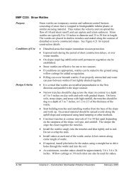
Figure 3.2<br />
Procedure for Determining Buffers for Aquatic Fish and Wildlife Habitat Conservation Areas<br />
Is the proposed development, removal of vegetation or other modification located in a stream, lake,<br />
pond designated as a FWHCA, or marine water Is it located within 200 feet of the bank full width of a<br />
stream as defined in WAC 222-16-010 Is it located within 200 feet of the ordinary high water mark<br />
(OHWM) of a lake or pond designated as a FWHCA Is it located within 200 feet of the OHWM of a<br />
marine shoreline<br />
If the response to any of the above questions is yes,<br />
determine whether a coastal geologic buffer is<br />
necessary. If proposed development involves building a<br />
structure within 200 feet of the OHWM of an erodible<br />
marine shoreline (any shoreline thatwhich is not<br />
bedrock), determine whether the site is a geologically<br />
hazardous area, or whether it may provide sediment to<br />
an area with eelgrass, shellfish, spawning or holding<br />
areas for forage fish, mudflats, or intertidal habitats with<br />
vascular plants. If the answer to either question is yes,<br />
qualified professional prepares geotechnical report and<br />
determines appropriate coastal geologic buffer to allow<br />
for natural erosive processes for life of the structure (75<br />
years). In all cases (yes or no response) continue with<br />
the buffer/ tree protection zoneTree Protection Zone<br />
sizing procedure.<br />
If the response to all of the above<br />
questions is no, no further action is<br />
necessary for compliance with<br />
FWHCA protection requirements for<br />
streams, lakes, ponds, and marine<br />
waters. Proceed to evaluate compliance<br />
with protection requirements for other<br />
types of FWHCAs.<br />
Determine the width of the water quality-sensitivity<br />
buffer using the procedures in SJCC 18.30.150<br />
(Wetlands) and Table 3.6 for 70% pollutant removal and<br />
either the normal development or green development<br />
option.<br />
For areas with trees (defined as woody vegetation<br />
exceeding a height of 20 feet), determine the width of<br />
the tree protection zoneTree Protection Zone.<br />
Compare the size of the water quality-sensitivity buffer<br />
to any applicable tree protection zoneTree Protection<br />
Zones and coastal geologic buffers. The required area<br />
that must be protected is the greater of the three<br />
components.<br />
Adjustments. Existing structures and impervious areas<br />
are excluded from the buffer and tree protection<br />
zoneTree Protection Zone. If desired, tree protection<br />
zoneTree Protection Zone may be averaged.<br />
N:\L<strong>AN</strong>D USE\LONG R<strong>AN</strong>GE PROJECTS\PCODES-11-0004 CAO FWHCAs\Docs from PC and CC\FWHCAOrdCC_<strong>2012</strong>-10-26.doc