
Create successful ePaper yourself
Turn your PDF publications into a flip-book with our unique Google optimized e-Paper software.
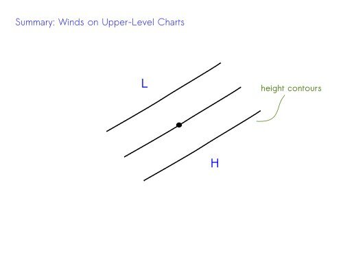
<str<strong>on</strong>g>Summary</str<strong>on</strong>g>: <str<strong>on</strong>g>Winds</str<strong>on</strong>g> <strong>on</strong> <strong>Upper</strong>-<strong>Level</strong> <strong>Charts</strong><br />
L<br />
height c<strong>on</strong>tours<br />
H
<str<strong>on</strong>g>Summary</str<strong>on</strong>g>: <str<strong>on</strong>g>Winds</str<strong>on</strong>g> <strong>on</strong> <strong>Upper</strong>-<strong>Level</strong> <strong>Charts</strong><br />
L<br />
PGF<br />
H<br />
PGF points from higher to<br />
lower heights
<str<strong>on</strong>g>Summary</str<strong>on</strong>g>: <str<strong>on</strong>g>Winds</str<strong>on</strong>g> <strong>on</strong> <strong>Upper</strong>-<strong>Level</strong> <strong>Charts</strong><br />
L<br />
PGF<br />
CF<br />
H<br />
Coriolis points opposite the<br />
PGF to balance (no fricti<strong>on</strong><br />
at upper levels)
<str<strong>on</strong>g>Summary</str<strong>on</strong>g>: <str<strong>on</strong>g>Winds</str<strong>on</strong>g> <strong>on</strong> <strong>Upper</strong>-<strong>Level</strong> <strong>Charts</strong><br />
L<br />
PGF<br />
wind<br />
CF<br />
H<br />
To be c<strong>on</strong>sistent, the wind points<br />
al<strong>on</strong>g the height c<strong>on</strong>tours!!
Which point has the bigger wind
Which point has the bigger wind<br />
PGF<br />
PGF<br />
The size of the PGF depends <strong>on</strong><br />
the c<strong>on</strong>tour spacing
Which point has the bigger wind<br />
PGF<br />
PGF<br />
CF<br />
CF<br />
A bigger PGF implies a bigger<br />
Coriolis force to balance
Which point has the bigger wind<br />
PGF<br />
wind<br />
PGF<br />
wind<br />
CF<br />
CF<br />
And a bigger Coriolis force<br />
implies a bigger wind
Which point has the bigger wind<br />
PGF<br />
wind<br />
PGF<br />
wind<br />
CF<br />
CF<br />
So tighter height c<strong>on</strong>tours mean bigger winds!!
This morning's (Fri) 300 mb chart, showing height c<strong>on</strong>tours, winds<br />
(arrows with feathers) and wind speeds (colors)
<str<strong>on</strong>g>Summary</str<strong>on</strong>g>: <str<strong>on</strong>g>Winds</str<strong>on</strong>g> <strong>on</strong> Surface Maps<br />
L<br />
PGF<br />
wind<br />
CF<br />
H<br />
Basically the same deal at the ground, but......
<str<strong>on</strong>g>Summary</str<strong>on</strong>g>: <str<strong>on</strong>g>Winds</str<strong>on</strong>g> <strong>on</strong> Surface Maps<br />
L<br />
PGF<br />
wind<br />
CF<br />
H<br />
Basically the same deal at the ground, but......because of fricti<strong>on</strong>,<br />
the winds cross the isobars towards lower pressure.
.....so maybe something like this<br />
L<br />
schematic winds <strong>on</strong> a surface map,<br />
c<strong>on</strong>verging towards low pressure
This morning's (Fri) surface map, showing isobars (c<strong>on</strong>tours) and<br />
winds (arrows with feathers)
Schematic showing winds in balance at upper levels (roughly),<br />
while......<br />
.....at the ground, winds are affected by fricti<strong>on</strong>.
Surface C<strong>on</strong>vergence and Rising Air<br />
Now, at the ground, the air crosses the isobars toward lower<br />
pressure. Which means.....<br />
●<br />
Around low pressure the air tends to c<strong>on</strong>verge into the center,<br />
while.....<br />
L
Surface C<strong>on</strong>vergence and Rising Air<br />
Now, at the ground, the air crosses the isobars toward lower<br />
pressure. Which means.....<br />
●<br />
Around low pressure the air tends to c<strong>on</strong>verge into the center,<br />
while.....<br />
●<br />
Around high pressure the air tends to diverge away from the<br />
center.
As air c<strong>on</strong>verges into a low center, it has to go somewhere.....so it<br />
rises. And as air diverges away from a high, it's replaced by air<br />
sinking from above. So the basic rule of thumb is<br />
low pressure center: air is rising<br />
high pressure center: air is sinking
As air c<strong>on</strong>verges into a low center, it has to go somewhere.....so it<br />
rises. And as air diverges away from a high, it's replaced by air<br />
sinking from above. So the basic rule of thumb is<br />
low pressure center: air is rising<br />
high pressure center: air is sinking<br />
And keep in mind that rising air tends to produce clouds and<br />
precipitati<strong>on</strong>, which brings us back to our original rule of<br />
thumb:<br />
Relatively speaking, cycl<strong>on</strong>es are areas with cloudy and<br />
rainy weather, while anticycl<strong>on</strong>es are typically clear and<br />
sunny!
Forecast for today (Fri) at no<strong>on</strong>, showing pressure (thin white<br />
c<strong>on</strong>tours) and predicted rain (green) and snow (blue and pink)