school of computing, informatics, and decision systems engineering
school of computing, informatics, and decision systems engineering
school of computing, informatics, and decision systems engineering

You also want an ePaper? Increase the reach of your titles
YUMPU automatically turns print PDFs into web optimized ePapers that Google loves.
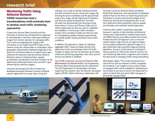
esearch brief<br />
Monitoring Traffic Using<br />
Airborne Sensors<br />
CIDSE researchers lead a<br />
transdisciplinary multi-university team<br />
to develop novel traffic monitoring<br />
approaches<br />
A team from Arizona State University <strong>and</strong> the<br />
University <strong>of</strong> Arizona has architectured an approach<br />
to automatically, in real-time, collect geo-reference<br />
images from remote cameras for managing traffic.<br />
This is done by integrating the imagery with<br />
information on the height <strong>and</strong> GPS location <strong>of</strong> the<br />
camera. Using this camera data, in combination with a<br />
geographic representation (latitude-longitude) <strong>of</strong> the<br />
area to be monitored, leads to an explicit way to georeference<br />
the observed road <strong>and</strong> vehicle locations.<br />
Absolute values <strong>of</strong> vehicle positions, speeds,<br />
accelerations, decelerations <strong>and</strong> lane changes can be<br />
determined. Initial experiments show promise in georeferencing<br />
the airborne imagery.<br />
Using this technology, the ASU-UA team has<br />
developed prototype s<strong>of</strong>tware to extract individual<br />
vehicle trajectories from aerial video. Using this<br />
s<strong>of</strong>tware, one is able to identify individual vehicles<br />
<strong>and</strong> their movement across consecutive images. By<br />
knowing the pixel coordinates <strong>and</strong> the approximate<br />
scale <strong>of</strong> the image, vehicle trajectories (in distance<br />
<strong>and</strong> time) can easily be determined. The ASU-<br />
UA team has demonstrated this technique using<br />
aerial videos in Tucson <strong>and</strong> Phoenix. Data sets <strong>of</strong><br />
vehicle trajectories can also be used for calibration<br />
<strong>and</strong> validation <strong>of</strong> microscopic traffic simulation<br />
models. Such simulation models can then be used<br />
for investigating possible roadway improvements<br />
or to better explain existing <strong>and</strong> likely future traffic<br />
conditions.<br />
In addition, this approach is viable for collecting<br />
aggregate traffic measures (delay, density, flow,<br />
speed, etc.) which are extremely useful for traffic<br />
mangers to figure out how the freeways <strong>and</strong> surface<br />
streets are performing, especially when other ground<br />
sensors are absent or disabled.<br />
The CIDSE researchers are led by Pr<strong>of</strong>essors Pitu<br />
Mirch<strong>and</strong>ani <strong>and</strong> Ronald Askin. Civil Engineering<br />
Pr<strong>of</strong>essor Mark Hickman leads the UA researchers.<br />
The U.S. Department <strong>of</strong> Transportation has been<br />
supporting the research. Also, the German Aerospace<br />
Agency (DLR) in Berlin, Germany, collaborates with<br />
the team. Led by Dr. Reinhart Kühne <strong>and</strong> Martin<br />
Ruhé, DLR researchers have developed an integrated<br />
platform that can be flown on fixed-wing planes <strong>and</strong><br />
helicopters to acquire <strong>and</strong> transmit images at five<br />
frames per second <strong>and</strong> subsequently, also in real<br />
time, determine traffic parameters such as speeds<br />
<strong>and</strong> densities, <strong>and</strong> individual vehicle trajectories.<br />
However, their system is expensive, especially<br />
because it requires a high-resolution pr<strong>of</strong>essional<br />
camera <strong>and</strong> a high-precision inertial measurement<br />
unit (IMU) that very accurately localizes the camera.<br />
Instead, the ASU-UA approach uses a consumer<br />
camera, albeit a high-end one, to capture images,<br />
but accurately localizes the captured images on a<br />
geo-referenced map using fast image processing<br />
algorithms. Success <strong>of</strong> this research could lead to<br />
having cameras on UAV’s that could be used for not<br />
only monitoring daily traffic congestion <strong>and</strong> incidents,<br />
but also assist in managing traffic during evacuations.<br />
Mirch<strong>and</strong>ani states, “This could revolutionize how<br />
well <strong>and</strong> how fast we respond to traffic congestion<br />
<strong>and</strong> incidents. I can imagine a future where a fleet<br />
<strong>of</strong> equipped UAVs will be available for dispatching to<br />
any location at any time, to assist first responders to<br />
get to incidents fast <strong>and</strong> assist traffic managers to<br />
proactively manage traffic.”<br />
14<br />
Pr<strong>of</strong>essor Pitu Mirch<strong>and</strong>ani (left)