Transmittal Letter, Cover, Table of Contents & Document
Transmittal Letter, Cover, Table of Contents & Document
Transmittal Letter, Cover, Table of Contents & Document

You also want an ePaper? Increase the reach of your titles
YUMPU automatically turns print PDFs into web optimized ePapers that Google loves.
Via Electronic Filing<br />
August 26, 2010<br />
Honorable Kimberly D. Bose, Secretary<br />
Federal Energy Regulatory Commission<br />
888 First Street, NE<br />
Washington, DC 20426<br />
Subject: Loup River Hydroelectric Project<br />
FERC Project No. 1256<br />
Initial Study Report<br />
Dear Secretary Bose:<br />
Loup River Public Power District (Loup Power District or District) herein electronically files its Initial Study<br />
Report (ISR) for relicensing the Loup River Hydroelectric Project, FERC Project No. 1256 (Project). The<br />
District is the owner, operator, and original licensee <strong>of</strong> the Project. The existing license was effective on<br />
December 1, 1982, for a term ending April 15, 2014. Loup Power District is utilizing the Integrated<br />
Licensing Process (ILP) for this relicensing effort. Therefore, pursuant to 18 CFR §5.15, the District is filing<br />
its ISR.<br />
Electronic copies <strong>of</strong> the ISR are available on the District’s relicensing website: www.loup.com/relicense, as<br />
well as on the Commission’s eLibrary. Notice <strong>of</strong> the availability <strong>of</strong> this document is being provided to all<br />
relicensing participants, including federal and state resource agencies, local governments, and Native<br />
American tribes. A distribution list <strong>of</strong> those parties is attached. Additionally, copies <strong>of</strong> the ISR will be<br />
available at the District’s <strong>of</strong>fice in Columbus, Nebraska.<br />
In accordance with 18 CFR §5.15, the District will present the Initial Study Results to FERC and other<br />
relicensing participants during the Initial Study Results Meeting to be held on September 9, 2010, at the New<br />
World Inn (265 33rd Street) in Columbus. Following the meeting, the District will prepare the Study Results<br />
Meeting Summary and file the summary with FERC on September 24, 2010.<br />
If you have any questions regarding the ISR or any information provided by the District, please contact me at<br />
(402) 564-3171 ext. 268.<br />
Respectfully submitted,<br />
Neal D. Suess<br />
President/CEO<br />
Loup Power District<br />
Attachments:<br />
Distribution List<br />
Initial Study Report
Distribution List<br />
Federal Government / Representatives<br />
Advisory Council on Historic Preservation<br />
Reid Nelson<br />
Attn: John Eddins<br />
Old Post Office Building<br />
1100 Pennsylvania Avenue NW, Suite 803<br />
Washington DC 20004<br />
jeddins@achp.gov<br />
Bureau <strong>of</strong> Land Management<br />
Don Simpson<br />
State Director<br />
PO Box 1828<br />
Cheyenne, WY 82003<br />
don_simpson@blm.gov<br />
Bureau <strong>of</strong> Reclamation<br />
Mike Ferguson<br />
Great Plains Regional Office<br />
P.O. Box 36900<br />
Billings, MT 59107‐6900<br />
mferguson@gp.usbr.gov<br />
Department <strong>of</strong> Interior<br />
Office <strong>of</strong> Environmental Policy and Compliance<br />
Robert F. Stewart<br />
Regional Environmental Officer<br />
Denver Federal Center<br />
P.O. Box 25007, D‐108<br />
Denver, CO 80225‐0007<br />
Robert_F_Stewart@ios.doi.gov<br />
Department <strong>of</strong> Interior<br />
Office <strong>of</strong> Environmental Affairs<br />
Attn: Shawn Alam<br />
Willie R. Taylor<br />
Director<br />
1849 C St. NW ROOM 2353<br />
Washington, DC 20240<br />
Willie_Taylor@ios.doi.gov<br />
Environmental Protection Agency<br />
Region 7<br />
Joe Cothern<br />
NEPA Team Leader<br />
901 N. 5th Street<br />
Kansas City, KS 66101<br />
cothern.joe@epa.gov<br />
Federal Emergency Management Agency<br />
Regional Office<br />
Ken Sessa<br />
Environmental and Historic Preservation<br />
9221 Ward Parkway, Suite 300<br />
Kansas City, MO 64114‐3372<br />
kenneth.sessa@dhs.gov<br />
Federal Energy Regulatory Commission<br />
Regional Office<br />
Peggy Harding<br />
Regional Engineer<br />
230 South Dearborn Street, Room 3130<br />
Chicago, IL 60604<br />
peggy.harding@ferc.gov<br />
Federal Energy Regulatory Commission<br />
Lee Emery<br />
Project Coordinator<br />
888 1st Street NE Room 61‐01<br />
Washington, DC 20426<br />
lee.emery@ferc.gov<br />
Federal Energy Regulatory Commission<br />
Janet Hutzel<br />
888 1st Street NE Room 61‐01<br />
Washington, DC 20426<br />
janet.hutzel@ferc.gov<br />
Federal Energy Regulatory Commission<br />
Isis Johnson<br />
888 1st Street NE Room 61‐01<br />
Washington, DC 20426<br />
isis.johnson@ferc.gov<br />
Federal Energy Regulatory Commission<br />
Paul Makowski<br />
888 1st Street NE Room 61‐01<br />
Washington, DC 20426<br />
paul.makowski@ferc.gov<br />
1 August 26, 2010
Distribution List<br />
Fish and Wildife Service<br />
Robert Harms<br />
Biologist<br />
Federal Building<br />
203 West Second Street<br />
Grand Island, NE 68801<br />
robert_harms@fws.gov<br />
Fish and Wildife Service<br />
Jeff Runge<br />
Biologist<br />
Federal Building<br />
203 West Second Street<br />
Grand Island, NE 68801<br />
jeff_runge@fws.gov<br />
National Marine Fisheries<br />
Prescott Brownell<br />
Regional FERC Coordinator<br />
219 Fort Johnson Rd<br />
Charleston, NC 29412<br />
prescott.brownell@noaa.gov<br />
National Park Service Field Office<br />
Randy Thoreson<br />
Midwest Region / Outdoor Recreation Planner<br />
111 E. Kellog Blvd, Suite 105<br />
St. Paul, MN 55101<br />
randy_thoreson@nps.gov<br />
U.S. Army Corps <strong>of</strong> Engineers<br />
Barb Friskopp<br />
1430 Central Avenue<br />
Kearney, NE 68847<br />
barbara.j.friskopp@usace.army.mil<br />
U.S. House <strong>of</strong> Representatives<br />
Jeff Fortenberry<br />
First District, Nebraska<br />
c/o Louis P<strong>of</strong>ahl<br />
P.O. Box 377<br />
629 Broad Street<br />
Fremont, NE 68026<br />
louis‐p<strong>of</strong>ahl@mail.house.gov<br />
U.S. House <strong>of</strong> Representatives<br />
Adrian Smith<br />
Third District, Nebraska<br />
c/o Todd Crawford/ Deb VanMatre<br />
1811 West Second Street<br />
Suite 105<br />
Grand Island, NE 68803<br />
todd.crawford@mail.house.gov<br />
deb.vanmatre@mail.house.gov<br />
U.S. Senate<br />
Mike Johanns<br />
c/o Emily Brummond<br />
4111 Fourth Ave<br />
Suite 26<br />
Kearney, NE 68845<br />
emily_brummund@johanns.senate.gov<br />
U.S. Senate<br />
Ben Nelson<br />
c/o Zach Nelson<br />
PO Box 791<br />
South Sioux City, NE 68776<br />
zach_nelson@bennelson.senate.gov<br />
U.S. Geological Survey<br />
Jason Alexander, Hydrologist<br />
5231 South 19th<br />
Lincoln, NE 68512<br />
jalexand@usgs.gov<br />
State Government<br />
Conservation and Survey Division Geological<br />
Survey<br />
Mark Kuzila, Director<br />
Hardin Hall, 3310 Holdrege Street<br />
University <strong>of</strong> Nebraska‐Lincoln<br />
Lincoln, NE 68583<br />
mkuzila1@unl.edu<br />
Natural Resources Conservation Service<br />
Steve Chick<br />
State Conservationist<br />
Federal Building, Room 152<br />
100 Centennial Mall North<br />
Lincoln, NE 68508<br />
steve.chick@ne.usda.gov<br />
2 August 26, 2010
Distribution List<br />
Nebraska Attorney General’s Office<br />
Agriculture, Environmental and Natural Resources<br />
Justin Lavene<br />
Special Counsel to the Attorney General<br />
2115 State Capitol Drive<br />
Lincoln, NE 68509<br />
justin.lavene@nebraska.gov<br />
Nebraska Department <strong>of</strong> Agriculture<br />
Bobbie Kriz‐Wickman<br />
Public/Government Relations<br />
301 Centennial Mall South<br />
PO Box 94947<br />
Lincoln, NE 68509<br />
bobbie.wickham@nebraska.gov<br />
Nebraska Department <strong>of</strong> Environmental<br />
Quality<br />
John Bender<br />
Water Quality Standards Coordinator<br />
PO Box 98922<br />
Lincoln, NE 68509<br />
john.bender@nebraska.gov<br />
Nebraska Department <strong>of</strong> Health and Human<br />
Services<br />
Northeast Regional Office<br />
David Jundt<br />
Water Supply Specialist<br />
304 North 5th St. Suite C<br />
Norfolk, NE 68701<br />
david.jundt@nebraska.gov<br />
Nebraska Department <strong>of</strong> Natural Resources<br />
Brian Dunnigan<br />
Director<br />
State Office Building, 4th Floor<br />
300 Centennial Mall South; P.O. Box 4676<br />
Lincoln, NE 68509<br />
Brian.dunnigan@nebraska.gov<br />
Nebraska Emergency Management Agency<br />
Al Berndt<br />
1300 Military Road<br />
Lincoln, NE 68508<br />
al.berndt@nebraska.gov<br />
Nebraska Game and Parks Commission<br />
Frank Albrecht<br />
Assistant Director <strong>of</strong> Administration<br />
2200 N. 33rd<br />
Lincoln, NE 68503<br />
frank.albrecht@nebraska.gov<br />
Nebraska State Historical Preservation Office<br />
Robert Puschendorf<br />
Deputy State Historical Preservation Officer<br />
1500 R Street<br />
P.O. Box 82554<br />
Lincoln, NE 68501<br />
bob.puschendorf@nebraska.gov<br />
Nebraska State Historical Preservation Office<br />
Jill Dolberg<br />
Review and Compliance Coordinator<br />
1500 R Street<br />
P.O. Box 82554<br />
Lincoln, NE 68501<br />
jill.dolberg@nebraska.gov<br />
Nebraska Unicameral<br />
District #34<br />
Annette Dubas<br />
54906 N. 180th Ave<br />
Fullerton, NE 68634<br />
adubas@leg.ne.gov<br />
Nebraska Unicameral<br />
District #23<br />
Chris Langemeier<br />
P.O. Box 192<br />
Schuyler, NE 68661<br />
clangemeier@leg.ne.gov<br />
Nebraska Unicameral<br />
District #41<br />
Kate Sullivan<br />
Room 1019 ‐ State Capitol<br />
P.O. Box 94604<br />
Lincoln, NE 68509<br />
ksullivan@leg.ne.gov<br />
Nebraska Unicameral<br />
District #22<br />
Arnie Stuthman<br />
24160 310th Street<br />
Platte Center, NE 68653<br />
astuthman@leg.ne.gov<br />
3 August 26, 2010
Distribution List<br />
Local Government<br />
City <strong>of</strong> Columbus<br />
Joseph Mangiamelli<br />
Administrator<br />
City Hall ~ First Floor 2424 14th Street<br />
P.O. Box 1677<br />
Columbus, NE 68602<br />
jmangi@columbusne.us<br />
City <strong>of</strong> Fullerton<br />
James Kramer<br />
City Administrator<br />
903 Broadway Street<br />
PO Box 670<br />
Fullerton, NE 68638<br />
cityadmin@cablene.com<br />
City <strong>of</strong> Genoa<br />
Lacie Andreasen<br />
City Administrator / Clerk<br />
P.O. Box 279<br />
Genoa, NE 68640<br />
cgenoa@cablene.com<br />
Nance County<br />
Board <strong>of</strong> Supervisors<br />
Dennis Jarecke<br />
Chairman<br />
53836 S. 320th Ave.<br />
Fullerton, NE 68638<br />
djjarecke@clarkswb.net<br />
Nance County<br />
Planning and Zoning Commission<br />
Mary Los<br />
PO Box 821<br />
Fullerton, NE 68638<br />
ncpza@hamilton.net<br />
Platte County<br />
Board <strong>of</strong> Supervisors<br />
Bob Lloyd<br />
President<br />
2610 14th Street<br />
Columbus, NE 68601<br />
pcclerk@megavision.com<br />
City <strong>of</strong> Monroe<br />
Connie Kramer, City Clerk<br />
122 Gerrard Avenue<br />
P.O. Box 103<br />
Monroe, NE 68647<br />
monroe@megavision.com<br />
Public Agency<br />
Central Platte Natural Resource District<br />
Ron Bishop<br />
General Manager<br />
215 N Kaufman Avenue<br />
Grand Island, NE 68803<br />
rbishop@cpnrd.org<br />
Lower Loup Natural Resource District<br />
Leon Koehlmoos<br />
Manager<br />
2620 Airport Dr<br />
P.O. Box 210<br />
Ord, NE 68862<br />
butchk@nctc.net<br />
Lower Loup Natural Resource District<br />
Robert Mohler<br />
District Engineer<br />
2620 Airport Dr<br />
P.O. Box 210<br />
Ord, NE 68862<br />
robertm@llnrd.org<br />
Lower Platte North Natural Resource District<br />
John Miyoshi<br />
Manager<br />
511 Commercial Park<br />
P.O. Box 126<br />
Wahoo, NE 68066<br />
jmiyoshi@lpnnrd.org<br />
4 August 26, 2010
Distribution List<br />
Lower Platte South Natural Resource District<br />
Glenn Johnson<br />
General Manager<br />
3125 Portia Street<br />
PO Box 83581<br />
Lincoln, NE 68501<br />
lpsnrd@lpsnrd.org<br />
Papio‐Missouri Natural Resource District<br />
John Winkler<br />
General Manager<br />
8901 S. 154th St.<br />
Omaha, NE 68138<br />
jwinkler@papionrd.org<br />
Upper Loup Natural Resource District<br />
Anna Baum<br />
General Manager<br />
39252 Highway 2<br />
Thedford, NE 69166<br />
abaum@upperloupnrd.org<br />
Nebraska Public Power District<br />
John Shadle<br />
Water Resource Advisor<br />
1414 15th Street<br />
PO Box 499<br />
Columbus, NE 68602<br />
jjshadl@nppd.com<br />
Nebraska Public Power District<br />
Jon Sunneberg<br />
NPPD Resource Planning and Risk Manager<br />
1414 15th Street<br />
PO Box 499<br />
Columbus, NE 68602<br />
jmsunne@nppd.com<br />
Lower Platte River Corridor Alliance<br />
Meghan Sittler<br />
Coordinator<br />
3125 Portia Street<br />
P.O. Box 83581<br />
Lincoln, NE 68501<br />
msittler@lpsnrd.org<br />
Platte River Recovery Implementation Program<br />
Jerry Kenny<br />
Executive Director<br />
3710 Central Avenue, Suite E<br />
Kearney, NE 68847<br />
kennyj@headwaterscorp.com<br />
Native American Tribes<br />
Bureau <strong>of</strong> Indian Affairs,<br />
Great Plains Regional Office<br />
Michael Black<br />
115 4th Avenue SE<br />
Aberdeen, SD 57401<br />
Mike.black@bia.gov<br />
Omaha Tribe <strong>of</strong> Nebraska<br />
Amen Sheridan<br />
Chairman<br />
PO Box 368<br />
Macy, NE 68039<br />
asheridan@omahatribe.com<br />
Pawnee Tribal Business Council<br />
George Howell<br />
President<br />
P.O. Box 470<br />
Pawnee, OK 74058<br />
vwills@pawneenation.org<br />
Ponca Tribe <strong>of</strong> Nebraska<br />
Larry Wright, Jr.<br />
Chairperson<br />
607 Georgia Ave<br />
Norfolk, NE 68701<br />
lewrightjr@gmail.com<br />
5 August 26, 2010
Distribution List<br />
Ponca Tribe <strong>of</strong> Oklahoma<br />
Douglas Rhodd<br />
Chairman<br />
20 White Eagle Drive<br />
Ponca City, OK 74601<br />
chairmanrhodd@ponca.com<br />
Santee Sioux Tribal Council<br />
Roger Trudell<br />
Chairman<br />
425 Frazier Avenue N, Suite 2<br />
Niobrara, NE 68760<br />
rtrudell@santeedakota.org<br />
Winnebago Tribal Council<br />
John Blackhawk<br />
Chairman<br />
PO Box 687<br />
100 Bluff Street<br />
Winnebago, NE 68071<br />
jblackhawk@aol.com<br />
Non‐Governmental Organizations<br />
Columbus Area Recreation and Trails (C.A.R.T.)<br />
Marv Peterson<br />
President<br />
2717 33rd Street<br />
Columbus, NE 68601<br />
Marvp@megavision.com<br />
Columbus Area Recreation and Trails (C.A.R.T.)<br />
Curt Alms<br />
Treasurer<br />
2717 33rd Street<br />
P.O. Box 515<br />
Columbus, NE 68601<br />
calms@neb.rr.com<br />
NOHVA<br />
Dan Nitzel<br />
2231 W 10th Street<br />
Grand Island, NE 68831<br />
danno@nohva.com<br />
Tern and Plover Conservation Partnership<br />
Mary Bomberger‐Brown<br />
Program Coordinator<br />
3310 Holdrege Street<br />
153 Hardin Hall<br />
Lincoln, NE 68583<br />
mbrown9@unl.edu<br />
6 August 26, 2010
Initial Study Report
Loup River Hydroelectric Project<br />
FERC Project No. 1256<br />
Initial Study Report<br />
August 26, 2010<br />
© 2010 Loup River Public Power District<br />
Prepared by:<br />
With assistance by:<br />
Loup Power District<br />
HDR Engineering, Inc.<br />
2404 15 th Street 8404 Indian Hills Drive<br />
Columbus, NE 68602 Omaha, NE 68114
<strong>Table</strong> <strong>of</strong> <strong>Contents</strong><br />
INTRODUCTION ........................................................................................................................ 1<br />
A. PROJECT BACKGROUND ........................................................................................... 1<br />
B. PROCESS TO DATE .................................................................................................... 1<br />
C. 2010 PRECIPITATION AND RESULTING FLOW CONDITIONS ................................. 4<br />
D. STATUS OF STUDIES ................................................................................................. 6<br />
SECTION 1 STUDY 1.0, SEDIMENTATION ...................................................................... 1-1<br />
SECTION 2 STUDY 2.0, HYDROCYCLING ....................................................................... 2-1<br />
SECTION 3 STUDY 3.0, WATER TEMPERATURE IN THE PLATTE RIVER ................... 3-1<br />
SECTION 4<br />
STUDY 4.0, WATER TEMPERATURE IN THE LOUP RIVER<br />
BYPASS REACH ........................................................................................... 4-1<br />
SECTION 5 STUDY 5.0, FLOW DEPLETION AND FLOW DIVERSION ........................... 5-1<br />
SECTION 6 STUDY 6.0, FISH SAMPLING ........................................................................ 6-1<br />
SECTION 7 STUDY 7.0, FISH PASSAGE ......................................................................... 7-1<br />
SECTION 8 STUDY 8.0, RECREATION USE .................................................................... 8-1<br />
SECTION 9 STUDY 9.0, CREEL SURVEY ........................................................................ 9-1<br />
SECTION 10 STUDY 10.0, LAND USE INVENTORY ........................................................ 10-1<br />
SECTION 11 STUDY 11.0, SECTION 106 COMPLIANCE ................................................ 11-1<br />
SECTION 12 STUDY 12.0, ICE JAM FLOODING ON THE LOUP RIVER ........................ 12-1<br />
SECTION 13 PCB FISH TISSUE SAMPLING ................................................................... 13-1<br />
SECTION 14 REFERENCES ............................................................................................. 14-1<br />
LIST OF APPENDICES<br />
APPENDIX A<br />
APPENDIX B<br />
APPENDIX C<br />
APPENDIX D<br />
APPENDIXE<br />
APPENDIX F<br />
APPENDIX G<br />
APPENDIX H<br />
APPENDIX I<br />
SEDIMENTATION STUDY REPORT<br />
HYDROCYCLING STUDY REPORT<br />
WATER TEMPERATURE IN THE LOUP RIVER BYPASS REACH STUDY<br />
REPORT<br />
FLOW DEPLETION/FLOW DIVERSION STUDY REPORT<br />
FISH PASSAGE STUDY REPORT<br />
RECREATION USE STUDY REPORT<br />
LAND USE INVENTORY STUDY REPORT<br />
SECTION 106 COMPLIANCE STUDY REPORT<br />
ICE JAM FLOODING ON THE LOUP RIVER STUDY REPORT<br />
© 2010 Loup River Public Power District i Initial Study Report<br />
FERC Project No. 1256 August 2010
Introduction<br />
INTRODUCTION<br />
Loup River Public Power District (Loup Power District or the District) has prepared<br />
this Initial Study Report (ISR) for filing with the Federal Energy Regulatory<br />
Commission (FERC) as part <strong>of</strong> relicensing the Loup River Hydroelectric Project<br />
(FERC Project No. 1256) and in accordance with the regulations <strong>of</strong> FERC’s<br />
Integrated Licensing Process (ILP) (18 Code <strong>of</strong> Federal Regulations [CFR] 5).<br />
As described in the District’s Process Plan and Schedule, which was included in the<br />
District’s Pre-Application <strong>Document</strong> (PAD) and approved by FERC, this ISR is being<br />
filed electronically with FERC and appropriate agencies and stakeholders. In<br />
addition, agencies and stakeholders known to have an interest in the proceeding have<br />
been notified via email <strong>of</strong> the availability <strong>of</strong> the ISR on the District’s relicensing<br />
website at http://www.loup.com/relicense.<br />
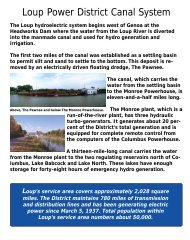
A. PROJECT BACKGROUND<br />
The Loup River Hydroelectric Project (Project) is located in Nance and Platte<br />
counties, Nebraska, where water is diverted from the Loup River and routed through<br />
the 35-mile-long Loup Power Canal, which empties into the Platte River near<br />
Columbus. The Project includes various hydraulic structures, two powerhouses, and<br />
two regulating reservoirs, as shown in Figure 1. The current license for the Project<br />
expires on April 15, 2014. Therefore, the District is seeking a new license to continue<br />
to operate the Project.<br />
B. PROCESS TO DATE<br />
The District has achieved several major milestones in association with Project<br />
relicensing. In addition to these milestones, listed below, the District has solicited<br />
extensive public and agency input throughout the relicensing process:<br />
Notice <strong>of</strong> Intent and Pre-Application <strong>Document</strong> – The District initiated<br />
Project relicensing when the Notice <strong>of</strong> Intent (NOI) and PAD were filed<br />
with FERC on October 16, 2008. Collectively, the NOI and PAD stated the<br />
District’s intentions to renew its existing operating license and provided<br />
known information relative to Project history, operations, maintenance, and<br />
facilities, as well as existing natural and human environments within the<br />
Project Boundary. Lastly, the PAD introduced initial issues, concerns, and<br />
questions potentially related to operation <strong>of</strong> the Project that were identified<br />
during agency and workgroup meetings and identified potential studies to<br />
address these issues.<br />
© 2010 Loup River Public Power District 1 Initial Study Report<br />
FERC Project No. 1256 August 2010
R-4-W<br />
R-3-W<br />
R-2-W<br />
R-1-W<br />
R-1-E<br />
R-2-E<br />
Lake North<br />
Monroe Powerhouse<br />
Lower Power Canal<br />
Lake Babcock<br />
Intake Canal<br />
Upper Power Canal<br />
T-18-N<br />
Monroe<br />
Columbus Powerhouse<br />
Z:\Projects\Loup_Power_District\37104_LPD_FERC_Relicensing\map_docs\mxd\Project_Location_Study_Plan_Fig_1.mxd\july09\jcm<br />
Settling Basin<br />
Headworks<br />
Project<br />
Location<br />
Genoa<br />
Nance & Platte Counties, Nebraska<br />
Loup River<br />
Nance<br />
County<br />
Platte<br />
County<br />
Merrick<br />
County<br />
2 1 0 2<br />
Miles<br />
Aerial Imagery: 2006 National Agricultural Inventory Project, Nance and Platte Counties Mosaic.<br />
Streams/Lakes: 2000 Tiger Line Files, Platte and Nance Counties.<br />
Legend<br />
Loup Power Canal<br />
Corporate Limits<br />
Township/Range<br />
County Line<br />
Loup River<br />
Platte River<br />
Project Location<br />
Polk<br />
County<br />
Loup River Hydroelectric Project<br />
FERC Project No. 1256<br />
Initial Study Report<br />
Columbus<br />
Butler<br />
County<br />
© 2010 Loup River Public Power District<br />
Tailrace Canal<br />
Platte River<br />
DATE<br />
FIGURE<br />
August 2010<br />
1<br />
T-17-N<br />
T-16-N
Introduction<br />
Scoping <strong>Document</strong> 1 – FERC issued Scoping <strong>Document</strong> 1 (SD1) on<br />
December 12, 2008. The purpose <strong>of</strong> SD1 was to provide information on<br />
the Project and to solicit comments and suggestions on the preliminary list<br />
<strong>of</strong> issues and alternatives to be addressed in FERC’s Environmental<br />
Assessment (EA).<br />
Proposed Study Plan – The District’s Proposed Study Plan (PSP) was<br />
prepared in accordance with 18 CFR 5.11 and was filed on March 27, 2009.<br />
The PSP detailed 12 studies proposed by the District and agencies.<br />
Additionally, the document discussed the District’s position on why<br />
additional studies are not warranted.<br />
Scoping <strong>Document</strong> 2 – Also on March 27, 2009, FERC issued Scoping<br />
<strong>Document</strong> 2 (SD2) based on the verbal comments received at the scoping<br />
meetings and written comments received throughout the scoping process.<br />
The purpose <strong>of</strong> SD2 was to clarify issues identified in SD1 based on<br />
information received during the scoping process, to advise all participants<br />
about additional issues identified for inclusion in the proposed scope <strong>of</strong> the<br />
EA, and to seek additional information pertinent to these analyses.<br />
Revised Study Plan – The District’s Revised Study Plan (RSP) was<br />
prepared in accordance with 18 CFR 5.13 and was filed on July 27, 2009.<br />
The RSP addressed all comments received on the PSP and included<br />
updated plans for the 12 studies included in the PSP (these studies are listed<br />
in Section D, below). Three studies from the PSP were eliminated in the<br />
RSP based on discussions at the study plan meetings, conducted in<br />
accordance with 18 CFR 5.11(e): Water Temperature in the Platte River,<br />
Fish Sampling, and Creel Survey.<br />
Study Plan Determination – FERC issued its Study Plan Determination on<br />
August 26, 2009, in accordance with 18 CFR 5.13(c). In its Study Plan<br />
Determination, FERC: 1) approved three studies as defined in the RSP<br />
without modification (Fish Passage, Land Use Inventory, and Section 106<br />
Compliance); 2) approved six studies as defined in the RSP with<br />
modification (Sedimentation, Hydrocycling, Water Temperature in the<br />
Loup River Bypass Reach, Flow Depletion and Flow Diversion, Recreation<br />
Use, and Ice Jam Flooding on the Loup River); and 3) removed three<br />
studies consistent with recommendations made in the RSP (Water<br />
Temperature in the Platte River, Fish Sampling, and Creel Survey<br />
[combined with Recreation Use]).<br />
The modifications recommended by FERC in its Study Plan Determination, which<br />
were specific to the six studies listed in the preceding bullet, were adopted by the<br />
District and incorporated into the data collection and analysis that has occurred since<br />
issuance <strong>of</strong> the Study Plan Determination. Additionally, the District submitted<br />
© 2010 Loup River Public Power District 3 Initial Study Report<br />
FERC Project No. 1256 August 2010
Introduction<br />
Quarterly Progress Reports, which documented study progress in accordance with<br />
18 CFR 5.15(b), on December 1, 2009, February 24, 2010, and May 24, 2010.<br />
C. 2010 PRECIPITATION AND RESULTING FLOW CONDITIONS<br />
During the spring <strong>of</strong> 2010, the majority <strong>of</strong> Nebraska’s 93 counties, including areas<br />
within the Loup and Platte River basins, were subjected to heavy precipitation and<br />
flooding; these counties, including Nance and Platte counties, have been declared<br />
disaster areas by the governor and are expected to apply for federal disaster<br />
assistance. In Columbus, the total precipitation for June alone was 12.29 inches.<br />
This equates to the second wettest June on record (1893-2010) and the wettest June<br />
since 1967, when 12.49 inches were documented (High Plains Regional Climate<br />
Center, June 30, 2010). As recorded by the U.S. Geological Survey (USGS) and<br />
depicted in Figures 2 and 3, the heavy 2010 precipitation resulted in Loup and Platte<br />
river discharges well above mean values for the months <strong>of</strong> May through July.<br />
Although the Project area was not subjected to the widespread flooding that occurred<br />
throughout much <strong>of</strong> the state, associated high flows combined with high winds in May<br />
resulted in difficult topographic and hydraulic survey conditions along the Loup and<br />
Platte rivers, as required by multiple studies being conducted during the relicensing<br />
process. Specific ramifications on the topographic and hydraulic surveys and<br />
associated studies are as follows:<br />
Sedimentation Study – Cross section information from three ungaged sites<br />
along the Loup and Lower Platte rivers was not obtained in time to<br />
complete the necessary hydraulic analysis prior to submittal <strong>of</strong> this Initial<br />
Study Report (see Section 1 and Appendix A).<br />
Hydrocycling and Flow Depletion and Flow Diversion Studies – Cross<br />
section information from three Lower Platte River study sites, which is<br />
necessary to facilitate a HEC-RAS 1D steady state back-water model, was<br />
unobtainable during the first week <strong>of</strong> May (as specified in FERC’s Study<br />
Plan Determination) due to widespread sandbar inundation and high winds<br />
(see Sections 2 and 5).<br />
Due to continued high flows and the observation <strong>of</strong> nesting interior least terns within<br />
the study reach, the cross section information that was to be collected during the first<br />
week in August for the Hydrocycling and Flow Depletion and Flow Diversion studies<br />
was also delayed (see Sections 2 and 5). In addition, high flows have delayed the<br />
collection <strong>of</strong> water temperature data that was to occur in August for the Water<br />
Temperature in the Loup River Bypass Reach study (see Section 4). Water<br />
temperature data for this study will be collected when near normal flows return in the<br />
Loup and Lower Platte rivers.<br />
© 2010 Loup River Public Power District 4 Initial Study Report<br />
FERC Project No. 1256 August 2010
Introduction<br />
Figure 2. Discharge recorded by USGS Gage 06793000, Loup<br />
River near Genoa, NE, during May, June, and July 2010<br />
Figure 3. Discharge recorded by USGS Gage 06796000, Platte<br />
River at North Bend, NE, during May, June, and July 2010<br />
© 2010 Loup River Public Power District 5 Initial Study Report<br />
FERC Project No. 1256 August 2010
Introduction<br />
D. STATUS OF STUDIES<br />
The status <strong>of</strong> each FERC-approved study plan is summarized below. More detailed<br />
discussions <strong>of</strong> the studies are provided in subsequent sections <strong>of</strong> this Initial Study<br />
Report and in the appendices, where study reports are provided for those studies for<br />
which data collection and analysis are substantially complete.<br />
Study 1.0, Sedimentation – The sedimentation study is substantially<br />
complete with the exception <strong>of</strong> the analysis <strong>of</strong> the ungaged study sites,<br />
as discussed in Section C, above. The results <strong>of</strong> the ungaged study site<br />
analysis will be presented in the updated Initial Study Report on January 6,<br />
2011. A summary <strong>of</strong> the goals and objectives, study area, methods, and<br />
results to date is provided in Section 1 and the completed Study Report is<br />
included as Appendix A.<br />
Study 2.0, Hydrocycling – Data collection and analysis for the<br />
hydrocycling study are ongoing. A summary <strong>of</strong> the goals and objectives,<br />
study area, methods, and progress to date is provided in Section 2. The<br />
study report will be provided to FERC in the updated Initial Study Report<br />
on January 6, 2011.<br />
Study 3.0, Water Temperature in the Platte River – The water temperature<br />
in the Platte River study was determined unnecessary for relicensing<br />
purposes in FERC’s Study Plan Determination.<br />
Study 4.0, Water Temperature in the Loup River Bypass Reach – Data<br />
collection and analysis for the water temperature in the Loup River bypass<br />
reach are ongoing. A summary <strong>of</strong> the goals and objectives, study area,<br />
methods, and progress to date is provided in Section 4. The study report<br />
will be provided to FERC in the updated Initial Study Report on January 6,<br />
2011.<br />
Study 5.0, Flow Depletion and Flow Diversion – Data collection and<br />
analysis for the flow depletion and flow diversion study are ongoing. A<br />
summary <strong>of</strong> the goals and objectives, study area, methods, and progress to<br />
date is provided in Section 5. The study report will be provided to FERC in<br />
the updated Initial Study Report on January 6, 2011.<br />
Study 6.0, Fish Sampling – The fish sampling study was determined<br />
unnecessary for relicensing purposes in FERC’s Study Plan Determination.<br />
Study 7.0, Fish Passage – The fish passage study is complete. A summary<br />
<strong>of</strong> the goals and objectives, study area, methods, and results is provided in<br />
Section 7. The completed study report is included as Appendix E.<br />
Study 8.0, Recreation Use – Data collection and analysis for the recreation<br />
use study are ongoing. A summary <strong>of</strong> the goals and objectives, study area,<br />
methods, and progress to date is provided in Section 8. Additionally, an<br />
© 2010 Loup River Public Power District 6 Initial Study Report<br />
FERC Project No. 1256 August 2010
Introduction<br />
executive summary report <strong>of</strong> the results <strong>of</strong> a telephone survey conducted for<br />
this study is included as Appendix F. The study report will be provided to<br />
FERC in the updated Initial Study Report on January 6, 2011, and the<br />
resulting Recreation Management Plan will be included with the District’s<br />
license application.<br />
Study 9.0, Creel Survey – The creel survey was combined with Study 8.0,<br />
Recreation Use (see above), consistent with the RSP, agency input, and<br />
FERC’s Study Plan Determination.<br />
Study 10.0, Land Use Inventory – The land use inventory is complete. A<br />
summary <strong>of</strong> the goals and objectives, study area, methods, and results is<br />
provided in Section 10. The completed study report is included as<br />
Appendix G.<br />
Study 11.0, Section 106 Compliance – The following components <strong>of</strong> the<br />
Section 106 compliance study are complete and have been submitted to the<br />
Nebraska State Historic Preservation Office (Nebraska SHPO) and/or<br />
Native American tribes for review: Phase IA Archaeological Overview,<br />
Phase I/II Archaeological Inventory and Evaluation, and Historic Building<br />
Inventory and Evaluation. The Ethnographic <strong>Document</strong>ation will be<br />
completed and submitted after review <strong>of</strong> the archaeological reports by<br />
Native American tribes. The Historic Properties Management Plan and<br />
Executed Programmatic Agreement will be developed in consultation with<br />
FERC and Nebraska SHPO upon approval <strong>of</strong> the other Section 106<br />
compliance study reports. An overall study summary <strong>of</strong> the goals and<br />
objectives, study area, methods, and results is provided in Section 11.<br />
Study 12.0, Ice Jam Flooding on the Loup River – Data collection and<br />
analysis for the ice jam flooding on the Loup River study are ongoing. A<br />
summary <strong>of</strong> the goals and objectives, study area, methods, and progress to<br />
date is provided in Section 12. The study report will be provided to FERC<br />
in the updated Initial Study Report on January 6, 2011.<br />
PCB Fish Tissue Sampling – Although PCB fish tissue sampling is not a<br />
formal study, the Nebraska Department <strong>of</strong> Environmental Quality (NDEQ)<br />
completed fish tissue sampling in 2009, and the U.S. Environmental<br />
Protection Agency, Region 7 completed analysis <strong>of</strong> those samples in 2010,<br />
as required by FERC’s Study Plan Determination. A summary <strong>of</strong> the goals<br />
and objectives, study area, methods, and results is provided in Section 13.<br />
A report that summarizes these activities and the resulting analytical results<br />
is included as Appendix J.<br />
The District will present the Initial Study Results to FERC and other relicensing<br />
participants during the Initial Study Results Meeting to be held on September 9, 2010,<br />
at the New World Inn (265 33 rd Street) in Columbus. Following the meeting, the<br />
© 2010 Loup River Public Power District 7 Initial Study Report<br />
FERC Project No. 1256 August 2010
Introduction<br />
District will prepare the Study Results Meeting Summary. The meeting summary will<br />
be filed with FERC on September 24, 2010, and will include any study modifications<br />
or new study plans proposed by the District as a result <strong>of</strong> the Initial Study Results<br />
Meeting. Relicensing participants will have 30 days from submittal <strong>of</strong> the Study<br />
Results Meeting Summary to file a disagreement or propose study modifications or<br />
new studies.<br />
The District will submit an updated Initial Study Report to FERC on January 6, 2011,<br />
for the studies that are ongoing at the submittal <strong>of</strong> this Initial Study Report. The<br />
submittal <strong>of</strong> the updated Initial Study Report will be followed by an Initial Study<br />
Results Meeting to be held on January 20, 2011, at a location to be determined.<br />
© 2010 Loup River Public Power District 8 Initial Study Report<br />
FERC Project No. 1256 August 2010
Study 1.0 – Sedimentation<br />
SECTION 1<br />
STUDY 1.0, SEDIMENTATION<br />
1.1 GOALS AND OBJECTIVES OF STUDY<br />
The goal <strong>of</strong> the sedimentation study is to determine the effect, if any, that Project<br />
operations have on stream morphology and sediment transport in the Loup River<br />
bypass reach and in the lower Platte River 1 because stream morphology relates<br />
directly to habitat, and habitat may determine species abundance and success. In<br />
addition, the study will compare the availability <strong>of</strong> sandbar nesting habitat for interior<br />
least terns and piping plovers to their respective populations and will compare the<br />
general habitat characteristics <strong>of</strong> the pallid sturgeon in multiple locations.<br />
The objectives <strong>of</strong> the sedimentation study are as follows:<br />
1. To characterize sediment transport in the Loup River bypass reach and in<br />
the lower Platte River through effective discharge and other sediment<br />
transport calculations.<br />
2. To characterize stream morphology in the Loup River bypass reach and in<br />
the lower Platte River by reviewing existing data and literature on channel<br />
aggradation/degradation and cross sectional changes over time.<br />
3. To determine if a relationship can be detected between sediment transport<br />
parameters and interior least tern and piping plover nest counts (as provided<br />
by the Nebraska Game and Parks Commission [NGPC]) and productivity<br />
measures.<br />
4. To determine if sediment transport is a limiting factor for pallid sturgeon<br />
habitat in the lower Platte River below the Elkhorn River.<br />
1.2 STUDY AREA<br />
The study area includes the Loup River from approximately 5 miles upstream <strong>of</strong> the<br />
Diversion Weir, the Loup River bypass reach, and the lower Platte River. Specific<br />
study sites were selected based on the availability <strong>of</strong> gaged flow data from the USGS<br />
and Nebraska Department <strong>of</strong> Natural Resources (NDNR). The following gage<br />
stations were used as study sites:<br />
USGS Gage 06793000, Loup River near Genoa, NE<br />
USGS Gage 06794500, Loup River at Columbus, NE<br />
USGS Gage 06774000, Platte River near Duncan, NE<br />
USGS Gage 06796000, Platte River at North Bend, NE<br />
1<br />
The lower Platte River is defined as the reach between the confluence <strong>of</strong> the Loup and Platte<br />
rivers and the confluence <strong>of</strong> the Platte and Missouri rivers.<br />
© 2010 Loup River Public Power District 1-1 Initial Study Report<br />
FERC Project No. 1256 August 2010
Study 1.0 – Sedimentation<br />
USGS Gage 06796500, Platte River at Leshara, NE<br />
USGS Gage 06801000, Platte River near Ashland, NE<br />
USGS Gage 06805500, Platte River at Louisville, NE<br />
In addition to these study sites, three “ungaged” sites will also be evaluated:<br />
Loup River upstream <strong>of</strong> the Diversion Weir<br />
Lower Platte River downstream <strong>of</strong> the Loup River confluence and upstream<br />
<strong>of</strong> the Tailrace return confluence<br />
Lower Platte River within 5 miles downstream <strong>of</strong> the Tailrace return<br />
confluence<br />
The Loup River site was identified in the Revised Study Plan, and the lower Platte<br />
River sites were added by FERC in the Study Plan Determination dated August 26,<br />
2009. Due to flood conditions, collection <strong>of</strong> cross section data at these sites was<br />
delayed and results <strong>of</strong> this analysis are not available at this time.<br />
1.3 METHODOLOGY<br />
The methodology for the sedimentation study includes six tasks designed to meet the<br />
four objectives presented in Section 1.1, Goals and Objectives <strong>of</strong> Study. The<br />
objectives are repeated below, followed by the tasks that were conducted to meet each<br />
objective. Task 1, Literature Review and Data Collection and Evaluation, however, is<br />
required prior to initiation <strong>of</strong> the other tasks and is not associated with one specific<br />
objective.<br />
Task 1<br />
Literature Review and Data Collection and Evaluation<br />
Numerous reports and data sets were available from USGS and others regarding the<br />
Loup and Platte rivers. All relevant reports and data were obtained and reviewed.<br />
With one exception, appropriate data collection was performed in accordance with the<br />
approved Study Plan. Due to summer flood flows and high winds, the cross section<br />
information from the three ungaged sites was not obtained until June and July 2010.<br />
As a result, there was insufficient time to complete the analysis prior to submittal <strong>of</strong><br />
this Initial Study Report. The results for the ungaged sites will be provided in the<br />
updated Initial Study Report on January 6, 2011. The three ungaged study sites are to<br />
be used only in the current year spatial analysis; they minimally affect the spatial<br />
analysis and do not affect the temporal analysis at all.<br />
© 2010 Loup River Public Power District 1-2 Initial Study Report<br />
FERC Project No. 1256 August 2010
Study 1.0 – Sedimentation<br />
Objective 1: To characterize sediment transport in the Loup River bypass reach and in the lower<br />
Platte River through effective discharge and other sediment transport calculations.<br />
Task 2<br />
Sediment Budget<br />
An updated sediment budget, including sediment yield estimates, was developed<br />
based on the sediment budget and sediment yield analysis completed by the Missouri<br />
River Basin Commission (MRBC) in September 1975 and the MRBC yields were<br />
adjusted based on the District’s dredging records since Project inception.<br />
Task 3<br />
Effective Discharge and Other Sediment Transport Calculations<br />
The second task in characterizing sediment transport was to determine the sediment<br />
transport capacity at the study sites. The methodology used is based on calculating<br />
daily values <strong>of</strong> the capacity <strong>of</strong> flows to transport bed material sediments in shaping<br />
the river. First, a relationship was calculated between flow and sediment transport,<br />
resulting in sediment discharge rating curves. Second, from this relationship, several<br />
sediment transport indicators were calculated: total sediment transport capacity,<br />
effective discharge, and dominant discharge.<br />
Objective 2: To characterize stream morphology in the Loup River bypass reach and in the<br />
lower Platte River by reviewing existing data and literature on channel aggradation/degradation<br />
and cross sectional changes over time.<br />
Task 4<br />
Stream Channel Morphology<br />
The methodology for evaluating the current stream channel morphology included the<br />
following:<br />
Determining sediment transport parameters, including daily calculations <strong>of</strong><br />
the capacity <strong>of</strong> discharges to transport bed material sediment<br />
Grouping daily transport values to determine which discharges are<br />
“effective” or “dominant” in shaping the morphologies (and habitat) <strong>of</strong> the<br />
Loup River bypass reach and the lower Platte River by transporting the<br />
greatest amount <strong>of</strong> sediment<br />
Assessing short- and long-term values <strong>of</strong> cumulative bed material transport<br />
Comparing cumulative sediment transport capacities with adjusted MRBC<br />
annual sediment yield estimates<br />
Applying regime theory to the effective discharges to assess whether the<br />
morphologies <strong>of</strong> the Loup River bypass reach and the lower Platte River are<br />
in dynamic equilibrium<br />
© 2010 Loup River Public Power District 1-3 Initial Study Report<br />
FERC Project No. 1256 August 2010
Study 1.0 – Sedimentation<br />
Objective 3: To determine if a relationship can be detected between sediment transport<br />
parameters and interior least tern and piping plover nest counts (as provided by NGPC) and<br />
productivity measures.<br />
Task 5<br />
Interior Least Tern and Piping Plover Nesting and Sediment Transport Parameters<br />
Nest counts for interior least terns and piping plovers on the Loup River and the lower<br />
Platte River from the NGPC Nongame Bird Program’s Nebraska Least Tern and<br />
Piping Plover database were compared to the following sediment transport and<br />
hydrologic parameters to determine if a relationship could be detected between the<br />
parameter and the nest counts. Additionally, a linear regression analysis was<br />
performed, a graph was developed, and a coefficient <strong>of</strong> determination (R 2 ) was<br />
generated for each analysis:<br />
Annual effective discharge<br />
Annual dominant discharge<br />
Seasonal dominant discharge<br />
Annual cumulative sediment discharge<br />
Seasonal cumulative sediment discharge<br />
Annual cumulative flow<br />
Seasonal cumulative flow<br />
Annual peak mean daily flow<br />
Seasonal peak mean daily flow<br />
Annual flow width from effective discharge<br />
Annual flow width from dominant discharge<br />
Seasonal flow width from dominant discharge<br />
Annual percent diverted flow<br />
Seasonal percent diverted flow<br />
Objective 4: To determine if sediment transport is a limiting factor for pallid sturgeon habitat in<br />
the lower Platte River below the Elkhorn River.<br />
Task 6<br />
Pallid Sturgeon Habitat<br />
The sediment transport data were reviewed to determine if the Project is affecting<br />
morphology in the lower Platte River. In accordance with the Revised Study Plan and<br />
Study Plan Determination, if it is determined that the Project does not affect<br />
morphology in this reach, or that the system is in dynamic equilibrium, it will be<br />
© 2010 Loup River Public Power District 1-4 Initial Study Report<br />
FERC Project No. 1256 August 2010
Study 1.0 – Sedimentation<br />
inferred that the Project does not affect pallid sturgeon habitat parameters related to<br />
sediment transport and that no further analysis is warranted.<br />
If the analysis shows that the Project is affecting morphology, the magnitude <strong>of</strong><br />
Project effects will be determined using effective discharge calculations and<br />
aggradation/degradation and other morphologic change analysis, as detailed in Task 4,<br />
Stream Channel Morphology. Additionally, the existing condition, with regard to<br />
sediment transport and braided river morphology in the lower Platte River, would be<br />
compared to habitat characteristics <strong>of</strong> other rivers used by the pallid sturgeon to<br />
determine if changes in Project operations relative to sediment transport could affect<br />
pallid sturgeon use <strong>of</strong> the lower Platte River.<br />
1.4 RESULTS AND DISCUSSION<br />
Objective 1: To characterize sediment transport in the Loup River bypass reach and in the lower<br />
Platte River through effective discharge and other sediment transport calculations.<br />
The sedimentation study proves that the sediment availability and yield throughout<br />
the study area by far exceed the capacity <strong>of</strong> the flow to transport sediment as well as<br />
greatly exceed the actual measured amounts <strong>of</strong> suspended sediment being transported.<br />
The supply <strong>of</strong> sediment throughout the Platte River Basin, including the Loup River,<br />
is “virtually unlimited” (U.S. Army Corps <strong>of</strong> Engineers [USACE], July 1990) and is<br />
significantly greater than both the Loup and Platte rivers’ capacities to move the<br />
sediment. This means that the Loup River bypass reach and the lower Platte River<br />
can be considered to be in an equilibrium condition, with supplies in excess <strong>of</strong><br />
transport capacity with no evidence <strong>of</strong> degradation in the channel. USACE came to<br />
the same conclusion, noting that an excess <strong>of</strong> supply over transport capacity exists, as<br />
manifested by sand and gravel deposits along banks and in the stream as sand bars<br />
(USACE, July 1990).<br />
As noted in the methodology described in Section 1.3, if the capacity for total bed<br />
material sediment transport for a given time period is equal to or less than the<br />
sediment yield, it could be concluded that the braided river is not supply limited and is<br />
currently in dynamic equilibrium. The results <strong>of</strong> this investigation show that both the<br />
Loup River bypass reach and the lower Platte River at all locations studied are clearly<br />
not supply limited.<br />
Effective discharge and other sediment transport calculations, combined with river<br />
regime theory, show that the channel geometries are “in regime” with the long-term<br />
flows shaping them (also known as effective discharges). The current channel<br />
hydraulic geometries match the width, depth, and velocity calculations for flow rates<br />
matching the effective and dominant discharge rates. Nothing appears to be<br />
constraining either river from maintaining the braided river hydraulic geometry<br />
associated with the effective discharges.<br />
© 2010 Loup River Public Power District 1-5 Initial Study Report<br />
FERC Project No. 1256 August 2010
Study 1.0 – Sedimentation<br />
The Section 1.3 methodology established that if the literature review, sediment<br />
transport parameter calculations, and regime analyses indicate that short-term<br />
fluctuations in the morphology <strong>of</strong> the Loup River bypass reach and lower Platte River<br />
are not transitioning to another form, it could be further affirmed that the rivers are<br />
currently in dynamic equilibrium. The combinations <strong>of</strong> slopes, sediment sizes, and<br />
effective discharges at all <strong>of</strong> the stations result in all locations being well within<br />
braided river morphologies, with none being near any thresholds <strong>of</strong> transitioning to<br />
another morphology.<br />
Finally, the methodology established that if the current condition morphology analysis<br />
indicates that the Loup River bypass reach and lower Platte River are in dynamic<br />
equilibrium, or are not supply limited based on the adjusted yields and sediment<br />
transport capacity calculations, then no alternatives relative to sediment augmentation<br />
would be evaluated.<br />
Objective 2: To characterize stream morphology in the Loup River bypass reach and in the<br />
lower Platte River by reviewing existing data and literature on channel aggradation/degradation<br />
and cross sectional changes over time.<br />
Existing literature, including Platte River studies by USACE, U.S. Department <strong>of</strong> the<br />
Interior Bureau <strong>of</strong> Reclamation (USBR), and USGS; calculations <strong>of</strong> effective<br />
discharges; regime analyses; literature on the channels’ pr<strong>of</strong>iles; and physical<br />
observations indicate that the Loup River bypass reach and the lower Platte River are<br />
not experiencing aggradation or degradation. Instead, these analyses, particularly the<br />
effective discharge and regime analyses, clearly indicate that both the Loup and lower<br />
Platte rivers are well within parameters establishing them as dynamically stable,<br />
braided rivers.<br />
Objective 3: To determine if a relationship can be detected between sediment transport<br />
parameters and interior least tern and piping plover nest counts (as provided by the Nebraska<br />
Game and Parks Commission [NGPC]) and productivity measures.<br />
The sedimentation study concluded that a relationship between interior least tern and<br />
piping plover nest counts and sediment transport or hydrologic parameters could not<br />
be identified.<br />
Objective 4: To determine if sediment transport is a limiting factor for pallid sturgeon habitat in<br />
the lower Platte River below the Elkhorn River.<br />
When the findings <strong>of</strong> this sedimentation study, which determined that the lower Platte<br />
River geomorphology and corresponding riverine habitat are in dynamic equilibrium,<br />
are compared to the numbers <strong>of</strong> shovelnose and pallid sturgeon collected during<br />
ongoing capture efforts, it can be inferred that current Project operations relative to<br />
sediment removal from Loup River inflows at the Headworks are not acting to limit<br />
sturgeon habitat or the success <strong>of</strong> these species in the lower Platte River.<br />
© 2010 Loup River Public Power District 1-6 Initial Study Report<br />
FERC Project No. 1256 August 2010
Study 2.0 – Hydrocycling<br />
SECTION 2<br />
STUDY 2.0, HYDROCYCLING<br />
2.1 GOALS AND OBJECTIVES OF STUDY<br />
The goal <strong>of</strong> the hydrocycling study is to determine if Project hydrocycling operations<br />
benefit or adversely affect the habitat used by interior least terns, piping plovers, and<br />
pallid sturgeon in the lower Platte River. The physical effects <strong>of</strong> hydrocycling will be<br />
quantified and compared to alternative conditions.<br />
The objectives <strong>of</strong> the hydrocycling study are as follows:<br />
1. To compare the sub-daily Project hydrocycling operation values (maximum<br />
and minimum flow and stage) to daily values (mean flow and stage). In<br />
addition to same-day comparisons, periods <strong>of</strong> weeks, months, and specific<br />
seasons <strong>of</strong> interest to protected species will be evaluated to characterize the<br />
relative degrees <strong>of</strong> variance between hydrocycling (actual) and alternative<br />
conditions in the study area.<br />
2. To determine the potential for nest inundation due to both hydrocycling and<br />
alternative conditions.<br />
3. To assess effects, if any, <strong>of</strong> hydrocycling on sediment transport parameters<br />
(see Study 1.0, Sedimentation).<br />
4. To identify material differences in potential effects on habitat <strong>of</strong> the interior<br />
least tern, piping plover, and pallid sturgeon.<br />
2.2 STUDY AREA<br />
The study area includes the Tailrace Canal, the Platte River bypass reach, and the<br />
lower Platte River from the Project Outlet Weir to the USGS gage on the lower Platte<br />
River at Louisville. Specific study sites were selected based on the availability <strong>of</strong><br />
gaged flow data from USGS and NDNR. The following gage stations were used as<br />
study sites:<br />
USGS Gage 06793000, Loup River near Genoa, NE<br />
USGS Gage 06792500, Loup River Power Canal near Genoa, NE<br />
NDNR Gage 00082100, Loup River Power Canal Return [Tailrace Canal]<br />
USGS Gage 06794500, Loup River at Columbus, NE<br />
USGS Gage 06774000, Platte River near Duncan, NE<br />
USGS Gage 06796000, Platte River at North Bend, NE<br />
USGS Gage 06796500, Platte River at Leshara, NE<br />
USGS Gage 06801000, Platte River near Ashland, NE<br />
© 2010 Loup River Public Power District 2-1 Initial Study Report<br />
FERC Project No. 1256 August 2010
Study 2.0 – Hydrocycling<br />
USGS Gage 06805500, Platte River at Louisville, NE<br />
In addition to these study sites, two “ungaged” sites are being evaluated, as selected<br />
through consultation with the U.S. Fish and Wildlife Service (USFWS) and NGPC:<br />
Lower Platte River downstream <strong>of</strong> the Loup River confluence and upstream<br />
<strong>of</strong> the Tailrace Return confluence<br />
Lower Platte River within 5 miles downstream <strong>of</strong> the Tailrace Return<br />
confluence<br />
The ungaged lower Platte River sites were added by FERC in its Study Plan<br />
Determination dated August 26, 2009.<br />
2.3 METHODOLOGY<br />
The methodology for the hydrocycling study includes six tasks designed to meet the<br />
four objectives presented in Section 2.1, Goals and Objectives <strong>of</strong> Study. The<br />
objectives are repeated below, followed by the tasks conducted to meet each<br />
objective. Task 1, Data Collection, however, is required prior to initiation <strong>of</strong> the other<br />
tasks and is not associated with one specific objective.<br />
Task 1<br />
Data Collection<br />
Flow and gage height data have been collected for each study site listed above for the<br />
respective periods <strong>of</strong> record.<br />
Cross section information was obtained for the ungaged study site on the lower Platte<br />
River downstream <strong>of</strong> the Loup River confluence and upstream <strong>of</strong> the Tailrace Return<br />
confluence during the week <strong>of</strong> May 3, 2010. However, the data collection was very<br />
difficult due to high flows and high winds as a result <strong>of</strong> storm events. Information for<br />
the remaining ungaged study site, the lower Platte River within 5 miles downstream<br />
<strong>of</strong> the Tailrace Return confluence, was unobtainable due to continued storm events<br />
causing widespread sandbar inundation and high winds. Instead, this survey<br />
information was collected during the week <strong>of</strong> June 29, 2010.. Similarly, the<br />
topographic surveys required at the same sites during the first week <strong>of</strong> August 2010<br />
were also delayed due to continued high flows and the observation <strong>of</strong> nesting interior<br />
least terns and piping plovers within the study reach. Therefore, the data will be<br />
collected when interior least tern and piping plover nesting ends and flows return to<br />
normal levels.<br />
© 2010 Loup River Public Power District 2-2 Initial Study Report<br />
FERC Project No. 1256 August 2010
Study 2.0 – Hydrocycling<br />
Objective 1: To compare the sub-daily Project hydrocycling operation values (maximum and<br />
minimum flow and stage) to daily values (mean flow and stage). In addition to same-day<br />
comparisons, periods <strong>of</strong> weeks, months, and specific seasons <strong>of</strong> interest to protected species<br />
will be evaluated to characterize the relative degrees <strong>of</strong> variance between hydrocycling (actual)<br />
and alternative conditions in the study area.<br />
Task 2<br />
Gage Analysis<br />
A gage analysis was performed using existing USGS and NDNR flow data from the<br />
listed gaged study sites to accurately determine the travel time, conveyance losses or<br />
gains, and magnitude <strong>of</strong> sub-daily flow attributable to Project hydrocycling. In<br />
addition, wet, dry, and normal flow years were determined for each gaged and<br />
ungaged site using methodology outlined in Anderson and Rodney (October 2006).<br />
The period <strong>of</strong> analysis for this task was the period during which the NDNR gage <strong>of</strong><br />
flows in the Tailrace Canal at the 8 th Street bridge in Columbus has been in operation<br />
(2003 to 2009). The results <strong>of</strong> this analysis provide basic hydrologic information for<br />
use in subsequent tasks.<br />
Task 3<br />
Hydrographs for the Project versus Alternative Conditions<br />
Historical hydrographs for each gaged Platte River study site were plotted for periods<br />
<strong>of</strong> weeks, months, and specific seasons <strong>of</strong> interest to protected species. Daily<br />
maximum, minimum, and mean flows were plotted for each time interval. The<br />
overall time period used to create these plots was the period during which the NDNR<br />
gage at the 8 th Street bridge in Columbus has been in operation (2003 to 2009).<br />
Synthetic hydrographs for the ungaged sites were developed and plotted for current<br />
Project operations from 2003 to 2009. Conveyance losses or gains were estimated for<br />
current operations based on existing gage data (Task 2). Synthetic hydrographs were<br />
also developed for a “run-<strong>of</strong>-river” 1 condition. The conveyance losses or gains<br />
determined from current operations were applied for the gaged and ungaged sites to<br />
develop the run-<strong>of</strong>-river synthetic hydrographs. The run-<strong>of</strong>-river synthetic<br />
hydrographs were plotted for periods <strong>of</strong> weeks, months, and specific seasons <strong>of</strong><br />
interest to protected species for the period <strong>of</strong> analysis. Maximum, minimum, and<br />
mean flow were plotted. The results <strong>of</strong> this analysis will be used for subsequent tasks.<br />
1<br />
For purposes <strong>of</strong> this study, run <strong>of</strong> river is defined as without regulation for hydrocycling.<br />
© 2010 Loup River Public Power District 2-3 Initial Study Report<br />
FERC Project No. 1256 August 2010
Study 2.0 – Hydrocycling<br />
Objective 2: To determine the potential for nest inundation due to both hydrocycling and<br />
alternative conditions.<br />
Task 4<br />
Nesting Season Sandbar Inundation Heights<br />
Historical flow data and synthetic hydrographs developed in Task 3 will be used<br />
along with the USGS rating curves to compare theoretical instances <strong>of</strong> nest inundation<br />
under hydrocycling and run-<strong>of</strong>-river conditions. This will be accomplished by<br />
identifying the theoretical highest flow (benchmark flow) during the time period<br />
between theoretical arrival <strong>of</strong> the species, assumed to be April 25 for piping plovers<br />
and May 15 for interior least terns, and when eggs are laid; the benchmark flow will<br />
then be compared to subsequent flows during the theoretical initial incubation and<br />
fledging period to determine the number <strong>of</strong> times the benchmark flow was exceeded.<br />
The analysis will be completed for historical hydrographs, which include Project<br />
hydrocycling, and for synthetic hydrographs developed to represent the run-<strong>of</strong>-river<br />
condition. The number <strong>of</strong> times theoretical inundation (exceedance <strong>of</strong> the benchmark<br />
flow) occurs under each condition will be compared to determine if Project<br />
hydrocycling operations increase or decrease the likelihood <strong>of</strong> nest inundation.<br />
Objective 3: To assess effects, if any, <strong>of</strong> hydrocycling on sediment transport parameters.<br />
Task 5<br />
Effects <strong>of</strong> Hydrocycling on Sediment Transport Parameters<br />
Effects <strong>of</strong> hydrocycling on sediment transport parameters, which are a reflection <strong>of</strong><br />
the river morphology, are being evaluated using methodologies outlined in Study 1.0,<br />
Sedimentation. Sediment transport indicators (total sediment transport capacity and<br />
dominant discharge) are being determined at the gaged and ungaged sites for Project<br />
and run-<strong>of</strong>-river sub-daily hydrographs (developed in Task 3). The total sediment<br />
transport capacity and dominant discharge are being calculated for a series <strong>of</strong><br />
representative days with hydrocycling. The results will be compared to the run-<strong>of</strong>river<br />
condition for the same series <strong>of</strong> representative days.<br />
Objective 4: To identify material differences in potential effects on habitat <strong>of</strong> the interior least<br />
tern, piping plover, and pallid sturgeon.<br />
Task 6<br />
Effects <strong>of</strong> Hydrocycling on Interior Least Tern, Piping Plover, Pallid Sturgeon, and<br />
Isolation <strong>of</strong> Backwaters and Side Channels<br />
The effects <strong>of</strong> hydrocyling/pulsing operations on interior least tern, piping plover, and<br />
pallid sturgeon habitat, such as backwaters and side channels, on other rivers outside<br />
<strong>of</strong> the Project Boundary are being examined and compared to conditions on the lower<br />
Platte River resulting from Project operations. This comparison will be used to<br />
determine if Project operations contribute to habitat conditions outside the spectrum<br />
<strong>of</strong> habitat used by these species on other river systems. River reaches used for<br />
comparison will include the Arkansas River below Keystone Dam, the Fort Randall<br />
reach <strong>of</strong> the Missouri River, the Missouri River reach below Gavins Point Dam, the<br />
© 2010 Loup River Public Power District 2-4 Initial Study Report<br />
FERC Project No. 1256 August 2010
Study 2.0 – Hydrocycling<br />
Niobrara River, the Red River below Denison Dam, and the Yellowstone River below<br />
Intake, Montana. These river reaches were chosen based on respective population<br />
census numbers and frequency <strong>of</strong> occurrence for the interior least tern, piping plover,<br />
and pallid sturgeon.<br />
Habitat characteristics <strong>of</strong> the interior least tern, piping plover and pallid sturgeon<br />
associated with hydrocycling/pulsing operations on these other rivers will be<br />
identified for comparative analysis to identify similarities or differences between<br />
Project operations and hydrocycling/pulsing operations on these other rivers to see if<br />
the habitat characteristics or species usage resulting from the respective operation are<br />
similar or different and if so, why.<br />
A modeling study is being performed to determine the effects <strong>of</strong> hydrocycling on<br />
interior least tern and piping plover nesting habitat using the HEC-RAS 1D steady<br />
state backwater model. The study sites are the ungaged sites listed above, as well as<br />
the North Bend gaged site. Topographic data collected in May and June/July, as well<br />
as data to be collected in late August/early September, will be used to develop the<br />
model. The model will be run to model existing and run-<strong>of</strong>-river operations. Each<br />
model run will be conducted for a wet, dry, and normal flow year. The following<br />
parameters associated with interior least tern and piping plover nesting habitat will be<br />
evaluated by cross section:<br />
Width <strong>of</strong> exposed sandbar<br />
Wetted width <strong>of</strong> sandbars<br />
Channel widths<br />
In addition, the following are being tabulated and plotted for one representative wet,<br />
dry, and normal flow year: 1) the minimum daily percent suitable pallid sturgeon<br />
habitat under existing operations; 2) the maximum daily percent suitable sturgeon<br />
habitat under existing operations; and 3) the mean daily percent suitable sturgeon<br />
habitat that would be observed under a run-<strong>of</strong>-river operating scenario. In quantifying<br />
the percent suitable sturgeon habitat, the discharge versus percent suitable pallid<br />
sturgeon habitat relationship established and presented in Chapter 10 <strong>of</strong> Peters and<br />
Parham (2008) is being applied. This analysis is being performed at the study site<br />
located within 5 miles downstream <strong>of</strong> the tailrace confluence as well as at the<br />
previously noted downstream Platte River USGS gage sites.<br />
2.4 RESULTS AND DISCUSSION<br />
No results and discussion are available at this time. Detailed results and discussion<br />
will be provided to FERC in the updated Initial Study Report on January 6, 2011.<br />
© 2010 Loup River Public Power District 2-5 Initial Study Report<br />
FERC Project No. 1256 August 2010
Study 3.0 – Water Temperature in the Platte River<br />
SECTION 3<br />
STUDY 3.0, WATER TEMPERATURE IN THE PLATTE RIVER<br />
Consistent with the District’s Revised Study Plan (Loup Power District, July 27,<br />
2009) and FERC’s Study Plan Determination (FERC, August 26, 2009), Study 3.0,<br />
Water Temperature in the Platte River, has been removed from the suite <strong>of</strong> studies<br />
that the District is performing in association with Project relicensing.<br />
The study was originally introduced in the District’s Proposed Study Plan to address<br />
agency concerns with Project effects on pallid sturgeon related to water temperature.<br />
The primary concern was related to how changes in water temperature might affect<br />
the spawning and migration cues <strong>of</strong> the species. However, during the April 21, 2009,<br />
Study Plan Meeting, it was decided by attending agencies that the study (as defined in<br />
the District’s Proposed Study Plan) could not be successful in isolating Project effects<br />
and is not necessary to facilitate Project relicensing.<br />
The discussion at the April 21, 2009, Study Plan Meeting focused on the following<br />
variables that would be too great to overcome in attempts to isolate Project effects on<br />
water temperature in the lower Platte River:<br />
Tributaries<br />
Multiple tributaries contribute flow to the Platte River between the Tailrace<br />
Canal and U.S. Geological Survey (USGS) Gage 06805500, Platte River at<br />
Louisville, NE. These tributaries include the Elkhorn River, Salt Creek,<br />
Buffalo Creek, and Shell Creek. These multiple inflows provide significant<br />
variability that would complicate the isolation <strong>of</strong> Project effects on water<br />
temperature in the lower Platte River.<br />
Lag Time<br />
Discharge from the Tailrace Canal travels approximately 80 miles before<br />
reaching USGS Gage 06805500, Platte River at Louisville, NE. On<br />
average, the travel time <strong>of</strong> flows for this distance is 2 to 3 days. This<br />
amount <strong>of</strong> time allows for significant attenuation <strong>of</strong> Project effects. The lag<br />
time coupled with the inflows <strong>of</strong> multiple tributaries makes it extremely<br />
difficult to isolate Project effects.<br />
Dominant Atmospheric Effects<br />
Preliminary evaluation <strong>of</strong> temperature data at USGS Gage 06805500, Platte<br />
River at Louisville, NE, indicated that the overriding influence on water<br />
temperature appears to be related to solar radiation and atmospheric<br />
influences, with no obvious influence from the Project.<br />
© 2010 Loup River Public Power District 3-1 Initial Study Report<br />
FERC Project No. 1256 August 2010
Study 4.0 – Water Temperature in the Loup River Bypass Reach<br />
SECTION 4<br />
STUDY 4.0, WATER TEMPERATURE IN THE LOUP RIVER<br />
BYPASS REACH<br />
4.1 GOALS AND OBJECTIVES OF STUDY<br />
The goal <strong>of</strong> the study <strong>of</strong> water temperature in the Loup River bypass reach is to<br />
determine if Project operations (flow diversion) materially affect water temperature in<br />
the Loup River bypass reach (with particular emphasis on the Loup River bypass<br />
reach between the Diversion Weir and the confluence <strong>of</strong> Beaver Creek with the Loup<br />
River) or in the reach <strong>of</strong> the Platte River between the Loup River confluence and the<br />
Tailrace Canal.<br />
The objectives <strong>of</strong> the study <strong>of</strong> water temperature in the Loup River bypass reach are<br />
as follows:<br />
1. To estimate the relationship between flow in the Loup River bypass reach,<br />
ambient air temperature, water temperature, relative humidity, and solar<br />
radiation.<br />
2. To describe and quantify the relationship, if any, between diversion <strong>of</strong><br />
water into the Loup Power Canal and water temperature in the Study Reach<br />
<strong>of</strong> the Loup River bypass reach.<br />
3. To determine if water temperature standard exceedances occur in the reach<br />
<strong>of</strong> the Platte River between the Loup River confluence and the Tailrace<br />
Canal.<br />
4.2 STUDY AREA<br />
The study area includes the entire Loup River bypass reach, the entire reach <strong>of</strong> the<br />
Platte River between the Loup River confluence and the Tailrace Canal, and a small<br />
reach <strong>of</strong> the Platte River just upstream <strong>of</strong> the Loup River confluence.<br />
There are five study sites within the study area where water temperature data will be<br />
collected:<br />
Loup River on the upstream side <strong>of</strong> the Diversion Weir<br />
USGS Gage 06793000, Loup River near Genoa, NE<br />
NDNR Gage 06794500, Loup River at Columbus, NE<br />
Reach <strong>of</strong> the Platte River between the Loup River confluence and the<br />
Tailrace Canal<br />
Platte River upstream <strong>of</strong> the Loup River confluence<br />
In addition, USGS Gage 06792500, Loup River Power Canal near Genoa, NE, will be<br />
used to estimate flow in the Loup River just upstream <strong>of</strong> the Diversion Weir.<br />
© 2010 Loup River Public Power District 4-1 Initial Study Report<br />
FERC Project No. 1256 August 2010
Study 4.0 – Water Temperature in the Loup River Bypass Reach<br />
4.3 METHODOLOGY<br />
The methodology for the study <strong>of</strong> water temperature in the Loup River bypass reach<br />
and the reach <strong>of</strong> the Platte River between the Loup River confluence and the Tailrace<br />
Canal includes three tasks, described below.<br />
Task 1<br />
USGS Coordination<br />
The District coordinated with USGS on the successful installation <strong>of</strong> temperature<br />
sensors at two locations: 1) Loup River at the Diversion Weir (USGS Gage 06792490,<br />
Loup River at Merchiston, NE) and 2) USGS Gage 06793000, Loup River near<br />
Genoa, NE. Data logged by both sensors are available online at the following<br />
addresses:<br />
Task 2<br />
USGS Gage 06792490, Loup River at Merchiston, NE –<br />
http://waterdata.usgs.gov/nwis/uv/site_no=06792490<br />
USGS Gage 06793000, Loup River near Genoa, NE –<br />
http://waterdata.usgs.gov/nwis/uvcb_00060=on&cb_00045=on&cb_00065<br />
=on&cb_00010=on&format=gif_default&period=60&site_no=06793000<br />
Data Collection<br />
Flow data collection (from the Loup River near Genoa and from the Loup River<br />
Power Canal near Genoa) began on May 1, 2010, and will continue through<br />
September 2010. Ambient air temperature data collection from the National Weather<br />
Station at Genoa is also ongoing. Ultimately, the data will be organized in a database<br />
by day, week, and month, and any data gaps will be described. The descriptive<br />
statistics add-in available in Micros<strong>of</strong>t Excel will be used to provide descriptive<br />
statistics, such as count, maximum, mean, minimum, and standard deviation, for the<br />
grouped data.<br />
As a result <strong>of</strong> the successful implementation <strong>of</strong> Task 1 (see above), temperature data<br />
collection began at the Loup River at Merchiston on May 3, 2010, and at the Loup<br />
River near Genoa on May 5, 2010; data collection will continue through September<br />
30, 2010. It should be noted that the temperature sensor installed at the Loup River<br />
near Genoa was washed away by high flows on June 10, 2010. A replacement sensor<br />
was installed on July 19, 2010. Consequently, a data gap exists from June 10, 2010 to<br />
July 20, 2010, at this location only.<br />
To check the variability <strong>of</strong> the instrumentation proposed to collect August 2010<br />
temperature data from the Loup River at Columbus and the Platte River, two<br />
temperature data loggers were installed at each <strong>of</strong> the following locations: adjacent to<br />
the Loup River near Genoa and adjacent to the newly installed temperature probe at<br />
the Diversion Weir. Prior to actual data collection implementation, data were logged<br />
via the proposed instrumentation from June 2, 2010 to June 9, 2010, and were<br />
compared to USGS data outputs to ensure accuracy.<br />
© 2010 Loup River Public Power District 4-2 Initial Study Report<br />
FERC Project No. 1256 August 2010
Study 4.0 – Water Temperature in the Loup River Bypass Reach<br />
August temperature data was collected via temperature data loggers from August 13<br />
to August 23 at the following sites:<br />
1. The Loup River at Columbus, coincident with NDNR Gage 06794500,<br />
Loup River at Columbus, NE,1<br />
2. The reach <strong>of</strong> the Platte River between the Loup River confluence and the<br />
Tailrace Canal<br />
3. The Platte River upstream <strong>of</strong> the Loup River confluence.<br />
A percent probability <strong>of</strong> exceedance analysis similar to the Sinokrot and Gulliver<br />
method will be used to evaluate whether temperatures measured at these locations<br />
exceeded the Nebraska Department <strong>of</strong> Environmental Quality temperature standard <strong>of</strong><br />
90˚F (32˚C) and, if so, how <strong>of</strong>ten and by how much.<br />
Task 3<br />
Data Analysis<br />
Data will be plotted and regressions determined to identify general patterns and to<br />
distinguish trends, as outlined in the District’s Revised Study Plan and as necessary to<br />
satisfy the goals and objectives <strong>of</strong> the study. Additionally, applicable plots will be<br />
performed relative to temperature exceedances in the reach <strong>of</strong> the Platte River<br />
between the Loup River confluence and the Tailrace Canal.<br />
Once a predictive relationship is established, that relationship can be used to predict<br />
during what conditions the water quality temperature standard may be exceeded.<br />
4.4 RESULTS AND DISCUSSION<br />
Pending collection and analysis <strong>of</strong> August 2010 temperature readings, no discussion<br />
or results are available. Detailed results and discussion will be provided to FERC in<br />
the updated Initial Study Report on January 6, 2011.<br />
1<br />
NDNR reinstated this gage in 2008 at the same location as former USGS Gage 06794500, Loup<br />
River at Columbus, NE.<br />
© 2010 Loup River Public Power District 4-3 Initial Study Report<br />
FERC Project No. 1256 August 2010
Study 5.0 – Flow Depletion and Flow Diversion<br />
SECTION 5<br />
STUDY 5.0, FLOW DEPLETION AND FLOW DIVERSION<br />
5.1 GOALS AND OBJECTIVES OF STUDY<br />
The goals <strong>of</strong> the flow depletion and flow diversion study are to determine if Project<br />
operations result in a flow depletion on the lower Platte River and to what extent the<br />
magnitude, frequency, duration, and timing <strong>of</strong> flows affect the Loup River bypass<br />
reach. The results will be used to determine if the Project operations relative to flow<br />
depletion and flow diversion adversely affect the habitat used by interior least tern<br />
and piping plover populations, the fisheries, and the riverine habitat in the Loup River<br />
bypass reach and the lower Platte River compared to alternative conditions.<br />
The objectives <strong>of</strong> the flow depletion and flow diversion study are as follows:<br />
1. To determine the net consumptive losses associated with Project operations<br />
compared to alternative conditions.<br />
2. To use current and historic USGS gage rating curves to evaluate change in<br />
stage in the Loup River bypass reach during Project operations and<br />
compare against alternative hydrographs.<br />
3. To evaluate historic flow trends on the Loup and Platte rivers since Project<br />
inception.<br />
4. To determine the extent <strong>of</strong> interior least tern and piping plover nesting on<br />
the Loup River above and below the Diversion Weir.<br />
5. To determine Project effects, if any, <strong>of</strong> consumptive use on fisheries and<br />
habitat on the lower Platte River downstream <strong>of</strong> the Tailrace Canal.<br />
6. To determine the relative significance <strong>of</strong> the Loup River bypass reach to the<br />
overall fishery habitat for the Loup River.<br />
5.2 STUDY AREA<br />
The study area is the Loup Power Canal and associated regulating reservoirs; the<br />
Loup River bypass reach, which begins at the Diversion Weir, located west <strong>of</strong> Genoa,<br />
and ends at the confluence with the Platte River at Columbus; and the lower Platte<br />
River from the confluence with the Loup River to the USGS gage at North Bend.<br />
Specific study sites were selected based on the availability <strong>of</strong> gaged flow data from<br />
USGS and NDNR. The following gage stations were used as study sites:<br />
USGS Gage 06793000, Loup River near Genoa, NE<br />
USGS Gage 06792500, Loup River Power Canal near Genoa, NE<br />
USGS Gage 06794000, Beaver Creek at Genoa, NE<br />
NDNR Gage 00082100, Loup River Power Canal Return [Tailrace Canal]<br />
© 2010 Loup River Public Power District 5-1 Initial Study Report<br />
FERC Project No. 1256 August 2010
Study 5.0 – Flow Depletion and Flow Diversion<br />
USGS Gage 06794500, Loup River at Columbus, NE<br />
USGS Gage 06774000, Platte River near Duncan, NE<br />
USGS Gage 06796000, Platte River at North Bend, NE<br />
In addition to these study sites, three “ungaged” sites are being evaluated, as selected<br />
through consultation with USFWS and NGPC:<br />
Loup River upstream <strong>of</strong> the Diversion Weir<br />
Loup River downstream <strong>of</strong> the Diversion Weir<br />
Lower Platte River downstream <strong>of</strong> the Loup River confluence and upstream<br />
<strong>of</strong> the Tailrace Return confluence<br />
The sites on the Loup River downstream <strong>of</strong> the Diversion Weir and on the lower<br />
Platte River were added by FERC in its Study Plan Determination dated August 26,<br />
2009.<br />
5.3 METHODOLOGY<br />
The methodology for the flow depletion and flow diversion study includes seven tasks<br />
designed to meet the six objectives presented in Section 5.1, Goals and Objectives <strong>of</strong><br />
Study. The objectives are repeated below, followed by the tasks conducted to meet<br />
each objective. Task 1, Data Collection, however, is required prior to initiation <strong>of</strong> the<br />
other tasks and is not associated with one specific objective. The period <strong>of</strong> analysis<br />
varies by task.<br />
Task 1<br />
Data Collection<br />
Flow and stage data were collected for each study site. This included all available<br />
flow data for the period <strong>of</strong> record along with the current and historic rating curves.<br />
As specified in FERC’s Study Plan Determination, cross section information was to<br />
be obtained during low flow conditions and at a higher flow. The range <strong>of</strong> low flow<br />
and high flow dates selected for the cross section surveys <strong>of</strong> the ungaged sites were<br />
based on historic hydrographs at the gaged locations and discussions with USFWS<br />
and NGPC. It was determined that high flow data would be collected in late April to<br />
early May and that low flow data would be collected in late July to early August.<br />
Cross section information for the Loup River downstream <strong>of</strong> the Diversion Weir was<br />
obtained on April 15, 2010. Cross section information for the lower Platte River<br />
downstream <strong>of</strong> the Loup River confluence and upstream <strong>of</strong> the Tailrace Return<br />
confluence was obtained during the week <strong>of</strong> May 3, 2010. However, the data<br />
collection was very difficult at the lower Platte River site due to high flows and high<br />
winds as a result <strong>of</strong> storm events. Cross section information for the Loup River<br />
upstream <strong>of</strong> the Diversion Weir was unobtainable during the first week <strong>of</strong> May due to<br />
continued storm events causing widespread sandbar inundation and high winds.<br />
Instead, this survey information was collected on June 2 and 3, 2010. Similarly, the<br />
© 2010 Loup River Public Power District 5-2 Initial Study Report<br />
FERC Project No. 1256 August 2010
Study 5.0 – Flow Depletion and Flow Diversion<br />
topographic surveys required at the same sites during the first week <strong>of</strong> August 2010<br />
were also delayed due to continued high flows and the observation <strong>of</strong> nesting interior<br />
least terns and piping plovers within the study reach. Therefore, the data will be<br />
collected when interior least tern and piping plover nesting ends and flows return to<br />
normal levels.<br />
Available atmospheric data, including pan evaporation, precipitation, and<br />
temperature, will be obtained from NWS stations for the years 1980 through 2009.<br />
This range <strong>of</strong> data was selected because it includes a moderate flow period (1980 to<br />
1992), two wet periods (1993 to 1998 and 2007 to 2009), and a dry period (1999 to<br />
2006). In addition, soil survey data and aerial and satellite images <strong>of</strong> the vegetation<br />
along the Loup River bypass reach will be obtained for the years 1980 through 2009.<br />
Objective 1: To determine the net consumptive losses associated with Project operations<br />
compared to alternative conditions<br />
Objective 5: To determine Project effects, if any, <strong>of</strong> consumptive use on fisheries and habitat on<br />
the lower Platte River downstream <strong>of</strong> the Tailrace Canal.<br />
Task 2<br />
Net Consumptive Use<br />
Net consumptive use will be calculated for the Loup Power Canal and Loup River<br />
bypass reach for current Project operations and no diversion conditions for the years<br />
1980 through 2009. Consumptive use losses will be calculated by adding open water<br />
evaporative losses and ET losses from native vegetation and agricultural crops.<br />
Consumptive Use in the Loup Power Canal and Associated Regulating Reservoirs<br />
Consumptive use in the Loup Power Canal and associated regulating reservoirs will<br />
be calculated on a monthly and seasonal basis by adding the ET consumptive use<br />
losses and the evaporation consumptive use losses.<br />
As directed in FERC’s Study Plan Determination, consumptive losses associated with<br />
the irrigation withdrawals were determined. This was done by evaluating the<br />
District’s gage records, soil type, and crop irrigation demand.<br />
Consumptive Use in the Loup River Bypass Reach<br />
Consumptive use in the Loup River bypass reach will be calculated on a monthly and<br />
seasonal basis by adding the ET consumptive use losses and the evaporation<br />
consumptive use losses.<br />
Consumptive losses due to ET from the trees and other large vegetation bordering the<br />
Loup River bypass reach will be calculated by tabulating the length <strong>of</strong> riparian<br />
vegetation bordering the bypass reach (observed from aerial photographs and satellite<br />
images) and estimating an ET rate per unit length.<br />
© 2010 Loup River Public Power District 5-3 Initial Study Report<br />
FERC Project No. 1256 August 2010
Study 5.0 – Flow Depletion and Flow Diversion<br />
Net Consumptive Use<br />
The net consumptive use will be estimated by taking the difference between the<br />
consumptive use losses in the Loup Power Canal and regulating reservoirs and the<br />
consumptive use losses in the Loup River bypass reach. Values will be estimated on<br />
a monthly, seasonal, and annual basis for the period 1980 through 2009 for current<br />
Project conditions and alternative conditions.<br />
Objective 2: To use current and historic USGS gage rating curves to evaluate change in stage in<br />
the Loup River bypass reach during Project operations and compare against alternative<br />
hydrographs.<br />
Task 3<br />
Flow Duration and Flood Frequency Curves<br />
Existing gage data was used to develop flood frequency and flow duration curves in<br />
the Loup River bypass reach for current Project operations. Flood frequency and flow<br />
duration curves were created for the gaged locations for the period <strong>of</strong> record. The<br />
USGS gage on the Loup River at Columbus was discontinued in 1978. Therefore, the<br />
relationship between the Loup River near Genoa and the Loup River at Columbus that<br />
was developed by USFWS (May 15, 2002) was incorporated for this study.<br />
Synthetic hydrographs for the ungaged sites were developed and plotted for current<br />
Project operations from 2003 to 2009. Conveyance losses or gains were estimated for<br />
current operations based on existing gage data (Task 2). Flood frequency and flow<br />
duration curves were developed based on the synthetic hydrographs for the ungaged<br />
sites for current Project operations. Synthetic hydrographs will be developed for a<br />
no-diversion condition. The conveyance losses or gains determined from current<br />
operations will be applied for the gaged and ungaged sites to develop the no-diversion<br />
synthetic hydrographs. Flow duration and flood frequency will be determined for the<br />
no-diversion condition. The results <strong>of</strong> this analysis will be used for subsequent tasks.<br />
The flood frequency and flow duration curves were developed using the USACE<br />
modeling package HEC-SSP.<br />
An analysis was performed to determine wet, dry, and normal flow years for each<br />
gaged and ungaged site using methodology outlined in Anderson and Rodney<br />
(October 2006). The period <strong>of</strong> analysis for this task was the period during which the<br />
NDNR gage <strong>of</strong> flows in the Tailrace Canal at the 8 th Street bridge in Columbus has<br />
been in operation (2003 to 2009).<br />
Task 4<br />
Stage<br />
The stage in the Loup River bypass reach at Genoa and Columbus will be evaluated<br />
using current and historic USGS rating curves and the results from Task 3, Flow<br />
Duration and Flood Frequency Curves. The stage for Project operations will be<br />
compared with the stage for alternative conditions to obtain change in stage for the<br />
25, 50, and 75 percent chance exceedance discharges for the time period <strong>of</strong> 1980<br />
through 2009.<br />
© 2010 Loup River Public Power District 5-4 Initial Study Report<br />
FERC Project No. 1256 August 2010
Study 5.0 – Flow Depletion and Flow Diversion<br />
Objective 3: To evaluate historic flow trends on the Loup and Platte rivers since Project<br />
inception.<br />
Task 5<br />
Loup River and Platte River Depletions<br />
Historic flow records will be evaluated to determine the general flow trend<br />
(increasing, decreasing, or relatively constant) in the Loup and Platte rivers. USGS<br />
gages on the Loup River at Genoa and Columbus and USGS gages on the Platte River<br />
at Duncan and North Bend will be evaluated. A USGS report (Ginting, Zelt, and<br />
Linard, 2008) and other similar reports will be used to assess flow depletions in the<br />
Platte River. This information will be used as the baseline to evaluate Project-related<br />
effects.<br />
Objective 4: To determine the extent <strong>of</strong> interior least tern and piping plover nesting on the Loup<br />
River above and below the Diversion Weir.<br />
Task 6<br />
Interior Least Tern and Piping Plover Nesting on the Loup River Bypass Reach<br />
Existing information from NGPC on interior least tern and piping plover nesting<br />
activities upstream and downstream <strong>of</strong> the Diversion Weir on the Loup River has<br />
been collected. As part <strong>of</strong> this objective, nest occurrence above the Diversion Weir<br />
was compared to nest occurrence below the Diversion Weir to the Tailrace Return to<br />
determine if significant differences exist. The review <strong>of</strong> nesting data was<br />
inconclusive; therefore, aerial photography for five randomly selected river miles<br />
within the riparian corridors along the bypass reach (approximately 36 river miles<br />
downstream <strong>of</strong> the Diversion Weir) and for five randomly selected river miles within<br />
approximately 35 miles upstream <strong>of</strong> the Diversion Weir are being examined to<br />
identify and compare the following habitat parameters using a similar methodology as<br />
used by Kirsch (1996):<br />
number, position, and average size <strong>of</strong> bare sand areas within the banks <strong>of</strong><br />
the river<br />
channel width<br />
percent un-vegetated sandbars<br />
percent vegetated sandbars (isolated and non-isolated)<br />
presence and/or type <strong>of</strong> vegetation.<br />
The observed conditions for each year for these parameters will be compared to<br />
determine to what extent flow diversion and the presence <strong>of</strong> the Diversion Weir may<br />
result in different river and riparian vegetation conditions. Observed habitat<br />
parameters (listed above) on the Loup River will be compared to species habitat<br />
requirements to determine if any changes in the riparian corridor may have had an<br />
effect on the occurrence <strong>of</strong> these species.<br />
© 2010 Loup River Public Power District 5-5 Initial Study Report<br />
FERC Project No. 1256 August 2010
Study 5.0 – Flow Depletion and Flow Diversion<br />
Finally, as directed in FERC’s Study Plan Determination, a modeling study is being<br />
conducted to determine the effects <strong>of</strong> diverted flows on interior least tern and piping<br />
plover nesting habitat and whooping crane roosting habitat using the HEC-RAS 1D<br />
steady state backwater model. The study sites are the ungaged sites listed in Section<br />
5.2, Study Area, which were selected based on coordination with USFWS and NGPC.<br />
Topographic data listed in Task 1 will be used to develop the model. The model will<br />
be run to model existing and no-diversion conditions. Each model run will be<br />
conducted for a wet, dry, and normal flow year. The following parameters associated<br />
with interior least tern and piping plover nesting habitat will be evaluated by cross<br />
section:<br />
Width <strong>of</strong> exposed sandbar<br />
Wetted width <strong>of</strong> sandbars<br />
Channel widths<br />
Objective 6: To determine the relative significance <strong>of</strong> the Loup River bypass reach to the overall<br />
fishery habitat for the Loup River.<br />
Task 7<br />
Fishery Populations Above and Below the Diversion Weir<br />
Data collected during 1996 and 1997 NGPC fish sampling efforts on the Loup River<br />
will be used to analyze fish populations above and below the Diversion Weir (NGPC,<br />
June 1997 and April 1998) and to determine the extent to which flow diversion may<br />
or may not result in different species populations upstream and downstream <strong>of</strong> the<br />
Diversion Weir.<br />
Task 8<br />
Montana Method<br />
As directed in FERC’s Study Plan Determination, mean annual flows will be<br />
determined for the Loup River immediately upstream <strong>of</strong> the Diversion Weir and for<br />
the lower Platte River immediately downstream <strong>of</strong> the confluence with the Loup<br />
River. Based on the computed mean annual flows, the various percentages <strong>of</strong> mean<br />
annual flow will be computed and used to describe fish habitat in the Loup River<br />
bypass reach and lower Platte River based on the Montana Method (Tennant, 1976).<br />
Actual mean monthly flows in the Loup River bypass reach and lower Platte River<br />
under existing Project operations will be compared to <strong>Table</strong> 5-1, Resource Benefit<br />
Characteristics to describe the existing state <strong>of</strong> the fishery resources.<br />
© 2010 Loup River Public Power District 5-6 Initial Study Report<br />
FERC Project No. 1256 August 2010
Study 5.0 – Flow Depletion and Flow Diversion<br />
<strong>Table</strong> 5-1. Resource Benefit Characterizations<br />
Flow Description April to September October to March<br />
Flushing/maximum flow 200 percent from 48 to 72 hours<br />
Optimum flow range 60-100 percent 60-100 percent<br />
Outstanding habitat 60 percent 40 percent<br />
Excellent habitat 50 percent 30 percent<br />
Good habitat 40 percent 20 percent<br />
Fair or degraded habitat 30 percent 10 percent<br />
Poor or minimum habitat 10 percent 10 percent<br />
Severe degradation
Study 6.0 – Fish Sampling<br />
SECTION 6<br />
STUDY 6.0, FISH SAMPLING<br />
Consistent with the District’s Revised Study Plan (Loup Power District, July 27,<br />
2009) and FERC’s Study Plan Determination (FERC, August 26, 2009), Study 6.0,<br />
Fish Sampling, has been removed from the suite <strong>of</strong> studies that the District is<br />
performing in association with Project relicensing.<br />
Study 6.0 Fish Sampling was originally proposed by NGPC during early Project<br />
scoping. In its infancy, the study was to consist <strong>of</strong> the District facilitation <strong>of</strong> NGPCperformed<br />
fish sampling along the Loup Power Canal.<br />
Based on the widely accepted view that the Loup Power Canal is a healthy and<br />
important recreational fishery, and due to the lack <strong>of</strong> scoping-derived issues related to<br />
this fishery, the District announced its intention during the May 27-28, 2009, Study<br />
Plan Meeting to exclude this study from the Revised Study Plan. All meeting<br />
participants, including NGPC, accepted this proposal without objection.<br />
© 2010 Loup River Public Power District 6-1 Initial Study Report<br />
FERC Project No. 1256 August 2010
Study 7.0 – Fish Passage<br />
SECTION 7<br />
STUDY 7.0, FISH PASSAGE<br />
7.1 GOALS AND OBJECTIVES OF STUDY<br />
The goal <strong>of</strong> the fish passage study is to determine if a useable pathway exists for fish<br />
movement upstream and downstream <strong>of</strong> the Diversion Weir.<br />
The objectives <strong>of</strong> the fish passage study are as follows:<br />
1. To evaluate the hydraulic flow, velocity, and stage parameters at the<br />
Diversion Weir and Sluice Gate Structure.<br />
2. To determine whether fish pathways exist over the Diversion Weir, through<br />
the Sluice Gate Structure, or by other means.<br />
7.2 STUDY AREA<br />
The study area includes the Loup River reach directly upstream and downstream <strong>of</strong><br />
the Headworks. The following two USGS gage stations were used to obtain data for<br />
the analysis:<br />
USGS Gage 06793000, Loup River near Genoa, NE – Available data for<br />
this station includes 15-minute interval discharge data from April 1, 1929,<br />
to current and 15-minute interval gage height data from June 12, 1997, to<br />
current.<br />
USGS Gage 06792500, Loup River Power Canal near Genoa, NE –<br />
Available data for this station includes 15-minute discharge data from<br />
January 1, 1937, to current and 15-minute interval gage height data from<br />
August 30, 2000, to current.<br />
7.3 METHODOLOGY<br />
Hydraulic data were analyzed via a hydraulic model to determine if, and how<br />
frequently, Loup River stage and resulting flow velocities result in usable fish<br />
pathways over or around the Diversion Weir or through the Sluice Gate Structure.<br />
This analysis focused on the spawning migration season <strong>of</strong> representative Loup River<br />
fish species (defined as April, May, and June) and compared resulting Loup River<br />
flow velocities to both the critical and burst swimming speeds <strong>of</strong> these fish species.<br />
7.4 RESULTS AND DISCUSSION<br />
The Diversion Weir is submerged and provides a potential pathway for upstream<br />
migrating fish during approximately 1 percent <strong>of</strong> the spawning season (defined as<br />
April through June for this analysis). During the 1 percent <strong>of</strong> the spawning season in<br />
which the Diversion Weir is submerged, the resulting flow velocities over the<br />
Diversion Weir are higher than the critical swimming speeds <strong>of</strong> all analyzed fish<br />
species. With the exception <strong>of</strong> the white sucker and walleye, the flow velocities that<br />
© 2010 Loup River Public Power District 7-1 Initial Study Report<br />
FERC Project No. 1256 August 2010
Study 7.0 – Fish Passage<br />
result from Diversion Weir submergence are also too great to allow fish passage, even<br />
when burst swimming speeds are considered. Findings suggest that white sucker and<br />
walleye may be able to pass over the Diversion Weir during the 1 percent <strong>of</strong> the<br />
spawning season when the Diversion Weir is submerged, assuming that these species<br />
can maintain the top end <strong>of</strong> their documented burst swimming speed for 15 seconds.<br />
The Sluice Gate Structure does not provide a fish pathway, due to the lack <strong>of</strong> time that<br />
the Gate Structures are open as well as the high flow velocities that are conveyed<br />
through the Gate Structures when they are open.<br />
An alternative fish pathway around the Diversion Weir on the right bank <strong>of</strong> the Loup<br />
River (looking downstream) exists (on average) less than 1 day out <strong>of</strong> every spawning<br />
season. The findings summarized for the Diversion Weir above are also applicable to<br />
an alternative fish pathway around the Diversion Weir.<br />
© 2010 Loup River Public Power District 7-2 Initial Study Report<br />
FERC Project No. 1256 August 2010
Study 8.0 – Recreation Use<br />
SECTION 8<br />
STUDY 8.0, RECREATION USE<br />
8.1 GOALS AND OBJECTIVES OF STUDY<br />
The goal <strong>of</strong> the recreation use study is to determine the public awareness, usage,<br />
perception, and demand <strong>of</strong> both the Project’s existing recreation facilities (including<br />
fisheries) and the Loup River bypass reach (including the Loup Lands Wildlife<br />
Management Area [WMA]), to determine if potential improvements are needed, and<br />
to develop a Recreation Management Plan to address existing and future recreation<br />
needs.<br />
The objectives <strong>of</strong> the recreation use study are as follows:<br />
1. To measure recreation usage <strong>of</strong> Project recreation facilities (including<br />
fisheries) and the Loup River bypass reach (including the Loup Lands<br />
WMA).<br />
2. To document the types <strong>of</strong> recreation use occurring at Project recreation<br />
facilities and along the Loup River bypass reach.<br />
3. To determine whether Project recreation facilities meet current demand.<br />
4. To determine the public’s perception and awareness <strong>of</strong> Project recreation<br />
facilities, including fisheries, and to identify the impact <strong>of</strong> Project<br />
operations on recreation experiences.<br />
5. To determine what species anglers are targeting and catching, including<br />
catch rates.<br />
6. To collect data for use in the preparation <strong>of</strong> a Recreation Management Plan<br />
for the District’s facilities.<br />
8.2 STUDY AREA<br />
Almost all <strong>of</strong> the 5,200 acres within the Project Boundary are open and accessible for<br />
public recreation. Although non-angling recreation use will be documented along the<br />
entire Loup Power Canal and Loup River bypass reach, special emphasis will be<br />
applied to the following recreation areas:<br />
Headworks Park – parking areas, camp sites, picnic areas, identified fishing<br />
sites, and Headworks OHV Park<br />
Lake Babcock Park (aka Loup Park) – parking areas, camp sites, picnic<br />
areas, shoreline, and in Lake Babcock<br />
Lake North Park – parking areas, camp sites, picnic shelters, shoreline, and<br />
in Lake North<br />
Columbus Powerhouse Park – parking area, picnic area, and identified<br />
fishing sites<br />
© 2010 Loup River Public Power District 8-1 Initial Study Report<br />
FERC Project No. 1256 August 2010
Study 8.0 – Recreation Use<br />
Tailrace Park – parking area, identified fishing sites, and playground<br />
Loup Lands WMA – all three tracts (Tracts G, H, and D) in accordance<br />
with FERC’s Study Plan Determination (August 26, 2009)<br />
The creel survey will span the length <strong>of</strong> the Loup Power Canal and will include<br />
Lake Babcock and Lake North. In addition, a recreation use/creel survey will be<br />
conducted on the Loup River bypass reach, which includes the Loup River from the<br />
Headworks to the confluence with the Platte River and the Platte River from the<br />
confluence to the Outlet Weir.<br />
8.3 METHODOLOGY<br />
Task 1<br />
Pre-Survey Activities<br />
In response to the Study Plan Determination requirement to survey the Loup River<br />
bypass reach for recreation use, the District initiated a separate study plan to detail<br />
this effort. Following NGPC and National Park Service (NPS) comments and the<br />
District’s incorporation <strong>of</strong> provided comments, the plan was provided to FERC for<br />
review. Following incorporation <strong>of</strong> multiple FERC comments, the study plan was<br />
finalized.<br />
District staff and District representatives attended a meeting on February 11, 2010,<br />
during which NGPC staff trained attendees as survey proctors. Established NGPC<br />
protocols and standard practices for surveying were explained and discussed<br />
regarding their incorporation into the recreation survey. Also during this meeting,<br />
final survey schedules were established in accordance with NGPC protocols for<br />
randomizing survey efforts. All active survey proctors not in attendance during the<br />
February 11, 2010 NGPC training were subsequently trained by District<br />
representatives present at the formal training.<br />
To encourage participation in the survey, signs notifying users <strong>of</strong> the recreation<br />
survey were posted at multiple entry points to the District’s recreation facilities.<br />
Task 2<br />
Data Collection<br />
Data collection is ongoing via in-person and windshield mail-back surveys (recreation<br />
use and creel surveys) and field observations. Consistent with the NGPC-produced<br />
survey schedule, surveys began on May 4, included Memorial Day and Independence<br />
Day, and will conclude on October 30, 2010.<br />
Three infrared trail counters were installed and began collecting user data, including<br />
data on both pedestrians and bicyclists, on April 30, 2010. One trail counter was<br />
installed at an approximate midpoint <strong>of</strong> each the District’s three trails: 1) Two Lakes<br />
Trail, 2) Bob Lake Trail, and 3) Robert White Trail. Trail counts will continue<br />
through October 2010.<br />
© 2010 Loup River Public Power District 8-2 Initial Study Report<br />
FERC Project No. 1256 August 2010
Study 8.0 – Recreation Use<br />
A telephone survey <strong>of</strong> residents in Nance and Platte counties was conducted by a<br />
pr<strong>of</strong>essional market research firm between May 26 and June 9, 2010. The survey<br />
sampled 400 randomly identified households with zip codes in Nance or Platte<br />
County in order to determine the general awareness and perception <strong>of</strong> the Project’s<br />
recreational opportunities. Detailed methods <strong>of</strong> the phone survey are provided in<br />
Appendix F.<br />
Task 3<br />
Data Analysis<br />
Field surveys and observations are ongoing, and data analysis is therefore pending.<br />
However, periodic data analysis is underway to ensure that existing survey methods<br />
are collecting sufficient data.<br />
Once all data collection is completed, annual usage, average weekday usage, average<br />
weekend usage, and peak weekend usage for each recreation facility will be<br />
determined. From these numbers, the percent <strong>of</strong> capacity at which all Project<br />
recreation facilities are operating will be estimated. With regard to the creel survey,<br />
angler effort, catch, and angler success will be determined. Descriptions <strong>of</strong> the user<br />
experiences with recreation facilities included in survey responses will be used to<br />
determine whether Project recreation facilities meet user needs and to what degree.<br />
Narrative explanations <strong>of</strong> findings will accompany quantitative analyses.<br />
Task 4<br />
Recreation Management Plan<br />
Recreation Management Plan development is pending completion <strong>of</strong> both the data<br />
collection and data analysis tasks.<br />
8.4 RESULTS AND DISCUSSION<br />
As most facets <strong>of</strong> data collection are ongoing, formal results are not provided in this<br />
document but will be included in the updated Initial Study Report on January 6, 2011.<br />
The following includes summaries <strong>of</strong> collected data and notable observations to date.<br />
8.4.1 In-person Surveys and Field Observations<br />
<strong>Table</strong> 8-1 indicates the number <strong>of</strong> surveys conducted and recreation users observed<br />
during data collection activities spanning May 1 to July 31, 2010.<br />
<strong>Table</strong> 8-1. Recreation Surveys and User Counts<br />
Loup Power Canal<br />
Loup River Bypass Reach<br />
May June July May June July<br />
Recreation Use Surveys Conducted 190 173 243 17 20 19<br />
Recreation Users Observed 1,293 2,386 4,013 202 340 482<br />
Creel Surveys Conducted 90 67 85 Not Applicable<br />
© 2010 Loup River Public Power District 8-3 Initial Study Report<br />
FERC Project No. 1256 August 2010
Study 8.0 – Recreation Use<br />
The following notable observations have resulted from data collection activities<br />
conducted to date:<br />
8.4.2 Trail Counts<br />
Recreation users are generally very receptive to the survey. It is estimated<br />
that 95 percent <strong>of</strong> the users who are invited to complete the survey accept<br />
the invitation and do, in fact, complete the survey.<br />
Headworks Park and Lake North Park experience substantially more<br />
recreation use than other developed recreation areas.<br />
The Nebraska Off Highway Vehicle Association (NOHVA) Spring<br />
Jamboree did not occur due to flooding at the Headworks OHV Park.<br />
A large sandbar exists just upstream <strong>of</strong> the U.S. Highway 81 bridge<br />
crossing <strong>of</strong> the Loup River bypass reach. The sandbar is frequented by<br />
OHV users and people generally recreating. In accordance with FERC<br />
guidance, this use is being documented regardless <strong>of</strong> legality (related to<br />
state trespass laws).<br />
Based on pre-study assumptions regarding trail use, the data collected by the three<br />
trail counters appear to be logical and accurate. <strong>Table</strong> 8-2 quantifies the total trail<br />
counts collected during data collection activities spanning May 1 to July 31, 2010.<br />
Additional detail and analysis specific to use during specific times <strong>of</strong> day and<br />
weekday as opposed to weekend use will be analyzed and presented in the updated<br />
Initial Study Report on January 6, 2011.<br />
8.4.3 Telephone Survey<br />
<strong>Table</strong> 8-2. Trail Counts<br />
May June July<br />
Two Lakes Trail 2,658 2,345 2,412<br />
Bob Lake Trail 960 863 971<br />
Robert White Trail 640 585 523<br />
One <strong>of</strong> the most notable findings <strong>of</strong> the recreation telephone survey is the lack <strong>of</strong><br />
District recreation area use during the winter months. The following data suggest that<br />
the existing survey schedule, noted in Study 8.0, Recreation Use, as ending on<br />
October 31, 2010, is sufficient to obtain necessary recreation user data for<br />
incorporation into the District’s pending Recreation Management Plan.<br />
Of the respondents who mentioned that they are aware <strong>of</strong> the following recreation<br />
sites, the percentage ranges provided indicate the percentage <strong>of</strong> respondents stating<br />
that no one from their household visited the specified recreation site between<br />
© 2010 Loup River Public Power District 8-4 Initial Study Report<br />
FERC Project No. 1256 August 2010
Study 8.0 – Recreation Use<br />
November 1, 2009 and February 28, 2010 (provided in descending order <strong>of</strong> nonvisitation):<br />
Lake North Park – 94.8 to 96.7 percent<br />
Headworks OHV Park – 92.9 to 97.6 percent<br />
Lake Babcock Park – 92.8 to 96.2 percent<br />
Tailrace Park – 91.4 to 94.3 percent<br />
Columbus Powerhouse Park – 90.0 to 96.0 percent<br />
Headworks Park – 89.9 to 96.6 percent<br />
Trails – 88.0 to 100.0 percent<br />
To put the above information into context, an average <strong>of</strong> greater than 50 percent <strong>of</strong> the<br />
respondents who are aware <strong>of</strong> the District’s recreation areas indicate that they visited<br />
the areas during July 2009.<br />
The following summarizes other notable findings <strong>of</strong> the recreation telephone survey:<br />
Among the District’s recreation sites, Lake North Park and Lake Babcock<br />
Park have the highest awareness, both with more than nine out <strong>of</strong> ten<br />
respondents aware <strong>of</strong> each.<br />
Of the respondents who mentioned that they are aware <strong>of</strong> the following<br />
recreation sites, the percentages provided indicate the percentage <strong>of</strong><br />
respondents stating that someone from their household has visited the site<br />
within the last 12 months (provided in descending order <strong>of</strong> visitation):<br />
o<br />
o<br />
o<br />
o<br />
o<br />
o<br />
o<br />
o<br />
o<br />
Lake Babcock Park – 57 percent<br />
Lake North Park – 55 percent<br />
Headworks Park – 36 percent<br />
Bob Lake Trail – 32 percent<br />
Columbus Powerhouse Park – 29 percent<br />
Two Lake Trail – 27 percent<br />
Robert White Trail – 25 percent<br />
Tailrace Park – 22 percent<br />
Headworks OHV Park – 20 percent<br />
Respondents most frequently mention location as the reason why they<br />
choose to use District recreation sites.<br />
© 2010 Loup River Public Power District 8-5 Initial Study Report<br />
FERC Project No. 1256 August 2010
Study 8.0 – Recreation Use<br />
When respondents who have not visited District recreation sites in the last<br />
year are asked why they have not done so, the response most frequently<br />
received is that they are “too busy” or “not interested in recreation.”<br />
Among District recreation facilities inquired about, trails were the highest<br />
rated facility, with almost 7 out <strong>of</strong> 10 respondents rating them as “Above<br />
Average” or “Excellent.”<br />
When respondents who are aware <strong>of</strong> District sites are asked to rate the<br />
importance <strong>of</strong> recreational opportunities, relaxing/hanging out was rated as<br />
most important; conversely, jet skiing was rated as least important.<br />
When respondents who are not aware <strong>of</strong> District sites are asked to rate the<br />
importance <strong>of</strong> recreational opportunities, children’s playground is rated as<br />
most important; conversely, jet skiing was again rated as least important.<br />
The following summarizes the demographics <strong>of</strong> survey respondents:<br />
o<br />
o<br />
o<br />
Respondents who reside in Platte County comprise 88.3 percent,<br />
and respondents who reside in Nance County comprise<br />
11.8 percent.<br />
The vast majority <strong>of</strong> respondents were above the age <strong>of</strong> 34 and<br />
were evenly distributed between the following age ranges: 35 to<br />
44, 45 to 54, 55 to 64, and 65 or older.<br />
62.5 percent <strong>of</strong> respondents were female; 37.5 percent were<br />
male.<br />
More detailed findings are provided in Appendix F, and further analysis will be<br />
provided in the updated Initial Study Report on January 6, 2011.<br />
© 2010 Loup River Public Power District 8-6 Initial Study Report<br />
FERC Project No. 1256 August 2010
Study 9.0 – Creel Survey<br />
SECTION 9<br />
STUDY 9.0, CREEL SURVEY<br />
Consistent with the District’s Revised Study Plan (Loup Power District, July 27,<br />
2009) and FERC’s Study Plan Determination (FERC, August 26, 2009), Study 9.0,<br />
Creel Survey, has been incorporated in Study 8.0, Recreation Use, and is no longer a<br />
stand-alone study.<br />
The combination <strong>of</strong> the two studies was based on agency input provided during the<br />
May 11, 2009, Recreation, Land Use, and Aesthetics Study Plan Meeting. During this<br />
meeting, it was determined that Study 8.0, Recreation User Survey, and Study 9.0,<br />
Creel Survey (as defined in the District’s Proposed Study Plan) could be combined<br />
into a single study that would allow increased survey efficiency.<br />
© 2010 Loup River Public Power District 9-1 Initial Study Report<br />
FERC Project No. 1256 August 2010
Study 10.0 – Land Use Inventory<br />
SECTION 10<br />
STUDY 10.0, LAND USE INVENTORY<br />
10.1 GOALS AND OBJECTIVES OF STUDY<br />
The goal <strong>of</strong> the land use inventory is to determine specific land uses <strong>of</strong> Project lands<br />
and adjacent properties to identify potential conflicts and/or opportunities relating to<br />
Project operations, public access, recreation, aesthetics, and environmental resource<br />
protection.<br />
The objectives <strong>of</strong> the land use inventory are as follows:<br />
1. To identify and record current and proposed future land uses <strong>of</strong> Project<br />
lands.<br />
2. To identify and record current and authorized future land uses <strong>of</strong> adjacent<br />
properties.<br />
3. To identify and map all existing public access points to the Loup Power<br />
Canal, regulating reservoirs, and defined recreation areas on Project lands.<br />
4. To identify and map any areas on Project lands or adjacent properties<br />
having potentially incompatible or conflicting land uses.<br />
5. To identify and map potential opportunities for improving public access to<br />
Project lands and recreation areas.<br />
6. To identify potential opportunities to improve aesthetics on Project lands<br />
and recreation areas.<br />
7. To identify potential opportunities to enhance public safety on Project<br />
lands.<br />
8. To identify potential solutions for any land use conflicts that may be<br />
identified.<br />
9. To provide information on land use, land use conflicts, and access to be<br />
used in conjunction with the results <strong>of</strong> Study 8.0, Recreation Use, to<br />
develop a recreation management plan.<br />
10.2 STUDY AREA<br />
The Project extends approximately 35 miles from the Headworks to the Outlet Weir,<br />
and the Project Boundary encompasses approximately 5,200 acres <strong>of</strong> land. Loup<br />
Power District owns all lands within the Project Boundary. A large portion <strong>of</strong> the<br />
Project consists <strong>of</strong> the Loup Power Canal, with a nominal width <strong>of</strong> 300 feet. The<br />
majority <strong>of</strong> adjacent land is agricultural and is considered compatible with the Project.<br />
Areas that may present conflicts or opportunities relating to Project operations, public<br />
access, recreation, aesthetics, and environmental resource protection include urban<br />
areas, public access points, the five developed recreation areas, and important<br />
© 2010 Loup River Public Power District 10-1 Initial Study Report<br />
FERC Project No. 1256 August 2010
Study 10.0 – Land Use Inventory<br />
environmental features or habitat. Specific land uses <strong>of</strong> Project lands and adjacent<br />
properties at the following sites were carefully evaluated:<br />
Headworks Park, including Headworks OHV Park<br />
Lake Babcock Park (aka Loup Park)<br />
Lake North Park<br />
Columbus Powerhouse Park<br />
Tailrace Park<br />
Loup Lands WMA (leased to NGPC)<br />
Lake Babcock Waterfowl Refuge (regulated by NGPC)<br />
North Sand Management Area<br />
South Sand Management Area<br />
Siphons<br />
Areas with evidence <strong>of</strong> heavy informal usage<br />
Urban areas <strong>of</strong> Genoa and Columbus<br />
10.3 METHODOLOGY<br />
Land use classifications were assigned for Project lands and adjacent properties using<br />
District maps, applicable comprehensive plans (Nance County and City <strong>of</strong><br />
Columbus), and available aerial photography. Field observations were also completed<br />
to gather detailed land use information for developed areas and for any other areas for<br />
which review <strong>of</strong> aerial photographs provided insufficient information. Land use maps<br />
were developed to display the determined land uses and other relevant information.<br />
Based on determined land uses, areas <strong>of</strong> current land use conflicts and potential future<br />
land use conflicts were identified and possible mitigation measures were determined.<br />
Additionally, opportunities for improving Project operations, public access,<br />
recreation, aesthetics, and environmental resource protection were evaluated.<br />
10.4 RESULTS AND DISCUSSION<br />
The Project has operated for more than 70 years in rural Nance and Platte counties.<br />
The Project is a complementary land use to the surrounding area, providing irrigation<br />
and recreation opportunities. Despite its 35-mile footprint, the Project’s impact on<br />
surrounding land is minimal. The Loup Power Canal is a passive presence, running<br />
adjacent to private agricultural land for the majority <strong>of</strong> its length. Public interaction<br />
with the Project is concentrated at improved recreation areas, siphons, and major<br />
roadway intersections.<br />
© 2010 Loup River Public Power District 10-2 Initial Study Report<br />
FERC Project No. 1256 August 2010
Study 10.0 – Land Use Inventory<br />
The following conclusions have been reached regarding the land use inventory:<br />
In general, Project land use and operations were found to be compatible<br />
with adjacent properties.<br />
Future land use plans for Nance County and the City <strong>of</strong> Columbus do not<br />
indicate future land use conflicts.<br />
Restricted Operations Areas are safely separated from publicly accessible<br />
areas and do not conflict with recreation opportunities. Restricted<br />
Operations Areas total approximately 556 acres.<br />
Approximately 90 percent <strong>of</strong> the Project lands are accessible to the public<br />
from numerous locations—improved recreation areas, land classified as<br />
Wildlife Management Areas, the Loup Power Canal, and siphons.<br />
© 2010 Loup River Public Power District 10-3 Initial Study Report<br />
FERC Project No. 1256 August 2010
Study 11.0 – Section 106 Compliance<br />
SECTION 11<br />
STUDY 11.0, SECTION 106 COMPLIANCE<br />
11.1 GOALS AND OBJECTIVES OF STUDY<br />
The goal <strong>of</strong> the Section 106 compliance study is to achieve National Historic<br />
Preservation Act (NHPA) Section 106 (16 USC 470f) compliance through a<br />
programmatic, ongoing consultation relationship between the District and the<br />
Nebraska SHPO.<br />
The objectives <strong>of</strong> the Section 106 compliance study are as follows:<br />
1. To review existing information with FERC and the Interested Parties<br />
(Nebraska SHPO, the Pawnee Tribe, the Iowa Tribe <strong>of</strong> Kansas and<br />
Nebraska, the Omaha Tribe, the Santee Sioux Tribe, and the Ponca Tribe <strong>of</strong><br />
Nebraska) to identify consultation needs and additional archival and field<br />
data collection requirements.<br />
2. To gather sufficient information to identify any historic properties that may<br />
be affected by the Project.<br />
3. To conduct field studies to identify and evaluate historic properties,<br />
including archaeological properties and elements <strong>of</strong> the standing<br />
structure/built environment as well as properties <strong>of</strong> traditional religious<br />
and cultural value important to Native American tribes.<br />
4. To document the historic properties in the Area <strong>of</strong> Potential Effects (APE)<br />
and, as applicable, to present management recommendations in technical<br />
reports, an ethnographic memorandum, and a historic district<br />
documentation package.<br />
5. To develop, in consultation with Nebraska SHPO, Native American tribes,<br />
and the Advisory Council on Historic Preservation (ACHP), a Historic<br />
Properties Management Plan (HPMP) in accordance with FERC guidelines<br />
(FERC, May 20, 2002).<br />
6. To develop a Programmatic Agreement (PA) to complete the Section 106<br />
compliance process and to incorporate in the Project license (this is a<br />
standard procedure carried out by FERC).<br />
11.2 STUDY AREA<br />
The study area is the APE, or Project Boundary, which encompasses the entirety <strong>of</strong><br />
the District’s holdings that are subject to the relicensing effort described in the PAD<br />
(Loup Power District, October 16, 2008). On January 23, 2009, Nebraska SHPO<br />
concurred that the Project Boundary, as defined in the PAD, is the APE.<br />
© 2010 Loup River Public Power District 11-1 Initial Study Report<br />
FERC Project No. 1256 August 2010
Study 11.0 – Section 106 Compliance<br />
11.3 METHODOLOGY<br />
Task 1<br />
Phase IA Archaeological Overview<br />
Prior to the field studies, the District prepared an archaeological resources overview,<br />
also referred to as a Phase IA investigation, <strong>of</strong> the APE for the Project. The Phase IA<br />
investigation documented the known archaeological resources in the vicinity <strong>of</strong> the<br />
Project and identified areas where intact archaeological resources may exist.<br />
Task 2<br />
Phase I/II Archaeological Inventory and Evaluation<br />
In the spring <strong>of</strong> 2010, the District conducted archaeological field studies <strong>of</strong> areas<br />
identified in the Phase IA investigation as having the potential for intact<br />
archaeological resources. The field studies identified and evaluated historic<br />
properties, including prehistoric and historic archaeological sites.<br />
Task 3<br />
Ethnographic <strong>Document</strong>ation<br />
The District, in consultation with Native American tribes, will document any known<br />
places within the APE that are <strong>of</strong> traditional religious and cultural importance to the<br />
tribes. If locations <strong>of</strong> traditional religious and cultural importance are identified, the<br />
District will consult with FERC, Nebraska SHPO, and the tribes to ascertain the<br />
eligibility <strong>of</strong> these locations for listing on the National Register <strong>of</strong> Historic Places<br />
(NRHP) and the nature <strong>of</strong> any adverse effects. If necessary, the District will address<br />
these findings in its HPMP, discussed under Task 5.<br />
Task 4<br />
Historic Building Inventory and Evaluation<br />
The District inventoried and evaluated the potential historic district identified during<br />
early coordination with Nebraska SHPO. The review included standing structures and<br />
other engineering features within the APE. This was done in accordance with Federal<br />
standards and state guidelines for documentation and provides a documentation<br />
package for the property.<br />
Task 5<br />
Historic Properties Management Plan<br />
Based on the results <strong>of</strong> the studies and documentation efforts discussed in Tasks 1<br />
through 4, the District will prepare an HPMP to summarize the existing conditions <strong>of</strong><br />
historic properties within the APE; assess reasonably foreseeable adverse effects <strong>of</strong><br />
operations or maintenance on the historic properties; and establish notification,<br />
consultation, and reporting procedures that take into account these effects throughout<br />
the licensing period.<br />
© 2010 Loup River Public Power District 11-2 Initial Study Report<br />
FERC Project No. 1256 August 2010
Study 11.0 – Section 106 Compliance<br />
Task 6<br />
Executed Programmatic Agreement<br />
The executed PA will include signatures from FERC, Nebraska SHPO, Native<br />
American tribes, and possibly ACHP to complete Section 106 requirements. The PA<br />
is the legal mechanism that implements the HPMP and provides documentary<br />
evidence <strong>of</strong> compliance with Section 106.<br />
11.4 RESULTS AND DISCUSSION<br />
Task 1<br />
Phase IA Archaeological Overview<br />
The Phase IA Archaeological Overview determined that field studies were necessary<br />
for eight areas within the Project Boundary that appear to be undisturbed since the<br />
1930s, or to be within or near documented archaeological sites. These areas retain the<br />
greatest potential to illustrate the nature and condition <strong>of</strong> any archaeological remains<br />
within the Project Boundary. Nebraska SHPO concurred with the recommendations<br />
in the Phase IA Archaeological Overview on November 11, 2009. The eight sites<br />
recommended for field work will be documented in the Phase I/II Archaeological<br />
Inventory and Evaluation.<br />
The Phase IA Archaeological Overview contains privileged information and has been<br />
filed with FERC as privileged information. As such, detailed results <strong>of</strong> the study are<br />
not included here.<br />
Task 2<br />
Phase I/II Archaeological Inventory and Evaluation<br />
The study area included eight study sites, as identified and described in detail in the<br />
Phase 1A Archaeological Overview. In addition, the perimeter <strong>of</strong> the entire Loup<br />
Power Canal corridor was examined for potential archaeological resources that had<br />
not been previously identified. Pedestrian surveys performed in these areas verified<br />
surface evidence for six previously recorded sites and one new site.<br />
Eighty-three shovel tests were completed at the study sites and along the canal<br />
corridor to examine subsurface soil deposits and to determine if subsurface<br />
archaeological materials were present. Archaeological material was recovered from<br />
dry-screened fill removed from seven (8.43 percent) <strong>of</strong> these shovel tests. Prehistoric<br />
archaeological material was found in three <strong>of</strong> these shovel tests, and historic artifacts<br />
were recovered from the remaining four shovel tests.<br />
Based on this evaluation, it is recommended that one <strong>of</strong> the tested sites is eligible for<br />
listing on the NRHP; however, further investigation <strong>of</strong> this site would likely be<br />
required. Other, sensitive areas <strong>of</strong> the canal corridor were identified and should be<br />
managed through consultation with Nebraska SHPO and possibly monitored by a<br />
pr<strong>of</strong>essional archaeologist during ground-disturbing activities.<br />
The Phase I/II Archaeological Inventory and Evaluation has been submitted to the<br />
Nebraska SHPO and Native American Tribes for review and comment and will be<br />
filed with FERC upon resolution <strong>of</strong> comments. Since the Phase I/II Archaeological<br />
© 2010 Loup River Public Power District 11-3 Initial Study Report<br />
FERC Project No. 1256 August 2010
Study 11.0 – Section 106 Compliance<br />
Inventory and Evaluation contains privileged information it will be filed with FERC<br />
as privileged information and detailed results <strong>of</strong> the study are not included here.<br />
Task 3<br />
Ethnographic <strong>Document</strong>ation<br />
The following tribes were contacted regarding potential input to the ethnographic<br />
investigation:<br />
Ponca Tribe <strong>of</strong> Oklahoma<br />
Ponca Tribe <strong>of</strong> Nebraska<br />
Omaha Tribe<br />
Pawnee Tribe<br />
Winnebago Tribe<br />
Santee Sioux Nation<br />
None <strong>of</strong> the contacted tribes responded with information related to places that are <strong>of</strong><br />
traditional religious and cultural importance. The apparent lack <strong>of</strong> interest by the<br />
tribes regarding the Project may represent reluctance, by some, to divulge sensitive<br />
information. The District will continue to coordinate with applicable tribes to provide<br />
notice <strong>of</strong> availability <strong>of</strong> the Phase IA Archeological Overview and corresponding<br />
tribal comments. The Phase I/II Archaeological Inventory and Evaluation will also be<br />
provided to tribes and concurrently to Nebraska SHPO.<br />
Task 4<br />
Historic Building Inventory and Evaluation<br />
The Historic Building Inventory and Evaluation determined that the Project is a<br />
historic district consisting <strong>of</strong> property eligible for listing on the NRHP. The Project<br />
consists <strong>of</strong> 16 properties that exhibit individual eligibility and 21 properties that lack<br />
individual eligibility but contribute to the historic district. The historic district also<br />
includes non-contributing properties that are not eligible for listing on the NRHP.<br />
The LPD historic district’s eligibility is based on Criteria A, B, and C, as set forth in<br />
36 CFR 60.4 and reprinted in National Park Service Bulletin 15, “How to Apply the<br />
National Register Criteria for Evaluation” (2002). The Project does not appear to<br />
meet the requirements for eligibility under Criterion D. The LPD historic district is<br />
significant because it is a potential example with extraordinary historic integrity <strong>of</strong> a<br />
vital national program <strong>of</strong> rural electrification from the 1930s.<br />
Task 5<br />
Historic Properties Management Plan<br />
Development <strong>of</strong> the HPMP is pending ultimate review and approval <strong>of</strong> the studies and<br />
documentation efforts discussed in Tasks 1 through 4.<br />
© 2010 Loup River Public Power District 11-4 Initial Study Report<br />
FERC Project No. 1256 August 2010
Study 11.0 – Section 106 Compliance<br />
Task 6<br />
Executed Programmatic Agreement<br />
Development and execution <strong>of</strong> the PA is pending ultimate review and approval <strong>of</strong> the<br />
studies and documentation efforts discussed in Tasks 1 through 4 and the HPMP<br />
discussed in Task 5.<br />
© 2010 Loup River Public Power District 11-5 Initial Study Report<br />
FERC Project No. 1256 August 2010
Study 12.0 – Ice Jam Flooding on the Loup River<br />
SECTION 12<br />
STUDY 12.0, ICE JAM FLOODING ON THE LOUP RIVER<br />
12.1 GOALS AND OBJECTIVES OF STUDY<br />
The goal <strong>of</strong> the study <strong>of</strong> ice jam flooding on the Loup River is to evaluate the impact<br />
<strong>of</strong> Project operations on ice jam flooding on the Loup and Platte rivers between<br />
Fullerton, Nebraska, and North Bend, Nebraska. The study will also develop an ice<br />
jam and/or breakup predictive model (limited to examination <strong>of</strong> Project effects), as<br />
well as identify operational or structural measures to mitigate or minimize Project<br />
effects on ice jam formation and subsequent flooding, if it is demonstrated that<br />
operation <strong>of</strong> the Project materially impacts ice jam formation on the Loup and Platte<br />
rivers.<br />
The objectives <strong>of</strong> the study <strong>of</strong> ice jam flooding on the Loup River are as follows:<br />
1. To evaluate the effect <strong>of</strong> Project operations on hydrology, sediment<br />
transport, and channel hydraulics on ice processes in the Loup and lower<br />
Platte rivers<br />
2. To develop an ice jam and/or breakup predictive model to evaluate Project<br />
effects<br />
3. To identify structural and nonstructural methods for the prevention and<br />
mitigation <strong>of</strong> ice jams, should it be demonstrated that operation <strong>of</strong> the<br />
Project materially impacts ice jam formation on the Loup and Platte Rivers.<br />
12.2 STUDY AREA<br />
The study area includes the Loup River from Fullerton (approximately 12 miles<br />
upstream <strong>of</strong> the Loup Power Canal Headworks) to the confluence with the Platte<br />
River (the Loup River bypass reach), the Platte River from just upstream <strong>of</strong> the<br />
confluence <strong>of</strong> the Loup and Platte rivers to North Bend, and the Loup Power Canal<br />
from the Headworks to the Tailrace Canal confluence with the Platte River below the<br />
Loup-Platte confluence.<br />
12.3 METHODOLOGY<br />
The District has contracted with USACE to perform the ice jam study as outlined in<br />
FERC’s Study Plan Determination. The study includes the following tasks.<br />
Task 1<br />
History <strong>of</strong> Ice Jams<br />
Available records <strong>of</strong> ice jam flood events, from before and after Project construction,<br />
will be analyzed and compared to determine if any statistical basis exists to indicate<br />
that Project operations may have a significant incremental effect on the occurrence or<br />
severity <strong>of</strong> these events.<br />
© 2010 Loup River Public Power District 12-1 Initial Study Report<br />
FERC Project No. 1256 August 2010
Study 12.0 – Ice Jam Flooding on the Loup River<br />
Task 2<br />
Hydrology and Sedimentation<br />
Relevant components <strong>of</strong> hydrology and sedimentation information developed for the<br />
Sedimentation, Hydrocycling, and Flow Depletion and Flow Diversion studies will be<br />
used by USACE in the ice formation, ice transport, and ice-affected hydraulics<br />
analyses being performed for this study.<br />
Task 3<br />
Ice Formation<br />
Hydrometeorologic and discharge data have been collected and synthesized from<br />
various stations within and near the study area. The correlation between formation <strong>of</strong><br />
frazil ice and hydrometeorologic conditions and discharge was determined using<br />
statistical methods. This analysis will be correlated with actual field observations and<br />
power canal shutdowns during periods <strong>of</strong> frazil ice production. The total volume <strong>of</strong><br />
frazil ice produced and the growth in ice cover thickness will be estimated. The<br />
values for ice production and thickness will be used in Task 5, Ice-Affected<br />
Hydraulics.<br />
Task 4<br />
Ice Transport<br />
A DynaRICE hydraulic model will be developed for key locations to estimate<br />
differences in ice cover formation and/or jam formation that will be utilized in the<br />
ice-affected hydraulics analysis as appropriate.<br />
Task 5<br />
Ice-Affected Hydraulics<br />
River cross section surveys have been completed although they had been delayed by<br />
heavy rains and high water. A HEC-RAS model is being developed to compute the<br />
ice-affected hydraulics <strong>of</strong> the study area and to determine whether Loup Power Canal<br />
operations increase or decrease flood risk to overbank infrastructure.<br />
Task 6<br />
Identification <strong>of</strong> Methods for Prevention and Mitigation <strong>of</strong> Ice Jams<br />
If it is demonstrated that Project operations increase flood risk to overbank<br />
infrastructure, structural and nonstructural means will be investigated that may<br />
prevent and/or mitigate impacts.<br />
12.4 RESULTS AND DISCUSSION<br />
No results or discussion are available at this time. Detailed results and discussion will<br />
be provided in the updated Initial Study Report on January 6, 2011.<br />
© 2010 Loup River Public Power District 12-2 Initial Study Report<br />
FERC Project No. 1256 August 2010
PCB Fish Tissue Sampling<br />
SECTION 13<br />
PCB FISH TISSUE SAMPLING<br />
13.1 BACKGROUND<br />
In response to the District’s Pre-Application <strong>Document</strong> (Loup Power District,<br />
October 16, 2008) and FERC’s Scoping <strong>Document</strong> 1 (FERC, December 12, 2008),<br />
USFWS requested that the District perform studies to evaluate total polychlorinated<br />
biphenyls (PCBs) within the Project area and immediately downstream (USFWS,<br />
February 9, 2009).<br />
As a result <strong>of</strong> USFWS comments related to PCBs, FERC identified the following<br />
issue related to Project operations that could potentially mobilize PCBs (if they are<br />
present within the Project Boundary) (FERC, March 27, 2009):<br />
The potential exists for dredging operations to mobilize PCB-laden<br />
sediments if present in the settling basin. In addition, small fish<br />
discharged onto the North Sand Management Area with sediments<br />
during dredging activities could potentially contain PCBs. Such fish<br />
could be ingested by federally listed least terns nesting and feeding in<br />
the North Sand Management Area. Therefore, we have modified<br />
[Scoping <strong>Document</strong> 2] SD2 to show that we will assess the effects <strong>of</strong><br />
project operations on PCB transport within the project area.<br />
13.1.1 Revised Study Plan<br />
The District’s Revised Study Plan (Loup Power District, July 27, 2009) included<br />
Response 3.0, in which, the District proposed to cooperate with NDEQ to conduct<br />
additional fish tissue sampling using existing PCB sampling protocols developed by<br />
NDEQ under the U.S. Environmental Protection Agency (EPA) Region VII Ambient<br />
Fish Tissue Monitoring Program (RAFTMP). More specifically, Response 3.0 states<br />
that NDEQ will perform additional fish tissue sampling in Lake Babcock in<br />
association with its regularly scheduled 2009 fish tissue sampling in the Tailrace<br />
Canal at the U.S. Highway 30 Bridge. Consistent with current procedures, the<br />
additional samples will be provided to the EPA Region VII laboratory in Kansas City,<br />
Kansas, for PCB analysis.<br />
13.1.2 Study Plan Determination<br />
In its Study Plan Determination issued on August 26, 2009, FERC determined that the<br />
District’s sampling protocol specified in the Revised Study Plan and in combination<br />
with the fish tissue sampling results presented in the Pre-Application <strong>Document</strong> for<br />
the Project would be sufficient for the necessary analysis. In addition, FERC stated<br />
the following:<br />
The relevant issue for any licensing decision is whether any PCB<br />
mobilization caused by project operations affects fishery resources. To<br />
© 2010 Loup River Public Power District 13-1 Initial Study Report<br />
FERC Project No. 1256 August 2010
PCB Fish Tissue Sampling<br />
answer that question, it is most appropriate to first sample fish tissue for<br />
PCB’s in the potentially affected reach (i.e., Lake Babcock) to<br />
determine if PCB’s are presently affecting fish, regardless <strong>of</strong> the<br />
source…. Should elevated PCB levels be found in the fish tissues, we<br />
[FERC] may consider additional PCB monitoring in year 2.<br />
13.2 GOALS AND OBJECTIVES OF STUDY<br />
The goal <strong>of</strong> this study is to determine if Project operations affect PCB transport, and<br />
subsequently fishery resources, in the vicinity <strong>of</strong> the Project.<br />
The objective <strong>of</strong> this study is to determine if the tissue <strong>of</strong> bottom-feeding fish<br />
collected from two locations in the vicinity <strong>of</strong> the Project contain PCBs.<br />
13.3 STUDY AREA<br />
The study area includes the entire Loup Power Canal. Specifically, fish tissue<br />
samples were collected at the following two locations:<br />
Lake Babcock<br />
Tailrace Canal at the U.S. Highway 30 Bridge<br />
13.4 METHODOLOGY<br />
The District facilitated NDEQ PCB fish tissue sampling in Lake Babcock on<br />
August 11, 2009, in association with NDEQ’s regularly scheduled 2009 PCB fish<br />
tissue sampling in the Tailrace Canal at the U.S. Highway 30 bridge, which occurred<br />
on August 12, 2009. Five common carp were collected at each location, in<br />
accordance with existing PCB sampling protocols developed by NDEQ under the<br />
EPA RAFTMP. The fillets from each collected sample were composited into a single<br />
sample and were provided to the EPA Region VII laboratory in Kansas City, Kansas,<br />
for PCB analysis.<br />
13.5 RESULTS AND DISCUSSION<br />
Analytical results for PCB (Aroclor 1248, 1254, and 1260) concentrations at each<br />
sample/site were below the reporting limit for each contaminant 1 (coded “U” in the<br />
attached data, see Attachment 13A). For parameters where analytical results were<br />
above the reporting limit, NDEQ ran the data through its risk assessment 2 calculation<br />
1<br />
2<br />
Reporting limits are as follows: Aroclor 1248 = 0.04 mg/kg; Aroclor 1254 = 0.03 mg/kg; and<br />
Aroclor 1260 = 0.02 mg/kg.<br />
NDEQ’s risk assessment methods are used to calculate cancer risks and hazard indices (noncarcinogenic<br />
risks) and ultimately assess human health risks associated with consuming fish.<br />
© 2010 Loup River Public Power District 13-2 Initial Study Report<br />
FERC Project No. 1256 August 2010
PCB Fish Tissue Sampling<br />
tables. Neither sample/site exceeded current state risk criteria. 3 The summarized<br />
results, and those provided in Attachment 13A, have not been <strong>of</strong>ficially reported by<br />
NDEQ; however, it is anticipated that the data, as provided, will be included in<br />
NDEQ’s 2009 Fish Tissue Report once all <strong>of</strong> the statewide data have been received<br />
and assessed. Considering the 2009 sample results, NDEQ has indicated that the<br />
current fish consumption advisory for the Loup Power Canal will likely be removed<br />
following completion <strong>of</strong> the 2009 Fish Tissue Report in late 2010 or early 2011. 4<br />
Based on the analytical study results, it is inferred that Project operations are not<br />
mobilizing PCBs that could affect fishery resources. Considering these results, it is<br />
the District’s understanding that no further study is warranted concerning PCBs.<br />
3<br />
4<br />
The risk criteria established by the Nebraska Fish Tissue Advisory Committee include fish tissue<br />
that 1) are found to have mercury concentrations equal to or greater than 0.215 mg/kg, 2) have<br />
contaminant concentrations that may be associated with adverse health effects (Hazard Quotient<br />
greater than 1.0), or 3) may be associated with an excess cancer risk greater than or equal to 1 in<br />
10,000 when ingested.<br />
NDEQ notes that even after the 2009 Fish Tissue Repot is finalized, the Loup Power Canal would<br />
not be removed from the Clean Water Act Section 303(d) list <strong>of</strong> impaired water bodies until<br />
NDEQ’s 2012 Integrated Report (the final product resulting from the October 12, 2006, EPAissued<br />
guidance for 2008 water body assessments and reporting requirements for Sections 303(d),<br />
305(b), and 314 <strong>of</strong> the Clean Water Act) is finalized.<br />
© 2010 Loup River Public Power District 13-3 Initial Study Report<br />
FERC Project No. 1256 August 2010
ATTACHMENT 13A<br />
NDEQ FISH TISSUE SAMPLING DATA
ASR_Number Sample_Number Analysis_Name Analyte_Name Units Final_Result Detection_ID Start_Date End_Date Location_Desc Latitude Longitude<br />
Loup Power Canal<br />
4647 105 Followup Fish Pesticides, Fillet, by GC/EC Aroclor 1248 mg/kg 0.04 U 08/12/2009 08/12/2009 Loup Power Canal, Columbus 41.43848 97.28248<br />
4647 105 Followup Fish Pesticides, Fillet, by GC/EC Aroclor 1254 mg/kg 0.03 U 08/12/2009 08/12/2009 Loup Power Canal, Columbus 41.43848 97.28248<br />
4647 105 Followup Fish Pesticides, Fillet, by GC/EC Aroclor 1260 mg/kg 0.02 U 08/12/2009 08/12/2009 Loup Power Canal, Columbus 41.43848 97.28248<br />
4647 105 Followup Fish Pesticides, Fillet, by GC/EC G-BHC mg/kg 0.002 U 08/12/2009 08/12/2009 Loup Power Canal, Columbus 41.43848 97.28248<br />
4647 105 Followup Fish Pesticides, Fillet, by GC/EC cis-Chlordane mg/kg 0.002 U 08/12/2009 08/12/2009 Loup Power Canal, Columbus 41.43848 97.28248<br />
4647 105 Followup Fish Pesticides, Fillet, by GC/EC Chlordane, technical mg/kg 0.03 U 08/12/2009 08/12/2009 Loup Power Canal, Columbus 41.43848 97.28248<br />
4647 105 Followup Fish Pesticides, Fillet, by GC/EC trans-Chlordane mg/kg 0.002 U 08/12/2009 08/12/2009 Loup Power Canal, Columbus 41.43848 97.28248<br />
4647 105 Followup Fish Pesticides, Fillet, by GC/EC p,p'-DDD mg/kg 0.004 U 08/12/2009 08/12/2009 Loup Power Canal, Columbus 41.43848 97.28248<br />
4647 105 Followup Fish Pesticides, Fillet, by GC/EC p,p'-DDE mg/kg 0.005 U 08/12/2009 08/12/2009 Loup Power Canal, Columbus 41.43848 97.28248<br />
4647 105 Followup Fish Pesticides, Fillet, by GC/EC p,p'-DDT mg/kg 0.005 U 08/12/2009 08/12/2009 Loup Power Canal, Columbus 41.43848 97.28248<br />
4647 105 Followup Fish Pesticides, Fillet, by GC/EC Dieldrin mg/kg 0.003 U 08/12/2009 08/12/2009 Loup Power Canal, Columbus 41.43848 97.28248<br />
4647 105 Followup Fish Pesticides, Fillet, by GC/EC Heptachlor mg/kg 0.003 U 08/12/2009 08/12/2009 Loup Power Canal, Columbus 41.43848 97.28248<br />
4647 105 Followup Fish Pesticides, Fillet, by GC/ EC Heptachlor<br />
Epoxide<br />
mg/kg<br />
g 0.003 U 08/12/2009 08/12/2009 Loup Power Canal, Columbus 41.43848 97.28248<br />
4647 105 Followup Fish Pesticides, Fillet, by GC/EC Hexachlorobenzene mg/kg 0.001 U 08/12/2009 08/12/2009 Loup Power Canal, Columbus 41.43848 97.28248<br />
4647 105 Followup Fish Pesticides, Fillet, by GC/EC cis-Nonachlor mg/kg 0.002 U 08/12/2009 08/12/2009 Loup Power Canal, Columbus 41.43848 97.28248<br />
4647 105 Followup Fish Pesticides, Fillet, by GC/EC trans-Nonachlor mg/kg 0.002 U 08/12/2009 08/12/2009 Loup Power Canal, Columbus 41.43848 97.28248<br />
4647 105 Followup Fish Pesticides, Fillet, by GC/EC Oxychlordane mg/kg 0.002 U 08/12/2009 08/12/2009 Loup Power Canal, Columbus 41.43848 97.28248<br />
4647 105 Followup Fish Pesticides, Fillet, by GC/EC Pentachloroanisole mg/kg 0.001 U 08/12/2009 08/12/2009 Loup Power Canal, Columbus 41.43848 97.28248<br />
4647 105 Followup Fish Pesticides, Fillet, by GC/EC Trifluralin mg/kg 0.003 U 08/12/2009 08/12/2009 Loup Power Canal, Columbus 41.43848 97.28248<br />
4647 105 Mercury in Tissue Mercury mg/kg 0.0755 08/12/2009 08/12/2009 Loup Power Canal, Columbus 41.43848 97.28248<br />
4647 105 Metals in Fish by ICP-AES Cadmium mg/kg 0.02 UJ 08/12/2009 08/12/2009 Loup Power Canal, Columbus 41.43848 97.28248<br />
4647 105 Metals in Fish by ICP-AES Lead mg/kg 0.14 UJ 08/12/2009 08/12/2009 Loup Power Canal, Columbus 41.43848 97.28248<br />
4647 105 Metals in Fish by ICP-AES Selenium mg/kg 0.45 UJ 08/12/2009 08/12/2009 Loup Power Canal, Columbus 41.43848 97.28248<br />
4647 105 Percent Lipid in Tissue Lipid % 2.1 08/12/2009 08/12/2009 Loup Power Canal, Columbus 41.43848 97.28248<br />
4647 105 RAFT Fish Field Parameters Average Length mm 429.80 08/12/2009 08/12/2009 Loup Power Canal, Columbus 41.43848 97.28248<br />
4647 105 RAFT Fish Field Parameters Average Weight Grams 1158.2 08/12/2009 08/12/2009 Loup Power Canal, Columbus 41.43848 97.28248<br />
4647 105 RAFT Fish Field Parameters County N/A Platte 08/12/2009 08/12/2009 Loup Power Canal, Columbus 41.43848 97.28248<br />
4647<br />
105<br />
RAFT Fish Field Parameters<br />
a Fish Species<br />
es I.D. 12 08/12<br />
/2009 08/ 8/12/2009/ Loup Power Canal, a Columbus 41.43848 8 97.28248<br />
8<br />
4647 105 RAFT Fish Field Parameters Fish Species Name N/A CmmnCarp 08/12/2009 08/12/2009 Loup Power Canal, Columbus 41.43848 97.28248<br />
4647 105 RAFT Fish Field Parameters Fish Type N/A BtmFeedr 08/12/2009 08/12/2009 Loup Power Canal, Columbus 41.43848 97.28248<br />
4647 105 RAFT Fish Field Parameters Latitude Dec. Deg. 41.43848 08/12/2009 08/12/2009 Loup Power Canal, Columbus 41.43848 97.28248<br />
4647 105 RAFT Fish Field Parameters Longitude Dec. Deg. 97.28248 08/12/2009 08/12/2009 Loup Power Canal, Columbus 41.43848 97.28248<br />
4647 105 RAFT Fish Field Parameters Number <strong>of</strong> Specimens # 5 08/12/2009 08/12/2009 Loup Power Canal, Columbus 41.43848 97.28248<br />
4647 105 RAFT Fish Field Parameters Sample Type N/A Followup 08/12/2009 08/12/2009 Loup Power Canal, Columbus 41.43848 97.28248<br />
4647 105 RAFT Fish Field Parameters State N/A NE 08/12/2009 08/12/2009 Loup Power Canal, Columbus 41.43848 97.28248<br />
4647 105 RAFT Fish Field Parameters Targeting Rationale N/A Targeted 08/12/2009 08/12/2009 Loup Power Canal, Columbus 41.43848 97.28248<br />
4647 105 RAFT Fish Field Parameters Tissue Analyzed N/A Fillet 08/12/2009 08/12/2009 Loup Power Canal, Columbus 41.43848 97.28248<br />
4647 105 RAFT Fish Field Parameters Waterbody Name N/A LoupRvrCnl 08/12/2009 08/12/2009 Loup Power Canal, Columbus 41.43848 97.28248<br />
4647 105 RAFT Fish Field Parameters Waterbody Type N/A NonWade 08/12/2009 08/12/2009 Loup Power Canal, Columbus 41.43848 97.28248<br />
4647 105 RAFT Fish Field Parameters Year N/A 2009 08/12/2009 08/12/2009 Loup Power Canal, Columbus 41.43848 97.28248
ASR_Number Sample_Number Analysis_Name Analyte_Name Units Final_Result Detection_ID Start_Date End_Date Location_Desc Latitude Longitude<br />
Lake Babcock<br />
4648 114 Followup Fish Pesticides, Fillet, by GC/EC Aroclor 1248 mg/kg 0.04 U 08/11/2009 08/11/2009 Lake Babcock, Columbus 41.48772 97.36406<br />
4648 114 Followup Fish Pesticides, Fillet, by GC/EC Aroclor 1254 mg/kg 0.03 U 08/11/2009 08/11/2009 Lake Babcock, Columbus 41.48772 97.36406<br />
4648 114 Followup Fish Pesticides, Fillet, by GC/EC Aroclor 1260 mg/kg 0.02 U 08/11/2009 08/11/2009 Lake Babcock, Columbus 41.48772 97.36406<br />
4648 114 Followup Fish Pesticides, Fillet, by GC/EC G-BHC mg/kg 0.002 U 08/11/2009 08/11/2009 Lake Babcock, Columbus 41.48772 97.36406<br />
4648 114 Followup Fish Pesticides, Fillet, by GC/EC cis-Chlordane mg/kg 0.002 U 08/11/2009 08/11/2009 Lake Babcock, Columbus 41.48772 97.36406<br />
4648 114 Followup Fish Pesticides, Fillet, by GC/EC Chlordane, technical mg/kg 0.03 U 08/11/2009 08/11/2009 Lake Babcock, Columbus 41.48772 97.36406<br />
4648 114 Followup Fish Pesticides, Fillet, by GC/EC trans-Chlordane mg/kg 0.002 U 08/11/2009 08/11/2009 Lake Babcock, Columbus 41.48772 97.36406<br />
4648 114 Followup Fish Pesticides, Fillet, by GC/EC p,p'-DDD mg/kg 0.004 U 08/11/2009 08/11/2009 Lake Babcock, Columbus 41.48772 97.36406<br />
4648 114 Followup Fish Pesticides, Fillet, by GC/EC p,p'-DDE mg/kg 0.0078 08/11/2009 08/11/2009 Lake Babcock, Columbus 41.48772 97.36406<br />
4648 114 Followup Fish Pesticides, Fillet, by GC/EC p,p'-DDT mg/kg 0.005 U 08/11/2009 08/11/2009 Lake Babcock, Columbus 41.48772 97.36406<br />
4648 114 Followup Fish Pesticides, Fillet, by GC/EC Dieldrin mg/kg 0.003 U 08/11/2009 08/11/2009 Lake Babcock, Columbus 41.48772 97.36406<br />
4648 114 Followup Fish Pesticides, Fillet, by GC/EC Heptachlor mg/kg 0.003 U 08/11/2009 08/11/2009 Lake Babcock, Columbus 41.48772 97.36406<br />
4648 114 Followup Fish Pesticides, Fillet, by GC/ EC Heptachlor<br />
Epoxide<br />
mg/kg<br />
g 0.003 U 08/11/2009 08/11/2009 Lake Babcock, Columbus 41.48772 97.36406<br />
4648 114 Followup Fish Pesticides, Fillet, by GC/EC Hexachlorobenzene mg/kg 0.001 U 08/11/2009 08/11/2009 Lake Babcock, Columbus 41.48772 97.36406<br />
4648 114 Followup Fish Pesticides, Fillet, by GC/EC cis-Nonachlor mg/kg 0.002 U 08/11/2009 08/11/2009 Lake Babcock, Columbus 41.48772 97.36406<br />
4648 114 Followup Fish Pesticides, Fillet, by GC/EC trans-Nonachlor mg/kg 0.0020 08/11/2009 08/11/2009 Lake Babcock, Columbus 41.48772 97.36406<br />
4648 114 Followup Fish Pesticides, Fillet, by GC/EC Oxychlordane mg/kg 0.002 U 08/11/2009 08/11/2009 Lake Babcock, Columbus 41.48772 97.36406<br />
4648 114 Followup Fish Pesticides, Fillet, by GC/EC Pentachloroanisole mg/kg 0.001 U 08/11/2009 08/11/2009 Lake Babcock, Columbus 41.48772 97.36406<br />
4648 114 Followup Fish Pesticides, Fillet, by GC/EC Trifluralin mg/kg 0.003 U 08/11/2009 08/11/2009 Lake Babcock, Columbus 41.48772 97.36406<br />
4648 114 Mercury in Tissue Mercury mg/kg 0.143 08/11/2009 08/11/2009 Lake Babcock, Columbus 41.48772 97.36406<br />
4648 114 Metals in Fish by ICP-AES Cadmium mg/kg 0.02 UJ 08/11/2009 08/11/2009 Lake Babcock, Columbus 41.48772 97.36406<br />
4648 114 Metals in Fish by ICP-AES Lead mg/kg 0.19 J 08/11/2009 08/11/2009 Lake Babcock, Columbus 41.48772 97.36406<br />
4648 114 Metals in Fish by ICP-AES Selenium mg/kg 0.45 UJ 08/11/2009 08/11/2009 Lake Babcock, Columbus 41.48772 97.36406<br />
4648 114 Percent Lipid in Tissue Lipid % 3.1 08/11/2009 08/11/2009 Lake Babcock, Columbus 41.48772 97.36406<br />
4648 114 RAFT Fish Field Parameters Average Length mm 499.40 08/11/2009 08/11/2009 Lake Babcock, Columbus 41.48772 97.36406<br />
4648 114 RAFT Fish Field Parameters Average Weight Grams 1881.2 08/11/2009 08/11/2009 Lake Babcock, Columbus 41.48772 97.36406<br />
4648 114 RAFT Fish Field Parameters County N/A Platte 08/11/2009 08/11/2009 Lake Babcock, Columbus 41.48772 97.36406<br />
4648<br />
114 RAFT Fish Field Parameters<br />
a Fish Species<br />
es I.D. 12 08/11<br />
/2009 08/ 8/11/2009/ Lake Babcock, Columbus 41.48772 97.36406<br />
4648 114 RAFT Fish Field Parameters Fish Species Name N/A CmmnCarp 08/11/2009 08/11/2009 Lake Babcock, Columbus 41.48772 97.36406<br />
4648 114 RAFT Fish Field Parameters Fish Type N/A BtmFeedr 08/11/2009 08/11/2009 Lake Babcock, Columbus 41.48772 97.36406<br />
4648 114 RAFT Fish Field Parameters Latitude Dec. Deg. 41.48772 08/11/2009 08/11/2009 Lake Babcock, Columbus 41.48772 97.36406<br />
4648 114 RAFT Fish Field Parameters Longitude Dec. Deg. 97.36406 08/11/2009 08/11/2009 Lake Babcock, Columbus 41.48772 97.36406<br />
4648 114 RAFT Fish Field Parameters Number <strong>of</strong> Specimens # 5 08/11/2009 08/11/2009 Lake Babcock, Columbus 41.48772 97.36406<br />
4648 114 RAFT Fish Field Parameters Sample Type N/A Status 08/11/2009 08/11/2009 Lake Babcock, Columbus 41.48772 97.36406<br />
4648 114 RAFT Fish Field Parameters State N/A NE 08/11/2009 08/11/2009 Lake Babcock, Columbus 41.48772 97.36406<br />
4648 114 RAFT Fish Field Parameters Targeting Rationale N/A Targeted 08/11/2009 08/11/2009 Lake Babcock, Columbus 41.48772 97.36406<br />
4648 114 RAFT Fish Field Parameters Tissue Analyzed N/A Fillet 08/11/2009 08/11/2009 Lake Babcock, Columbus 41.48772 97.36406<br />
4648 114 RAFT Fish Field Parameters Waterbody Name N/A LkBabcock 08/11/2009 08/11/2009 Lake Babcock, Columbus 41.48772 97.36406<br />
4648 114 RAFT Fish Field Parameters Waterbody Type N/A Lake B 08/11/2009 08/11/2009 Lake Babcock, Columbus 41.48772 97.36406<br />
4648 114 RAFT Fish Field Parameters Year N/A 2009 08/11/2009 08/11/2009 Lake Babcock, Columbus 41.48772 97.36406
References<br />
SECTION 14<br />
REFERENCES<br />
18 CFR 5. Integrated License Application Process.<br />
36 CFR 60.4 Criteria for evaluation.<br />
16 USC 470f. Section 106 <strong>of</strong> the National Historic Preservation Act <strong>of</strong> 1966, as<br />
amended.<br />
Anderson, Donald M., and Mark W. Rodney. October 2006. “Characterization <strong>of</strong><br />
Hydrologic Conditions to Support Platte River Species Recovery Efforts.”<br />
Journal <strong>of</strong> the American Water Resources Association 42(5):1391-1403.<br />
FERC. May 20, 2002. “Guidelines for the Development <strong>of</strong> Historic Properties<br />
Management Plans for FERC Hydroelectric Projects.” Available online at<br />
http://www.ferc.gov/industries/hydropower/gen-info/guidelines/hpmp.pdf.<br />
FERC. December 12, 2008. Scoping <strong>Document</strong>, Loup River Hydroelectric Project,<br />
Nebraska, Project No. 1256-029. Office <strong>of</strong> Energy Projects, Division <strong>of</strong><br />
Hydropower Licensing, Washington, DC.<br />
FERC. March 27, 2009. Scoping <strong>Document</strong> 2, Loup River Hydroelectric Project,<br />
Nebraska, Project No. 1256-029. Office <strong>of</strong> Energy Projects, Division <strong>of</strong><br />
Hydropower Licensing, Washington, DC.<br />
FERC. August 26, 2009. <strong>Letter</strong> from Jeff C. Wright, Director, Office <strong>of</strong> Energy<br />
Projects, FERC, to Neal D. Suess, President/CEO, Loup Power District,<br />
regarding Study Plan Determination for the Loup River Hydroelectric Project.<br />
Ginting, Daniel, Ronald B. Zelt, and Joshua I. Linard. 2008. “Temporal Differences<br />
in the Hydrologic Regime <strong>of</strong> the Lower Platte River, Nebraska, 1895-2006.”<br />
USGS Scientific Investigations Report 2007-5267. Available online at<br />
http://pubs.usgs.gov/sir/2007/5267/.<br />
High Plains Regional Climate Center. June 30, 2010. “Heavy Precipitation Impacts<br />
the High Plains Region - Updated 06/30/10.” HPRCC News. Retrieved on<br />
August 6, 2010. http://www.hprcc.unl.edu/articles/index.phpid=177.<br />
Kirsch, E.M. 1996. Habitat selection and productivity <strong>of</strong> least terns on the lower<br />
Platte River, Nebraska. Wildlife Monograph no. 132.<br />
Loup Power District. October 16, 2008. Pre-Application <strong>Document</strong>. Volume 1.<br />
Loup River Hydroelectric Project. FERC Project No. 1256.<br />
Loup Power District. July 27, 2009. Revised Study Plan. Loup River Hydroelectric<br />
Project. FERC Project No. 1256.<br />
MRBC. September 1975. “Platte River Basin—Nebraska, Level B Study, Land<br />
Conservation and Sedimentation.” Technical Paper.<br />
© 2010 Loup River Public Power District 14-1 Initial Study Report<br />
FERC Project No. 1256 August 2010
References<br />
National Park Service. 2002. “How to Apply the National Register Criteria for<br />
Evaluation.” National Register Bulletin 15. Available online at<br />
http://www.nps.gov/nr/publications/bulletins/pdfs/nrb15.pdf.<br />
NDNR. October 2007. “2008 Annual Evaluation <strong>of</strong> Availability <strong>of</strong> Hydrologically<br />
Connected Water Supplies.” Lincoln, NE. Available online at<br />
http://www.nlc.state.ne.us/epubs/N1500/A005-2008.pdf.<br />
Nebraska SHPO. January 23, 2009. <strong>Letter</strong> from Jill E. Dolberg, Review and<br />
Compliance Coordinator, Nebraska SHPO, to Neal Suess, President/CEO,<br />
Loup Public Power District, regarding the proposed Area <strong>of</strong> Potential Effect<br />
for relicensing <strong>of</strong> the Loup Power District.<br />
NGPC. June 1997. Angler Use and Fish Community Dynamics in the Middle Loup<br />
and Loup River Basins and Sherman Reservoir. Annual Progress Report<br />
(March - November 1996). Fisheries Division.<br />
NGPC. April 1998. Angler Use and Fish Community Dynamics in the Middle Loup<br />
and Loup River Basins and Sherman Reservoir. Annual Progress Report<br />
(March - November 1997). Fisheries Division.<br />
NGPC. 2008. Instream Flow Implementation in Nebraska. Federal Aid in Sport Fish<br />
and Wildlife Restoration, FW-19-T-21, Performance Report Study 1,<br />
December 1, 2007 through November 30, 2008. Available online at<br />
http://www.nlc.state.ne.us/epubs/G1000/B046-2008.pdf.<br />
Peters, Edward J., and James E. Parham. 2008. “Ecology and Management <strong>of</strong><br />
Sturgeon in the Lower Platte River, Nebraska.” Nebraska Technical Series<br />
No. 18. Nebraska Game and Parks Commission. Lincoln, Nebraska.<br />
Tennant, D.L. 1976. “Instream Flow Regimens for Fish, Wildlife, Recreation and<br />
Related Environmental Resources.” Fisheries 1(4):6-10.<br />
USACE. July 1990. Platte River Cumulative Impacts Analysis. Report No. 5.<br />
Special Studies Unit, River & Reservoir Section, Hydrologic Engineering<br />
Branch, Engineering Division, USACE-Omaha.<br />
USFWS. May 15, 2002. Estimated Historic Losses by Stream Reach in the Platte<br />
River Below Grand Island, Nebraska, and Implications for Program-<br />
Augmented Flows. Draft Report. U.S. Fish and Wildlife Service, Mountain-<br />
Prairie Region (Region 6).<br />
USFWS. February 9, 2009. <strong>Letter</strong> from June M. DeWeese, Nebraska Field<br />
Supervisor, to Ms. Kimberly Bose, Federal Energy Regulatory Commission,<br />
regarding comments on the Pre-Application and Scoping <strong>Document</strong>s for the<br />
Loup River Hydroelectric Project.<br />
© 2010 Loup River Public Power District 14-2 Initial Study Report<br />
FERC Project No. 1256 August 2010