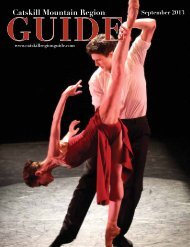
WEDDING ISSUE - Catskill Mountain Foundation
WEDDING ISSUE - Catskill Mountain Foundation
WEDDING ISSUE - Catskill Mountain Foundation

Create successful ePaper yourself
Turn your PDF publications into a flip-book with our unique Google optimized e-Paper software.
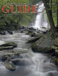
fire tower mountains of the catskill<br />
forest preserve: BALSAM LAKE MOUNTAIN<br />
By Carol and David White, with Laurie Rankin<br />
The fire observer’s cabin on Balsam Lake <strong>Mountain</strong>. Photo by Laurie Rankin<br />
B<br />
alsam Lake <strong>Mountain</strong> is located in the southwestern <strong>Catskill</strong><br />
Forest Preserve, southwest of Belleayre <strong>Mountain</strong>. From<br />
Sunset Lodge on Belleayre’s summit, you can just make out the<br />
fire tower on 3,720-foot Balsam Lake <strong>Mountain</strong>. Of the three<br />
approaches to the summit, the northern approach is most accessible<br />
(see directions). The elevation gain to the trailhead means<br />
that you can summit Balsam Lake <strong>Mountain</strong> with substantially<br />
less climbing than if you approach the mountain from the south¹,<br />
although it’s still an 1100-foot ascent from Mill Brook Road.<br />
Cross the road from the parking area and walk a few yards<br />
right to the blue-marked Dry Brook Ridge trail, which is the old<br />
jeep road to the summit. This first stretch up is a moderate grade<br />
but can be very icy, so bring suitable foot gear such as microspikes,<br />
stabilicers, or crampons. The trail curves around a scenic<br />
rock outcrop, reaches a trail register, and levels out for a substantial<br />
breather before resuming the ascent. Sections can be icy or<br />
wet.<br />
After the trail swings to the right, the grade moderates<br />
somewhat as you climb past great rock ledges; views open up over<br />
terrain that drops steeply down the mountainside. The trail levels<br />
out for a surprising distance before resuming a steadier ascent up<br />
an area open to the west winds and often covered in snowdrifts.<br />
Where the trail levels and swings right, an informal path to nearby<br />
3,868-foot Graham <strong>Mountain</strong> does a nearly hairpin turn left<br />
toward Graham, one of the larger trailless peaks in the <strong>Catskill</strong>s,<br />
with fine winter views. (The path is not obvious in winter. To<br />
hike Graham, which is on private property, seek permission by<br />
contacting William Scholl at 845 586 4056, the caretaker for<br />
Furlough Properties. A guidebook, appropriate <strong>Catskill</strong> map, and<br />
compass/GPS are essential, especially for hiking trailless peaks.)<br />
Proceed on the blue-marked trail toward Balsam Lake <strong>Mountain</strong>,<br />
soon reaching a junction with the red-marked Balsam Lake<br />
Trail at 2.25 miles. Leaving the blue-marked trail, pass a barrier<br />
gate and begin a 0.75-mile steady ascent to the summit. Partway<br />
up, you can see the remnants of an old television relay station on<br />
the summit of Graham to the east. Level trail offers a welcome<br />
breather, followed by final ascents up scenic ledges and a lovely<br />
walk on level terrain through snowy evergreens as you approach<br />
the fire tower. Visit http://beebehill.info/balsamlake/ for more<br />
information.<br />
12 • www.catskillregionguide.com