WEDDING ISSUE - Catskill Mountain Foundation
WEDDING ISSUE - Catskill Mountain Foundation
WEDDING ISSUE - Catskill Mountain Foundation

You also want an ePaper? Increase the reach of your titles
YUMPU automatically turns print PDFs into web optimized ePapers that Google loves.
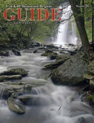
The fire tower Balsam Lake <strong>Mountain</strong>. Photo by Laurie Rankin<br />
Day each year. I volunteered and in 2010, became the volunteer<br />
coordinator for this mountain; our caretaker/volunteers are an<br />
awesome group! They do routine maintenance on the tower,<br />
the cabin, the trails, the spring and the lean-to. They greet and<br />
educate visitors every weekend. The cabin has become a museum<br />
regarding the importance of fire towers and their observers. We<br />
have lots of Smokey the Bear information on plants and animals<br />
as well as fire prevention. We have the history of wildland<br />
fire fighting and the tools that those fire fighters used. We have<br />
pictures, personal stories, and history from Balsam Lake <strong>Mountain</strong><br />
on display, such as when the horses brought the steel up the<br />
mountain for the fire tower. We still have the phone in the cabin,<br />
the old original alidade³ map, hiking maps, and a weather station.<br />
Our volunteers will take you on a tour of the cabin and will<br />
also offer you the opportunity to participate in a scavenger hunt<br />
around the summit area where you can learn more of the history<br />
of the mountain and the unique summit vegetation. Up in the<br />
tower, we have binoculars, hiking maps and our alidade map. Volunteers<br />
explain what you are seeing, including several states on a<br />
clear day! They’ll explain how observers spotted a fire, triangulated<br />
it with other fire towers, phoned it in and either went to fight the<br />
fire or monitored progress from on high.<br />
In 2004, the local ranger needed assistance for a work project<br />
on the mountain and asked my father to help. He and four<br />
generations of our family accomplished the work, and it was fitting<br />
that the sun shone brightly on this mountain caretaker. Dad<br />
still lives close by and we stop in to let him know how things are<br />
on the mountain, who our latest volunteers are, the wildlife we<br />
saw, and the children who climbed. He still cares, as do the many<br />
volunteers who keep the towers, cabins and mountains well taken<br />
care of. The vigilance continues!<br />
¹ If approaching Balsam Lake <strong>Mountain</strong> from the end of Beaver<br />
Kill Road, the ascent to the fire tower is 1600 vertical feet in 1.8<br />
miles, starting on the south end of the Dry Brook Ridge Trail<br />
and then climbing the Balsam Lake <strong>Mountain</strong> Trail to the summit.<br />
A quarter-mile from the summit, the 5.9-mile Mill Brook<br />
Ridge Trail comes in from the east end of Alder Lake; the Beaver<br />
Meadow lean-to is located 1.5 miles from the lake. (Alder Lake is<br />
at the end of County Route 54; see travel directions).<br />
² Among many stories, three Boy Scouts were found by Mr.<br />
Baker after they were reported lost on the mountain. He was<br />
called at 11 pm and found the boys huddled, cold and wet, in the<br />
lean-to about half a mile from the tower. He brought them down<br />
to Mill Brook Road by 5 am and they were returned to camp.<br />
The boys had been hiking with a dozen others for ten miles from<br />
the scout reservation through challenging terrain, and the boys<br />
became separated from their party; half an inch of rain fell on the<br />
mountain and by nightfall they were lost.<br />
³ An alidade is a small mounted telescope used to get an exact<br />
directional sighting on smoke.<br />
To Reach the Trailheads and Parking Areas:<br />
The most accessible approach to Balsam Lake <strong>Mountain</strong> is<br />
south from Route 28 in Arkville on County Route 49 (Dry<br />
Brook Road), just west of the bridge over Dry Brook. Travel<br />
6.1 miles to Mill Brook Road, turn right for 2.2 miles up<br />
Mill Brook Road to the DEC parking area. Because narrow<br />
winding Mill Brook Road climbs about 900 feet, it is best<br />
not to travel in fresh snowfall.<br />
To approach from the south, at Livingston Manor on<br />
I-86/Route 17 exit 96, take the first two right turns. Proceed<br />
0.3 miles, and turn right on County Route 151, which becomes<br />
Route152 and part of Route 54 (same road) for fourteen<br />
miles to Beaver Kill Road. Where Rt. 54 turns north to<br />
Alder Lake after Turnwood, continue straight on Beaver Kill<br />
Road, which is a scenic drive for nine more miles to Quaker<br />
Clearing, the DEC parking area.<br />
Carol and David White are authors of <strong>Catskill</strong> Day Hikes for All<br />
Seasons (Adirondack <strong>Mountain</strong> Club, 2002) and editors of <strong>Catskill</strong><br />
Trails, 3rd edition: Volume 8 (Forest Preserve Series, Adirondack<br />
<strong>Mountain</strong> Club, 2005). Carol is editor of <strong>Catskill</strong> Peak Experiences:<br />
<strong>Mountain</strong>eering Tales of Endurance, Survival, Exploration &<br />
Adventure from the <strong>Catskill</strong> 3500 Club (Black Dome Press, 2008).<br />
Signed copies of all of these books are available at the Village Square<br />
Bookstore and Literary Arts Center in Hunter, NY.<br />
14 • www.catskillregionguide.com