CERES Clouds Working Group Report - NASA
CERES Clouds Working Group Report - NASA
CERES Clouds Working Group Report - NASA

Create successful ePaper yourself
Turn your PDF publications into a flip-book with our unique Google optimized e-Paper software.
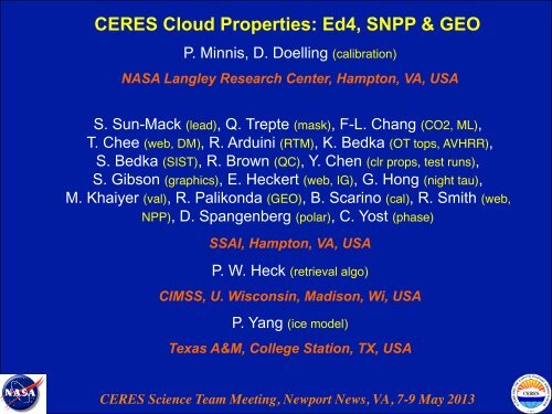
<strong>CERES</strong> Cloud Properties: Ed4, SNPP & GEO<br />
P. Minnis, D. Doelling (calibration)<br />
<strong>NASA</strong> Langley Research Center, Hampton, VA, USA<br />
S. Sun-Mack (lead), Q. Trepte (mask), F-L. Chang (CO2, ML),<br />
T. Chee (web, DM), R. Arduini (RTM), K. Bedka (OT tops, AVHRR),<br />
S. Bedka (SIST), R. Brown (QC), Y. Chen (clr props, test runs),<br />
S. Gibson (graphics), E. Heckert (web, IG), G. Hong (night tau),<br />
M. Khaiyer (val), R. Palikonda (GEO), B. Scarino (cal), R. Smith (web,<br />
NPP), D. Spangenberg (polar), C. Yost (phase)<br />
SSAI, Hampton, VA, USA<br />
P. W. Heck (retrieval algo)<br />
CIMSS, U. Wisconsin, Madison, Wi, USA<br />
P. Yang (ice model)<br />
Texas A&M, College Station, TX, USA<br />
<strong>CERES</strong> Science Team Meeting, Newport News, VA, 7-9 May 2013!
Topics!<br />
• Publications"<br />
• Terra/Aqua – Ed2, Ed4 in process!<br />
• NPP – Ed1, June 2013!<br />
• GEOSat – Ed 1, June 2013!
Update of <strong>CERES</strong> Cloud-related Papers since Oct 2012 !<br />
Edition-2 related!<br />
Stubenrauch, C., W. B. Rossow, S. Kinne, S. Ackerman, G. Cesana, H. Chepfer, B. Getzewich, L. DiGirolamo, A.<br />
Guignard, A. Heidinger, B. Maddux, P. Menzel, P. Minnis, C. Pearl, S. Platnick, C. Poulsen, J. Riedi, S. Sun-<br />
Mack, A. Walther, D. Winker, S. Zeng, and G. Zhao, 2012: Assessment of global cloud datasets from satellites:<br />
Project and database initiated by the GEWEX Radiation Panel. In press, Bull. Am. Meteorol. Soc.<br />
Giannechinni, K., X. Dong, B. Xi., A. Kennedy, P. Minnis, and S. Kato, 2012: Comparison of <strong>CERES</strong>-MODIS<br />
Edition-2 cloud properties with CloudSat/CALIPSO and ground-based measurements at the DOE ARM North<br />
Slope of Alaska site. Submitted, J. Geophys. Res.<br />
Yan, H., J. Huang, P. Minnis, Y. Yi, S. Sun-Mack, T. Wang, and T. Nakajima, 2012: Comparison of <strong>CERES</strong>-MODIS<br />
cloud microphysical properties with surface observations over the Loess Plateau. Submitted to Remote Sens.<br />
Environ.<br />
Edition-4/5 related!<br />
Doelling, D. R., B. R. Scarino, D. Morstad, A. Gopalan, R. Bhatt, C. Lukashin, and P. Minnis, 2013: The calibration<br />
of visible imagers using operational hyperspectral SCIAMACHY radiances. IEEE Trans. Geosci. Remote Sens.,<br />
51, 1245-1254, doi:10.1109/TGRS.2012.2227760.<br />
Scarino, B., P. Minnis, R. Palikonda, R. Riechle, D. Morstad, C. Yost, B. Shan, and Q. Liu, 2013: Deriving surface<br />
skin temperature for NWP applications using global geostationary satellite data. Remote Sens., 5, 342-366, doi:<br />
10.3390/rs5010342.<br />
Painemal, D., P. Minnis, and L. O’Neill, 2013: The diurnal cycle of boundary layer height and cloud cover over the<br />
Southeast Pacific as observed by GOES-10. J. Atmos. Sci., in press.<br />
Hong, G. and P. Minnis, 2013: Effects of inclusions on scattering properties of small ice cloud particles. J. Quant.<br />
Spectros. Rad. Transfer, submitted.
Edition-4 related!<br />
Update of <strong>CERES</strong> Cloud-related Papers, etc. !<br />
Sun-Mack, S., P. Minnis, Y. Chen, S. Kato, Y. Yi, S. Gibson, P. W. Heck, and D. Winker, 2013: Global cloudy<br />
boundary layer apparent lapse rates determined from CALIPSO and MODIS data. Submitted, J. Appl.<br />
Meteorol. Climatol.<br />
Conferences & Other!<br />
Stubenrauch, C., W. B. Rossow, S. Kinne, S. Ackerman, B. Baum, G. Cesana, H. Chepfer, B. Getzewich, L. DiGirolamo, M. Foster,<br />
A. Guignard, A. Heidinger, B. Maddux, P. Menzel, A. Menzies, E. Olson, P. Minnis, F. Parol, C. Pearl, R. Pincus, S. Platnick, C.<br />
Poulsen, J. Riedi, A. Sayer, S. Sun-Mack, et al., 2013: Assessment of global cloud datasets from satellites. World Climate Res.<br />
Prog. GEWEX Radiation Panel, WCRP <strong>Report</strong> No. 23/2012, November, 176 pp.<br />
Painemal, D. and P. Minnis, 2012: Satellite-based investigation of the boundary layer diurnal cycle over the Southeast Pacific. AGU<br />
Fall Mtg 2012, 3-7 December, San Francisco, CA, A23C-0236.<br />
Palikonda, R., P. Minnis, T. Chee, K. Bedka, L. Nguyen, M. L. Nordeen, and B. Shan, 2012: Development of a near real time global<br />
geostationary cloud and radiation product. AGU Fall Mtg 2012, 3-7 December, San Francisco, CA, IN41B-1495.<br />
Yost, C. R., P. Minnis, Q. Trepte, R. Palikonda, J. K. Ayers, and D. A. Spangenberg, 2012: Using information from prior satellite<br />
scans to improve cloud detection near the day/night terminator. AGU Fall Mtg 2012, 3-7 December, San Francisco, CA,<br />
A11B-0040.<br />
Loeb, N., D. R. Doelling, S. Kato, D. P. Kratz, P. Minnis, K. J. Priestley, P. W. Stackhouse, W. Su, and T. Wong, 2013: Overview of<br />
the <strong>Clouds</strong> and the Earth's Radiant Energy System (<strong>CERES</strong>). 9 th AMS Ann. Symp. Future Operational Environ. Satellite<br />
Systems, Austin, TX, January 6-10.<br />
Doelling, D., K. Khlopenkov, A. Okuyama, and P. Minnis, 2013: Development of the MTSAT-1 visible footprint point spread<br />
function. GSICS Ann. Mtg., Williamsburg, VA, Mar. 4-8.<br />
Minnis, P., K. Bedka, R. Palikonda, Q. Trepte, P. Heck, B. Scarino, S. Bedka, C. Yost, R. Bhatt, A. Gopalan, K. Khlopenkov, G.<br />
Hong, and D. Doelling, 2013: A <strong>CERES</strong>-consistent cloud property and surface temperature climate data rcord using AVHRR<br />
data. NOAA 2013 Satellite Conf. Direct Readout, GOES/POES, and GOES-R/JPSS Users, College Park, MD, April 8-12.<br />
Scarino, B., P. Minnis, R. Palikonda, C. Yost, B. Shan, R. Reichle, and Q. Liu, 2013: Surface skin temperature from geostationary<br />
satellite data. NOAA 2013 Satellite Conf. Direct Readout, GOES/POES, and GOES-R/JPSS Users, College Park, MD, April<br />
8-12.
Cloud Parameters in <strong>CERES</strong> Edition 2!<br />
Cloud Mask, Phase<br />
Optical Depth, IR emissivity<br />
Effective Radius/Diameter<br />
Liquid/Ice Water Path<br />
Cloud Effective Temperature<br />
Cloud Top/ Bottom Pressure<br />
Cloud Effective Pressure<br />
Cloud Effective Height<br />
Clear-sky Temperature<br />
All data only available in SSF or 1° averages!
New Cloud Parameters in <strong>CERES</strong> Edition 4!<br />
New Size Retrievals<br />
CO2 Slicing<br />
Water droplet eff radius (1.24 µm) Cloud Top Pressure<br />
Ice effective radius (1.24 µm) Cloud Top Temperature<br />
Water droplet eff radius (2.1 µm) Cloud Top Height<br />
Ice effective radius (2.1 µm)<br />
IR Emissivity<br />
Multilayer Cloud Retrieval ( Ice Over Water )<br />
Multilayer Identification<br />
Upper Layer (Ice <strong>Clouds</strong>) Lower Layer (Water <strong>Clouds</strong>)<br />
Cloud Top Pressure<br />
Lower<br />
Cloud<br />
layer!<br />
Top Pressure<br />
Cloud Top Temperature<br />
cloud Cloud top! Top Temperature<br />
Cloud Top Height<br />
Cloud Top Height<br />
Cloud Visible Optical Depth Cloud Visible Optical Depth<br />
Ice Effective Radius (3.7 µm) Water Droplet Radius (3.7 µm)<br />
Ice Effective Radius (2.1 µm) Water Droplet Radius (2.1 µm)<br />
All data available in SSF, 1° averages, & at pixel level!
MODIS Processing Status!<br />
• Ed2 processing!<br />
!- Aqua: through February 2013, will continue until ED4 ADMs completed!<br />
!- Terra: through February 2013, will continue until Ed4 ADMs completed!<br />
! !!<br />
• Ed4 re-delivered in February: known as Ed4 Beta-2, based on Coll. 5 data!<br />
!!<br />
!- Revised boundary layer lapse rates!<br />
!- CO2-slicing bug fixed!<br />
!<br />
! !!
MODIS Edition-4 beta 2!<br />
• Mistake in use of MODIS cloud top temperatures in derivation of lapse rates!<br />
!!<br />
!- lapse rates rerun!<br />
!- reran independent dataset and performed comparisons with other methods!<br />
!- <strong>CERES</strong> regional approach most accurate to date!<br />
!<br />
• CO2 code bug discovered and corrected!<br />
!- much improved, multilayer fraction!
• Alteration of Terra 3.7-µm Collection-5 calibration seems to have worked<br />
well for polar night, Aqua and Terra now very similar in Antarctica!<br />
MODIS Total Cloud Amounts, June 2006!<br />
Aqua Ed 2 ! ! ! !Terra Ed 2!<br />
Aqua Ed 4 ! ! ! !Terra Ed 4!
• Alteration of Terra 3.7-µm Collection-5 calibration seems to have worked<br />
well for polar night, Aqua and Terra now very similar in Arctic!<br />
MODIS Total Cloud Amounts, January 2007!<br />
Aqua Ed 2 ! ! ! !Terra Ed 2!<br />
Aqua Ed 4 ! ! ! !Terra Ed 4!
Low Cloud Heights!<br />
!<br />
• Ed2 used 7.1 K/km lapse rate anchored to surface to assign cloud<br />
height below 700 hPa!<br />
! ! ! ! ! !- Minnis et al. (2011)!<br />
!<br />
• Ed3 would have used zonal mean lapse rate based on MODIS-<br />
CALIPSO data!<br />
! ! ! ! ! !- Minnis et al. (2010)!<br />
!<br />
• Ed4 uses regional lapse rates based on MODIS-CALIPSO data!<br />
! ! ! ! ! !- Sun-Mack et al. (2013)!<br />
!<br />
!
Daytime boundary layer lapse rates (K km -1 ) over snow/ice-free scenes<br />
Ed-4 Beta1, July 2006 - June 2007 !<br />
Spring (Mar,Apr,May)!<br />
Summer (Jun,Jul,Aug)!<br />
Fall (Sep,Oct,Nov)!<br />
Winter (Dec,Jan,Feb)!
Daytime boundary layer lapse rates (K km -1 ) over snow/ice-free scenes<br />
Ed-4 Beta2, July 2006 - June 2007 !<br />
• Gradients different from Beta1 in most cases!<br />
!
Daytime low-cloud top height differences, MODIS – CALIPSO, for MODIS<br />
retrievals over snow-free scenes using six methods, October 2007 !<br />
!
Instantaneous Low Cloud Height Difference Statistics (km)!<br />
MODIS - CALIPSO!<br />
• <strong>CERES</strong> Ed4 clearly most accurate overall!
Regional Mean Daytime Low Cloud Height Differences (km)!<br />
Ed-4 Beta2, October 2007 !<br />
!
Regional Mean Nighttime Low Cloud Height Differences (km)!<br />
Ed-4 Beta2, October 2007 !<br />
!
Regional Mean Low Cloud Height Difference Statistics (km)!<br />
MODIS - CALIPSO!
Terra!<br />
Water Cloud Effective Height<br />
Changes Relative to Ed 2!<br />
Ed4 – Ed2 (km)!<br />
Day, January 2007!<br />
Aqua!<br />
• Terra: smaller changes than<br />
Aqua!<br />
!- larger lapse rates !<br />
!- fewer clouds with phase<br />
!change!<br />
!<br />
• Aqua: mostly increases!<br />
! !- some drops in Sc<br />
areas!<br />
! !- more supercooled<br />
clouds,!<br />
! ! so higher clouds!<br />
!<br />
• Overall: 0.5 km increase!<br />
!<br />
• Cloud-top height: 0.06 km<br />
higher to yield 0.56 km<br />
increase relative Ed2!
Terra ! ! ! ! Terra!<br />
7/06 ! ! ! ! 1/07!<br />
Water Cloud Height<br />
Changes Relative to Ed 2!<br />
Ed4 – Ed2 (km)!<br />
Aqua ! ! Aqua!<br />
7/06 ! ! 1/07!<br />
• Land: Most heights up by<br />
0.3 – 1.2 km!<br />
!- some drops in SH!<br />
!- should be closer to<br />
!CALIPSO now!<br />
!<br />
• Ocean: heights up by 0.0 –<br />
0.5 km!<br />
! !- some drops in SH!<br />
!<br />
• Changes due to !<br />
! !- lapse rates!<br />
! !- phase changes!
Terra!<br />
Ice Cloud Effective Height<br />
Changes Relative to Ed 2!<br />
Ed4 – Ed2 (km)!<br />
Day, January 2007!<br />
Aqua!<br />
• Terra & Aqua: similar changes!<br />
!- impact of CO2, 1.38 µm,!<br />
! phase changes, ice cloud<br />
! model!<br />
!<br />
• Overall difference (km)!<br />
!- Polar: ! -0.05!<br />
!- Non-Polar: ! 1.33!<br />
!- Global: ! 1.39!<br />
!<br />
• Cloud-top height: 0.72 km<br />
higher than cloud effective<br />
height!<br />
!- overall increase of 2.11 km!<br />
!- should agree better with<br />
!CALIPSO!<br />
!
Ed2 to Ed4 Optical Depth Changes!<br />
---- A number of changes impact cloud optical depth!<br />
• Correct ozone absorption will decrease COD !<br />
• New cloud retrievals over snow will increase COD!<br />
!- Aqua Ed2 biased low!<br />
!- T & A Ed2 threw out many large COD clouds!<br />
• Detection of optically thin cirrus with 1.38 µm will decrease ice COD!<br />
!- assume a temperature and Re, perform IR retrieval!<br />
• Use of new rough ice crystal models can raise or lower COD!<br />
• Max COD =150, was 128!<br />
Ed4 - Ed2 COD!<br />
• COD rose in snow areas!<br />
!<br />
• COD up in deep convective<br />
areas!<br />
!<br />
• decreased in midlatitudes!<br />
!<br />
• decreased slightly in<br />
subtropics!
Terra!<br />
Aqua!<br />
Change Water droplet Effective Radius: Ed4 – Ed2!<br />
July 2006!<br />
• Terra & Aqua: different changes!<br />
!- Terra, new 3.7 calib!<br />
!- both: more cumulus detected!<br />
! !phase changes!<br />
!<br />
• Overall change (µm)!<br />
! Ocean ! Terra ! Aqua!<br />
!- Polar: ! 0.11 ! 0.37!<br />
!- Non-Polar: ! 0.57 ! 0.12!<br />
!- Global: ! 0.53 ! 0.14!<br />
!<br />
! Land ! ! Terra ! Aqua!<br />
!- Polar: ! 0.80 ! 0.59 !<br />
!- Non-Polar: ! 1.02 ! 0.87!<br />
!- Global: ! 1.04 ! 0.85!<br />
!<br />
• Land change mainly to 9% increase<br />
in water cloud cover!<br />
! !- new clouds!<br />
! !- former ice clouds!<br />
!<br />
• LWP changed by 20% and 6% in Aqua & Terra results!
Change Ice Crystal Effective Radius: Ed4 – Ed2!<br />
July 2006!<br />
Terra!<br />
• Terra & Aqua: different changes!<br />
!- Aqua, more phase changes!<br />
!- both: more zonal dependence!<br />
! !- drop in tropics, increase<br />
midlat!<br />
! !- new ice xtal model?!<br />
! Aqua!<br />
Re!<br />
!<br />
Aqua!<br />
0.1 µm!<br />
2.3 µm!<br />
0.7 µm!<br />
• IWP changed by 5% and 2% in Aqua & Terra results!
MODIS Edition 4 Tasks!<br />
• Continue validation!<br />
!- see B. Xi & X. Dong talks!<br />
!- other ground site and satellite comparisons!<br />
!<br />
• Complete Ed-4 documentation!<br />
!!<br />
• Determine differences in Coll 6 vs <strong>CERES</strong>-altered Coll 5 data!<br />
!- use overlapped months to see if calibration problems !<br />
! disappeared!<br />
!- adjust codes as needed to smoothly use Coll 6!<br />
!<br />
!- perform repeat cross calibration!<br />
• Refine techniques when possible!<br />
!<br />
!- respond to feedback from downstream!<br />
• Continue processing!
VIIRS Edition 1 Tasks!<br />
• Develop reader for new format (Sunny) !<br />
• Acquire necessary auxiliary information!<br />
!- corr-k coefficients (done)!<br />
!- solar constant !<br />
!- reflectance/emittance models!<br />
! !- e.g., 2.25 µm from P. Yang!<br />
!- test in code!<br />
• Tune cloud masks (Qing)!<br />
!- use matched CALIPSO & Aqua data as guide!<br />
!- polar need adjustments, new snow model adjustment!<br />
• Cross calibrate Aqua and VIIRS!<br />
• Develop QC and graphical software!<br />
• Perform independent validations!<br />
!- ARM sites!<br />
!- other satellite data!<br />
• Work on BTD multilayer code using MODIS (see Chang talk)!<br />
!- move to VIIRS!<br />
• Deliver Ed1, End of June 2013!
VIIRS Spectral Channels!
Prettying Up VIIRS<br />
Imagery!<br />
Before!<br />
!<br />
!<br />
!<br />
!<br />
!<br />
!<br />
!<br />
!<br />
!<br />
!<br />
!<br />
After!<br />
• linear gaps filled by<br />
averaging adjacent<br />
pixels along the lines !
• Acquire necessary auxiliary<br />
information!<br />
!- corr-k coefficients !<br />
!- solar constant !!<br />
- reflectance/emittance models !<br />
! e.g., 2.25 instead of 2.13 µm!<br />
! ! !!<br />
• imaginary index of refraction!<br />
!water ! ! ice!<br />
2.13 4.32 x 10 -4 ! 5.5 x 10 -4 !<br />
2.25 3.80 x 10 -4 ! 2.1 x 10 -4!<br />
!<br />
• ice less absorptive than water at<br />
2.2 µm, affects cloud detection<br />
and phase selection, as well as<br />
particle sizes!<br />
Aqua!<br />
VIIRS!
• Ratios of 2.25/0.65 µm<br />
reflectance used in mask!<br />
!- need to adjust ratios to<br />
! account for snow<br />
! !<br />
reflectance differences!<br />
!<br />
• Will need changes over<br />
other surfaces, particularly<br />
deserts!<br />
VIIRS Mask Tuning !<br />
What a difference 0.1 µm makes!
VIIRS Cloud Fraction Comparison w/ Aqua!<br />
Daytime 3 days, Nov 2012 !<br />
Aqua!<br />
VIIRS!<br />
• Reasonably similar, except over snow<br />
& desert!<br />
!- corr-k for MODIS!<br />
!- clear-sky reflectances need<br />
!improvement!<br />
!<br />
• daytime difference = 0.031!<br />
!- mainly over poles & deserts!<br />
!<br />
• night difference = 0.008!<br />
!- mainly over poles & deserts!<br />
!<br />
!
VIIRS Cloud Fraction<br />
Comparison w/ Aqua!<br />
Daytime 3 days, Nov 2012 !<br />
• Daytime polar difference up to 0.4!<br />
!<br />
• Night polar 0.2 over Antarctica!<br />
!<br />
• Desert bias day and night!<br />
!<br />
!
VIIRS Cloud Detection!<br />
• Tune cloud masks !<br />
!- use matched CALIPSO & Aqua data as guide!<br />
! !- CALIPSO matching with VIIRS!<br />
! !- Aqua matching!<br />
!<br />
!- polar day & night adjustments underway!<br />
!<br />
! !- no WV or CO2 channels !<br />
!- new background maps from a first year run!<br />
! !- 2.25 µm DRMs and surface albmap (Yan)!<br />
! !- new snow albedos by adjusting 2.13 values!<br />
! !- or use 1.6 µm !
VIIRS Cloud Height Difference w/ Aqua!<br />
Daytime 3 days, Nov 2012 !<br />
Water!<br />
Ice!<br />
• Very similar, some larger differences<br />
may reflect orbit path differences!<br />
!- VIIRS higher by 0.119 km for water!<br />
! ! by 0.098 km for ice!<br />
! !- absence of CO2 does not<br />
! hurt too much!<br />
!- at night, VIIRS higher by 0.070 km!<br />
!
VIIRS Water Cloud COD Comparison w/ Aqua!<br />
VIIRS MEAN!<br />
3 days, Nov 2012!<br />
VIIRS - MODIS!<br />
• Small differences, but for thickest<br />
clouds!<br />
!- corr-k for MODIS!<br />
!- phase selection differences!<br />
!- solar constant!<br />
!<br />
!- VIIRS COD greater by 3.7 !<br />
! !!<br />
!
VIIRS Water Cloud Re Comparison w/ Aqua!<br />
Daytime 3 days, Nov 2012 !<br />
Aqua!<br />
VIIRS!<br />
• Patterns similar, VIIRS smaller !!<br />
!- corr-k for MODIS!<br />
!- VIIRS 2 µm smaller over ocean!<br />
! ! 1.2 µm smaller over land!<br />
!<br />
• Smaller VIRS not surprising!<br />
!- 3.7-µm brighter than MODIS 3.8 µm!<br />
!!<br />
!
Whatʼs Ahead for <strong>CERES</strong> SNPP VIIRS!<br />
• Set up to run VIIRS through system!<br />
!<br />
• corr-k changes, cloud reflectance models, VIIRS solar constants<br />
!to be incorporated this week!<br />
!<br />
• background maps and snow models will be updated!<br />
!<br />
• Mask will be tuned!<br />
!<br />
• initial validations will be tuned!<br />
!<br />
• Multilayer algorithm will be tested!<br />
!<br />
• Deliver Ed1, End of June 2013!<br />
!!
Hourly GEOSat Data for TISA!<br />
!<br />
• Available geostationary satellites provide up to 1-hour global monitoring<br />
between ~60°S and ~60°N!<br />
• <strong>CERES</strong> Ed2 cloud retrieval algorithm (VISST/SIST) from MODIS adapted<br />
for geostationary satellite data processing!<br />
!<br />
!<br />
!<br />
G15 <br />
G13 <br />
Met9 <br />
FY2E <br />
MTSAT-‐2 <br />
• FY-2 series will not be included in TISA analysis because of unreliability!<br />
Meteosat-7 & 2-channel algorithm will be used for the gap !<br />
• Currently running in near-real time, will process backward in time!<br />
!- GMAO working on assimilation of these data!
Meteosat-9 vs Aqua Cloud Amounts, Daytime!<br />
• Better agreement with 5 channel code!
Meteosat-9 vs Aqua Cloud Amounts, Night!<br />
• Meteosat higher by 3% both months!<br />
!<br />
• Correlations with other parameters look quite good also!
GEOSat Cloud Fraction, March 2013!<br />
day!<br />
Zonal Means vs. Aqua Ed2,<br />
March 2012!<br />
night!<br />
• GOES has too much cloud at night, Meteosat too little over ocean!<br />
!- mask adjustments needed!
Meteosat-9 vs Aqua Cloud Top Pressure, April 2010!<br />
• Big differences with GOES, need further calibration analysis!
GEOSat Tasks!<br />
• Validate calibrations, determine source of discontinuities!<br />
!- GOES especially, !<br />
!- perform detailed comparisons with all GEOSats !<br />
!<br />
• Tune cloud masks, needed!<br />
!!<br />
• Test & implement nighttime thick ice cloud algorithm!<br />
!<br />
• Develop fixes for twilight parameters!<br />
!- cloud amount not too bad, but other parameters (height)!<br />
!<br />
• Process gobs of data!<br />
!- need allocation of resources on AMIE & storage!<br />
!- alter code to work on AMIE!