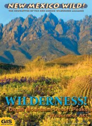
Special Mobile GIS Issue - New Mexico Wilderness Alliance
Special Mobile GIS Issue - New Mexico Wilderness Alliance
Special Mobile GIS Issue - New Mexico Wilderness Alliance

Create successful ePaper yourself
Turn your PDF publications into a flip-book with our unique Google optimized e-Paper software.
mapping wilderness<br />
<strong>Mobile</strong> <strong>GIS</strong>:<br />
Revolutionizing<br />
<strong>Wilderness</strong> Inventory<br />
By Rachel Freund<br />
Spring is just around the<br />
corner, and the <strong>New</strong><br />
<strong>Mexico</strong> <strong>Wilderness</strong> <strong>Alliance</strong><br />
is gearing up for<br />
another exciting field<br />
season. You may already<br />
know that the <strong>Wilderness</strong><br />
<strong>Alliance</strong> offers dozens of hikes and<br />
volunteer service projects every year, but<br />
did you know that this season there’s yet<br />
another way you can get outside, get involved,<br />
and give back to the wild public<br />
lands you cherish?<br />
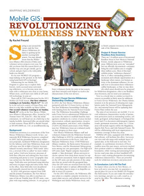
It’s our new MOBILE <strong>GIS</strong> program—<br />
map-making on the ground, in the field,<br />
using hand-held GPS technology!<br />
Volunteering for our <strong>Mobile</strong> <strong>GIS</strong><br />
Program is a great way to explore littleknown,<br />
rarely accessed areas surrounding<br />
wilderness—or to become more intimate<br />
with a wilderness area close to your home.<br />
What’s more, you’ll learn new skills in GPS and<br />
<strong>GIS</strong> technology. So join us!<br />
There will be TWO introductions for the 2011<br />
<strong>Mobile</strong> <strong>GIS</strong> Field Season. Our first volunteer<br />
training is on Saturday, March 12 th . We will<br />
be in the red rock country of Petaca Pinta, and<br />
there is a day hike available up Mesa Gallina.<br />
Our second volunteer training is on Sunday,<br />
March 13 th at the at the <strong>New</strong> <strong>Mexico</strong> <strong>Wilderness</strong><br />
<strong>Alliance</strong>’s Albuquerque office, located at 142<br />
Truman Street NE, Suite B-1. After the initial<br />
orientation, we will head out on a field trip to the<br />
Sandia foothills. Interested folks can attend either<br />
or both sessions. Please RSVP to Rachel Freund<br />
at 505-843-8696 ext. 110, or news@nmwild.org.<br />
Background<br />
<strong>Wilderness</strong> inventory is a cornerstone of the <strong>New</strong><br />
<strong>Mexico</strong> <strong>Wilderness</strong> <strong>Alliance</strong>’s work. In fact, our<br />
statewide BLM <strong>Wilderness</strong> Inventory completed<br />
in 2005, laid the groundwork for many wilderness<br />
proposals, facilitated <strong>Wilderness</strong> designation<br />
for the Sabinoso and Ojito <strong>Wilderness</strong> Areas, and<br />
will enjoy new life in light of Interior Secretary<br />
Salazar’s recently announced “Wild Lands” directive,<br />
a reversal of the so-called “no more wilderness”<br />
policy. Until now, however, processes of<br />
field data collection and editing have been timeconsuming<br />
and prone to error. Geographic data<br />
was carried into the field in the form of paper<br />
maps. Field edits were performed using sketches<br />
and notes on paper maps and entry forms. Back<br />
in the office, these field edits were deciphered<br />
and manually entered into the <strong>GIS</strong> database.<br />
In 2010, with generous support from ESRI<br />
and the Jeniam Foundation, the <strong>New</strong> <strong>Mexico</strong><br />
<strong>Wilderness</strong> <strong>Alliance</strong> was able to purchase six<br />
state-of-the-art Trimble Juno SB GPS units, complete<br />
with map-making software. A core group of<br />
brave volunteers broke the units in last season,<br />
and these intrepid souls helped us resolve the<br />
idiosyncrasies of the new devices.<br />
Project I: Forest Service <strong>Wilderness</strong><br />
Stewardhip Challenge<br />
In 2010, the <strong>New</strong> <strong>Mexico</strong> <strong>Wilderness</strong> <strong>Alliance</strong><br />
partnered with the US Forest Service on their<br />
Ten-Year <strong>Wilderness</strong> Stewardship Challenge,<br />
with funding from the National Forest Foundation.<br />
The <strong>Wilderness</strong> Stewardship Challenge<br />
tasks Forest Service-administered <strong>Wilderness</strong> Areas<br />
across the nation to establish baseline management<br />
conditions in a variety of areas (including<br />
recreation, solitude opportunities, invasive<br />
plant management, and more), with a deadline<br />
of 2014, the fiftieth anniversary of the <strong>Wilderness</strong><br />
Act. <strong>Wilderness</strong> Areas are evaluated yearly<br />
on their progress in these areas.<br />
<strong>New</strong> <strong>Mexico</strong> <strong>Wilderness</strong> <strong>Alliance</strong> staff and<br />
volunteers helped with the <strong>Wilderness</strong> Stewardship<br />
Challenge in 2010 by conducting dispersed<br />
campsite inventories in the Pecos, Latir, and<br />
Manzano <strong>Wilderness</strong> Areas. UNM <strong>Wilderness</strong><br />
<strong>Alliance</strong> students, the Backcountry Horsemen of<br />
<strong>New</strong> <strong>Mexico</strong>, and the Mountainair hiking group<br />
were among our core participants. Our high-tech<br />
GPS units made “Rapid Campsite Assessment”<br />
simple: a “data dictionary” allows surveyors to<br />
choose options from drop-down menus for rapid,<br />
consistent assessment; built-in digital cameras<br />
on the GPS units can take pictures of the campsites<br />
that are stored with the geospatial data.<br />
Once the GPS units are returned from the field,<br />
it is a simple matter to upload, differentially correct,<br />
and share data in maps or as shapefiles usable<br />
in most <strong>GIS</strong> systems.<br />
For the 2011 field season, the <strong>Wilderness</strong> <strong>Alliance</strong><br />
plans to complete campsite inventories, invasive<br />
plant surveys, and solitude surveys in the<br />
Withington and Sandia <strong>Wilderness</strong> Areas, and<br />
to finish campsite inventory on the west<br />
side of the Manzanos.<br />
Project II: Forest Service<br />
Roadless Area Inventory<br />
There are 1.6 million acres of Inventoried<br />
Roadless Areas in <strong>New</strong> <strong>Mexico</strong>’s National<br />
Forests, mostly adjacent to <strong>Wilderness</strong><br />
areas. Millions more acres are “unroaded”<br />
but not officially documented—estimates<br />
bring the total roadless area to roughly<br />
three million acres. Most of this land<br />
exhibits prime “wilderness character”;<br />
that is, it offers outstanding primitive<br />
recreation and solitude opportunities in a<br />
landscape where nature, not human activity,<br />
is the dominant influence. It’s our<br />
task now to document these wildernesscaliber<br />
landscapes, so that we may identify<br />
which areas should next be proposed<br />
for <strong>Wilderness</strong> designation—this is our Roadless<br />
Area Inventory, and we need your assistance.<br />
Now is a crucial time to conduct as much inventory<br />
as possible in likely areas for additions<br />
to Forest Service <strong>Wilderness</strong>: the Obama Administration<br />
is in the process of releasing new regulations<br />
under the National Forest Management<br />
Act, and national forests will be updating their<br />
Forest Plans within the year.<br />
The aims of our inventory are twofold: 1) to record<br />
wilderness characteristics worthy of permanent<br />
protection (such as outstanding scenery; solitude;<br />
geological, archaeological, or biological features)<br />
and 2) to document anthropogenic impacts<br />
(roads, permanent structures, dams, etc.). Focus<br />
areas will include regions within the Magdalena,<br />
Apache Kid, Pecos, and Gila National Forests. We<br />
will be collaborating with local organizations to<br />
maximize coverage of these key areas.<br />
NMWA’s GPS units, equipped with ESRI’s Arc-<br />
Pad software, will facilitate this effort. Surveyors<br />
can view and edit maps with multiple layers of<br />
spatial data, in the field and in real time. For<br />
example, in a preliminary inventory of Pecos<br />
roadless areas this past season, surveyors tracked<br />
their position relative to wilderness and roadless<br />
boundaries, while viewing and annotating Forest<br />
Service road route data on their handheld GPS<br />
devices—and creating photopoints documenting<br />
wilderness characteristics. These are powerful<br />
tools for wilderness inventory and protection!<br />
In Conclusion: Let’s Hit The Trail<br />
No matter where you live in <strong>New</strong> <strong>Mexico</strong>, or<br />
how tech-savvy you may feel, we guarantee a<br />
special place for you in our <strong>Mobile</strong> <strong>GIS</strong> Program<br />
this field season. If you can’t make the introductory<br />
meetings, just give us a call, e-mail us, or<br />
stop by the office. The wilderness is waiting<br />
for you! <br />
www.nmwild.org 13