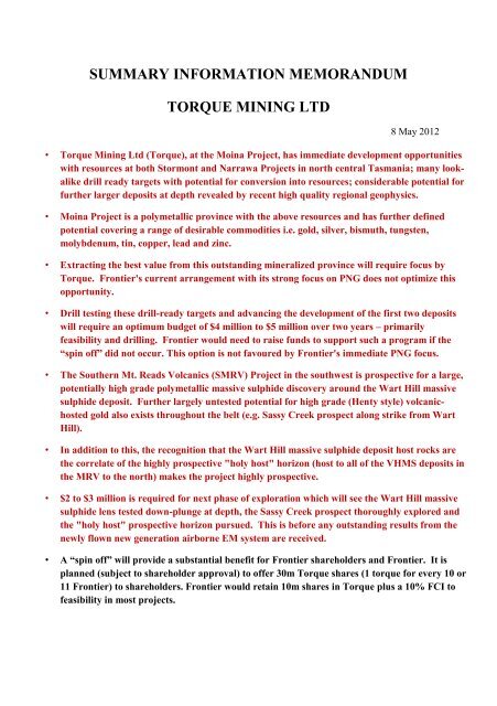
SUMMARY INFORMATION MEMORANDUM TORQUE MINING LTD
SUMMARY INFORMATION MEMORANDUM TORQUE MINING LTD
SUMMARY INFORMATION MEMORANDUM TORQUE MINING LTD

You also want an ePaper? Increase the reach of your titles
YUMPU automatically turns print PDFs into web optimized ePapers that Google loves.
<strong>SUMMARY</strong> <strong>INFORMATION</strong> <strong>MEMORANDUM</strong><br />
<strong>TORQUE</strong> <strong>MINING</strong> <strong>LTD</strong><br />
8 May 2012<br />
• Torque Mining Ltd (Torque), at the Moina Project, has immediate development opportunities<br />
with resources at both Stormont and Narrawa Projects in north central Tasmania; many lookalike<br />
drill ready targets with potential for conversion into resources; considerable potential for<br />
further larger deposits at depth revealed by recent high quality regional geophysics.<br />
• Moina Project is a polymetallic province with the above resources and has further defined<br />
potential covering a range of desirable commodities i.e. gold, silver, bismuth, tungsten,<br />
molybdenum, tin, copper, lead and zinc.<br />
• Extracting the best value from this outstanding mineralized province will require focus by<br />
Torque. Frontier's current arrangement with its strong focus on PNG does not optimize this<br />
opportunity.<br />
• Drill testing these drill-ready targets and advancing the development of the first two deposits<br />
will require an optimum budget of $4 million to $5 million over two years – primarily<br />
feasibility and drilling. Frontier would need to raise funds to support such a program if the<br />
“spin off” did not occur. This option is not favoured by Frontier's immediate PNG focus.<br />
• The Southern Mt. Reads Volcanics (SMRV) Project in the southwest is prospective for a large,<br />
potentially high grade polymetallic massive sulphide discovery around the Wart Hill massive<br />
sulphide deposit. Further largely untested potential for high grade (Henty style) volcanichosted<br />
gold also exists throughout the belt (e.g. Sassy Creek prospect along strike from Wart<br />
Hill).<br />
• In addition to this, the recognition that the Wart Hill massive sulphide deposit host rocks are<br />
the correlate of the highly prospective "holy host" horizon (host to all of the VHMS deposits in<br />
the MRV to the north) makes the project highly prospective.<br />
• $2 to $3 million is required for next phase of exploration which will see the Wart Hill massive<br />
sulphide lens tested down-plunge at depth, the Sassy Creek prospect thoroughly explored and<br />
the "holy host" prospective horizon pursued. This is before any outstanding results from the<br />
newly flown new generation airborne EM system are received.<br />
• A “spin off” will provide a substantial benefit for Frontier shareholders and Frontier. It is<br />
planned (subject to shareholder approval) to offer 30m Torque shares (1 torque for every 10 or<br />
11 Frontier) to shareholders. Frontier would retain 10m shares in Torque plus a 10% FCI to<br />
feasibility in most projects.
INTRODUCTION<br />
Torque is a mineral exploration/development company planning to list on the ASX. It intends to engage in<br />
the exploration for and, subject to proposed feasibilities studies, the development of, and mining of mineral<br />
deposits in Tasmania.<br />
Targeted commodities are many as the project areas collectively cover a wide range of mineralization styles<br />
and geological settings. Specific opportunities are:<br />
<br />
<br />
<br />
<br />
<br />
Gold+/-bismuth+/-base metals in skarn style deposits associated with intrusive granites (e.g.<br />
current resources at Stormont and Narrawa Creek) - Moina Project<br />
Gold in disseminations and/or veins associated with intrusive granite (e.g. Pogo and Fort Knox,<br />
Canada) - Moina Project<br />
High grade zinc+lead+gold+silver in Volcanic Hosted Massive Sulphide style (e.g. Rosebery,<br />
Hellyer and Mt Lyell, Tas.) – SMRV and Moina Projects;<br />
Tungsten+/-molybdenum+/-bismuth+/-tin in vein or skarn deposits (e.g. Shephard and Murphy,<br />
King Island and Kara, Tas.) – Moina, Lower Pieman and NE Tasmania Projects.<br />
Tin as disseminations in "greisen" altered granite and/or replacement/skarn tin deposits (e.g. Mt<br />
Bischoff and Renison, Tas.) – Moina, NE Tasmania and Lower Pieman Projects<br />
These Tasmanian projects were held by Frontier Resources Ltd (Frontier), an Australian Securities<br />
Exchange (ASX) listed company and were transferred to wholly owned subsidiary Torque Mining Ltd on<br />
approximately 26 th April 2012. Frontier and its predecessors have explored the SMRV Project since 1997<br />
and the Moina Project since 2002 and recently acquired the Lower Pieman and NE Tasmania Projects..<br />
Frontier has carried out significant drilling, geochemical and geophysical surveys on both the Moina<br />
and SMRV Projects and Inferred and Indicated Mineral resources have been defined at the Moina<br />
Project. Frontier’s total exploration expenditure in Tasmania on these and other projects since 2002<br />
has been approximately $8.6 million. In addition Frontier’s “parent”, Macmin (or JV partners) spent<br />
approximately $1.2 million between 1993 and 2002.<br />
Frontier has defined small to medium sized gold-/bismuth-/base metal/tungsten and tin resources at<br />
Moina and also demonstrated a substantial upside for discovery, where resources are likely to<br />
increase with additional exploration. At the SMRV Project Frontier has defined high-grade<br />
polymetallic zinc-lead-silver mineralisation similar to the Rosebery mine/deposit.<br />
Torque has acquired the interests of Frontier Resources Ltd (Frontier) in Tasmania, namely EL’s 42/2010,<br />
20/96, 33/2010, 27/2011, 29/2009, 6/2011, 21/2011, 3/2011 and RL 3/2005. Consideration to Frontier was<br />
the issuance of 40 million Torque shares and a 10% free carried interest (FCI) to bankable feasibility study<br />
(BFS)in all tenements except EL’s 20/96 and 33/2010 (which are already subject to a 10% FCI to BFS). It is<br />
intended that 30 million of Frontier’s shares in Torque will be offered to Frontier shareholders by in specie<br />
distribution, subject to Frontier shareholder and regulatory approval, on or around 1 July 2012.<br />
Under the JORC Code, provision has been made to allow an expert to estimate potential target sizes to<br />
provide an opinion as to the potential of a particular mineralised zone. In this report this has been done<br />
using three broadly generalised quantitative terms: large, medium and small. For example:<br />
<br />
<br />
<br />
“Small” is applied where the deposit potential may range up to a few hundred thousand tonnes;<br />
“Medium” is applied where the deposit potential may range from small to a few million tonnes; and<br />
“Large” is applied where the deposit potential may range from medium to hundreds of million of<br />
tonnes<br />
2
TABLE 1.<br />
MAJOR METALLIC MINERAL DEPOSITS OF TASMANIA<br />
(Source Mineral Resource Tasmania and others)<br />
Mine<br />
Tonnages<br />
or Deposit Mineral Style Commodity (Production + Reserves)<br />
Beaconsfield Structurally controlled/veins Au 2 million oz production<br />
Mt Lyell Volcanic Hosted Disseminated Cu,Au 135Mt at 1.2%Cu and 0.4g/t Au<br />
Rosebery Volcanic hosted massive Zn,Pb, 32+Mt at 0.6%Cu, 14.6%Zn,<br />
sulphide Ag,Cu 4.6%Pb, 146g/tAg & 2.3g/t Au<br />
Au<br />
Hellyer Volcanic hosted massive Zn,Pb, 15.5Mt at 0.4%Cu, 14.3%Zn,<br />
sulphide Ag,Cu, 5.9%Pb, 140g/tAg, & 2.2g/t Au<br />
Au<br />
Que River Volcanic hosted massive Zn,Pb, 2.5Mt at 0.45%Cu, 7.5%Pb<br />
Sulphide Ag,Cu, 13.6%Zn, 172g/tAg, & 2.8g/tAu<br />
Au<br />
Henty Volcanic hosted gold Au Production 1.2 m oz plus resource 400000 oz<br />
Renison Bell Skarn Sn 28Mt at 1.5% Sn approx.<br />
Mt Bischoff Skarn Sn 10.32Mt at 1.13%Sn<br />
Cleveland Skarn Sn 10.3Mt at 0.78%Sn and 0.45%Cu<br />
Queen Hill Skarn Sn 3.6Mt at 1.2%Sn<br />
King Island Skarn W 16.9Mt at 0.789 % WO 3<br />
Kara Skarn W 2.2Mt at 0.8% WO 3<br />
Avebury Skarn Ni 4Mt at 1.5% Ni<br />
Lisle Disseminated intrusion Au 250,000ozs produced from alluvials<br />
Related (Green 1967)<br />
Mathinna, Structurally controlled veins Au 527,000ozs produced<br />
Mangana, (Green 1967)<br />
Waterhouse<br />
3
TABLE 2<br />
<strong>TORQUE</strong>’S TENEMENTS IN TASMANIA<br />
Project Title Name Area<br />
Km 2<br />
Grant Date<br />
EL 29/2009<br />
Cethana 109.25 13/9/10<br />
Moina<br />
EL 42/2010 River Lea<br />
or<br />
Stormont<br />
9 3/4/11<br />
RL 3/2005 Narrawa 2.75 12/5/06<br />
SMRV EL 20/96 Elliott Bay 11 10/4/97<br />
NE<br />
Tasmania<br />
EL 33/2010<br />
EL 27/2011<br />
Wanderer<br />
River 210 23/3/11<br />
Mt Paris 100 23/11/11<br />
EL 3/2011 Tonganah 226 18/7/11<br />
Lower<br />
Pieman<br />
EL 6/2011<br />
EL21/2011<br />
Interview<br />
River 91 24/11/11<br />
Pieman<br />
River 144 5/12/11<br />
Figure 1 Torque tenements and major<br />
mineral deposits in Tasman<br />
4
OVERVIEW OF PROJECTS<br />
Tasmania, since the late 1800’s, has had a significant, and at times a major mining industry with large,<br />
copper-gold, zinc-lead-silver-tin mines and various large gold and base metal and tungsten mines. The Mt<br />
Lyell Mine (approximately 50km N of the SMRV) is the largest continually operational mine in Australia,<br />
producing copper and gold nearly continuously for 100 years.<br />
The location of Torque’s projects and the main mineral deposits in Tasmania are shown on Figure 1 and in<br />
Table 1. Torque’s projects have similar geology to most of these deposits, plus substantial indications of<br />
such mineralisation, and thus could host similar deposits.<br />
The Moina Project in north central Tasmania is Torque’s principal project having opportunities for<br />
immediate development and excellent potential to both add to the overall resource base as well as for new<br />
stand-alone discoveries at depth or beneath basalt cover. It is proposed that the majority of funds raised will<br />
be used to further advance the Moina Project.<br />
The second major project is the SMRV in Tasmania's southwest with potential for a very high grade<br />
polymetallic deposit. A portion of funds raised will be budgeted for advancing this project towards a large<br />
tonnage, high grade discovery<br />
Torque holds a large strike length (SMRV and Moina projects) of the highly prospective Mt Read Volcanics<br />
and in particular the targeted "holy host" horizon on (or immediately below) which Mt. Lyell, Hellyer,<br />
Rosebery, Que River, Hercules and Henty mines occur.<br />
At the Moina Project Torque has almost complete coverage of a whole mineral province associated with a<br />
Devonian granite intrusive into calcareous sediments, a geologically similar setting to Renison Bell and Mt<br />
Bischoff.<br />
Torque’s exploration titles are summarised in Table 2.<br />
Moina Project (EL’s 29/2009 – Cethana; 42/2010 – Stormont or River Lea;<br />
RL 3/2005 – Narrawa)<br />
Torque owns 90% (Frontier 10%) of the Moina Project in north central Tasmania. Frontier has<br />
completed 134 drill holes totalling 6,144 metres (as at 25 th April 2012) ; extensive geochemical<br />
sampling; a large scale 3D Induced Polarisation Survey (3D IP); reprocessed an existing<br />
helicopter borne aeromagnetic survey and reviewed earlier electromagnetic and geochemical<br />
data collected by previous explorers. Projects are at the development stage and exploration is<br />
advanced – the project is not grassroots.<br />
Mineral Resources have been estimated at two prospects, Stormont and Narrawa, both skarn<br />
related deposits. Stormont is a small on and near surface gold-bismuth deposit with excellent<br />
potential to increase resources by defining similar systems nearby or under basalt cover. Narrawa is<br />
the project name for a number of previously named prospects such as Higgs and Narrawa Reward.<br />
Narrawa is a medium sized gold, silver, lead, zinc, tungsten and tin system with excellent potential to<br />
increase resources in the nearby vicinity of the present resource.<br />
Recent 3D IP and geochemical surveys evaluated with historic aeromagnetic data all strongly<br />
suggest that other deposits similar to Stormont and Narrawa will be defined by further<br />
exploration. The data also demonstrates a strong possibility of defining a large disseminated<br />
gold systems and/or replacement type tin and tungsten systems.<br />
The Stormont and Narrawa systems have excellent access, no known environmental restrictions<br />
(other than normal environmental requirements) and would be predominantly open pittable.<br />
5
The combined total Indicated Mineral Resource at the Stormont and Narrawa prospects is<br />
313,600 at 2.49g/t gold plus credits in bismuth, silver, lead and zinc. Contained metal is<br />
25,058ozs gold, 125,811ozs silver, 256t bismuth, 2,311t lead, and 1,953t zinc. Gold equivalent<br />
grade of the above total metals is 3.64g/t gold for 36,700ozs gold equivalent.<br />
Caution must be exercised when equating all metal values to gold equivalent due to fluctuating metal<br />
prices and the uncertainty as to the amount of each metal that can be recovered in the processing of<br />
the mineralisation. The gold equivalent formula used to calculate the gold equivalent values is as<br />
follows: gold equivalent (g/t) equals gold g/t plus (lead % times 0.3912) plus (zinc % times 0.4082)<br />
plus (silver g/t times 0.0193) plus (bismuth % times 4.58).<br />
In addition to the total Indicated Mineral Resource there is an additional Inferred Mineral Resource<br />
at Narrawa as shown below.<br />
The individual project resources are :<br />
Stormont - Indicated Mineral Resource of 150,800t at 2.89g/t gold + 0.17% bismuth<br />
for 14,011ozs gold + 256.0 tonnes of bismuth.(Figure 20)<br />
Narrawa - Indicated Mineral Resource 162,800t at 2.11g/t gold + 1.42% lead +<br />
1.20% zinc + 20.6g/t silver for 11,040ozs gold + 2,311t lead + 1,953t zinc + 107,288ozs silver.<br />
- Inferred Mineral Resource of 46,570 t at 2.07g/t gold + 0.98% lead +<br />
0.81% zinc + 16.0g/t silver for 3,100ozs gold + 460t lead + 380t zinc + 23,960ozs silver.<br />
Figure 20 - Cross section of the Stormont resource<br />
6
In conclusion, exploration by Torque at Moina Project is likely to increase the above resources<br />
in the near vicinity of these prospects. A very positive aspect is that many drill holes within the<br />
known resources have excellent grades and contain significant metals in addition to gold such<br />
as:<br />
<br />
<br />
<br />
<br />
<br />
<br />
<br />
<br />
<br />
13m grading 44.1g/t gold + 0.46% bismuth<br />
7.3m grading 23.5g/t gold + 0.39% bismuth<br />
17.6m grading 10.80g/t gold (from surface) + 0.5% bismuth<br />
1m grading 1.98% WO 3 within 14m at 0.20% WO 3 (then into the adit)<br />
1m grading 460g/t silver + 2.53g/t gold + 18.7% lead + 15% zinc<br />
17.4m grading 2.65g/t gold + 23g/t silver + 1.1% of lead + 1.0% zinc<br />
25.4m grading 4.33g/t gold, 23g/t silver, 2.0% lead, and 1.5% zinc<br />
1.1m grading 23.6% zinc + 10.4% lead + 123g/t silver + 0.63g/t gold.<br />
0.3m grading 9.2% molybdenum<br />
All drill hole results are shown in previous Frontier ASX releases and in Sections 3.6 and 3.7 of the<br />
full report on Torque which will be posted on the web site in the near future.<br />
The Moina Exploration and Retention Licences cover 121sq kms and have more than 70 defined<br />
prospects according to Mineral Resources Tasmania (MRT). Prospects and licence boundaries are<br />
shown on Figure 2. Mineralisation is related to a major intrusive named the Dolcoath Granite and<br />
exhibits, in some parts, classic zonation of metals from tungsten, tin and molybdenum near to the<br />
granite to lead, zinc, silver, gold and bismuth more distal from the granite. Geologists with MRT<br />
have suggested in print that the granite is a gold exploration target for large disseminated gold<br />
deposits such as Pogo and Fort Knox (Morrison et al, 2003). The Dolcoath Granite crops out in the<br />
south central part of the project area and is interpreted to underly it at depths of less than 500m, ie: it<br />
underlies much of the project area. Figure 3 shows a Google earth image of the project area and<br />
Figure 4, the generalised geology that illustrates that Tertiary basalt (much younger than the<br />
mineralisation) overlies much of the project area and obscures any possible mineralisation. The thin<br />
cover of basalt obscured much of the project area from earlier prospecting and has prevented<br />
discovery of any underlying but near to surface mineralisation of any style.<br />
Much of the mineralisation known in the project area is hosted in skarn, or is replacement related;<br />
that is mineralisation that is genetically related to the intrusion of the Dolcoath granite has replaced<br />
calcareous sediments or limestone in the sedimentary sequences above the granite contact. Fluids,<br />
with mineralisation, are thought to have moved up and outwards from the granite along structures<br />
until they encountered such sediments, where they then formed mineral deposits. Thus calcareous<br />
sediments, limestone (and similar rocks) plus deep penetrating structures (conduits for<br />
mineralisation) are all very important in the exploration process at Moina.<br />
In addition to the resources quoted above at Stormont and Narrawa, in the central part of the project<br />
area, in a small retention licence held by TNT Mines Ltd, is a large fluorite (plus other metals) skarn<br />
called Moina Fluorite Skarn. This deposit, according to TNT Mines prospectus dated 11 November<br />
2011 “is potentially one of the largest undeveloped fluorspar deposits in the world. It contains<br />
associated tin, tungsten, zinc, bismuth, molybdenum, magnetite and gold.” Further, according to the<br />
above prospectus : “the deposit contains two styles of mineralisation – replacement skarn and<br />
fissure veins. The deposit has an historic mineralisation estimate (not compliant with JORC<br />
guidelines) of 26.5Mt at 18% fluorspar, 0.1% tin, 0.1% tungsten plus other metals and gold”.<br />
Associated with the Moina Fluorite Skarn and within this retention licence (and less than one<br />
kilometre from Torque’s licences) is the Shephard and Murphy Mine which according to Collins et<br />
al, 1989 contained 280,000t at 0.23% tin and 0.18% tungsten (now largely mined out). The Hugo<br />
Skarn, also in the above retention licence is reported (Newnham 1997) to contain 250,000 tonnes of<br />
7
mineralisation grading 5 to 6% zinc, 1 g/t gold and 0.1% bismuth. These are both historic estimates<br />
and not compliant with JORC guidelines.<br />
Silver and base metals have also been mined to the east of the Narrawa Project at the Round<br />
Mountain Mine. Production figures are incomplete and understated, but the mine produced<br />
370,000ozs silver, 1,500ozs gold and 4,700t of lead between 1908 and 1927 (Jennings 1963). This<br />
does not include production from the associated Claude Hill and nearby smaller operations. In the<br />
northern part of the project area at Bell Mt, alluvial gold (with nuggets to plus 20ozs gold) has (and<br />
is) being produced on a small scale (production unknown). Figure 5 illustrates the possible source<br />
rocks for the alluvial gold at Bell Mt. In addition to the above modest amounts of gold, base metals,<br />
tin and tungsten have been produced from several historic sites.<br />
The above examples demonstrate the Moina Project to be extensively mineralized in a range of<br />
metals. Aeromagnetic, 3D IP and geochemical surveys all suggest the project area has the potential<br />
to add to the resource base by extensions to existing deposits or further look-alike repetitions and<br />
that new discoveries, major mineralisation, either beneath basalt cover or at greater depths will be<br />
defined by ongoing exploration.<br />
The 3D IP survey in particular has been highly successful defining numerous anomalies in highly<br />
favourable geological settings which need explanation.<br />
The 3D IP defines the chargeability; resistivity and conductivity of the sub-surface rock sequence to<br />
depths of up to 500m (see Section 3.5.3 in the expanded Torque report that will be posted on the web<br />
site in the near future for further explanation). Chargeability can define disseminated, and in some<br />
cases, more semi-massive sulphide accumulations. Conductivity can define massive or semimassive<br />
sulphides.<br />
The chargeability (of the sub-surface rocks) at 50m and 150m depth is shown in Figures 6 and 7.<br />
Note the anomalous area extending from the southeast at Round Mt, through Narrawa to Bell Mt.<br />
The chargeability results suggest numerous anomalies should be tested for possible larger<br />
accumulations of pyrite and perhaps associated gold. Figure 8 is a cross section along line 4590E<br />
and shows a major chargeability anomaly dipping shallowly to the north. This anomaly is thought to<br />
occur within the uppermost part of the Dolcoath granite (perhaps a greisenised zone) or in the Moina<br />
Sandstone immediately above the granite.<br />
In the Stormont-Fletchers-Ti Tree Creek area the 3D IP has effectively peeled off the thin (~20m)<br />
layer of basalt with the three previously known Stormont “look-alike's” i.e. Western Syncline, Far<br />
West and Eastern Syncline, now joined by over a dozen predominantly north-northwest trending<br />
conductivity anomalies likely to represent further Stormont's.<br />
In the Narrawa Creek valley west-northwest trends predominate. Here the Narrawa orebody can be<br />
seen to lie in the Higgs conductive trend with a number of parallel analogous conductive trends also<br />
defined by the 3D IP. Some of these parallel trends have anomalous gold+/-base metals in the few<br />
holes drilled to date; other analogous trends remain completely undrilled. This is the location in<br />
which disseminated gold systems would be postulated to occur.<br />
It has been demonstrated that conductivity anomalies are associated with precious and base-metal<br />
mineralisation at Stormont, Narrawa and Round Mt (Figures 9,10, 10A,11, 12 and 19), also see<br />
Section 3.5.3 in complete report). By analogy, the many conductivity anomalies defined throughout<br />
the entire Moina area, either beneath the basalt cover or at depth may represent further small to<br />
medium (perhaps large) gold/bismuth/base metal systems.<br />
Geochemical soil anomalism,(Figures 17 and 18) particularly in the eastern Moina area from Tin<br />
Spur to just west of Narrawa, has been successful in defining the mineral zoning relating to the<br />
Dolcoath Granite; known gold, tungsten mineralisation; and together with the 3DIP data confirms<br />
the high prospectivity of this belt. Gold anomalous geochemistry essentially reflects the gold<br />
mineralisation at Narrawa and has a high correlation with conductivity anomalism at Narrawa.<br />
8
Adjacent to Round Mt conductivity and lead mineralisation and soil anomalism also have a high<br />
correlation<br />
In summary, the 3DIP data (chargeability and conductivity) magnetics (figure 16) and soil<br />
anomalism provide very potent indicators for further sulphide/skarn mineralisation;<br />
disseminated gold mineralisation; extensions to existing resources for gold and possibly base<br />
metals, tin, tungsten and molybdenum. Management has high confidence that additional<br />
resources will be defined by further drilling<br />
The Moina Project has excellent access and mainly moderate topography, in comparison to<br />
much of Tasmania. It is well serviced by a network of sealed (blacktop) and graded roads plus<br />
forestry tracks. There are no particular environmental or aboriginal heritage aspects that are<br />
likely to prevent mining.<br />
SMRV Project EL 20/96 – Elliott Bay; EL 33/2010 – Wanderer River<br />
The SMRV (Southern Mount Read Volcanics) Project is located in Tasmania's southwest around the<br />
45km strike extensions of the Mt Read Volcanics (MRV) which outcrops in two windows south of<br />
Macquarie Harbour. The northern window between the D'Aguilar Range and the Wanderer River<br />
valley, i.e. the Thirkell Hill window, is completely held under EL 33/2010. The southern window<br />
lies between the Wanderer River valley and Elliott Bay itself. About half of this window is held<br />
under EL's 33/1010 and EL 20/1996. Torque holds 90% in both of these tenements ( Exploration<br />
and Mining Consultants and McNeil Associates 10%).<br />
The Wart Hill massive sulphide deposit occurs within EL 20/1996. EL 33/2010 was recently<br />
acquired by Frontier and a new generation EM survey (VTEM) flown over both tenements. Figure<br />
13 shows geology of the SMRV Project, prospects and area covered by the recent VTEM survey.<br />
Major mineralised systems occur in the northern section of the MRV as shown in Table 1 and<br />
located in Figure 1. This mineralisation was formed by ancient analogs of todays "black (and white)<br />
smokers" on the seafloor, forming sulphide chimneys from metal rich hydrothermal fluids onto the<br />
seafloor or reacting and altering the rocks beneath the seafloor and precipitating mineralization here.<br />
This style of mineralization is categorized as Volcanic Hosted Massive Sulphides (VHMS).<br />
Orebodies of hybrid VHMS-porphyry or VHMS-epithermal style are also present in the Mt. Read<br />
Volcanics.<br />
Three of the orebodies in the Mt. Read Volcanics qualify as “World-Class “or large deposits. i.e. Mt<br />
Lyell (copper+gold), Rosebery and Hellyer (polymetallic precious and base metals)..<br />
Research, both academic and industry, has recognized that these deposits and the other smaller<br />
examples (Que River, Fossey, Mt Charter, Pinnacles/Browns Tunnel, Hercules, Henty and Tasman<br />
and Crown Lyell Extended) lie on the same time-stratigraphic horizon i.e. all formed on or below the<br />
seafloor at approximately the same time, ~500 million years ago. This horizon is known colloquially<br />
as the "Holy Host" horizon and is actively pursued by explorers elsewhere in the Mt. Read<br />
Volcanics.<br />
Drilling by Frontier has shown the host sequence to the Wart Hill massive sulphide deposit to have<br />
many geological similarities to the 'holy host" sequence much further north in the MRV. If the Wart<br />
Hill horizon is the correlate of the "holy host" horizon as understood then the horizon strikes<br />
throughout the whole of the SMRV project as shown in Figure 13. The prospectivity of the Mt.<br />
Read Volcanics south of Macquarie Harbour has been recognized since the 19 th Century though little<br />
9
prospecting activity ventured this far south. Concerted exploration started in the 1970's culminating<br />
with the discovery of the Wart Hill massive sulphide deposit as well as high grade gold in base metal<br />
stringers at Sassy Creek. In fact in excess of 30 prospects have been defined within the SMRV<br />
tenement area by this historical work.<br />
Subsequent exploration at Elliott Bay has kept a focus on Wart Hill with mineralisation defined to<br />
date notable for some very high grades of zinc, lead, silver and gold, even in comparison with the<br />
relatively (world-wide) high grades which typify Tasmanian VHMS deposits.<br />
Outcrops of mineralisation in two adjacent lenses have given results as follows:<br />
Lens A - 4.0m grading 17.9% zinc, 10.2% lead, 132g/t silver and 0.60g/t gold.<br />
Lens B - 3.0m grading 21.9% zinc, 13.9% lead, 680g/t silver and 0.80g/t gold.<br />
All drill hole results have been released in various ASX Releases, with highlights such as:<br />
Hole WD025 - 0.75m from 157.1m to 157.85m down-hole grading 28.6% zinc, 14.6%<br />
lead, 1.04g/t gold) 48g/t silver and 0.89% copper.<br />
0.75m from 159.85m to 160.6m down-hole grading 27.4% zinc, 12.8% lead, 4.9g/t gold, 75g/t<br />
silver and 1.39% copper.<br />
7.1m from 163.9m to 171.0m down-hole, grading 11.18% zinc, 5.58% lead, 1.48g/t gold, 58g/t<br />
silver and 0.35% copper.<br />
Hole WH8 - 1.1m from 184.85m to 185.95m down-hole grading 23.6% zinc, 10.4% lead,<br />
0.63g/t gold, 123g/t silver.<br />
Hole WH4 - 1.5m from 84m to 85.5m down-hole grading 12.05% zinc, 6.70% lead, 0.90g/t<br />
gold, 168g/t silver.<br />
Whilst work to date at Wart Hill has reduced the potential for a major discovery near surface (above<br />
150m below ground level) the potential at depth is highly promising, particularly down plunge to the<br />
south from the massive high grade pod intersected by WD025, whilst the high grade intersection in<br />
WH8 remains open down plunge to the north..<br />
All drill hole data is shown in previous Frontier AXS releases and in the expanded Torque report<br />
which will be posted on the web site in the near future Figure 14 is a long section of the Wart Hill<br />
mineralisation showing the extent of massive sulphides and drill hole pierce points. Figure 15<br />
compares the known long section of mineralisation at Wart Hill with the published long section for<br />
the Rosebery Deposit. Note the discontinuous nature of the mineralisation at Rosebery and based on<br />
this comparison exploration at Wart Hill is justified to the north and down plunge of the known<br />
mineralisation.<br />
Extensive gold in streams and soil anomalism have led to the discovery of the Sassy Creek prospect<br />
along strike from the Wart Hill massive sulphide deposit to the southwest. An intersection of base<br />
metal + free gold stringers e.g. 3m at 17.5g/t gold, 12.7 g/t silver, 4.5% lead and 4.0% zinc (drilled<br />
down dip of vein) occurs in a large hydrothermal alteration system similar to the Henty - Mt Julia<br />
high-grade gold system in the northern section of the SMRV.<br />
The Thirkell Hill part of the belt has seen little of the attention given to Elliott Bay since the Wart<br />
Hill discovery with only a few short drill holes drilled into two anomalies. This is in spite of the<br />
presence of favourable VHMS style alteration, anomalous gold and base metals in streams and soils<br />
and numerous early generation geophysical anomalies. A major impediment has been the lack of<br />
outcrop with the volcanics under swampy, peaty soil and thick bush. Frontier recently completed a<br />
10
new generation deeper seeing airborne EM (VTEM) survey (see Figure 13 for location) over the<br />
whole SMRV to help “see through” this cover. Results are still awaited.<br />
Whilst the SMRV project area lies within the South West Conservation Area, the area was<br />
specifically excluded from the adjacent World Heritage classification on account of its<br />
acknowledged high mineral prospectivity to the extent that the area within which the SMRV project<br />
lies has been classified as the Sorell Peninsula Prospectivity Zone.<br />
North East Tin/Rare Earths Project<br />
The North East Tin/Rare Earths project covers two tenements in Tasmania's northeast.<br />
Torque holds almost all of the Mt Paris tin field, one of Tasmania's four historical significant hard<br />
rock tin fields in the northeastern Tasmanian tin province. For historical reasons this tin field has<br />
not seen the degree of modern exploration that the neighboring Blue Tier tin field, nor the other two<br />
major tin fields, Storeys Creek or Royal George.<br />
A 1988 review of the North East Tasmanian Tin Province (Purvis, 1988) for Aberfoyle concluded<br />
that "the stanniferous alkali-granite intrusion known as the Mt Paris Mass has excellent grassroots tin<br />
potential. Although the numerous workings on the mass have produced little tin, eroded<br />
mineralization has contributed over 27,000t tin to the alluvial deposits in the Ringarooma system,<br />
making the Mt Paris Mass the most productive tin field in NE Tasmania. This fact has apparently<br />
not been appreciated by explorers to date – the area is under-explored. The mineralized roof zone of<br />
the granite is only partially exposed and eroded, with the southern half of the intrusion still covered<br />
by Palaeozoic sediments. The inference from the massive amounts of tin shed from the eroded<br />
northern portion is that extensive tin mineralization should be present beneath this cover."<br />
The second exploration licence (Toonganah) covers two rare earths prospects with targeted<br />
mineralization in clay altered granite margins. No exploration for rare earths has ever been<br />
undertaken in the region.<br />
Lower Pieman Project<br />
Tungsten deposits are hosted in the Interview River granite in a 2.5km long belt. Veins known to<br />
date are generally relatively narrow though with very high grades up to 27% WO3. No drilling has<br />
ever been done to test for larger veins or masses of smaller veins as is possible in such systems.<br />
Torque's man-portable rig will allow the first such drill testing.<br />
DEVELOPMENT STRATEGY<br />
Torque will acquire from Frontier three diamond core rigs and ancillary excavators, crawlers, trucks<br />
etc, (including a “truly man portable” rig which is easily moved into difficult areas and has minimum<br />
environmental impact). Most non-drill type exploration has been completed on these projects and the<br />
great majority of funds raised will go directly to drilling. Torque plans a continuous and ongoing<br />
drill program both to add to the resource base and to locate further mineralised systems. Torque’s<br />
drilling costs are significantly lower than commercial contract rates making for cost effective<br />
exploration.<br />
Moina Project<br />
The Moina Project development strategy is three fold as follows:<br />
11
Complete feasibility on existing resources and convert resources to reserves. Develop one or<br />
more mines either as a “stand alone” project or in joint venture with an existing producer. This<br />
should provide an early cash flow.<br />
Extend or replicate existing resources by drilling possible extensions and testing the many similar<br />
geological environments to the existing resources as defined by geochemistry and geophysics.<br />
Drill out known major geophysical and geological targets that could represent major sulphide<br />
systems and/or gold and tin mineralised systems.<br />
SMRV Project<br />
<br />
Drill the Wart Hill prospective horizon down plunge from the high grade Wart Hill massive<br />
sulphide lens.<br />
<br />
<br />
<br />
<br />
Explore the Sassy Creek hybrid VHMS alteration system and other similar prospects for Wart<br />
Hill style massive sulphide and high grade gold.with 3D IP and drilling<br />
Explore anomalies defined by the recent VTEM, survey (aerial electromagnetic survey).<br />
Target the "holy host" horizon elsewhere in the belt.<br />
Ultimately seek J/V partner for development.<br />
North East Tin/Rare Earths Project<br />
<br />
Carry out reconnaissance geochemical sampling to determine whether the targeted mineralization<br />
styles (tin, rare earths) have economic potential.<br />
Lower Pieman Project<br />
<br />
Drill test high grade tungsten veins in areas of anomalous geophysics (lower priority work in first<br />
two years).<br />
CAUTIONARY NOTE<br />
Management cautions that in this report there are forward looking statements and conclusions<br />
which may not eventuate. There is no guarantee of success. Investors are urged to seek<br />
complete details on the projects and company in Reports and Press Releases which are<br />
available on Frontier Resources Ltd.'s web site at www.frontierresources.com.au<br />
The evaluations in this report are preliminary in nature and are based entirely on exploration<br />
results and mineral resources which have not been categorized as mineral reserves. There is no<br />
assurance that the operating projections in this presentation will be realized. Mineral resources<br />
that are not reserves do not have demonstrated economic viability. Measured and indicated<br />
mineral resources are that part of a mineral resource for which quantity and grade can be<br />
12
estimated with a level of confidence sufficient to allow the application of technical and<br />
economic parameters to support mine planning and evaluation of the economic viability of the<br />
deposit. An inferred mineral resource is that part of a mineral resource for which quantity and<br />
grade can be estimated on the basis of geological evidence and limited sampling and<br />
reasonably assumed but not verified.<br />
In respect to targets and projections the potential quantity and grade is conceptual in nature, no<br />
mineral reserves have been defined and it is uncertain if mineral reserves will be defined<br />
The information in this report that relates to Exploration Results and Mineral Resources is based<br />
on information compiled by, or compiled under the supervision of Peter A. McNeil - Member of<br />
the Aust. Inst. of Geoscientists. Peter McNeil is the Managing Director of Frontier Resources<br />
and chairman of Torque Mining Ltd, who consults to the Companies. Peter McNeil has<br />
sufficient experience which is relevant to the type of mineralisation and type of deposit under<br />
consideration to qualify as Competent Person as defined in the 2004 Edition of the Australasian<br />
Code of Reporting Exploration Results, Mineral Resources and Ore Resources. Peter McNeil<br />
consents to the inclusion in the presentation of the matters based on the information in the form<br />
and context in which it appears.<br />
Figure 2 Prospects and tenements, Moina Project<br />
13
Figure 3 Google Earth image Moina<br />
ProjectProspects and Moina<br />
Figure 4 Simplified geology - Moina Project<br />
14
Figure 5 Bell Mt geology indicating source of<br />
alluvial gold<br />
Figure 6 50m chargeability 3DIP<br />
15
Figure 7 150m chargeability 3DIP<br />
Figure 8 cross section 4590E showing<br />
chargeability anomaly dipping to north<br />
16
Figure 9 Regional conductivity trends - 50m depth Moina<br />
Project<br />
Figure10 Conductivity trends Stormont Project<br />
17
Figure 10A Conductivity trends in grey scale rather than<br />
colour in Stormont area showing relationship of resource to<br />
a conductivity anomaly and numerous other similar<br />
anomalies that remain to be tested, many of which are<br />
covered with a thin veneer of more recent basalt.<br />
These results are very encouraging for the discovery of<br />
additional and larger bodies of gold mineralisation<br />
18
Figure 11 Conductivity trends with gold soil<br />
geochemistry overlay Narrawa Project<br />
Figure 12 Conductivity trends with lead soil<br />
geochemistry overlay – Round Mt area<br />
19
Figure 13 Geology, tenements, prospects and<br />
VTEM survey boundary<br />
20
Figure 14 long section Wart Hill, SMRV Project<br />
Figure 15 long section Rosebery Mine with Wart<br />
Hill mineralisation superimposed<br />
21
Figure 16 - Second vertical derivative magnetic<br />
image showing anomalies similar to Stormont-<br />
Moina Project<br />
Figure 17 - gold, bismuth and molybdenum soil<br />
anomalism – Ti Spur to Narrawa - Moina Project<br />
22
Figure 18 Tin and tungsten soil anomalism<br />
– Narrawa – Tin Spur<br />
Figure 19 Conductivity section, Narrawa showing relationship of<br />
resource to untested adjacent conductivity anomaly<br />
23