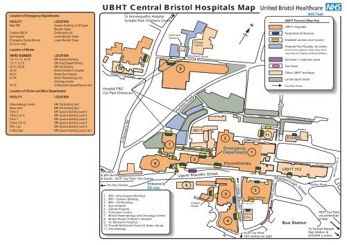
UBHT Central Bristol Hospitals Map - United Bristol Healthcare NHS ...
UBHT Central Bristol Hospitals Map - United Bristol Healthcare NHS ...
UBHT Central Bristol Hospitals Map - United Bristol Healthcare NHS ...

Create successful ePaper yourself
Turn your PDF publications into a flip-book with our unique Google optimized e-Paper software.
Location of Emergency Departments:<br />
FACILITY LOCATION<br />
Main BRI Queens Building L3 off Upper<br />
Maudlin Street<br />
Children BRCH St Michael's Hill<br />
Eye Hospital Lower Maudlin Street<br />
Emergency Dental Service<br />
Lower Maudlin Street<br />
(5-9 p.m. only)<br />
Location of Wards:<br />
WARD NUMBER LOCATION<br />
1-6, 10, 14, 16-18 BRI Queens Building<br />
7,9,11,12,15 BRI King Edward Builing<br />
20-23, 25-29 BRI Old Building<br />
30-39 <strong>Bristol</strong> Children's Hospital<br />
40-43 <strong>Bristol</strong> Eye Hospital<br />
61-64 <strong>Bristol</strong> Haematology and<br />
Oncology Centre<br />
70-78 St Michael's Hospital/Gynae Unit<br />
Location of Clinics and Main Departments<br />
FACILITY LOCATION<br />
Rheumatology Centre BRI Old Building Yard<br />
Milne clinic BRI Old Building Yard<br />
Clinic 2 BRI Queens Building Level 3<br />
Clinics 3 to 5 BRI Queens Building Level 4<br />
Clinic 7 BRI Queens Building Level 2<br />
Clinics 9 & 10 BRI Queens Building Level 4<br />
Path. Lab. BRI Queens Building Level 8<br />
X-Ray Dept BRI Queens Building Level 2 & 3<br />
<strong>UBHT</strong> <strong>Central</strong> <strong>Bristol</strong> <strong>Hospitals</strong> <strong>Map</strong><br />
Royal Fort Road<br />
Hospital P&D<br />
Car Park Entrances<br />
St Michael's Hill<br />
To Clifton<br />
& M5 North<br />
& South - NCP Car Park 100 metres<br />
To City Centre<br />
To Homoeopathic Hospital<br />
Tyndalls Park Childrens Centre<br />
Entrance to<br />
ED only<br />
Southwell<br />
House<br />
10 9<br />
1. BRI : King Edward Building<br />
2. BRI : Queens Building<br />
3. BRI : Old Building<br />
4. Eye Hospital<br />
5. Dental Hospital<br />
6. Education Centre<br />
7. <strong>Bristol</strong> Haematology and Oncology Centre<br />
8. <strong>Bristol</strong> Royal Children's Hospital<br />
9. St. Michael's Hospital<br />
10. Ronald McDonald House & Sams House<br />
11. Dermatology<br />
8<br />
7<br />
Horfield Road<br />
Southwell Street<br />
Upper Maudlin Street<br />
6<br />
Energy<br />
Centre<br />
IM+T<br />
2<br />
Chapter<br />
House<br />
2<br />
Physiotherapy<br />
Lower Maudlin Street<br />
Alfred Parade<br />
Milne<br />
Clinc<br />
N<br />
Emergency<br />
Department 1<br />
5<br />
4<br />
3<br />
Rheumatology<br />
Cottage Place<br />
11<br />
Whitson street<br />
NCP Car Park<br />
100 metres on right<br />
Montague Place<br />
Marlborough Hill<br />
One Way<br />
<strong>UBHT</strong> Precinct <strong>Map</strong> Key<br />
<strong>UBHT</strong> <strong>Hospitals</strong><br />
Pedestrian Entrances<br />
Disabled access (non brown)<br />
Hospital Pay+Display car parks<br />
(most of the adjacent roads have short<br />
stay Pay and Display parking facilities.)<br />
Set down / collection point<br />
Taxi Rank<br />
Somerset Street<br />
Other <strong>UBHT</strong> buildings<br />
Landscaped areas<br />
One Way Roads<br />
Marlborough Hill Place<br />
Estates<br />
<strong>UBHT</strong> HQ<br />
Marlborough Street<br />
Bus Station<br />
Eugene Street<br />
Dighton Street<br />
NCP Car Park<br />
via pedestrian<br />
bridge<br />
To Temple Meads<br />
Rail Station &<br />
M32/M4 London<br />
Montague Hill. S.
Principal Bus Routes<br />
1<br />
2<br />
3<br />
4<br />
5<br />
6<br />
7<br />
8<br />
9<br />
10<br />
9<br />
11<br />
Tyndalls Park Road<br />
Elmdale Road<br />
Elton Rd<br />
Woodland Road<br />
Park Row<br />
N<br />
Prince Street<br />
St Michaels Hill<br />
12<br />
The Centre<br />
Commercial Road<br />
Bus Station<br />
13<br />
St James<br />
14<br />
Barton<br />
7<br />
8 5<br />
6<br />
15<br />
Broadmead<br />
Shopping<br />
Precinct 4<br />
Old<br />
Market<br />
16<br />
Horfield Road<br />
Upper Maudlin St<br />
Colston Avenue<br />
17 1<br />
Guinea St.<br />
Redcliffe Hill<br />
L. Maudlin St<br />
Rupert Street<br />
The route of the<br />
Hospital and University<br />
shuttle bus service<br />
St Mary<br />
Redcliffe<br />
Temple Way<br />
2<br />
3<br />
Bond Street<br />
Temple Meads<br />
Rail Station<br />
Not to scale<br />
Guinea Street<br />
Te m p l e M e a d s<br />
Te m p l e Way<br />
B r o a d m e a d<br />
10 Elton Road<br />
11 Ty n d a l l s Pa r k R o a d<br />
12 St Michael's Hill<br />
13 Horfield Road<br />
Debenhams-St Ja m e s B a r ton 14 Upper Maudlin Street<br />
T h e H ay m a r ke t 15 T h e Hay m a r ke t<br />
L ower Maudlin Street<br />
Upper Maudlin Street<br />
16 Colston Ave nue<br />
17 Guinea Street<br />
Wo o d land Road<br />
Buses run regularly every 24 minutes (Mon.-Fri. only - not Bank Holidays).<br />
Bus stops are indicated in red. See the Bus Shuttle Time Table for details.<br />
U n i t e d B r i s t o l H e a l t h c a r e N H S Tr u s t<br />
Te l : 0 1 1 7 9 2 3 0 0 0 0<br />
M i n i c o m 0 1 1 7 9 3 4 9 8 6 9 w w w. u b h t . n h s . u k<br />
J u n e 2 0 0 4<br />
<strong>UBHT</strong> Location <strong>Map</strong><br />
A 3 6 9<br />
< M 5 S o u t h<br />
< P o r<br />
<<br />
T<br />
o<br />
A<br />
t i s h e a d / M 5<br />
J u n c t i o n 1 9<br />
M 5<br />
<strong>UBHT</strong> Location <strong>Map</strong> Key<br />
4<br />
<strong>UBHT</strong> main precinct<br />
<strong>Bristol</strong> General Hospital<br />
Long stay Car Park (MSCP)<br />
Park and Ride Car Parks<br />
Bus Station<br />
Rail Station<br />
M 4 9 W a l e s ><br />
J u n c t i o n 1 8<br />
Roads links to the Hospital<br />
Motorway Links<br />
R i v e<br />
M 5<br />
Park & Ride<br />
The Portway<br />
( The Haymarket is the<br />
nearest Park & Ride stop<br />
for the Hospital)<br />
r A v o n<br />
N o r t h<br />
><br />
C l i f t o n<br />
S u s p e n s i o n<br />
B r i d g e<br />
A 3 7 0<br />
Park & Ride<br />
Long Ashton<br />
< To W e s t o n - s u p e r - M a r e<br />
a n d B a r r o w H o s p i t a l<br />
><br />
A 4 0 1 8<br />
< A 3 8 To C h e d d a r<br />
To M 5 N o r t h & M 4<br />
J u n c t i o n 1 7<br />
( The Haymarket is the<br />
nearest Park & Ride stop<br />
for the Hospital)<br />
<strong>Map</strong> 3<br />
To G l o u c e s t e r ><br />
A 3 8<br />
Temple Meads<br />
Rail Station<br />
Parkway<br />
Rail Station<br />
U B H T C e n t r a l B r i s t o l H o s p i t a l s :<br />
B r i s t o l R o y a l I n f i r m a r y<br />
B r i s t o l R o y a l C h i l d r e n ' s H o s p i t a l<br />
S t M i c h a e l ' s H o s p i t a l<br />
B r i s t o l H a e m a t o l o g y & O n c o l o g y C e n t r e<br />
D e n t a l H o s p i t a l<br />
E y e H o s p i t a l<br />
Lower Guinea Street<br />
Commercial Road<br />
Guinea Street<br />
Entrance<br />
<strong>Bristol</strong> General<br />
Hospital<br />
River Avon<br />
M 3 2<br />
A 3 7<br />
Park & Ride<br />
Brislington<br />
( The Haymarket is the<br />
nearest Park & Ride stop<br />
for the Hospital)<br />
To W e l l s / Ye o v i l ><br />
J u n c t i o n 1 9<br />
/ M 4<br />
Schematic map/not to scale<br />
N<br />
M 4 L o n d o n ><br />
A v o n R i n g<br />
R o a d<br />
A 4 2 0<br />
To B a t h /<br />
C h i p p e n h a m ><br />
A 4<br />
To B a t h ><br />
& K e y n s h a m<br />
H o s p i t a l<br />
( 7 m / 1 1 k m )