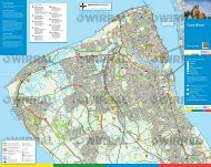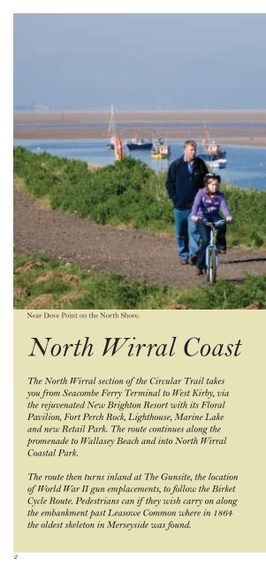
North Wirral Coast
North Wirral Coast
North Wirral Coast

Create successful ePaper yourself
Turn your PDF publications into a flip-book with our unique Google optimized e-Paper software.
Near Dove Point on the <strong>North</strong> Shore.<br />
<strong>North</strong> <strong>Wirral</strong> <strong>Coast</strong><br />
The <strong>North</strong> <strong>Wirral</strong> section of the Circular Trail takes<br />
you from Seacombe Ferry Terminal to West Kirby, via<br />
the rejuvenated New Brighton Resort with its Floral<br />
Pavilion, Fort Perch Rock, Lighthouse, Marine Lake<br />
and new Retail Park. The route continues along the<br />
promenade to Wallasey Beach and into <strong>North</strong> <strong>Wirral</strong><br />
<strong>Coast</strong>al Park.<br />
The route then turns inland at The Gunsite, the location<br />
of World War II gun emplacements, to follow the Birket<br />
Cycle Route. Pedestrians can if they wish carry on along<br />
the embankment past Leasowe Common where in 1864<br />
the oldest skeleton in Merseyside was found.<br />
2
Moreton Beach is where the world’s first passenger<br />
hovercraft service operated to Rhyl in <strong>North</strong> Wales.<br />
The route joins <strong>North</strong> Shore near Leasowe Lighthouse,<br />
which is the oldest brick built lighthouse in the country.<br />
Together horse riders, walkers and cyclists can continue<br />
past the prehistoric sunken forest and onto Meols,<br />
famous for the number of archaeological metal finds<br />
that have been made there totalling over 5,000<br />
and most of which date from 500BC to 1500AD.<br />
At King’s Gap, cyclists head inland, whilst pedestrians<br />
can continue along the foreshore or via Stanley Road to<br />
Red Rocks and onto West Kirby.<br />
3
<strong>North</strong> <strong>Wirral</strong> <strong>Coast</strong><br />
Seacombe - Tower Grounds<br />
1 Seacombe Ferry Terminal<br />
and Spaceport<br />
This is one of two sites in<br />
<strong>Wirral</strong> from which you can take<br />
a trip on the Mersey Ferry to<br />
Liverpool. Also based here is the<br />
£10 million, space-themed<br />
attraction, Spaceport which<br />
takes you on an inspirational journey through space<br />
through the several themed galleries, all of which feature<br />
a large variety of interactive hands-on exhibits and audio<br />
visual experiences.<br />
3<br />
Wallasey Town Hall<br />
Wallasey Town Hall was built<br />
to replace the old Town Hall and<br />
its foundation stone was laid into<br />
position by means of electricity,<br />
by King George V in 1914, while<br />
9,000 school children sang in the<br />
choir. Its nickname 'back-tofront'<br />
town hall arose as it was built to face the river and<br />
has a fine flight of steps leading up from the promenade.<br />
4<br />
Magazines Promenade looking towards Liverpool.
2<br />
Guinea Gap Baths<br />
Guinea Gap Baths in Seacombe<br />
is the oldest pool in <strong>Wirral</strong>.<br />
Between 1908 and 1957 no fewer<br />
than 205 world and national<br />
swimming records were achieved<br />
here. Its name is derived from<br />
the days before the promenade<br />
was built where there was a break in the riverbank known<br />
to locals as Guinea Gap. This was a popular place for<br />
anyone wishing to go for a swim as it was free from<br />
dangerous currents that lurk in the river itself.<br />
4 The Magazines area<br />
and Vale Park<br />
The area was established in the<br />
1750s when the Port of Liverpool<br />
set up the major gunpowder and<br />
weaponry storage magazines in<br />
the local sand dunes. Opened in<br />
1889, Vale Park became a public<br />
park in 1899 and was one of the best small parks in the north.<br />
With its excellent acoustics and striking appearance the<br />
bandstand is the main feature of the park.<br />
5
<strong>North</strong> <strong>Wirral</strong> <strong>Coast</strong><br />
Seacombe - Tower Grounds<br />
New Brighton<br />
Station<br />
Clockwise<br />
Anti-clockwise<br />
rake lane<br />
rowson st<br />
seabank<br />
road<br />
New<br />
Brighton<br />
Tower<br />
Grounds<br />
Tower<br />
Grounds<br />
Vale<br />
Park<br />
NCN<br />
Route 56<br />
magazine prom.<br />
4<br />
tow<br />
er<br />
prom.<br />
3<br />
war<br />
memorial<br />
NCN Route 56<br />
EGREMONT<br />
Egremont<br />
king street brighton st<br />
PROM.<br />
slipway<br />
River Mersey<br />
3<br />
2<br />
Wallasey<br />
Town Hall<br />
2<br />
borough<br />
road<br />
Seacombe<br />
NCN Route 56<br />
dock<br />
road<br />
East Float<br />
Spaceport<br />
churc h<br />
rd<br />
birkenhead road<br />
1<br />
Tunnel vent<br />
1<br />
KINGSWAY<br />
Seacombe<br />
Ferry Terminal<br />
© Crown copyright and database rights 2011. Ordnance Survey 100019803.<br />
6
Anti-clockwise:<br />
Seacombe - Tower Grounds<br />
1 - 2 From Seacombe Ferry Terminal follow the signs<br />
for New Brighton keeping the river on the right. Passing<br />
the Wallasey-Liverpool Tunnel ventilation shaft on your<br />
left and marker post for New Brighton.<br />
2 - 3 Pass Guinea Gap. Wallasey beach is on the right<br />
and Wallasey Town Hall is on the left. Continue to<br />
Egremont Ferry slipway towards New Brighton past the<br />
War memorial and then Vale Park is on your left and the<br />
Magazine Promenade is ahead. Continue onto Tower<br />
Promenade with the Tower Grounds on the left.<br />
Clockwise:<br />
Tower Grounds - Seacombe<br />
3 - 2 Having past Tower Grounds on your right, continue<br />
along the promenade passing Vale Park on the right and<br />
onto Egremont Ferry slipway and public house.<br />
2 - 1 Continue along past Wallasey Town Hall and<br />
Guinea Gap to the Seacombe Ferry Terminal.<br />
Key for map pages<br />
1<br />
1<br />
<strong>Wirral</strong> Circular Trail<br />
Walking route only<br />
Cycling route<br />
Route Numbers<br />
Places of interest<br />
National Cycle<br />
Network Route 56<br />
Motorway<br />
Roads<br />
Rail route<br />
Train Station<br />
Mersey Tunnel<br />
Ferry Service<br />
Public Footpaths<br />
Public Bridleways<br />
Visitor Centre<br />
Refreshments<br />
Pubic House<br />
Toilets<br />
Parking<br />
0 0.5<br />
1Km<br />
0 Approx. 10-15 minutes walk ½ mile<br />
7
<strong>North</strong> <strong>Wirral</strong> <strong>Coast</strong><br />
New Brighton Seafront<br />
1 New Brighton<br />
past and present<br />
New Brighton has been a seaside<br />
resort for nearly 200 years. It was<br />
created and named by Liverpool<br />
merchant, James Atherton in<br />
1830 as a seaside retreat for the<br />
gentry. In the latter half of the<br />
19th century it developed into a popular seaside resort for<br />
the surrounding industrial towns. It suffered a decline in the<br />
latter part of the last century but has been the recipient of<br />
huge investment through ‘Brand New Brighton’.<br />
3<br />
Fort Perch Rock<br />
Fort Perch Rock was completed<br />
in 1829 as a permanent<br />
fortification to protect the Port<br />
of Liverpool in times of war.<br />
Inside today lies a cornucopia of<br />
exhibits ranging from World<br />
War II aviation to naval history<br />
displays of the doomed submarine HMS Thetis, the<br />
Lusitania and the Titanic. Even Beatles and Elvis Presley<br />
memorabilia is on show inside this unusual fortress at the<br />
mouth of the Mersey Estuary.<br />
8<br />
Fort Perch Rock with Rock Lighthouse that was decommissioned in 1973.
2<br />
The Floral Pavilion<br />
In its hey-day New Brighton<br />
was the accepted rendezvous<br />
for theatre goers and with<br />
seven theatres, was rich in live<br />
entertainment. With the decline<br />
of the resort, the Floral Pavilion<br />
was the last to survive. ‘Brand<br />
New Brighton’ partly funded by The European Regional<br />
Development Fund was used to create the award-winning<br />
new Floral Pavilion that exists today.<br />
4 Tower Grounds<br />
This is where the Tower Ballroom<br />
and New Brighton Tower itself<br />
used to be. The tower was<br />
completed in 1900, 10 years after<br />
Blackpool Tower and, at 567ft<br />
(173m), was 49ft (15m) taller. It<br />
was modelled on the Eiffel Tower,<br />
attracted over 500,000 visitors a<br />
year in it's hey-day and featured<br />
one of the largest ballrooms in the world. Sadly, due to the<br />
war, the Tower became neglected and was finally dismantled<br />
in 1921.<br />
9
<strong>North</strong> <strong>Wirral</strong> <strong>Coast</strong><br />
New Brighton Seafront<br />
6<br />
Clockwise<br />
Anti-clockwise<br />
north wirral coastal park<br />
7<br />
National Cycle Network<br />
Route 56<br />
Wallasey<br />
Golf Course<br />
Liverpool Bay<br />
Wallasey Grove<br />
Road Station<br />
5<br />
Lifeguard<br />
Station<br />
harrison drive<br />
king’s par<br />
telegraph<br />
lane<br />
green lane<br />
8<br />
green lane<br />
Wallasey Village<br />
Station<br />
© Crown copyright and database rights 2011. Ordnance Survey 100019803.<br />
Anti-clockwise:<br />
Tower Grounds - <strong>North</strong> <strong>Wirral</strong> <strong>Coast</strong>al Park<br />
3 - 4 Arrive at New Brighton with the mouth of the River<br />
Mersey on your right and the Floral Pavilion on your left.<br />
Fort Perch Rock is ahead on the right.<br />
4 - 5 Follow the coastal promenade past the shops and other<br />
attractions of New Brighton and eventually past the new<br />
Neptune Development to the Pierrot roundabout and the<br />
new Swan Lake. From the roundabout, continue along the<br />
promenade keeping the King’s Parade on your left and the<br />
sea on your right to the Lifeguard Station where the cycle<br />
track becomes the coastal path.<br />
10
oad<br />
ade<br />
A554<br />
coastal drive<br />
Pierrot<br />
king’s<br />
parade<br />
New Brighton<br />
Station<br />
king’s<br />
parade<br />
marine<br />
prom.<br />
rowson st<br />
seabank<br />
Fort<br />
Perch Rock<br />
Marine Lake<br />
Tower<br />
Grounds<br />
Rock<br />
Lighthouse<br />
1<br />
New 2<br />
Brighton<br />
Tower<br />
Grounds<br />
Vale<br />
Park<br />
3<br />
4<br />
NCN<br />
Route 56<br />
tow<br />
er<br />
magazine pro<br />
4<br />
prom.<br />
3<br />
Clockwise:<br />
<strong>North</strong> <strong>Wirral</strong> <strong>Coast</strong>al Park - Tower Grounds<br />
5 - 4 From the Lifeguard Station where the coastal<br />
path becomes the cycle track, continue along the seafront<br />
promenade keeping King’s Parade on your right and the<br />
sea on your left all the way to New Brighton.<br />
4 - 3 Arrive in New Brighton, passing the new Neptune<br />
Development, with the mouth of the River Mersey and<br />
Fort Perch Rock ahead on the left. Follow the coastal<br />
promenade, past the shops and other attractions of New<br />
Brighton on your right. Eventually the promenade turns<br />
right from the seafront to the Mersey Estuary promenade<br />
and past the Floral Pavilion.<br />
The Tower Grounds will now appear on your right.<br />
11
<strong>North</strong> <strong>Wirral</strong> <strong>Coast</strong><br />
The <strong>North</strong> Shore -<br />
River Birket<br />
1<br />
<strong>North</strong> <strong>Wirral</strong> <strong>Coast</strong>al Park<br />
The <strong>North</strong> <strong>Wirral</strong> <strong>Coast</strong>al Park<br />
was established in 1986 and<br />
stretches from Derby Pool at the<br />
Wallasey end to Dove Point at<br />
Meols, a distance of about 3.5<br />
miles. The entire length of the<br />
park is bordered on its seaward<br />
side by a manmade embankment. An embankment of some<br />
description has been present on the <strong>North</strong> <strong>Wirral</strong> foreshore<br />
for 250 years.<br />
The <strong>Coast</strong>al Rangers undertake regular projects<br />
within the dunes to encourage stabilisation through<br />
vegetation management. Sand is imported into the dunes<br />
as they are cut off from their natural supply by the sea<br />
defence embankment. They once formed a natural defence<br />
against the sea and gave shelter from strong sea winds.<br />
The Park is a collection of open spaces behind the sea<br />
embankment that include the Gunsite picnic area and<br />
Leasowe Common, with numerous open grassed areas in<br />
between Leasowe Lighthouse can been seen from points<br />
within the park. The lighthouse is at the western end of<br />
Leasowe Common near to the hay meadow and the start<br />
of the River Birket cycle track.<br />
12<br />
Derby Pool cyclepath with the mouth of the River Mersey in the distance.
2<br />
The Gunsite and<br />
Leasowe Dunes<br />
The Gunsite was formerly an<br />
anti-aircraft station during the<br />
Second World War, established<br />
to protect the docks and<br />
surrounding areas from air raid.<br />
It is now a picnic area and<br />
wildlife haven for numerous butterflies and bees.<br />
The sand dunes are situated between Leasowe Bay and<br />
the Gunsite. They once formed a natural defence against<br />
the sea and gave shelter from strong winds. They are a<br />
unique and threatened habitat nationally, containing a<br />
variety of species including Sand Lizard, Burnet Moth,<br />
Marram and Lyme grasses. Look out for Kestrel and<br />
Skylark flying above your head.<br />
3 Derby Pool<br />
The Derby Pool was formerly<br />
an open air swimming pool.<br />
Some of the structure still<br />
remains as shelters. Here you<br />
can get stunning views over<br />
Liverpool Bay with glorious<br />
sunsets in the evening. There<br />
is now a pub/restaurant on-site with a mini golf course<br />
and clean beaches nearby.<br />
13
<strong>North</strong> <strong>Wirral</strong> <strong>Coast</strong><br />
The <strong>North</strong> Shore -<br />
River Birket<br />
Clockwise<br />
Anti-clockwise<br />
6<br />
The Gunsite<br />
Picnic Area<br />
Optional route for experienced road cyclists<br />
2<br />
leasowe road<br />
Liverpool Bay<br />
north wirral coastal park<br />
7<br />
telegraph<br />
lane<br />
1<br />
National Cycle Network<br />
Route 56<br />
Wallasey<br />
Golf Course<br />
green lane<br />
8<br />
A551<br />
9<br />
3<br />
5<br />
harrison drive<br />
green lane<br />
leasowe roa<br />
NCN Route 56<br />
Lifeguard<br />
Station<br />
Wallasey Grove<br />
Road Station<br />
Wallasey Village<br />
Station<br />
Leasowe<br />
River Birket<br />
10<br />
davis<br />
rd<br />
Metal bridge<br />
River Birket<br />
Bidston<br />
Golf Course<br />
M53<br />
Bidston Moss<br />
Nature Reserve<br />
© Crown copyright and database rights 2011. Ordnance Survey 100019803.<br />
Anti-clockwise:<br />
<strong>North</strong> <strong>Wirral</strong> <strong>Coast</strong>al Park - River Birket<br />
5 - 6 From the Lifeguard Station the cycle track becomes<br />
the coastal path. Continue along to the Derby Pool car park.<br />
Follow the trail along the north shore, cyclists on cyclepath<br />
and walkers alongside.<br />
6 At this point the route turns inland. (Walkers have an<br />
option to walk along the concrete track of the sea defence<br />
wall because of the current by-law prohibiting cycling.)<br />
Leasowe Lighthouse can be seen in the distance ahead.<br />
J1<br />
14
7 - 8 From the north shore, continue along the track. Care<br />
needs to be taken because this is a shared use bridleway with<br />
motor vehicles accessing the car parks. Follow the track left<br />
into Green Lane and after 200yds turn right into Telegraph<br />
Lane. National Cycle Network Route 56 continues straight on<br />
into central <strong>Wirral</strong>.<br />
8 - 9 At the main Leasowe Rd, the route continues across<br />
the road to the right of the garage. Take care crossing this<br />
busy dual carriageway. You may wish to cross this road at the<br />
pelican crossing about 200yds left or at the roundabout 100yds<br />
to the right. Enter the playing fields area leaving the garage<br />
and houses on your left, continue across the playing fields.<br />
Before the houses, turn left across the field with the houses<br />
on the right until you get to the raised embankment.<br />
9 - 10 Turn right onto the raised embankment with the<br />
river on the left and the houses on your right. Follow this<br />
grass path past the access path to the Golf Club on the left.<br />
The path turns right to run alongside the main River Birket<br />
on your left. Continue to the metal bridge where you turn left<br />
and then immediately right.<br />
Clockwise:<br />
River Birket - <strong>North</strong> <strong>Wirral</strong> <strong>Coast</strong>al Park<br />
10 - 9 From the metal bridge, follow the grass path around<br />
to the left, keeping the river on your right. Past the path to<br />
the Golf Club on your right, and continue along until the<br />
embankment reaches the end of the line of houses.<br />
9 - 8 Turn left to go across the playing field to the surfaced<br />
path. Turn right onto this path which leads out to Leasowe Rd.<br />
8 - 7 The route now follows Telegraph Lane that is<br />
diagonally right across the road. Take care crossing the busy<br />
dual carriageway. Consider using the pelican crossing or<br />
roundabout nearby. Follow this bridleway to the end, where<br />
you turn left, the NCN Route 56 joins the trail from central<br />
<strong>Wirral</strong> from your right. After 200yds turn right with the<br />
Gunsite car park now on your left.<br />
7 - 6 Take care along this track because it is a shared use<br />
route with motor vehicles accessing the <strong>North</strong> <strong>Wirral</strong> <strong>Coast</strong>al<br />
Park car parks. Continue along the track until you reach the<br />
sea defence wall.<br />
6 - 5 Turn right and follow the trail along the north shore,<br />
cyclists on cyclepath and walkers alongside. When you get to<br />
the Derby Pool car park, continue along in front of the car<br />
park on the coastal path past the Lifeguard Station and along<br />
the seafront promenade to New Brighton.<br />
15
<strong>North</strong> <strong>Wirral</strong> <strong>Coast</strong><br />
Leasowe Lighthouse -<br />
River Birket<br />
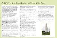
1 Leasowe Lighthouse<br />
Built in 1763 by the Mersey<br />
Docks and Harbour Board,<br />
Leasowe Lighthouse is the oldest<br />
brick built lighthouse in Britain<br />
and possibly the first building of<br />
its kind in the world to use cavity<br />
walls for insulation. It stands<br />
101ft (27m) tall on Leasowe Common. It was one of four<br />
lights on the <strong>North</strong> <strong>Wirral</strong> Foreshore used to guide ships into<br />
the entrance to the Rock Channel and the Port of Liverpool.<br />
Now a site of public interest, and a Grade II Listed<br />
monument, the Lighthouse features guided tours and special<br />
events with displays about Leasowe Lighthouse, the <strong>North</strong><br />
<strong>Wirral</strong> <strong>Coast</strong>al Park and the <strong>Wirral</strong> <strong>Coast</strong>line.<br />
3<br />
River Birket<br />
Most small rivers on <strong>North</strong><br />
<strong>Wirral</strong> flow into The Birket,<br />
the river from which Birkenhead<br />
takes its name. The Birket<br />
flows from near West Kirby to<br />
Birkenhead docks, much of the<br />
surrounding is reclaimed marsh.<br />
This area provides a rich habitat corridor for animals and<br />
birds. Look out for herons and ducks along the trail.<br />
16<br />
The bridleway track from the north shore to Leasowe Lighthouse.
2 Leasowe Castle<br />
Leasowe Castle was built by<br />
Ferdinando Stanley, 5th Earl<br />
of Derby around 1593, possibly<br />
as an observation platform for<br />
the Wallasey Races which took<br />
place on the sands opposite at<br />
Leasowe in the 16th and 17th<br />
centuries and which are regarded as a forerunner of the<br />
Derby races. At first the Castle consisted only of an<br />
octagonal tower. This had become disused by 1700, and<br />
it became known as ‘Mockbeggar Hall’. The term<br />
‘Mockbeggar Wharf ’ is still used for the adjoining<br />
foreshore. Leasowe Castle is now a hotel.<br />
4<br />
Leasowe Bay<br />
Leasowe Bay is a secluded area<br />
which is becoming popular<br />
with surfers and windsurfers.<br />
A boardwalk path through the<br />
dunes gives access to a hay<br />
meadow and the Gunsite picnic<br />
area, a former anti-aircraft base.<br />
17
<strong>North</strong> <strong>Wirral</strong> <strong>Coast</strong><br />
Leasowe Lighthouse -<br />
River Birket<br />
12<br />
park lane<br />
3<br />
River Birket<br />
1<br />
Leasowe<br />
Lighthouse<br />
north wirral coastal pa<br />
11<br />
leasow<br />
Clockwise<br />
Anti-clockwise<br />
pasture lane<br />
Moreton<br />
Station<br />
3<br />
© Crown copyright and database rights 2011. Ordnance Survey 100019803.<br />
Anti-clockwise:<br />
River Birket - Leasowe Lighthouse<br />
10 - 11 At the metal bridge near to Davis Rd, turn left<br />
over the bridge and then immediate right. Follow the path<br />
along until you come to Reeds Lane, where you turn right<br />
and then immediate left onto the riverside path keeping<br />
the River Birket now on your left. Continue along this<br />
path until you come to Pasture Rd, where you turn left,<br />
and then right.<br />
11 - 12 Having crossed the road and onto the track again,<br />
with the river on your left, continue across the fields and<br />
turn left to go past the lighthouse which is on your left.<br />
After the lighthouse car parks on your right, the route<br />
then turns right onto the public bridleway as the road<br />
goes left. Follow this bridleway along until it rejoins the<br />
sea defence wall.<br />
18
k<br />
e road<br />
River Birket<br />
Walkers only<br />
2<br />
reeds lane<br />
4<br />
Optional route for experienced road cyclists<br />
leasowe road<br />
The Gunsite<br />
Picnic Area<br />
Leasowe<br />
6<br />
7<br />
telegraph<br />
lane<br />
NCN Route 5<br />
A551<br />
G<br />
green<br />
8<br />
9<br />
Leasowe<br />
Station<br />
10<br />
Metal<br />
bridge<br />
davis<br />
rd<br />
River Birket<br />
Bidston<br />
Golf Course<br />
Clockwise:<br />
Leasowe Lighthouse - River Birket<br />
12 - 11 From the sea defence wall the route veers right<br />
towards the lighthouse. Eventually, you come to another<br />
track where you turn left, then go past the car parks on<br />
the left and Leasowe Lighthouse is on your right. About<br />
200yds after the lighthouse turn right onto the track that<br />
goes across the field to run alongside the River Birket.<br />
11 - 10 At the junction with Pasture Rd, cross over the<br />
road, turn left and then immediately right onto the<br />
continuation of the River Birket cycle track keeping the<br />
river on your right. Go as far as Reeds Lane, where you<br />
turn right and then immediately, left onto the River Birket<br />
cycle track, keeping the river this time on your left. Keep<br />
going until you get to the metal bridge where you turn left<br />
and then immediately right passing Davis Rd on the left.<br />
Follow this grassed track keeping the river on your right<br />
and the houses on your left.<br />
19
<strong>North</strong> <strong>Wirral</strong> <strong>Coast</strong><br />
Meols Promenade<br />
1 Meols Promenade<br />
Meols has a promenade and<br />
beach which stretches on to<br />
Hoylake and Moreton. Meols is<br />
steeped in Viking history and<br />
there is said to be a Viking Ship<br />
buried under the Railway Inn<br />
car park. It is an excellent spot<br />
to observe waders at low tide. A channel runs close to the<br />
shore here and this attracts the usual Oystercatchers and<br />
Redshank along with a good variety of other species,<br />
including Bar-tailed Godwit and Grey Plover.<br />
3<br />
Hoyle Lake<br />
Pictured here is the new model<br />
boating lake next to the New<br />
Lifeboat Station. For thousands<br />
of years, people had made use of<br />
a natural harbour called the<br />
Hoyle Lake. This gave its name<br />
in modern times to Hoylake.<br />
In the 17th century Hoyle Lake was a deep-water anchorage<br />
for vessels on passage to Chester and the River Dee ports.<br />
By the 1830s, with the silting of the Lake and the River Dee,<br />
the ships docked at Liverpool. By the end of the 19th century,<br />
the Lake had disappeared altogether to form the East Hoyle<br />
sandbank that can be seen in the distance today.<br />
20<br />
<strong>North</strong> Parade, Hoylake with Wales in the distance.
2<br />
The new Hoylake<br />
Lifeboat Station<br />
The Royal National Lifeboat<br />
Institution is the charity that<br />
saves lives at sea. Its volunteers<br />
provide a 24-hour search and<br />
rescue service around the UK<br />
and Ireland coasts. The RNLI<br />
operates over 230 lifeboat stations in the UK and Ireland.<br />
Three lifeboat stations are on or near the <strong>Wirral</strong> Circular<br />
Trail. Today the Mersey class lifeboat ‘Lady of Hilbre’ and<br />
carriage are towed by a caterpillar tracked Talus tractor which<br />
has been specifically designed to launch carriage lifeboats.<br />
4 The old Hoylake<br />
Lifeboat Station<br />
Hoylake Lifeboat station is one<br />
of the oldest on the coasts of<br />
Great Britain and Ireland. It<br />
was founded by the Mersey<br />
Docks & Harbour Board in<br />
1803 and taken over by the<br />
RNLI in 1894. For a time there was also a Lifeboat Station<br />
on Hilbre Island. This Station was closed in the 1930s.<br />
Hoylake has always had a ‘carriage launched’ lifeboat.<br />
In earlier times, the boat was pulled to the water by a team<br />
of horses. Frames for storing the harnesses can still be seen<br />
on the wall of the old boathouse which was built in1899.<br />
21
<strong>North</strong> <strong>Wirral</strong> <strong>Coast</strong><br />
Meols Promenade<br />
Liverpool Bay<br />
3<br />
Old<br />
Lifeboat<br />
Station<br />
New<br />
Lifeboat<br />
Station<br />
4<br />
north parade<br />
14<br />
2<br />
Boating<br />
Lake<br />
hoyle rd<br />
Queen’s<br />
Park<br />
Meols<br />
1<br />
scho<br />
forest<br />
15<br />
KING’S<br />
alderley rd<br />
valentia rd<br />
Hoylake<br />
Station<br />
trinity rd<br />
Hoylake<br />
manor<br />
rd<br />
Manor Road<br />
Station<br />
© Crown copyright and database rights 2011. Ordnance Survey 100019803.<br />
Anti-clockwise:<br />
<strong>North</strong> <strong>Wirral</strong> <strong>Coast</strong>al Park - King’s Gap Hoylake<br />
12 - 13 From point 12 the route returns to the north<br />
shore along to the <strong>Coast</strong>guard Station at Dove Point.<br />
13 - 14 From Dove Point the route then goes around the<br />
end of the sea defence wall and joins Meols Promenade.<br />
Follow this all the way along, keeping the sea on the right,<br />
to the new Lifeboat Station and model boating lake.<br />
14 - 15 Continue along the promenade to King’s Gap.<br />
Please note that from this point the road is one-way in the<br />
opposite direction and according to the by-law, cyclists must not<br />
exceed 10mph! (On the promenade, not the road)<br />
22
oad<br />
13<br />
HM <strong>Coast</strong>guard<br />
Station<br />
north wirral<br />
12<br />
coastal park<br />
park lane<br />
ol<br />
dovepoint<br />
laneroad<br />
Meols<br />
Station<br />
bennet’s lane<br />
park<br />
road<br />
River Birket<br />
River Birket<br />
Clockwise<br />
Anti-clockwise<br />
Clockwise:<br />
King’s Gap Hoylake - <strong>North</strong> <strong>Wirral</strong> <strong>Coast</strong>al Park<br />
15 - 14 From King’s Gap continue along the promenade<br />
to the new Lifeboat Station on the left.<br />
14 - 13 Continue on the route along the promenade<br />
which becomes Meols Parade and follow that until you get<br />
to the slipway at Bennet’s Lane and Dove Point. At this<br />
location the route turns right and then immediate left<br />
behind the sea wall. Walkers have the alternative option of<br />
remaining on the concrete track on the sea defence wall<br />
because of the current by-law prohibiting cycling.<br />
13 - 12 From Dove Point <strong>Coast</strong>guard Station continue<br />
onto the new path on the sea defence embankment. The<br />
route veers to the right away from the sea defence wall<br />
towards Leasowe Lighthouse.<br />
23
<strong>North</strong> <strong>Wirral</strong> <strong>Coast</strong><br />
Hoylake - West Kirby<br />
(Cubbins Green)<br />
1 Hilbre Islands/Red Rocks<br />
The three islands, isolated from<br />
the mainland by the tides, bring a<br />
sense of isolation and castaway feel,<br />
until the ebb tide exposes the beach<br />
again for the walk back to West<br />
Kirby and the everyday world.<br />
Red Rocks, designated as a Site of<br />
Special Scientific Interest, is an area of sand dunes and reedbeds<br />
and home to a variety plants the rarest of which is Mackay's<br />
Horsetail, which is not found in any other location in England.<br />
The area is important for recording migrant birds, and is a<br />
breeding site for Natterjack Toads, a breed common in<br />
mainland Europe, but rare in the UK.<br />
3<br />
King’s Gap<br />
The King’s Gap was so called<br />
because in 1690, Prince William<br />
of Orange joined his ships at the<br />
Hoyle Lake and set sail for<br />
Ireland with his fleet from these<br />
shores for his meeting with King<br />
James. His 10,000 strong army<br />
was victorious in the Battle of the Boyne.<br />
24<br />
Walking out to Hilbre Island at low tide.
2<br />
The Marine Lake<br />
One of the largest man-made<br />
lakes in the UK, it is 52 acres<br />
in size, 5ft deep and totally<br />
enclosed.<br />
The Lake is home to the<br />
<strong>Wirral</strong> Sailing School, which<br />
offers courses in sailing,<br />
windsurfing and canoeing, making it the ideal place to<br />
indulge your adventurous side. The less energetic can also<br />
enjoy the Marine Lake by taking a leisurely stroll around<br />
the lake edge path. At low tide there is a large stretch of<br />
beach from West Kirby to Red Rocks.<br />
4 The Royal Liverpool<br />
Golf Club<br />
Founded in 1869, Hoylake, as it<br />
is called by those in the know,<br />
has a long and illustrious history<br />
of playing host to the British<br />
Open and has now hosted eleven,<br />
its first in 1897. The Open is set<br />
to return to The Royal Liverpool Golf Club in 2014.<br />
25
<strong>North</strong> <strong>Wirral</strong> <strong>Coast</strong><br />
Hoylake - West Kirby<br />
(Cubbins Green)<br />
M<br />
Irish Sea/<br />
Liverpool Bay<br />
Walkers only<br />
stanley rd<br />
4<br />
15<br />
KING’S<br />
3<br />
valentia rd<br />
ey rd<br />
Hoylake<br />
Hoylake<br />
Station<br />
1<br />
Hilbre<br />
Island<br />
Royal Liverpool<br />
Golf Course<br />
Hoylake<br />
Municipal<br />
Golf Course<br />
Walkers only<br />
River Dee<br />
Sailing<br />
Club<br />
16<br />
West Kirb y Station<br />
orrysdale<br />
rd<br />
Morrisons<br />
greenbank rd<br />
jubilee<br />
dr.<br />
brighton<br />
ave.<br />
West<br />
Kirby<br />
Concourse<br />
Ashton<br />
Park<br />
17<br />
Grange<br />
Hill<br />
grange rd<br />
bridge<br />
war<br />
memorial<br />
2<br />
Marine<br />
Lake<br />
church rd<br />
Walkers only<br />
Clockwise<br />
Anti-clockwise<br />
m acdona<br />
dr.<br />
Cubbins<br />
Green<br />
18<br />
melloncroft<br />
drive<br />
Caldy<br />
Hill<br />
© Crown copyright and database rights 2011. Ordnance Survey 100019803.<br />
26
Anti-clockwise:<br />
Hoylake - West Kirby (Cubbins Green)<br />
15 From the promenade at King’s Gap turn left. There is<br />
the alternative option for walkers to remain on the beach<br />
and follow the coastline around to West Kirby. This should<br />
be possible at anytime other than at very high tides.<br />
Unless you take the beach route, continue into King’s Gap<br />
and go along to the junction of Stanley Rd. At this point,<br />
walkers and cyclists have separate routes.<br />
15 - 18<br />
Walkers: Having turned right into Stanley Rd from King’s<br />
Gap continue along to the end keeping the Royal Liverpool<br />
Golf Club on the left. At the end of Stanley Rd turn left<br />
onto the beach and follow the beach path. Keep the sand<br />
dunes on your left all the way to West Kirby promenade.<br />
At the end of Dee Lane, in front of Morrisons car park, the<br />
information board at this location gives details of suitable<br />
times to walk to Hilbre Island. There is the Sailing Club<br />
and Marine Lake to the right, and at this location walkers<br />
have 3 options.<br />
Option 1: Turn left into Dee Lane passing Morrisons on<br />
the right. At the end of Dee Lane turn right into Grange<br />
Rd, keeping West Kirby railway station and the Concourse<br />
on the left. The start of the <strong>Wirral</strong> Way is on the right.<br />
Option 2: Continue along the promenade with the Marine<br />
Lake on the right all the way to the end. When you get to<br />
the West Kirby Sailing Club turn left then right, into<br />
Macdona Drive. Follow this along to Cubbins Green.<br />
The route continues across the grassed area and you are<br />
able to join the <strong>Wirral</strong> Way at two locations on your left.<br />
Option 3: Turn right at the end of Dee Lane and walk<br />
around the Marine Lake path where it joins the West<br />
Kirby Sailing Club, the instructions are as Option 2.<br />
Opposite the Cubbins Green access to the <strong>Wirral</strong> Way is<br />
Melloncroft Drive that leads straight up to the public<br />
footpaths of Caldy Hill.<br />
27
<strong>North</strong> <strong>Wirral</strong> <strong>Coast</strong><br />
Hoylake - West Kirby<br />
(Cubbins Green)<br />
15 - 18<br />
Cyclists: Continue straight on from King’s Gap over the<br />
roundabout and straight over the level crossing next to<br />
Hoylake station. Take the turn immediately right onto the<br />
cycle track that runs adjacent to the railway. At the end of this<br />
cycle track turn left into Greenbank Rd, then immediately<br />
right into Jubilee Drive and then fork right into Brighton<br />
Avenue. Follow the paths between the houses until they exit<br />
onto the open grassed area and then turn right and left into<br />
Orrysdale Rd. Follow this road past the petrol station on the<br />
left and West Kirby Concourse on the right. The start of the<br />
<strong>Wirral</strong> Way is opposite the end of Orrysdale Rd. Continue<br />
along the <strong>Wirral</strong> Way to Cubbins Green.<br />
Clockwise:<br />
West Kirby (Cubbins Green) - Hoylake<br />
18 - 15<br />
As walkers and cyclists approach West Kirby from<br />
Thurstaston, walkers are presented with 2 options.<br />
Option 1: When on the <strong>Wirral</strong> Way, you can turn left<br />
onto Cubbins Green at two locations. Follow this grassed<br />
area along the cliff top to the road. This is Macdona Drive,<br />
which you should follow to the end, and turn left up to the<br />
start of the West Kirby promenade with the Sailing Club<br />
on the left.<br />
From this point you can choose whether to walk around<br />
the Marine Lake, or turn right and follow the promenade<br />
along, keeping the Marine Lake on your left.<br />
The Marine Lake path and the promenade meet up at the<br />
junction with Dee Lane in front of Morrisons car park.<br />
Option 2: Walkers can remain on the <strong>Wirral</strong> Way to its<br />
end where you will need to turn left into Grange Rd<br />
leaving West Kirby Concourse and the railway station on<br />
your right. Pass both these locations and turn left into<br />
Dee Lane. Follow this road keeping Morrisons to your<br />
left until you get to the seafront.<br />
28
With Morrisons behind you, turn right onto the beach,<br />
leaving the Marine Lake behind you. The information<br />
board at this location gives suitable times to walk out<br />
to Hilbre Island.<br />
Follow the beach path, passing the sand dunes on your<br />
right, until you get to the rocky area locally known as Red<br />
Rocks. At the end of Stanley Rd where you can turn right,<br />
follow Stanley Rd to the end keeping the Royal Liverpool<br />
Golf Club on your right. At the end of Stanley Rd turn left<br />
into King’s Gap to the seafront promenade.<br />
It is possible to remain on the beach and go around from<br />
Red Rocks to Hoylake Promenade at times other than<br />
when there is a very high tide.<br />
18 - 15<br />
Cyclists: From Cubbins Green, continue to the end of<br />
the <strong>Wirral</strong> Way and go straight over into Orrysdale Rd<br />
keeping West Kirby Concourse on your left and the<br />
petrol station on your right. At the end of Orrysdale Rd,<br />
turn right and immediate left onto the track behind the<br />
houses and follow this through to Jubilee Drive, and then<br />
left into Greenbank Rd. Turn immediately right on the<br />
bend onto the cycle track which takes you all the way to<br />
Hoylake railway station, where you turn left over the level<br />
crossing. Continue over the roundabout into King’s Gap<br />
and straight down to the seafront promenade.<br />
Hoylake to West Kirby cycle track.<br />
29