suds modelling for surface water management - SUDSnet
suds modelling for surface water management - SUDSnet
suds modelling for surface water management - SUDSnet
Create successful ePaper yourself
Turn your PDF publications into a flip-book with our unique Google optimized e-Paper software.
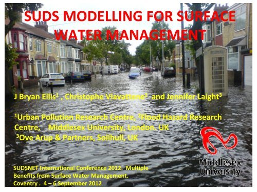
SUDS MODELLING FOR SURFACE<br />
WATER MANAGEMENT<br />
J Bryan Ellis 1 , Christophe Viavattene 2 and Jennifer Laight 3<br />
1<br />
Urban Pollution Research Centre, 2 Flood Hazard Research<br />
Centre, Middlesex University, London. UK<br />
3<br />
Ove Arup & Partners, Solihull, UK<br />
SUDSNET International Conference 2012. Multiple<br />
Benefits from Surface Water Management.<br />
Coventry . 4 –6 September 2012
33% of urban flooding<br />
during extreme storm<br />
events due to pluvial<br />
overland <strong>surface</strong> flows<br />
Local Authorities now<br />
responsible <strong>for</strong> <strong>surface</strong> <strong>water</strong><br />
<strong>management</strong> and SWMPs<br />
Future climate<br />
change and new<br />
developments will<br />
exacerbate the<br />
pluvial flooding<br />
problem
TOOLS TO IDENTIFY<br />
CRITICAL DRAINAGE AREAS<br />
AND MANAGE THE FLOOD<br />
RISK<br />
• where flooding will occur;<br />
distribution and flow paths,<br />
depths. velocities etc<br />
• opportunities <strong>for</strong> mitigating<br />
SuDS measures<br />
• improved public/stakeholder<br />
engagement<br />
• assist <strong>for</strong>ward emergency<br />
planning
Identifying Critical Drainage Areas:<br />
• identify “hotspot “ flooding during extreme<br />
storm events<br />
• quantify depth and spatial distribution of<br />
flooding<br />
• identify flood flow paths<br />
• Identify appropriate temporary storage,<br />
attenuation and treatment facilities
1D/2D COUPLED MODELLING FOR<br />
SURFACE PLUVIAL FLOODING<br />
Flow Path<br />
2D Surface<br />
Flow<br />
Manhole<br />
Manhole<br />
1D<br />
Sewer<br />
Flow<br />
SEWER<br />
Identifies and quantifies flood depths<br />
and flow paths during extreme storm<br />
events
Exceedance<br />
Overland flow<br />
Surface<br />
surcharge<br />
Surface <strong>water</strong> sewer<br />
EXIT<br />
OVERFLOW<br />
S<br />
Surface<br />
depression<br />
“pond”<br />
Exit point from<br />
0.5m raster cell<br />
cascade<br />
Surface flooding depths and<br />
flowpath delineation<br />
algorithm follows the lowest<br />
exit point from each DTM<br />
cell i.e rolling ball technique
Shelton<br />
HEN LANE<br />
CATCHMENT<br />
COVENTRY<br />
90ha; 30%<br />
Impervious<br />
Bridge<br />
Hen
PREDICTED FLOW DISTRIBUTION AND EXCEEDANCE<br />
OVERFLOWS FOR AN EXTREME EVENT<br />
Based on 1D Hydraulic<br />
Modelling e.g STORM,<br />
InfoWorks CS etc
2D DATA INPUT TO CREATE DIGITAL<br />
TERRAIN/ELEVATION MODEL (DTM/DEM)<br />
Need topographic background <strong>for</strong> developing the 2D<br />
<strong>surface</strong> area with high vertical and spatial resolution<br />
e.g ± 2/3cm vertical and 0.5m raster cell<br />
• detailed large‐scale micro‐topographic map (with<br />
rein<strong>for</strong>cing “groundtruth” survey)<br />
• aerial/satellite images (including Google Earth and<br />
Street Views)<br />
• LiDAR survey (aerial or ground mobile)<br />
Need <strong>for</strong> the selected topographic survey to be georeferenced
Micro-topographic DEM<br />
HEN LANE CATCHMENT.<br />
COVENTRY Raster Cell 0.5m
ARUP mobile terrestrial LiDAR<br />
EA unfiltered aerial LiDAR<br />
EA filtered aerial LiDAR
COventryResults
MU2<br />
WHAT SUDS DRAINAGE<br />
CONTROLS AND WHERE TO<br />
LOCATE THEM????<br />
SUDSLOC model
Slide 17<br />
MU2<br />
To be changed with new results<br />
Middlesex University, 12/05/2011
GIS INTERFACE<br />
SUDSLOC<br />
USER‐FRIENDLY INTERFACE<br />
•Is a Geographic In<strong>for</strong>mation Decision System Support tool<br />
•Provides support <strong>for</strong> the identification and location of appropriate SUDS<br />
at urban scale<br />
•Supports the integration of data (quantitative and qualitative) from a<br />
variety of sources to enable the investigation of the potential benefits of<br />
SUDS<br />
•Is designed to communicate with storm runoff <strong>modelling</strong> approach
GIS sewer network GIS Landuse SUDS MCA Matrix<br />
SUDS<br />
‐ Storm event rainfall profiles<br />
‐ Landuse type and runoff coefficients<br />
Decision<br />
‐ Surface and soil type/character<br />
Support<br />
‐ Ground<strong>water</strong> profiles<br />
‐ 2D DEM micro‐topography SUDSLOC<br />
• 2D Surface flood maps<br />
• Flood damage costs<br />
• SUDS types and location<br />
• SUDS volume reduction<br />
• SUDS pollutant per<strong>for</strong>mance<br />
GIS DECISION<br />
SUPPORT<br />
FRAMEWORK<br />
MANAGER<br />
‐ SUDS characteristics<br />
‐ Site criteria<br />
‐ MCA Indicators and<br />
Benchmarking<br />
‐ Pollutant removal<br />
potentials (UoP)<br />
SUDS<br />
Catalogue ,<br />
Costings and<br />
Photographs<br />
External Inputs e.g<br />
STORM<br />
InfoWorksCS<br />
FloodArea 2D<br />
EcoSWM<br />
Depth‐damage<br />
curves
SUDS Assessment Components<br />
• Site Criteria<br />
Land use, soil type, slope, depth to ground<strong>water</strong>, drainage area, presence<br />
of ‘flat roofs’<br />
Scale unit : road, car park, building, pavement etc<br />
• SUDS pollutant removal potential (Ranking)<br />
Pollutant (TSS, BOD, COD, Nitrates, Phosphates, Cd , Cu,...)<br />
Unit Operating Processes (UoP); Removal Process considered (adsorption,<br />
settling, microbial degradation, filtration, plant uptake, volatilisation and<br />
photolysis)<br />
• Multi‐Criteria Comparator (Ranking)<br />
Technical, environmental, economic, operation and maintenance, social<br />
and legal criteria<br />
• Catalogue of in<strong>for</strong>mation<br />
SUDS types/photographs, design specifications, operational<br />
requirements, costings, case examples and reference listings
Interactive Map functionalities<br />
Potential Areas<br />
Site‐by‐site assessment<br />
Add a SUDS and export<br />
Flow destination
SUDSLOC: INSERTION OF<br />
INFILTRATION BASINS<br />
(Hen Lane, Coventry)
Roundabout Sewer Node<br />
FLOW<br />
OVERFLOW
COMPARISON BETWEEN PREDICTED FLOW<br />
DISTRIBUTIONS WITH AND WITHOUT SUDS INSTALLED<br />
A total decrease from 1726 m 3 to 1226 m 3 (30%)
CONCLUSIONS<br />
• GIS‐based 1D‐2D coupled <strong>modelling</strong> provides appropriate<br />
methodological approach <strong>for</strong> identifying <strong>surface</strong> <strong>water</strong> flood risk<br />
• requires appropriate LiDAR micro‐topographic input at detailed<br />
spatial and vertical resolution; 0.5m grid cell and ±2 ‐ 3cm vertical<br />
resolution needed <strong>for</strong> satisfactory definition of flood flow paths,<br />
depths and velocities<br />
• coupled SUDSLOC model selects and locates appropriate mitigating<br />
SUDS control devices and quantifies flow benefits<br />
• coupled <strong>modelling</strong> methodology offers flexible tool <strong>for</strong> mapping<br />
urban pluvial flooding, choosing mitigating control options together<br />
with flexible public communication capability and capability <strong>for</strong><br />
emergency planning


