

Bulletin 70. Caves of New Jersey, 1976 - State of New Jersey
Bulletin 70. Caves of New Jersey, 1976 - State of New Jersey
Bulletin 70. Caves of New Jersey, 1976 - State of New Jersey

You also want an ePaper? Increase the reach of your titles
YUMPU automatically turns print PDFs into web optimized ePapers that Google loves.
26<br />
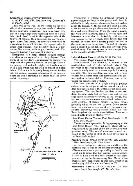
Kerreganot-WormscrewCaveSystem Wormscrew is entered by dropping through a<br />
41°lO.8'N;74°32.3'W, 500, Hamburg Quadrangle, narrow fissure set back in the quarry wall. Rope is<br />
C, Playboy Club advisable to help descend the twenty-foot pit under-<br />
These two caves (Fig. 18) are located on the west neath the fissure. At the far end <strong>of</strong> a short, passage,<br />
side <strong>of</strong> the limestone quarry just north <strong>of</strong> McAfee. at the bottom <strong>of</strong> the pit, there are a few small stalac-<br />
Before quarrying operations, they may have been tites and some flowstone. From the same passage,<br />
part <strong>of</strong> a single large cave extending as far as a small the wormscrew crawlway leads <strong>of</strong>f to the right and<br />
hole (Arch Ro<strong>of</strong> Cave) in the opposite side <strong>of</strong> the intersects a room that is blocked by both ends. A<br />
quarry. At present, their entrances are only ten feet side passage to the left leads down twenty-five feet<br />
apart; a few feet inside, the caves are connected by through an <strong>of</strong>fset into a fissure parallel to and at<br />
a crawlway too small to enter. Kerreganot, with its the same angle as Kerreganot. The end <strong>of</strong> this passingle<br />
long passage, was probably once a water- sage is blocked by similar fill that also is being slowly<br />
course; Wormscrew, with its pit, fissures, and <strong>of</strong>fset washed away. The cave system is near a major fault<br />
passages, has had a more complex history, in the Franklin ]_larble. 3a40,41,44,45<br />
Kerreganot is a long, almost straight passage<br />
that dips at an angle <strong>of</strong> about forty degrees. Two- LakeMohawkCave41°OO.4'N;74°41+l'W, 780,<br />
thirds <strong>of</strong> the way down it is necessary to crawl over a <strong>New</strong>tonEast Quadrangle, S, E. Clause<br />
large rock that partially blocks the passage. Most <strong>of</strong> Lake Mohawk Cave (Plate 6) is located at the<br />
thepassageis<strong>of</strong>walkableheight, but it ends ahrupt- southwestern end <strong>of</strong> Lake Mohawk, about fifty<br />
ly in a plug which was reported to consist <strong>of</strong> glacial feet west <strong>of</strong> the road running along the lake shore.<br />
debris. This material is slowly being washed further It was formerly used as a water supply for nearby<br />
into the system, exposing extensions <strong>of</strong> the passage, cottages. The ten-foot-deep entrance pit is now<br />
There are some attractive helictites near the lower covered by a cinder block and cement shelter to proend<br />
<strong>of</strong> the passage, tect against curious children. However, now the entrance<br />
has been blocked with fill.<br />
, Tile cave consists <strong>of</strong> a single straight passage<br />
L,_'_e" ,__ ,,_ *' enterednearitsmidpoint. ing system. The lake behind Atthebase<strong>of</strong>thepitisa<br />
the dam is two feet<br />
® deep, but after sixty feet the floor rises and the passage<br />
becomes a muddy crawlway to the far end. This<br />
__'' I*f.___ I' dam sectionandcontains the remains numerous <strong>of</strong> the water-filled storagepotholes and pump-<br />
and<br />
J _ EMTmA/CCE tq<br />
, _2_.".'..'...E.. *_ \ other evidence <strong>of</strong> stream erosion, in some places<br />
, _ ..." -" gleaming white calcite can be seen. Down stream<br />
stricted crawlways which extend about 100 feet.<br />
_z,/_/_ ._w_. _ k from Total thedam length <strong>of</strong> are the cave anumber is about<strong>of</strong> 360 dry feet. butquiteeon-<br />
The cave is<br />
"**"'M_,]'-:"'"'" formed in the Franklin Marble. 42.s2.65<br />
",,',, • Lime Crest <strong>Caves</strong> <strong>New</strong>ton East Quadrangle, S, D,<br />
I, _, I[_ YR&II CIE<br />
"' " - " " \ Lime Crest Quarry<br />
" if :///<br />
-_ long, located at the north end <strong>of</strong> the quarry, has been<br />
"_ o D Dime TwoCrest cavesQuarry. were opened The up fist during cave, quarrying about 200 at feet the<br />
caw , , , quarried away. The second cave was opened and<br />
closed in the winter <strong>of</strong> 1963-64. Both caves were in<br />
the Franklin Marble. 69<br />
WORM|CREW _t_a t _<br />
¢'- Moody's Rock 41°O1.5'N;74°46.7'W, 600, <strong>New</strong>ton<br />
West Quadrangle, PR, Tom Inslee<br />
According to legend, this large rock shelter on the<br />
,


