

Bulletin 70. Caves of New Jersey, 1976 - State of New Jersey
Bulletin 70. Caves of New Jersey, 1976 - State of New Jersey
Bulletin 70. Caves of New Jersey, 1976 - State of New Jersey

You also want an ePaper? Increase the reach of your titles
YUMPU automatically turns print PDFs into web optimized ePapers that Google loves.
34<br />
Sinking Stream (Iliff's Pond) <strong>New</strong>ton East Quad- depth <strong>of</strong> 15 feet to a vertical fissure; this led down 15<br />
rangle feet to a room about ten feet square. There is a low<br />
On a dirt road, half a mile west <strong>of</strong> l]iff's Pond there water course on one side <strong>of</strong> the room; the passage is<br />
is a stream which flows into a small hill. The en- blocked by a lens <strong>of</strong> chert after 20 feet. The cave is<br />
trance to the cave is blocked by loose rock. It is in the in the Epler Formation. 4.42<br />
Epler Formation. Devil's Kitchen Hi 40 °57.8'N;75 °55.2'W, 640, Blairstown<br />
Quadrangle<br />
WARREN COUNTY .,<br />
Bear Cave 40°59.3'N;74°59.1'W, 420, Blairstown "<br />
Quadrangle<br />
tenths <strong>of</strong> a mite north <strong>of</strong> its intersection with Route<br />
94Bear west Cave <strong>of</strong> Blalrstown. is locatedTheonentrance Bear Cave to thisRoad, cave two is a<br />
®<br />
tall crack clearly visible in the cliff to the west. A N f_ c<br />
short distance inside, the floor climbs rather steeply _" -_"_<br />
to a cross passage at the back. The sharp turn and _ __j.<br />
inadequate space make it impossible to enter this<br />
passage. The ceiling and upper walls to the rear <strong>of</strong><br />
the cave are covered with cave crickets. The cave is<br />
in the Epler Formation. 3°,39 _.<br />
Betsey Cave 40 56.4N;74 53.6 W, 600, Blalrstown<br />
Quadrangle, PR, Y. Koban<br />
Thisis asmallcave near Waterfield Cave, amile t "''_j ( 2_'_.r_'--Tx, I ® g/(_) ("'_-"<br />
south <strong>of</strong> Johnsonburg. It is in the Epler Forma- ,_/®<br />
tion.' o _ o<br />
"_'" ,.°, )--"<br />
Bone Cave 40 54 N;74 55.2 W, 350, Portland Quad- F,_2_<br />
rangle, D Oev*L'SKITCHENNO'_<br />
Three-quarters <strong>of</strong> a mile north <strong>of</strong> Delaware, in the ..............<br />
KrTrAVlmmV UOWO<br />
railroad right-<strong>of</strong>-way, a fissure was opened which _°<br />
contained many human bones. They were believed<br />
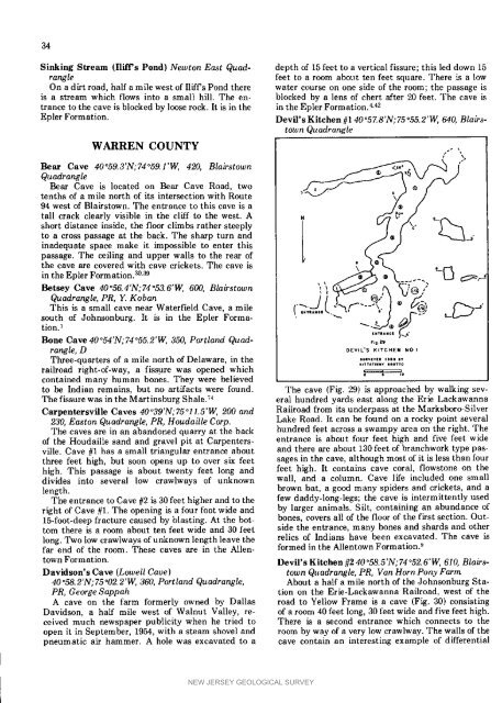
to be Indian remains, but no artifacts were found. The cave (Fig. 29) is approached by walking sev-<br />
The fissure was in the Martinsburg Shale. TM eral hundred yards east along the Erie Lackawanna<br />
Carpentersville <strong>Caves</strong> 40°39'N;75°11.5"W, 200 and Railroad from its underpass at the Marksboro-Silver<br />
230, Easton Quadrangle, PR, HoudaiUe Corp. Lake Road. It can be found on a rocky point several<br />
The caves are in an abandoned quarry at the back hundred feet across a swampy area on the right. The<br />
<strong>of</strong> the Houdaille sand and gravel pit at Carpenters- entrance is about four feet high and five feet wide<br />
ville. Cave #1 has a small triangular entrance about and there are about 130 feet <strong>of</strong> branchwork type pasthree<br />
feet high, but soon opens up to over six feet sages in the cave, although most <strong>of</strong> it is less than four<br />
high. This passage is about twenty feet long and feet high. It contains cave coral, flowstone on the<br />
divides into several low crawlways <strong>of</strong> unknown wall, and a column. Cave life included one small<br />
length, brown bat, a good many spiders and crickets, and a<br />
The entrance to Cave #2 is 30 feet higher and to the few daddy-long-legs; the cave is intermittently used<br />
right <strong>of</strong> Cave #1. The opening is a four foot wide and by larger animals. Silt, containing an abundance <strong>of</strong><br />
15-foot-deep fracture caused by blasting. At the bot- bones, covers all <strong>of</strong> the floor <strong>of</strong> the first section. Outtom<br />
there is a room about ten feet wide and 30 feet side the entrance, many bones and shards and other<br />
long. Two low crawlways <strong>of</strong> unknown length leave the relics <strong>of</strong> Indians have been excavated. The cave is<br />
far end <strong>of</strong> the room. These caves are in the Allen- formed in the Allentown Formation2<br />
town Formation. Devil's Kitchen #2 40 58.5 N; 74 52. 6 W, 610, Blaws-<br />
Davidson's Cave (Lowell Cave) town Quadrangle, PR, Van Horn Pony Farm<br />
40°58.2'N;75°O2.2'W, 360, Portland Quadrangle, About a half a mile north <strong>of</strong> the Johnsonburg Sta-<br />
PR, George Sappah tion on the Erie-Lackawanna Railroad, west <strong>of</strong> the<br />
A cave on the farm formerly owned by Dallas road to Yellow Frame is a cave {Fig. 30) consisting<br />
Davidson, a half mile west <strong>of</strong> Walnut Valley, re- <strong>of</strong> a room 40 feet long, 30 feet wide and five feet high.<br />
ceived much newspaper publicity when he tried to There is a second entrance which connects to the<br />
open it in September, 1954, with a steam shovel and room by way <strong>of</strong> a very low crawlway. The walls <strong>of</strong> the<br />
pneumatic air hammer. A hole was excavated to a cave contain an interesting example <strong>of</strong> differential<br />
NEW JERSEY GEOLOGICAL SURVEY


