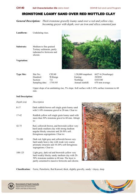
IRONSTONE LOAMY SAND OVER RED MOTTLED CLAY - asris
IRONSTONE LOAMY SAND OVER RED MOTTLED CLAY - asris
IRONSTONE LOAMY SAND OVER RED MOTTLED CLAY - asris

Create successful ePaper yourself
Turn your PDF publications into a flip-book with our unique Google optimized e-Paper software.
CH140 Soil Characterisation Site data sheet DEWNR Soil and Land Program<br />
<strong>IRONSTONE</strong> <strong>LOAMY</strong> <strong>SAND</strong> <strong>OVER</strong> <strong>RED</strong> <strong>MOTTLED</strong> <strong>CLAY</strong><br />
General Description: Thick ironstone gravelly loamy sand over a red and yellow clay,<br />
becoming greyer with depth, over an iron and silica cemented pan<br />
Landform:<br />
Undulating rises.<br />
Substrate:<br />
Medium to fine grained<br />
Tertiary sediments, partly<br />
indurated to ferricrete and<br />
silcrete.<br />
Vegetation:<br />
Type Site: Site No.: CH140 1:50,000 mapsheet: 6627-4 (Noarlunga)<br />
Hundred: Willunga Easting: 283050<br />
Section: 721 Northing: 6103180<br />
Sampling date: 17/01/05 Annual rainfall: 670 mm average<br />
Soil Description:<br />
Upper slope of an undulating rise, 5% slope. Soft surface with 2-10% surface ironstone to 60<br />
mm.<br />
Depth (cm)<br />
Description<br />
0-17 Dark reddish brown soft single grain loamy sand<br />
with 2-10% ironstone gravel to 20 mm. Clear to:<br />
17-42 Reddish yellow soft single grain loamy sand with<br />
more than 50% ironstone gravel to 60 mm. Abrupt<br />
to:<br />
42-75 Red, yellowish brown, and brownish yellow very<br />
hard sandy medium clay with strong medium<br />
angular blocky structure and 20-50% soft<br />
ferruginous segregations. Clear to:<br />
75-100 Dark red, light grey and yellowish brown very<br />
hard sandy heavy clay with weak very coarse<br />
prismatic structure and 10-20% soft ferruginous<br />
segregations. Clear to:<br />
100-125 Light grey, dark red and brownish yellow very<br />
hard weakly blocky sandy medium clay with 20-<br />
50% ironstone nodules to 60 mm. The layer is<br />
partly cemented to massive ferricrete and silcrete.<br />
Classification:<br />
Ferric, Petroferric, Red Kurosol; thick, slightly gravelly, sandy / clayey, deep
CH140 Soil Characterisation Site data sheet DEWNR Soil and Land Program<br />
Summary of Properties<br />
Drainage:<br />
Fertility:<br />
pH:<br />
Rooting depth:<br />
Well drained. Water may perch on top of the clayey subsoil for a few days following<br />
heavy or prolonged rainfall.<br />
Inherent fertility is moderately low, as indicated by the exchangeable cation data.<br />
Most surface nutrient retention capacity is attributable to organic matter. Frequent<br />
nutrient monitoring and fertilizer applications are necessary. The ironstone gravel<br />
tends to tie up phosphorus. Concentrations of all tested elements, except potassium,<br />
are satisfactory.<br />
Neutral at the surface, strongly acidic with depth.<br />
100 cm in sampling pit, but few roots below 75 cm.<br />
Barriers to root growth:<br />
Physical:<br />
Chemical:<br />
The hard clayey subsoil restricts root growth to some extent, while the underlying<br />
cemented material prevents virtually all growth.<br />
There are no apparent chemical barriers except for low nutrient status / retention<br />
capacity in the strongly acidic deep subsoil.<br />
Waterholding capacity: (Estimates for potential rootzone of grape vines)<br />
Total available: 95 mm<br />
Readily available: 45 mm<br />
Seedling emergence:<br />
Workability:<br />
Satisfactory.<br />
Satisfactory, although ironstone gravel is hard on equipment.<br />
Erosion Potential:<br />
Water:<br />
Wind:<br />
Moderate, due to the slope and moderately high soil erodibility.<br />
Moderately low.<br />
Laboratory Data<br />
Depth<br />
cm<br />
pH<br />
H 2 O<br />
pH<br />
CaC1 2<br />
CO 3<br />
%<br />
EC 1:5<br />
dS/m<br />
ECe<br />
dS/m<br />
Org.C<br />
%<br />
Avail.<br />
P<br />
mg/kg<br />
Avail.<br />
K<br />
mg/kg<br />
Cl SO 4 -S<br />
mg/kg mg/kg<br />
Boron<br />
mg/kg<br />
Trace Elements mg/kg<br />
(EDTA)<br />
Cu Fe Mn Zn<br />
Sum<br />
cations<br />
cmol<br />
(+)/kg<br />
Exchangeable Cations<br />
cmol(+)/kg<br />
Ca Mg Na K<br />
Est.<br />
ESP<br />
0-17 7.4 6.8 0 0.054 0.45 1.09 31 65 31 5.1 0.5 5.03 73 43.5 7.24 6.9 6.18 0.49 0.07 0.19 1.0<br />
17-42 6.7 6.2 0 0.022 0.36 0.17 3 19 11 4.3 0.2 0.47 56 3.47 0.46 1.6 1.20 0.28 0.06 0.03 na<br />
42-75 5.3 4.5 0 0.105 0.92 0.14 2 26 53 87.8 0.8 0.53 19 2.10 0.38 6.1 3.44 2.23 0.39 0.07 6.4<br />
75-100 4.4 3.9 0 0.159 1.08 0.15 2 33 111 39.2 0.8 0.41 29 1.64 0.18 6.6 2.32 3.57 0.60 0.09 9.1<br />
100-125 4.6 3.9 0 0.102 0.99 0.10 2 31 118 11.2 0.7 0.44 45 3.12 0.25 5.7 1.93 2.92 0.74 0.09 13.0<br />
Note:<br />
Sum of cations, in a neutral to alkaline soil, approximates the CEC (cation exchange capacity), a<br />
measure of the soil's capacity to store and release major nutrient elements.<br />
ESP (exchangeable sodium percentage) is derived by dividing the exchangeable sodium value by the CEC,<br />
in this case estimated by the sum of cations.<br />
Further information: DEWNR Soil and Land Program