LANDSCAPE ARCHAEOlOGY. EGYPT AND THE ... - CFEETK - CNRS
LANDSCAPE ARCHAEOlOGY. EGYPT AND THE ... - CFEETK - CNRS
LANDSCAPE ARCHAEOlOGY. EGYPT AND THE ... - CFEETK - CNRS
You also want an ePaper? Increase the reach of your titles
YUMPU automatically turns print PDFs into web optimized ePapers that Google loves.
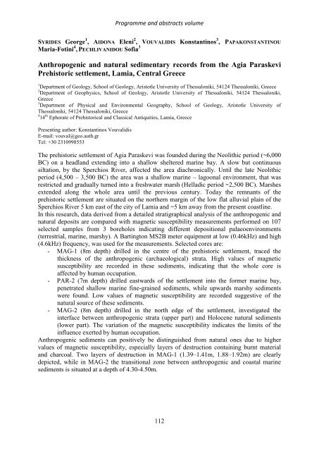
Programme and abstracts volume<br />
SYRIDES George 1 , AIDONA Eleni 2 , VOUVALIDIS Konstantinos 3 , PAPAKONSTANTINOU<br />
Maria-Fotini 4 , PECHLIVANIDOU Sofia 3<br />
Anthropogenic and natural sedimentary records from the Agia Paraskevi<br />
Prehistoric settlement, Lamia, Central Greece<br />
1 Department of Geology, School of Geology, Aristotle University of Thessaloniki, 54124 Thessaloniki, Greece<br />
2 Department of Geophysics, School of Geology, Aristotle University of Thessaloniki, 54124 Thessaloniki,<br />
Greece<br />
3 Department of Physical and Environmental Geography, School of Geology, Aristotle University of<br />
Thessaloniki, 54124 Thessaloniki, Greece<br />
4 14 th Ephorate of Prehistorical and Classical Antiquities, Lamia, Greece<br />
Presenting author: Konstantinos Vouvalidis<br />
E-mail: vouval@geo.auth.gr<br />
Tel: +30 2310998553<br />
The prehistoric settlement of Agia Paraskevi was founded during the Neolithic period (~6,000<br />
BC) on a headland extending into a shallow sheltered marine bay. A slow but continuous<br />
siltation, by the Sperchios River, affected the area diachronically. Until the late Neolithic<br />
period (4,500 – 3,500 BC) the area was a shallow marine – lagoonal environment, that was<br />
restricted and gradually turned into a freshwater marsh (Helladic period ~2,500 BC). Marshes<br />
extended along the whole area until the previous century. Today the remnants of the<br />
prehistoric settlement are situated on the northern margin of the low flat alluvial plain of the<br />
Sperchios River 5 km east of the city of Lamia and ~5 km away from the present coastline.<br />
In this research, data derived from a detailed stratigraphical analysis of the anthropogenic and<br />
natural deposits are compared with magnetic susceptibility measurements performed on 107<br />
selected samples from 3 boreholes indicating different depositional palaeoenvironments<br />
(terrestrial, marine, marshy). A Bartington MS2B meter equipment at low (0.46kHz) and high<br />
(4.6kHz) frequency, was used for the measurements. Selected cores are:<br />
- MAG-1 (8m depth) drilled in the centre of the prehistoric settlement, traced the<br />
thickness of the anthropogenic (archaeological) strata. High values of magnetic<br />
susceptibility are recorded in these sediments, indicating that the whole core is<br />
affected by human occupation.<br />
- PAR-2 (7m depth) drilled eastwards of the settlement into the former marine bay,<br />
penetrated shallow marine fine-grained sediments, while upwards marshy sediments<br />
were found. Low values of magnetic susceptibility are recorded suggestive of the<br />
natural source of these sediments.<br />
- MAG-2 (8m depth) drilled in the north edge of the settlement, investigated the<br />
interface between anthropogenic strata (upper part) and Holocene natural sediments<br />
(lower part). The variation of the magnetic susceptibility indicates the limits of the<br />
influence exerted by human occupation.<br />
Anthropogenic sediments can positively be distinguished from natural ones due to higher<br />
values of magnetic susceptibility, especially layers of destruction containing burnt material<br />
and charcoal. Two layers of destruction in MAG-1 (1.39–1.41m, 1.88–1.92m) are clearly<br />
depicted, while in MAG-2 the transitional zone between anthropogenic and coastal marine<br />
sediments is situated at a depth of 4.30-4.50m.<br />
112


