You also want an ePaper? Increase the reach of your titles
YUMPU automatically turns print PDFs into web optimized ePapers that Google loves.
The Arunachal Pradesh Gazette<br />
EXTRAORDINARY<br />
PUBLISHED BY AUTHORITY<br />
No. 235, Vol. XIX,<br />
Naharlagun, Friday, December 7, 2012 Agrahayana 16, 1934 (Saka)<br />
GOVERNMENT OF ARUNACHAL PRADESH<br />
DEPARTMENT OF TOWN PLANNING & URBAN LOCAL BODIES<br />
ITANAGAR<br />
————<br />
NOTIFICATION<br />
The 20th November, 2012<br />
No. DTP/MUN-43/2010-11/4290-01.—WHEREAS, the Government of Arunachal Pradesh <strong>in</strong> exercise<br />
of powers conferred by Sub-Section(I) of Section 4 of the Arunachal Pradesh Mu<strong>nic</strong>ipal Act, 2007 (Act No. 4 of<br />
2008) vide notification issued vide Memo No. DTP/MUN-43/2010-11 dated 24th August, 2010 had constituted<br />
Pasighat Mu<strong>nic</strong>ipal areas.<br />
AND WHEREAS, the Government of Arunachal Pradesh <strong>in</strong> exercise of powers conferred by sub-rule (I)<br />
of Rule (3) of the Arunachal Pradesh Delimitation of Ward Rules, 2010 had constituted the Mu<strong>nic</strong>ipal Wards for<br />
Pasighat Mu<strong>nic</strong>ipality vide Notification No. DTP/MUN-43/2010-11 dated 15th June, 2012, and accord<strong>in</strong>gly<br />
objections/suggestions <strong>in</strong> this regard to the proposed Mu<strong>nic</strong>ipal Wards were <strong>in</strong>vited from any <strong>in</strong>dividual or<br />
department or anybody with<strong>in</strong> a period of 30 days from the date of the issue of such notice.<br />
AND WHEREAS, 9 numbers of claims and objections were received, considered and disposed<br />
off by the Deputy Commissioner, Pasighat as <strong>in</strong>timated vide his letter No. PSG/MUN-01/12/1268 dated<br />
24th August, 2012.<br />
AND WHEREAS, the Government of Arunachal Pradesh <strong>in</strong> exercise of the powers conferred under<br />
Sub-section (I) of Section (3) of the Arunachal Pradesh Mu<strong>nic</strong>ipal Election Act, 2009 (Act No. 4 of 2009) read<br />
with sub-rule (d) of Rule 9 of the Arunachal Pradesh Mu<strong>nic</strong>ipal Delimitation of Ward Rules, 2010 hereby<br />
determ<strong>in</strong>es the limitation of Wards of the Pasighat Mu<strong>nic</strong>ipality as <strong>in</strong>dicated <strong>in</strong> the Schedule-I and II of the<br />
notification.<br />
NOW THEREFORE, the Governor of Arunachal Pradesh <strong>in</strong> pursuance to Rule 10 of the Arunachal Pradesh<br />
Mu<strong>nic</strong>ipal Delimitation of Wards Rules, 2010 hereby publishes the said order <strong>in</strong> the Arunachal Pradesh Gazette.<br />
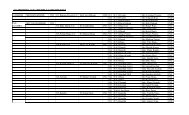
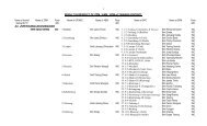
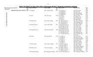
SCHEDULE-I<br />
Statement Show<strong>in</strong>g the List of Localities/Settlement with<strong>in</strong> the proposed<br />
Mu<strong>nic</strong>ipal Wards of Pasighat Mu<strong>nic</strong>ipality<br />
Town Wards Name of Sector/Localities Population<br />
(Census 2011)<br />
1 2 3 4<br />
Pasighat 1 GTC, JN College Co-operative Society Area, JN College Rural Bank, JNV 1797<br />
(East Area, Tebo Area.<br />
Siang)<br />
2 JNC campus, Kali Mandir Area, Donyi-Polo Gangg<strong>in</strong>g, RWD Colony,Women 2047<br />
Hostel, TB Hospital, AYUSH Centre, Assa Nurs<strong>in</strong>g Home, APSTS station<br />
with Colony, Central Agri. University, DC Bungalow and Upper Paglek.<br />
3 Microwave Tower Area, Forest Colony, D.Er<strong>in</strong>g M.E.School, Agam Colony, 1978<br />
SFS School, Field Publicity Colony,NHPC & Jaypee Colony.<br />
4 Doordarshan Colony, N.Er<strong>in</strong>g Complex, AIR Colony, CF Office, Post Office, 1765<br />
Industries Office Campus, UD Office^High Region-Kali Mandir Area, Maishtry<br />
Colony, Power Colony, D.Er<strong>in</strong>g High School, Power Transformer Yard.<br />
5 PHED Enquiry Office and Colony, Power House Area/PWD Div. Store and 1981<br />
Garage, WRD office, APMC Hut, Museum and Library, Buddhist Gompa,<br />
Officer’s Colony, General Hospital, Town Club Area, PWD and CWC Office.
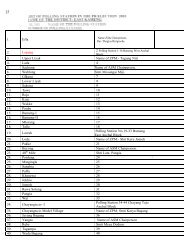
2 The Arunachal Pradesh Extraord<strong>in</strong>ary Gazette, December 7, 2012<br />
1 2 3 4<br />
Wards<br />
Name/<br />
Number<br />
6 Pasighat General Ground, Airfield-MurH<strong>in</strong>e Area, Lower Paglek, IOC Depot 1963<br />
campus, DFO’s residence, CRPF barracks, Fire Station.<br />
7 DC Office Complex, Officer’s club (Telephone Exchange, Centenary Park, 1907<br />
Veter<strong>in</strong>ary Complex, Solung Ground, Pane Spr<strong>in</strong>g Area, Naamghar and<br />
Balat Temple, APP Colony, M. Borang Oil Depot, Police Station Jail and<br />
Fishery Complex.<br />
8 Green Valley-Banskota, Ape^c Bank, Siang Guest House, Circuit House, IB, 1798<br />
Education Colony, Town M.E. School, IGJ HS School, Arshang School<br />
V campus.<br />
9 Pasighat Market Square,/Lower Banskota Along SS Mission Road, Mela 1967<br />
Ground, Backside Tasung Build<strong>in</strong>g, West Green Valley.<br />
10 Primary School Jarku, Jarku Village, Lower Muril<strong>in</strong>e, East- Lower Banskota, 2269<br />
Cemetery and SW Dump<strong>in</strong>g Ground area.<br />
11 Bus Station Colony, SBI Compound, Er<strong>in</strong>g Commercial Complex, Bazar 2047<br />
Sumo Stand, Anchal Meat Shed, S.S.Mission Colony, WRC on left Bank<br />
of Ramro Nallah, Bamboo Groove beh<strong>in</strong>d S.S. Mission.<br />
12 AIR Station, VTI Campus, Gum<strong>in</strong> Nagar, DIET and K.V. School area, FCI 1699<br />
Godown, UD Shopp<strong>in</strong>g Complex and Guest House, APST Colony and<br />
Panyang Saw Mill.<br />
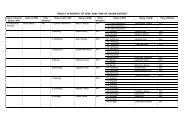
SCHEDULE - II<br />
Boundary description of Pasighat Mu<strong>nic</strong>ipal Wards<br />
Boundary DISCRIPTION OF WARDS (Name/Number)<br />
1 2 3<br />
1. North — The Northern Boundary starts from the culvert over the Tebo Stream at GTC area and it<br />
goes at 10 degree direction (approximately) up to the po<strong>in</strong>t where it reaches Siang River.<br />
Then it turns towards south-east and runs along the right bank of Siang.<br />
East<br />
— The Eastern boundary starts from the North - East corner till it reaches the Siang-Sibo<br />
Korong confluence and at 68.21° turns south-west.<br />
South — From confluence it goes south-west upstream of Sibo Korong till the new RCC bridge<br />
over Sibo Korong.<br />
West — It goes along the slope of JN College bisect<strong>in</strong>g the NH52 and meet at Tebo stream.<br />
2. North — The Northern Boundary starts from the po<strong>in</strong>t where road lead<strong>in</strong>g to JNC Upper Campus<br />
takes a sharp bend then run south along the slope meet<strong>in</strong>g ward 1 near Tebo stream and<br />
cont<strong>in</strong>ues till it meets Sibo Korong near the Bridge. At 65.12° it runs along the Sibo<br />
Korong till the Siang River confluence.<br />
East<br />
— The Eastern boundary starts from the rivers confluence till it reaches the Komlighat<br />
Jetty po<strong>in</strong>t.<br />
South — From Komlighat Jetty it goes south-west along the NH52 till Medical Charali and turns<br />
south upto Men’s Health Tra<strong>in</strong>ees Hostel road Junction and along Siang Model School<br />
street encompass<strong>in</strong>g RWD Colony and run along PLT Road upto Mirmir Charali.<br />
West — The Western boundary starts from PLT-Pasighat Balek Road junction popularly known<br />
as Mirmir Charali near Microwave Station at the south - west corner of the Township<br />
and turns at 310 degree angle towards Sibo-korong and meets Sibo-korong river<br />
cover<strong>in</strong>g the Central Donyi Polo Gangg<strong>in</strong>g. Then it runs across Sibo-Korong river <strong>in</strong><br />
cont<strong>in</strong>uity upto the South corner of JNC acquired area. Then it turns towards West - North<br />
direction along Siy<strong>in</strong>g Korong upto a distance of 3 kms cover<strong>in</strong>g JNC upper and lower<br />
campus <strong>in</strong>clud<strong>in</strong>g PHE Water Treatment Plant and College boundary pillar.<br />
3. North — It starts from PLT road junction near RWD colony along SFS school street towards<br />
NHPC colony upto Biological park 4-route junction.<br />
East<br />
— Thereupon it run southward meet<strong>in</strong>g Pasighat-Balek Road <strong>in</strong> 4-route junction popularly<br />
known as Mirmir T<strong>in</strong>ali.<br />
South — The South West boundary run straight till it aga<strong>in</strong> term<strong>in</strong>ates at Mirmir Charali<br />
West — Mirmir Charali Po<strong>in</strong>t.
The Arunachal Pradesh Extraord<strong>in</strong>ary Gazette, December 7, 2012 3<br />
1 2 3<br />
4. North — The Northern Boundary l<strong>in</strong>e starts from Biological Park Junction and goes north-east<br />
cover<strong>in</strong>g UD office, High Region Kali Mandir area, RWD colony beh<strong>in</strong>d General Hospital.<br />
East<br />
— At junction near Town Club it runs south-west cover<strong>in</strong>g Power Transformer Yard all along<br />
the road lead<strong>in</strong>g to D.Er<strong>in</strong>g HSS School and turns toward Post Office-AIR junction cover<strong>in</strong>g<br />
Sri N<strong>in</strong>ong Er<strong>in</strong>g’s (MP) residence and Doordarshan Residential Complex.<br />
South — Private plots with commercial establishment beh<strong>in</strong>d N.Er<strong>in</strong>g’s Residence and ends at<br />
Mirmir T<strong>in</strong>ali junction.<br />
West — It runs along the NHPC complex road encompass<strong>in</strong>g Forest office and Forest Colony<br />
Primary School till it meets at Biological Park Junction.<br />
5. North — The Northern Boundary l<strong>in</strong>e starts from Medical Charali junction and goes north-east<br />
along NH52 till Gandhi Middle School Junction and then goes south along NH52.<br />
East<br />
— From the po<strong>in</strong>t near Central Water Commission office cover<strong>in</strong>g Buddhist Gompa, Museum<br />
and District Library the ward boundary turns westward.<br />
South — It follows the road lead<strong>in</strong>g to Town Club cover<strong>in</strong>g DST colony, Education Colony and then<br />
along Siang Guest House Road cover<strong>in</strong>g PHED colony and PHED Enquiry Office.<br />
West — The Boundary runs parallel to BSNL office and at. AIR office along Post office road it<br />
meets Ward 4 southern boundary.<br />
6. North — The Northern Boundary l<strong>in</strong>e starts from Gandhi Middle School junction and goes<br />
north-east along PI L<strong>in</strong>e road till Komlighat Jetty.<br />
East<br />
— From Komlighat po<strong>in</strong>t the boundary goes south-east along the River Siang embankment<br />
upto a distance of 749 mtrs and then turn west near Jarku School road.<br />
South — From Jarku Primary School junction it follows the road <strong>in</strong> the manner of arc till it meets the<br />
road lead<strong>in</strong>g to dump<strong>in</strong>g ground. It runs south-west cover<strong>in</strong>g Airfield-area meet<strong>in</strong>g NH52<br />
near Banskota Mela ground.<br />
West — The western boundary straight along NH52 bisect<strong>in</strong>g IGJ HS School and School play<br />
ground upto the junction of Gandhi Middle School.<br />
7. North — It starts from 4-route junction Near AIR station cover<strong>in</strong>g SP’s Residence BSNL office and<br />
Centenary Park follows the road lead<strong>in</strong>g to Pasighat Bazar.<br />
East<br />
— It runs right along the arterial road of Bazar and cover<strong>in</strong>g Lal Bahadur Shastri School,<br />
Naamghar and Balaji Temple and then run southward beh<strong>in</strong>d Market Square and excluded<br />
WRC area of K. Borang and meet NH52 encompass<strong>in</strong>g Police station, Jail and meet<br />
Ramro Nallah.<br />
South — The boundary runs upstream along Ramro Nallah cover<strong>in</strong>g few plots of Agricultural land<br />
and bisects Ramro Nallah aga<strong>in</strong> near Fishery Office complex.<br />
West — It goes northwards cover<strong>in</strong>g Fishery pond, Mirku village Cemetery , DC office Complex<br />
and ends at AIR station road junction.<br />
8. North — It starts from Junction near Siang Guest House cover<strong>in</strong>g IB area and then follows road<br />
lead<strong>in</strong>g to IGJ HS School and meets NH52 near Museum.<br />
East<br />
— It runs with the ward boundary of Ward 6 upto the Residence of Denong Tamuk cover<strong>in</strong>g<br />
Arshang School and adjo<strong>in</strong><strong>in</strong>g commercial area.<br />
South — From the NH52 junction it covers the area of Upper Banskota/Green Valley and meets<br />
the road go<strong>in</strong>g to Bazar near Tasung Commercial Build<strong>in</strong>g.<br />
West — It goes northwards cover<strong>in</strong>g Hotel Ane, Padung Commercial Build<strong>in</strong>g, Apex Bank and<br />
meets the ward boundary near Siang Guest House.<br />
9. North — It starts from Junction near Tasung Commercial Build<strong>in</strong>g encompass<strong>in</strong>g area beh<strong>in</strong>d<br />
Market Square, West Green Valley follow<strong>in</strong>g the boundary of ward 8 till it meets NH52.<br />
East<br />
— It covers the area of Mela ground south wards and turns westwards meet<strong>in</strong>g with the road<br />
lead<strong>in</strong>g to SS Mission Road.<br />
South — Along SS Mission road it runs north ward cover<strong>in</strong>g Sadhuram Rice Mill and then along<br />
NH52 turns south-west term<strong>in</strong>at<strong>in</strong>g near the junction of M. Borang Oil Depot.<br />
West — The boundary follows Ward 7 boundary till it aga<strong>in</strong> meet near Tasung Commercial Build<strong>in</strong>g.
4 The Arunachal Pradesh Extraord<strong>in</strong>ary Gazette, December 7, 2012<br />
1 2 3<br />
10. North — It starts from Junction near Tako Dabi Residence and follows road lead<strong>in</strong>g to Jarku—<br />
Muril<strong>in</strong>e colony along the Ward 6 Boundary.<br />
East<br />
— It starts from road com<strong>in</strong>g from Jarku lead<strong>in</strong>g to Siang River and follows the flow the river<br />
approximately upto a distance of 1050 metre till the Mu<strong>nic</strong>ipal Boundary near Pilloomukh<br />
area.<br />
South — From Mu<strong>nic</strong>ipal Boundary limit near Pilloomukh area it runs South-West approximately<br />
upto a distance of 690 metre meet<strong>in</strong>g the ward boundary of Ward 11 beh<strong>in</strong>d SS Mission<br />
Bamboo groove.<br />
West — It follows Ward 11 meet<strong>in</strong>g the culvert over Pane stream and then turns south-west upto<br />
Buishi Yada motor service centre <strong>in</strong> the SS Mission Road and turns north meet<strong>in</strong>g the<br />
ward boundary of Ward 9 and follow NH- 52 term<strong>in</strong>at<strong>in</strong>g at the Start<strong>in</strong>g reference po<strong>in</strong>t<br />
near the junction of Tako Dabi residence.<br />
11. North — It starts from Junction near Apex Bank with<strong>in</strong> the Er<strong>in</strong>g Commercial Complex and runs<br />
north-east upto the road lead<strong>in</strong>g to SS Mission which it follows cover<strong>in</strong>g Maruti Workshop<br />
and some commercial plots and aga<strong>in</strong> runs north-east meet<strong>in</strong>g Pane Nallah <strong>in</strong> Muril<strong>in</strong>e.<br />
East<br />
— The boundary run along the Pane Nallah southward cover<strong>in</strong>g plantation beh<strong>in</strong>d SS<br />
Mission and rejo<strong>in</strong> the ma<strong>in</strong> road with<strong>in</strong> the SS Mission area cover<strong>in</strong>g <strong>in</strong>clud<strong>in</strong>g some<br />
agricultural field.<br />
South — It follows the natural dra<strong>in</strong>age pattern of Ramro Nallah upto the culvert over NH52 near<br />
Judicial Jail.<br />
West — From the po<strong>in</strong>t it goes northward with the NH52 where it rejo<strong>in</strong>s the Junction near Apex<br />
Bank.<br />
12. North — From the upper boundary of the <strong>in</strong>dustry area it goes towards east cover<strong>in</strong>g APST colony<br />
and meets Ramro Korong at the back side of APST colony.<br />
East<br />
— From the meet<strong>in</strong>g po<strong>in</strong>t at Ramro Korong it goes southwards and ends at south corner of<br />
All India Radio Complex at 3 mile.<br />
South — AIR Complex at 3 Mile.<br />
West — The western boundary l<strong>in</strong>e starts from South corner of All India Radio Complex at 3 mile<br />
and runs parallel to Pasighat - Jonai road (NH-52) towards Pasighat Town cover<strong>in</strong>g All<br />
India Radio Complex, VTI, Gum<strong>in</strong> Nagar, DIET, Kendriya Vidyalaya, Juvenile Remand<br />
Home, FCI Godown upto <strong>in</strong>dustry area at Sawmill.<br />
Tabom Bam, IAS<br />
Chief Secretary,<br />
Government of Arunachal Pradesh,<br />
Itanagar.<br />
————<br />
Published and pr<strong>in</strong>ted at Directorate of Pr<strong>in</strong>t<strong>in</strong>g—508/2012-DoP-250+Town Plann<strong>in</strong>g Deptt.-50-12-2012.
![FORM â 5 [See Rule 18(2)] Objection for inclusion of name. To, The ...](https://img.yumpu.com/44245868/1/190x245/form-a-5-see-rule-182-objection-for-inclusion-of-name-to-the-.jpg?quality=85)