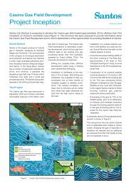
Petroleum Exploration Licence 238 Gas Utilisation Project - Santos
Petroleum Exploration Licence 238 Gas Utilisation Project - Santos
Petroleum Exploration Licence 238 Gas Utilisation Project - Santos

You also want an ePaper? Increase the reach of your titles
YUMPU automatically turns print PDFs into web optimized ePapers that Google loves.
and water management strategies are not impacted by the proposed Major <strong>Project</strong>.<br />
Limited volumes of water will be required during the construction and operation of the<br />
proposed Major <strong>Project</strong>. The water will be sourced from existing DNR licensed water bores<br />
located at Bibblewindi or from licensed water supplies in the Narrabri Township. An estimate<br />
of the volumes required for the proposed Major <strong>Project</strong> will be prepared as part of<br />
Environmental Assessment work undertaken for the project, and likely impacts of its<br />
utilisation will be addressed.<br />
6.6.1 Regional and Localised Drainage Systems<br />
The proposed Major <strong>Project</strong> is located within the western portion of the Namoi River Basin,<br />
where the regional topography is characterised by generally flat terrain and flood plains of<br />
less that 1° slope. The northern edge of the catchment is defined by Mount Kaputar and the<br />
Nandewar Ranges.<br />
The project site drainage is dominated by floodplains associated with three ephemeral<br />
tributaries of the Namoi River. The Bohena Creek is the dominant drainage line running from<br />
south to north through the entire project area and is a well defined, low sinuosity sand<br />
channel capable of accepting significant volumes of surface runoff during periods of high<br />
surface flow. Located within cleared farmland to the north of the CSG project area are the<br />
poorly defined creek channels of Bundock and Mollee Creeks.<br />
As part of Environmental Assessment activities, the GGJV will consider the relationship of the<br />
proposed Major <strong>Project</strong> with the topographic character of the project site including the likely<br />
and potential impacts on local and regional drainage features.<br />
6.6.2 Creek Crossings<br />
The flow line from Bibblewindi to the Wilga Park Power Station will cross one ephemeral<br />
creek adjacent to the Bibblewindi CSG pilot production project. The creek crossing will be<br />
carried out using trench and fill techniques at a location selected to avoid impact upon water<br />
lands. The potential for short-term biophysical impacts during construction of the flow line will<br />
be addressed during Environmental Assessment work and management plans formulated.<br />
22