TSUNAMI GLOSSARY - Disaster Pages of Dr George, PC
TSUNAMI GLOSSARY - Disaster Pages of Dr George, PC
TSUNAMI GLOSSARY - Disaster Pages of Dr George, PC

Create successful ePaper yourself
Turn your PDF publications into a flip-book with our unique Google optimized e-Paper software.
Tsunami Glossary Page 12<br />
mass and then break with a crash; (c) surging breakers<br />
(over very steep bottom gradients) which do not spill<br />
or plunge but surge up the beach face. Waves also<br />
break in deep water if they build too high while being<br />
generated by the wind, but these are usually shortcrested<br />
and are termed whitecaps.<br />
breakwater An <strong>of</strong>fshore structure such as a wall that is<br />
used to protect a harbor or beach from the force <strong>of</strong><br />
waves.<br />
HEIGHT (m)<br />
HEIGHT (m)<br />
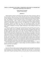
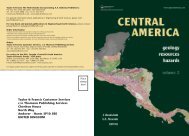
2/17/96 IRIAN JAYA <strong>TSUNAMI</strong><br />
St. No. 35<br />
0.4<br />
0.2<br />
0.0<br />
-0.2<br />
-0.4<br />
11 12 13 14 15 16 17 18<br />
PHRI<br />
0.4<br />
0.2<br />
0.0<br />
-0.2<br />
-0.4<br />
11 12 13 14 15 16 17 18<br />
TIME (hours GMT on 2/17/96)<br />
Mareograms <strong>of</strong> tsunami signals measured by an underwater gauge<br />
located 50 km outside the entrance to Tokyo Bay in about 50 m <strong>of</strong><br />
water (upper trace), and another gauge located at the shore (lower<br />
trace). The tsunami is detected on the outside gauge about 40 minutes<br />
before it reaches shore (arrows). The <strong>of</strong>fshore gauge was developed by<br />
Japan’s Port and Harbours Research Institute.<br />
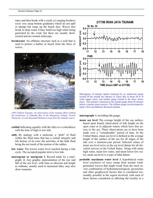
1995 Chilean Tsunami: An observation <strong>of</strong> the tsunami effects behind<br />
the breakwater at Tahauku Bay in the Marquesas Islands, French<br />
Polynesia, several thousand kilometers away from the tsunami source.<br />
cotidal Indicating equality with the tides or a coincidence<br />
with the time <strong>of</strong> high or low tide.<br />
eddy By analogy with a molecule, a “glob” <strong>of</strong> fluid<br />
within the fluid mass that has a certain integrity and<br />
life history <strong>of</strong> its own; the activities <strong>of</strong> the bulk fluid<br />
being the net result <strong>of</strong> the motion <strong>of</strong> the eddies.<br />
low water The lowest water level reached during a tide<br />
cycle. The accepted popular term is low tide.<br />
mareogram or marigram 1. Record made by a marigraph.<br />
2. Any graphic representation <strong>of</strong> the rise and<br />
fall <strong>of</strong> the sea level, with time as abscissa and height<br />
as ordinate, usually used to measured tides, may also<br />
show tsunamis.<br />
mareograph A recording tide gauge.<br />
mean sea level The average height <strong>of</strong> the sea surface,<br />
based upon hourly observation <strong>of</strong> tide height on the<br />
open coast or in adjacent waters which have free access<br />
to the sea. These observations are to have been<br />
made over a “considerable” period <strong>of</strong> time. In the<br />
United States, mean sea level is defined as the average<br />
height <strong>of</strong> the surface <strong>of</strong> the sea for all stages <strong>of</strong> the<br />
tide over a nineteen-year period. Selected values <strong>of</strong><br />
mean sea level serve as the sea level datum for all elevation<br />
surveys in the United States. Along with mean<br />
high water, mean low water, and mean lower low water,<br />
mean sea level is a type <strong>of</strong> tidal datum.<br />
probable maximum water level A hypothetical water<br />
level (exclusive <strong>of</strong> wave runup from normal windgenerated<br />
waves) that might result from the most severe<br />
combination <strong>of</strong> hydrometeorological, geoseismic<br />
and other geophysical factors that is considered reasonably<br />
possible in the region involved, with each <strong>of</strong><br />
these factors considered as affecting the locality in a