
You also want an ePaper? Increase the reach of your titles
YUMPU automatically turns print PDFs into web optimized ePapers that Google loves.
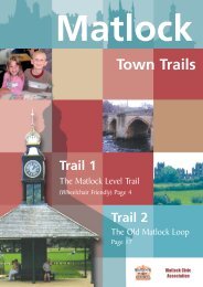
<strong>Masson</strong> <strong>Hill</strong><br />
<strong>Walk</strong><br />
Approximately 4 km<br />
Moderate <strong>Walk</strong><br />
Begins from<br />
<strong>Matlock</strong> Railway Station
MATLOCK TOWN WALKS<br />
<strong>Masson</strong> <strong>Hill</strong> walk is approx. 4 km. It can be walked in a<br />
couple of hours or so.<br />
Enjoy your walk and the beautiful views in and around<br />
<strong>Matlock</strong>.<br />
The Countryside Code<br />
There are five sections of The Countryside Code<br />
dedicated to helping members of the public respect,<br />
protect and enjoy the countryside.<br />
Be safe, plan ahead and follow any signs<br />
Leave gates and property as you find them<br />
Protect plants and animals and take<br />
your litter home<br />
Keep dogs under close control<br />
Consider other people<br />
For more information<br />
www.countrysideaccess.gov.uk
GEOFF’S<br />
SEAT<br />
SQ<br />
MASSON<br />
LEES<br />
FARM<br />
SQ<br />
Salter’s Lane<br />
250m<br />
SQ<br />
SQ<br />
SQ<br />
SQ<br />
ST JOHN THE<br />
BAPTISTS CHAPEL<br />
SQ<br />
GREENHILLS<br />
FARM<br />
MASSON<br />
MOUNT<br />
ST<br />
SQ<br />
SQ<br />
SQ<br />
HARVEYDALE<br />
QUARRY<br />
SQ<br />
HOLT<br />
QUARRY<br />
G<br />
START<br />
PEAK RAIL<br />
MATLOCK<br />
STATION<br />
River Derwent<br />
BAKEWELL<br />
A6<br />
HALL LEYSBRIDGE<br />
PARK<br />
MATLOCK<br />
335m<br />
MASSON<br />
HILL<br />
EXIT FROM<br />
MASSON MINE<br />
HEIGHTS OF<br />
ABRAHAM<br />
OLD<br />
LIMEKILN<br />
270m<br />
OLD QUARRY<br />
& SHAFTS<br />
GAP<br />
ST<br />
235m<br />
MINE SHAFT<br />
MINE<br />
ENTRANCE<br />
DISUSED<br />
RETURN PATH<br />
FROM MASSON MINE<br />
VICTORIA TOWER<br />
MASSON MINE ENTRANCE<br />
G<br />
SQ<br />
SHINING CLIFF<br />
MASSON<br />
FARM<br />
CLIFF<br />
HOUSE<br />
MATLOCK<br />
DALE<br />
CliffRoad<br />
Derby<br />
A6<br />
HIGH<br />
TOR<br />
G<br />
GRID<br />
PIC<br />
TOR<br />
N<br />
Parking<br />
Gate<br />
<strong>Walk</strong><br />
Road<br />
Wall<br />
Railway<br />
OLD<br />
MATLOCK<br />
RIBER<br />
CASTLE<br />
SQ<br />
ST<br />
Squeezer<br />
Stile<br />
River<br />
View<br />
Raised Ground
MATLOCK TOWN WALKS<br />
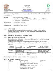
YOU CAN ENJOY THIS WALK<br />
STRAIGHT FROM<br />
MATLOCK RAILWAY STATION<br />
From the station, walk towards the town and turn right<br />
below the imposing weeping Beech Tree and walk up<br />
Snitterton Road past the Royal Bank of Scotland (RBS).<br />
Only 20 meters later turn left uphill to follow the<br />
Limestone Way signpost. Keep on uphill, crossing over<br />
the railway and passing through the farmyard of Bridge<br />
Farm to some steps in front of the farmhouse. Climb<br />
these into the field beyond. From here walk straight on<br />
through the field ignoring the path that veers off to the<br />
left. After crossing the track at the top of the field keep<br />
straight on through the next six fields. The path is<br />
reasonably easy to follow here through the squeezer<br />
stiles (including one with a dressed stone stoop). The<br />
flowers in these fields are lovely in spring and early<br />
summer – particularly when the Buttercups are out.<br />
<strong>Walk</strong> up the right hand side of the field in front of<br />
<strong>Masson</strong> Lees Farm. Cross the drive leading into the<br />
farm before crossing the small field diagonally into<br />
the far corner. Then keep on the path ahead as it<br />
rises through the next field and disappears round<br />
the corner to the right. This brings you on to a track<br />
nearly at the top of <strong>Masson</strong> <strong>Hill</strong>. Twenty five metres<br />
to your right you will see Geoff’s Seat. This has been<br />
placed here in the memory of a <strong>Matlock</strong> Solicitor<br />
who was involved in the creation of the Limestone<br />
Way – a route from Castleton to <strong>Matlock</strong> – devised<br />
by <strong>Matlock</strong> Rotary Club some years ago (an<br />
extension is a present being developed from<br />
Uppertown, Bonsall to Rocester, Staffordshire by<br />
<strong>Matlock</strong> Rotarians). Geoff’s Seat provides an<br />
excellent viewpoint with Riber Castle, <strong>Matlock</strong>,<br />
Darley Dale, Oaker <strong>Hill</strong> and Stanton Moor all visible.
The route of the walk turns left where the path reaches<br />
the track, so retrace your tracks from Geoff’s Seat. Keep<br />
on the track with <strong>Masson</strong> Lees Farm below you on your<br />
left. The track descends before starting to ascend along<br />
the bottom side of three fields. Stay on the track as it<br />
climbs. Where it bears round to the right ignore a narrow<br />
path on the left leading into the brambles and thorn<br />
trees. 25 meters later fork left along a grassy track. <strong>Walk</strong><br />
forward, 30 meters keeping to the left of a number of<br />
picnic tables slightly uphill to your right. At a gravel path<br />
at the entrance to <strong>Masson</strong> Mine walk forward into the<br />
woodland. Then zig-zag downhill towards the entrance<br />
to the Heights of Abraham.<br />
Pass through a wooden gate and then turn left as<br />
the main path turns to the right, and pass through<br />
the stile at the side of a metal gate. With High Tor<br />
now on your right walk diagonally left downhill<br />
through the trees until, after a couple of fields, you<br />
will be heading towards <strong>Masson</strong> Farm. The path<br />
stays just to the left of the farm, passing behind the<br />
farm buildings to a rather awkward step stile. Take<br />
care stretching down this to come into a smallish<br />
field. Cross this to the gap in the far side. <strong>Walk</strong> down<br />
the narrow path with the high wall on your right. This<br />
path can sometimes be rather slippery, especially as<br />
it sees very little sunlight, so take care.<br />
When you come out on to St John’s Road turn left<br />
downhill towards St John’s Chapel which is a striking<br />
and attractive building. After passing the water trough<br />
below the Chapel, take the rising path straight in front –<br />
do not continue down the road. This path is also often in<br />
the shade and can be muddy. It will bring you to a stile<br />
beside a gate after 100 meters or so. Beyond the gate try<br />
and look over the wall for another excellent view of High<br />
Tor.<br />
Continue just past the gate following the path as it<br />
bears round to the left to a dried-up dew pond, then<br />
right, then left again until you reach another<br />
squeezer stile on your right. Pass through this<br />
before crossing the next two fields along the path in<br />
front.<br />
In the third field, with a wide view of <strong>Matlock</strong> in front, you<br />
rejoin the path which brought you uphill out of <strong>Matlock</strong>.<br />
Follow this downhill to <strong>Matlock</strong>.
This walk is free of obstruction but, if you encounter any<br />
problems, please report them to <strong>Matlock</strong> <strong>Town</strong> <strong>Council</strong>.<br />
The public footpaths used on this walk are generally in<br />
good condition but there may be some mud. <strong>Walk</strong>ing<br />
boots, strong shoes or trainers are recommended.<br />
The Ordnance Survey Outdoor Leisure Map No.24 (“The<br />
Peak District White Peak Area”) can be used in<br />
conjunction with the <strong>Matlock</strong> Footpath Map.<br />
This walk begins from the town which has good public<br />
transport links.<br />
Public transport information<br />
0870 608 2 608<br />
www.traveline.org.uk<br />
Rail Times and Fare Enquiries<br />
08457 48 49 50<br />
www.nationalrail.co.uk<br />
ACKNOWLEDGEMENTS<br />
The <strong>Town</strong> <strong>Council</strong> would like to thank Charles Wildgoose<br />
for all his work on the design and explanation of the walk.<br />
<strong>Matlock</strong> <strong>Town</strong> <strong>Council</strong>, Imperial Rooms, Imperial Road,<br />
<strong>Matlock</strong> DE4 3NL tel: 01629 57488<br />
email: townclerk@matlock.gov.uk<br />
For more information about the town and things to do in<br />
<strong>Matlock</strong> visit www.matlock.gov.uk