

Foel Goch Archaeological Survey - Royal Commission on the ...
Foel Goch Archaeological Survey - Royal Commission on the ...
Foel Goch Archaeological Survey - Royal Commission on the ...

You also want an ePaper? Increase the reach of your titles
YUMPU automatically turns print PDFs into web optimized ePapers that Google loves.
UPLANDS INITIATIVE<br />
FIELD PROJECTS<br />
2011-12,<br />
<str<strong>on</strong>g>Foel</str<strong>on</strong>g> <str<strong>on</strong>g>Goch</str<strong>on</strong>g><br />
<str<strong>on</strong>g>Survey</str<strong>on</strong>g> Area,<br />
North Wales<br />
<str<strong>on</strong>g>Archaeological</str<strong>on</strong>g> <str<strong>on</strong>g>Survey</str<strong>on</strong>g><br />
Report<br />
Oxford Archaeology North<br />
February 2012<br />
RCAHMW<br />
Issue No: 2011-12/1204<br />
OA North Job No: L10362<br />
NGR: SH 947 416
Document Title: UPLANDS INITIATIVE FIELD PROJECTS 2011-12,<br />
FOEL GOCH SURVEY AREA<br />
Document Type:<br />
<str<strong>on</strong>g>Archaeological</str<strong>on</strong>g> <str<strong>on</strong>g>Survey</str<strong>on</strong>g> Report<br />
Client Name:<br />
RCAHMW<br />
Issue Number: 2011-12/1204<br />
OA Job Number: L10362<br />
Nati<strong>on</strong>al Grid Reference: SH 947 416<br />
Prepared by:<br />
Peter Schofield<br />
Positi<strong>on</strong>:<br />
Project Officer<br />
Date: February 2012<br />
Checked by: Jamie Quartermaine Signed…………………….<br />
Positi<strong>on</strong>:<br />
Senior Project Manager<br />
Date: February 2012<br />
Approved by: Alan Lupt<strong>on</strong> Signed…………………….<br />
Positi<strong>on</strong>:<br />
Operati<strong>on</strong>s Manager<br />
Date: February 2012<br />
Oxford Archaeology North © Oxford Archaeology Ltd (2012)<br />
Mill 3<br />
Janus House<br />
Moor Lane Mills<br />
Osney Mead<br />
Moor Lane<br />
Oxford<br />
Lancaster<br />
OX2 0EA<br />
LA1 1GF<br />
t: (0044) 01524 541000 t: (0044) 01865 263800<br />
f: (0044) 01524 848606 f: (0044) 01865 793496<br />
w: www.oxfordarch.co.uk<br />
e: info@oxfordarch.co.uk<br />
Oxford Archaeology Ltd is a Registered Charity No: 285627<br />
Disclaimer:<br />
This document has been prepared for <strong>the</strong> titled project or named part <strong>the</strong>reof and should not be relied up<strong>on</strong> or used for any o<strong>the</strong>r<br />
project without an independent check being carried out as to its suitability and prior written authority of Oxford Archaeology<br />
being obtained. Oxford Archaeology accepts no resp<strong>on</strong>sibility or liability for <strong>the</strong> c<strong>on</strong>sequences of this document being used for a<br />
purpose o<strong>the</strong>r than <strong>the</strong> purposes for which it was commissi<strong>on</strong>ed. Any pers<strong>on</strong>/party using or relying <strong>on</strong> <strong>the</strong> document for such<br />
o<strong>the</strong>r purposes agrees, and will by such use or reliance be taken to c<strong>on</strong>firm <strong>the</strong>ir agreement to indemnify Oxford Archaeology for<br />
all loss or damage resulting <strong>the</strong>refrom. Oxford Archaeology accepts no resp<strong>on</strong>sibility or liability for this document to any party<br />
o<strong>the</strong>r than <strong>the</strong> pers<strong>on</strong>/party by whom it was commissi<strong>on</strong>ed.
Uplands Initiative Field Projects 2011-12: <str<strong>on</strong>g>Foel</str<strong>on</strong>g> <str<strong>on</strong>g>Goch</str<strong>on</strong>g> <str<strong>on</strong>g>Survey</str<strong>on</strong>g> Report 1<br />
CONTENTS<br />
SUMMARY ..................................................................................................................................2<br />
CRYNODEB.................................................................................................................................3<br />
ACKNOWLEDGEMENTS..............................................................................................................4<br />
1. INTRODUCTION .....................................................................................................................5<br />
1.1 Circumstances of <strong>the</strong> Project..........................................................................................5<br />
1.2 Objectives......................................................................................................................5<br />
2. METHODOLOGY....................................................................................................................6<br />
2.1 Project Design ...............................................................................................................6<br />
2.2 Desk-Based <str<strong>on</strong>g>Survey</str<strong>on</strong>g>........................................................................................................6<br />
2.3 Identificati<strong>on</strong> <str<strong>on</strong>g>Survey</str<strong>on</strong>g>......................................................................................................6<br />
2.4 Gazetteer of Sites...........................................................................................................7<br />
2.5 Archive..........................................................................................................................7<br />
3. TOPOGRAPHICAL AND HISTORICAL BACKGROUND ............................................................8<br />
3.1 Locati<strong>on</strong> and Topography ..............................................................................................8<br />
3.2 Geology.........................................................................................................................8<br />
3.3 <str<strong>on</strong>g>Archaeological</str<strong>on</strong>g> and Historical Background.....................................................................8<br />
4. RESULTS OF THE DESK-BASED STUDY ..............................................................................13<br />
4.1 Desk-Based Study Summary........................................................................................13<br />
5. SURVEY RESULTS................................................................................................................14<br />
5.1 Introducti<strong>on</strong>.................................................................................................................14<br />
5.2 Br<strong>on</strong>ze Age/Prehistoric ................................................................................................16<br />
5.3 Medieval .....................................................................................................................18<br />
5.4 Post-Medieval/Modern.................................................................................................19<br />
6. CONCLUSION.......................................................................................................................21<br />
6.1 Discussi<strong>on</strong>...................................................................................................................21<br />
6.2 Site Visibility...............................................................................................................22<br />
7. RECOMMENDATIONS ...........................................................................................................23<br />
7.1 Recommendati<strong>on</strong>s for Fur<strong>the</strong>r Work.............................................................................23<br />
8. BIBLIOGRAPHY....................................................................................................................24<br />
8.1 Primary Sources ..........................................................................................................24<br />
8.2 Published Cartographic Sources...................................................................................24<br />
8.3 Sec<strong>on</strong>dary Sources.......................................................................................................24<br />
APPENDIX 1: GAZETTEER OF NEW SITES ...............................................................................27<br />
ILLUSTRATIONS .......................................................................................................................32<br />
Figures..................................................................................................................................32<br />
Plates ....................................................................................................................................32<br />
For <strong>the</strong> use of RCAHMW © OA North: February 2012
Uplands Initiative Field Projects 2011-12: <str<strong>on</strong>g>Foel</str<strong>on</strong>g> <str<strong>on</strong>g>Goch</str<strong>on</strong>g> <str<strong>on</strong>g>Survey</str<strong>on</strong>g> Report 2<br />
For <strong>the</strong> use of RCAHMW © OA North: February 2012
Uplands Initiative Field Projects 2011-12: <str<strong>on</strong>g>Foel</str<strong>on</strong>g> <str<strong>on</strong>g>Goch</str<strong>on</strong>g> <str<strong>on</strong>g>Survey</str<strong>on</strong>g> Report 3<br />
SUMMARY<br />
An archaeological identificati<strong>on</strong> survey of a mountainous regi<strong>on</strong> <strong>on</strong> <strong>the</strong> north side of Bala<br />
(SH 947 416 centred), North Wales was undertaken from May 2011 to January 2012, by<br />
Oxford Archaeology North (OA North) <strong>on</strong> behalf of <strong>the</strong> <str<strong>on</strong>g>Royal</str<strong>on</strong>g> <str<strong>on</strong>g>Commissi<strong>on</strong></str<strong>on</strong>g> <strong>on</strong> <strong>the</strong> Ancient<br />
and Historical M<strong>on</strong>uments of Wales (RCAHMW) as part of <strong>the</strong> Uplands Initiative. The<br />
project comprised an initial archaeological desk-based study, followed by a field<br />
identificati<strong>on</strong> survey.<br />
The study area of <str<strong>on</strong>g>Foel</str<strong>on</strong>g> <str<strong>on</strong>g>Goch</str<strong>on</strong>g> covers an area of 16.69 sqkm of relatively rolling mountainous<br />
upland landscape with <strong>the</strong> nor<strong>the</strong>rn end which includes <strong>the</strong> undulating ridgeline between<br />
Craig y Llwynog, Garnedd Fawr, <str<strong>on</strong>g>Foel</str<strong>on</strong>g> <str<strong>on</strong>g>Goch</str<strong>on</strong>g>, Orddu, Pen y Cerrig-serth and Moel Cae’rceiliog,<br />
forming <strong>the</strong> county boundary between C<strong>on</strong>wy and Gwynedd. The rest of <strong>the</strong> study<br />
area comprises rough grazing <strong>on</strong> <strong>the</strong> flanks of a group of interspersed hills of slightly lower<br />
altitude, rising from approximately 300m to over 600m <strong>on</strong> <strong>the</strong> highest ridges, with <strong>the</strong><br />
moorland being fringed by improved and semi-improved enclosure <strong>on</strong> <strong>the</strong> lower slopes, in<br />
particular surrounding Cefn Caer Euni.<br />
In total, 44 sites were established by <strong>the</strong> desk-based study as being recorded within <strong>the</strong><br />
HER and NMR, of which all were updated and 36 were given additi<strong>on</strong>al new NMR<br />
numbers. In total, 127 new sites were identified by <strong>the</strong> field survey, representing a<br />
substantial numerical increase in <strong>the</strong> number of sites within <strong>the</strong> study area.<br />
The previously discovered sites identified in <strong>the</strong> NMR and HER were limited to three<br />
Br<strong>on</strong>ze Age funerary cairns, a ring cairn and a kerb cairn circle, an Ir<strong>on</strong> Age hillfort and two<br />
putative round houses, three medieval sites and 26 post-medieval sites representing stock<br />
management structures, quarries and boundary st<strong>on</strong>es. Most importantly, <strong>the</strong> present survey<br />
has identified a particularly rich prehistoric resource, in <strong>the</strong> form of five groups of<br />
funerary/ritual m<strong>on</strong>uments. One Ir<strong>on</strong> Age round house, however, was found to be probably<br />
a later stock enclosure.<br />
Three sites of possible medieval date had previously been discovered within <strong>the</strong> study area,<br />
a possible hermitage, a l<strong>on</strong>ghouse and a farmstead/stock enclosure, The present survey has<br />
been able to add fur<strong>the</strong>r a l<strong>on</strong>ghouse within a sub-oval enclosure and three new<br />
transhumance-type sites of upland domestic structures, each associated with an adjacent<br />
stock enclosure that are probably of medieval date.<br />
In total, 136 sites have been ascribed to <strong>the</strong> post-medieval period, and nine are of unknown<br />
date. The majority of <strong>the</strong> identified sites reflect <strong>the</strong> relatively recent exploitati<strong>on</strong> of large<br />
tracts of open and post-Enclosure Act moorland sheepwalks. Sites from <strong>the</strong> period are<br />
divided relatively equally between sheep folds/stock management structures, and boundary<br />
st<strong>on</strong>es. O<strong>the</strong>r features c<strong>on</strong>sist of a possible Ty Unnos enclosure (a squatters cottage and<br />
enclosure) <strong>the</strong> reservoir at Llyn Maes Bras, moorland trackways, limited peat cutting areas,<br />
small-scale quarry scoops and a potash kiln.<br />
For <strong>the</strong> use of RCAHMW © OA North: February 2012
Uplands Initiative Field Projects 2011-12: <str<strong>on</strong>g>Foel</str<strong>on</strong>g> <str<strong>on</strong>g>Goch</str<strong>on</strong>g> <str<strong>on</strong>g>Survey</str<strong>on</strong>g> Report 4<br />
CRYNODEB<br />
Ymgymerwyd ag arolwg archeolegol i adnabod yr ardal fynyddig ar ochr ogleddol y Bala<br />
(SH 947 416 canol), gogledd Cymru rhwng Mai 2011 ac I<strong>on</strong>awr 2012, gan Oxford<br />
Archaeology North (OA North) ar ran Comisiwn Brenhinol Henebi<strong>on</strong> Cymru (CBHC) fel<br />
rhan o Fenter yr Uwchdiroedd. Cyflawnodd y prosiect astudiaeth archeolegol wrth y ddesg i<br />
ddechrau, yn cael ei ddilyn gydag arolwg adnabod yn y maes ar gyfer yr ardal astudiaeth.<br />
Mae ardal yr astudiaeth, <str<strong>on</strong>g>Foel</str<strong>on</strong>g> <str<strong>on</strong>g>Goch</str<strong>on</strong>g>, yn cwmpasu ardal 16.69 cilomedr sgwâr o dirwedd<br />
fynyddig uwchdirol, gyda’r pen gogleddol ar y ffin sirol rhwng C<strong>on</strong>wy a Gwynedd, yn<br />
cynnwys yr esgair d<strong>on</strong>nog rhwng Craig y Llwynog, Garnedd Fawr, <str<strong>on</strong>g>Foel</str<strong>on</strong>g> <str<strong>on</strong>g>Goch</str<strong>on</strong>g>, Orddu, Pen<br />
y Cerrig-serth a Moel Cae’r-ceiliog. Mae gweddill ardal yr astudiaeth yn cynnwys tir pori<br />
garw ar lethrau grŵp o fryniau ychydig yn is, sy’n codi o tua 300m i dros 600m ar yr esgair<br />
uchaf, gyda’r gweunydd wedi’u hamgylchynu gan dir caeedig wedi’i wella a’i led wella ar y<br />
llethrau isaf, yn arbennig o amgylch Cefn Caer Euni.<br />
Pennodd yr astudiaeth ddesg gyfanswm o 44 safle oedd wedi’u cofnodi dan HER a NMR,<br />
ac fe ddiweddarwyd pob un gyda 36 yn cael rhifau NMR newydd, ychwanegol. Nodwyd<br />
cyfanswm o 127 safle newydd gan yr arolwg maes, sy’n gynnydd sylweddol yn nifer y<br />
safleoedd o fewn ardal yr astudiaeth.<br />
Roedd y safleoedd a ganfuwyd yn flaenorol ac a nodwyd yn yr NMR a’r HER wedi’u<br />
cyfyngu i dair carnedd angladdol Oes Efydd, carnedd gylchog a chylch carnedd ymylfaen,<br />
bryngaer Oes Haearn a dau dŷ crwn tybiedig, tri safle canoloesol a 26 safle ôl-ganoloesol yn<br />
cynrychioli strwythurau rheoli stoc, chwareli a cherrig ffiniau.<br />
Yn fwyaf pwysig, mae’r arolwg presennol wedi adnabod adnodd cynhanesyddol arbennig o<br />
gyfoethog, ar ffurf pum grŵp o gofebi<strong>on</strong> angladdol/defodol. Canfuwyd bod un tŷ crwn Oes<br />
Haearn yn fwy tebygol o fod yn lloc anifeiliaid diweddarach.<br />
Canfuwyd tri safle o ddyddiad canoloesol posibl cyn hyn o fewn yr ardal astudiaeth,<br />
meudwyfa bosib, tŷ hir a fferm/lloc anifeiliaid. Mae’r arolwg cyfredol wedi medru<br />
ychwanegu tŷ hir o fewn lloc hirgrwn a thri safle trawstrefa newydd o strwythurau cartref<br />
uwchdirol, bob un yn gysylltiedig â lloc anifeiliaid cyfagos, sydd yn ôl pob tebyg yn<br />
gynharach nag ôl-ganoloesol o ran dyddiad.<br />
Priodolwyd cyfanswm o 136 safle i’r cyfnod ôl-ganoloesol, ac mae naw yn o ddyddiad<br />
anhysbys. Mae’r mwyafswm o’r safleoedd a nodwyd yn adlewyrchu’r defnydd cymharol<br />
ddiweddar o ddarnau mawr o weunydd agored a chaeedig ar ôl y Ddeddf Amgáu Tiroedd.<br />
Mae safleoedd o’r cyfnod yn cael eu rhannu’n gymharol gyfartal rhwng<br />
corlannau/strwythurau rheoli stoc, a cherrig ffiniau. Mae nodweddi<strong>on</strong> eraill yn cynnwys Tŷ<br />
Unnos posibl, y gr<strong>on</strong>fa ddŵr yn Llyn Maes Bras, llwybrau gweunydd, ardaloedd torri mawn<br />
cyfyngedig, crafbantiau chwareli bychain ac odyn potash.<br />
For <strong>the</strong> use of RCAHMW © OA North: February 2012
Uplands Initiative Field Projects 2011-12: <str<strong>on</strong>g>Foel</str<strong>on</strong>g> <str<strong>on</strong>g>Goch</str<strong>on</strong>g> <str<strong>on</strong>g>Survey</str<strong>on</strong>g> Report 5<br />
ACKNOWLEDGEMENTS<br />
Oxford Archaeology North (OA North) would like to thank <strong>the</strong> Staff of <strong>the</strong> <str<strong>on</strong>g>Royal</str<strong>on</strong>g><br />
<str<strong>on</strong>g>Commissi<strong>on</strong></str<strong>on</strong>g> <strong>on</strong> Ancient and Historical M<strong>on</strong>uments of Wales (RCAHMW), in particular<br />
David Leight<strong>on</strong>, Philip Ray and Medwyn Parry, and also <strong>the</strong> staff of <strong>the</strong> reader services of<br />
<strong>the</strong> Nati<strong>on</strong>al Library of Wales, Aberystwyth. OA North is also grateful to all <strong>the</strong> landowners<br />
and estate managers who generously allowed <strong>the</strong> survey team <strong>on</strong>to <strong>the</strong>ir land. In particular,<br />
we would like to thank Mr J<strong>on</strong>es of Wenallt-fawr, Mr I J<strong>on</strong>es of Pen-yr-allt, Mr I J<strong>on</strong>es of<br />
Pen-y-bryn, Mr HM J<strong>on</strong>es of Hafod yr Esgob, Mssrs AG & E J<strong>on</strong>es of Aeddren, Mr L<br />
J<strong>on</strong>es of Henblas, Janice Nort<strong>on</strong> of Ysgubor-fawr, Mr Owen of Pentre tai-yn-y-cwm, Mr R<br />
Price of Rhiwlas Estate and Mr Williams of Coed y Bedo.<br />
We would like to thank both Sophie Wats<strong>on</strong> of <strong>the</strong> Clwyd Powys <str<strong>on</strong>g>Archaeological</str<strong>on</strong>g> Trust and<br />
Angharad Stockwell of <strong>the</strong> Gwynedd <str<strong>on</strong>g>Archaeological</str<strong>on</strong>g> Trust for providing Historic<br />
Envir<strong>on</strong>ment Record (HER) details.<br />
The field survey and desk-based assessment were undertaken by Peter Schofield, assisted by<br />
David Mar<strong>on</strong>. The report was written by Peter Schofield, who also produced <strong>the</strong><br />
illustrati<strong>on</strong>s. The summary translati<strong>on</strong> was by Meleri Macd<strong>on</strong>ald. The report was edited by<br />
Jamie Quartermaine, who also managed <strong>the</strong> project.<br />
For <strong>the</strong> use of RCAHMW © OA North: February 2012
Uplands Initiative Field Projects 2011-12: <str<strong>on</strong>g>Foel</str<strong>on</strong>g> <str<strong>on</strong>g>Goch</str<strong>on</strong>g> <str<strong>on</strong>g>Survey</str<strong>on</strong>g> Report 6<br />
1. INTRODUCTION<br />
1.1 CIRCUMSTANCES OF THE PROJECT<br />
1.1.1 Oxford Archaeology North (OA North) was invited to undertake an archaeological<br />
identificati<strong>on</strong> survey of <strong>the</strong> mountainous regi<strong>on</strong> <strong>on</strong> <strong>the</strong> north side of Bala (SH 947<br />
416 centred), North Wales, <strong>on</strong> behalf of <strong>the</strong> <str<strong>on</strong>g>Royal</str<strong>on</strong>g> <str<strong>on</strong>g>Commissi<strong>on</strong></str<strong>on</strong>g> <strong>on</strong> <strong>the</strong> Ancient and<br />
Historical M<strong>on</strong>uments of Wales (RCAHMW) as part of <strong>the</strong> Uplands Initiative<br />
(RCAHMW 2010). The study area was initially 14.84 sqkm but was extended by a<br />
fur<strong>the</strong>r 1.85 sq km to encompass land at Cefn Caer Euni. The land c<strong>on</strong>sists of<br />
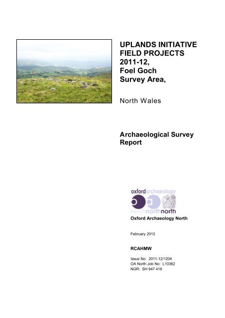
relatively rolling mountainous upland landscape (Fig 1), and is located to <strong>the</strong> north<br />
of <strong>the</strong> Bala and Bala Lakesides registered Historic Landscape No. 53<br />
(Cadw/ICOMOS 1998).<br />
1.2 OBJECTIVES<br />
1.2.1 The objectives of <strong>the</strong> project were:<br />
• to promote a wider and deeper understanding of upland areas and <strong>the</strong>ir role in<br />
Welsh history, in accordance with <strong>the</strong> aims of <strong>the</strong> Uplands Initiative;<br />
• to provide an accurate Level 1 survey of all identified m<strong>on</strong>uments (OA North<br />
2002).<br />
1.2.2 To achieve <strong>the</strong>se objectives <strong>the</strong> study area was subjected to a desk-based assessment<br />
and identificati<strong>on</strong> survey. The desk-based study, carried out in April 2011, c<strong>on</strong>sisted<br />
of a search of both published and unpublished records held by <strong>the</strong> Nati<strong>on</strong>al<br />
M<strong>on</strong>uments Record (NMR) of Wales, <strong>the</strong> Historic Envir<strong>on</strong>ment Records (HERs) of<br />
both Clwyd Powys and Gwynedd <str<strong>on</strong>g>Archaeological</str<strong>on</strong>g> Trusts, and <strong>the</strong> library and<br />
archives at OA North's offices in Lancaster. The fieldwork was carried out to fit in<br />
with access availability and wea<strong>the</strong>r c<strong>on</strong>diti<strong>on</strong>s, and was undertaken between May-<br />
June 2011 and January 2012<br />
1.2.3 This report sets out <strong>the</strong> results of <strong>the</strong> work, accompanied by a summary gazetteer of<br />
new sites (Appendix 1).<br />
For <strong>the</strong> use of RCAHMW © OA North: February 2012
Uplands Initiative Field Projects 2011-12: <str<strong>on</strong>g>Foel</str<strong>on</strong>g> <str<strong>on</strong>g>Goch</str<strong>on</strong>g> <str<strong>on</strong>g>Survey</str<strong>on</strong>g> Report 7<br />
2. METHODOLOGY<br />
2.1 PROJECT DESIGN<br />
2.1.1 A project design (OA North 2010a) was submitted by OA North in resp<strong>on</strong>se to a<br />
request for archaeological surveys of extensive areas of <strong>the</strong> Welsh Uplands; it was<br />
designed to meet <strong>the</strong> requirements of a brief issued by RCAHMW (2010). The<br />
project design provided for an initial archaeological desk-based study, followed by a<br />
field identificati<strong>on</strong> survey for <strong>the</strong> following areas: Yr Aran, <str<strong>on</strong>g>Foel</str<strong>on</strong>g> <str<strong>on</strong>g>Goch</str<strong>on</strong>g> and Cwm<br />
Prysor – Cwm Lliw. OA North was commissi<strong>on</strong>ed to undertake survey of <strong>on</strong>e of<br />
<strong>the</strong>se project areas and <strong>the</strong> present report relates to <strong>the</strong> <str<strong>on</strong>g>Foel</str<strong>on</strong>g> <str<strong>on</strong>g>Goch</str<strong>on</strong>g> area (Figs 1 and<br />
2). Subsequent to <strong>the</strong> initial survey, funding was made available for fur<strong>the</strong>r survey of<br />
a small parcel of land at Cefn Caer Euni, measuring 1.85 sq km in extent.<br />
2.2 DESK-BASED SURVEY<br />
2.2.1 Nati<strong>on</strong>al M<strong>on</strong>uments Record (NMR): an assessment was made of data held by <strong>the</strong><br />
RCAHMW, Aberystwyth, which was overlain <strong>on</strong>to digital 1:10,000 mapping for <strong>the</strong><br />
study area.<br />
2.2.2 Aerial Photographs: aerial photography from <strong>the</strong> NMR office was also c<strong>on</strong>sulted<br />
al<strong>on</strong>g with RCAHMW aerial photographic interpretati<strong>on</strong> of <strong>the</strong> study area.<br />
Informati<strong>on</strong> relating to possible new sites was annotated <strong>on</strong>to <strong>the</strong> field walking maps<br />
in GIS format.<br />
2.2.3 Historic Envir<strong>on</strong>ment Record (HER): an assessment was made of HER data held<br />
by both <strong>the</strong> Clwyd Powys and <strong>the</strong> Gwynedd <str<strong>on</strong>g>Archaeological</str<strong>on</strong>g> Trusts (CPAT and<br />
GAT), which was overlain <strong>on</strong>to <strong>the</strong> digital base map for <strong>the</strong> area.<br />
2.2.4 Ordnance <str<strong>on</strong>g>Survey</str<strong>on</strong>g> Mapping: all available historic mapping for <strong>the</strong> study area<br />
(provided by RCAHMW), was examined for <strong>the</strong> study area for indicati<strong>on</strong>s of<br />
historic sites that were not previously represented in <strong>the</strong> NMR and HER databases.<br />
2.2.5 World Wide Web: historic landscape characterisati<strong>on</strong>, parish records, census data<br />
and transcripts of some public records were obtained from archives and local<br />
histories <strong>on</strong> <strong>the</strong> internet. More modern data <strong>on</strong> <strong>the</strong> parish was also gleaned, which<br />
provided informati<strong>on</strong> about recent developments in <strong>the</strong> area.<br />
2.3 IDENTIFICATION SURVEY<br />
2.3.1 An identificati<strong>on</strong> survey to Level 1 (OA North 2002) was undertaken <strong>on</strong> <strong>the</strong> <str<strong>on</strong>g>Foel</str<strong>on</strong>g><br />
<str<strong>on</strong>g>Goch</str<strong>on</strong>g> study area. The identificati<strong>on</strong> survey represents <strong>the</strong> minimum standard of<br />
record for field investigati<strong>on</strong>, and is aimed at <strong>the</strong> discovery of previously unrecorded<br />
sites. Its objective is to record <strong>the</strong> existence, locati<strong>on</strong>, and extent of any<br />
archaeological site. The emphasis of <strong>the</strong> record lies in <strong>the</strong> written descripti<strong>on</strong>, which<br />
includes comments <strong>on</strong> character and c<strong>on</strong>diti<strong>on</strong>, and sites have been graded in terms<br />
of c<strong>on</strong>diti<strong>on</strong> and archaeological significance. Sites already identified within <strong>the</strong> study<br />
area by <strong>the</strong> NMR and HER were checked and recorded at <strong>the</strong> same level of<br />
c<strong>on</strong>sistency as <strong>the</strong> newly discovered sites. The whole study area, including both <strong>the</strong><br />
For <strong>the</strong> use of RCAHMW © OA North: February 2012
Uplands Initiative Field Projects 2011-12: <str<strong>on</strong>g>Foel</str<strong>on</strong>g> <str<strong>on</strong>g>Goch</str<strong>on</strong>g> <str<strong>on</strong>g>Survey</str<strong>on</strong>g> Report 8<br />
upland comm<strong>on</strong>s and surrounding improved and enclosed fringes, was examined.<br />
The survey involved four elements: rec<strong>on</strong>naissance, mapping, descripti<strong>on</strong> and digital<br />
photography. This generated core informati<strong>on</strong> for entry into <strong>the</strong> NMR and additi<strong>on</strong>al<br />
archive informati<strong>on</strong>, in accordance with <strong>the</strong> RCAHMW Revised Data Standard for<br />
Upland <str<strong>on</strong>g>Survey</str<strong>on</strong>g> (RCAHMW 2004).<br />
2.3.2 Each area was walked in transects of between 30m and 50m apart, depending <strong>on</strong><br />
local topography and ground cover. The archaeological detail was mapped using<br />
Leica differential GPS equipment which used real-time EGNOS correcti<strong>on</strong>s from<br />
geo-stati<strong>on</strong>ary satellites to achieve an accuracy of up to +-0.5m. The digital survey<br />
data was transferred as shapefiles into a GIS system (ArcGIS 9.3), and was<br />
superimposed <strong>on</strong>to <strong>the</strong> embedded digital Ordnance <str<strong>on</strong>g>Survey</str<strong>on</strong>g> data (Fig 3). The<br />
descriptive records were input <strong>on</strong>-site into a database <strong>on</strong> a Psi<strong>on</strong> portable palm<br />
computer; <strong>the</strong> more complex sites were also sketched <strong>on</strong>to paper pro-forma sheets.<br />
A photographic record of <strong>the</strong> sites was maintained using digital colour imagery and<br />
<strong>the</strong> images were used to accompany <strong>the</strong> present report.<br />
2.4 GAZETTEER OF SITES<br />
2.4.1 All of <strong>the</strong> informati<strong>on</strong> c<strong>on</strong>cerning archaeological sites within <strong>the</strong> assessed area was<br />
collated into a gazetteer (Appendix 1), which provides brief details of <strong>the</strong>ir locati<strong>on</strong>,<br />
period, type and altitude. Locati<strong>on</strong>s are given as ten-figure Nati<strong>on</strong>al Grid References<br />
where possible, and <strong>the</strong> positi<strong>on</strong> of each site is indicated <strong>on</strong> Figure 3.<br />
2.5 ARCHIVE<br />
2.5.1 A full archive has been produced to a professi<strong>on</strong>al standard in accordance with<br />
current English Heritage guidelines (1991) and <strong>the</strong> Guidelines for <strong>the</strong> Preparati<strong>on</strong><br />
of Excavati<strong>on</strong> Archives for L<strong>on</strong>g Term Storage (UKIC 1990). The project archive<br />
represents <strong>the</strong> collati<strong>on</strong> and indexing of all <strong>the</strong> data and material ga<strong>the</strong>red during <strong>the</strong><br />
course of <strong>the</strong> project. The archive is provided in <strong>the</strong> English Heritage Centre for<br />
Archaeology format, both as a printed document and digitally. A synopsis, including<br />
<strong>the</strong> index to <strong>the</strong> archive and a copy of <strong>the</strong> report, will be placed in <strong>the</strong> NMR,<br />
RCAHMW at Aberystwyth, Clwyd HER at CPAT, Welshpool and <strong>the</strong> Gwynedd<br />
HER at GAT, Bangor.<br />
For <strong>the</strong> use of RCAHMW © OA North: February 2012
Uplands Initiative Field Projects 2011-12: <str<strong>on</strong>g>Foel</str<strong>on</strong>g> <str<strong>on</strong>g>Goch</str<strong>on</strong>g> <str<strong>on</strong>g>Survey</str<strong>on</strong>g> Report 9<br />
3. TOPOGRAPHICAL AND HISTORICAL BACKGROUND<br />
3.1 LOCATION AND TOPOGRAPHY<br />
3.1.1 The study area of <str<strong>on</strong>g>Foel</str<strong>on</strong>g> <str<strong>on</strong>g>Goch</str<strong>on</strong>g> covers an area of 16.69 sqkm and c<strong>on</strong>sists of rolling<br />
moorland with north- and south-facing slopes <strong>on</strong> ei<strong>the</strong>r side of <strong>the</strong> chain of<br />
mountains running al<strong>on</strong>g <strong>the</strong> county boundary Gwynedd and C<strong>on</strong>wy (Fig 1). The<br />
nor<strong>the</strong>rn side of <strong>the</strong> area is defined for <strong>the</strong> most part by <strong>the</strong> county boundary<br />
between Gwynedd and C<strong>on</strong>wy and roughly 1/7 th of <strong>the</strong> north end of <strong>the</strong> study area<br />
lies in <strong>the</strong> latter county (Fig 2). The undulating ridgeline which carries <strong>the</strong> county<br />
boundary includes <strong>the</strong> summits of: Craig y Llwynog; Garnedd Fawr; <str<strong>on</strong>g>Foel</str<strong>on</strong>g> <str<strong>on</strong>g>Goch</str<strong>on</strong>g><br />
(highest at 611m OD); Orddu; Pen y Cerrig-serth; and Moel Cae’r-ceiliog. The rest<br />
of <strong>the</strong> study area comprises rough grazing <strong>on</strong> <strong>the</strong> flanks of a group of interspersed<br />
hills of slightly lower altitude, at: <str<strong>on</strong>g>Foel</str<strong>on</strong>g> Fach, Moel Emoel, Moel Darren and Bryn<br />
Bras (Plate 1). The hills have cwms with watercourses radiating away from <strong>the</strong><br />
watershed in every directi<strong>on</strong> but with <strong>the</strong> most extensive directi<strong>on</strong> of flow being to<br />
<strong>the</strong> south al<strong>on</strong>g Nant Cefn-coch, Nant Cwm-da, Nant Cae’r-ceiliog and <strong>the</strong> tributary<br />
streams draining into Llyn Maen Bras. The topography surrounding Llyn Maen Bras<br />
is much gentler in profile and c<strong>on</strong>tains an extensive boggy area (Plate 2). At present<br />
<strong>the</strong> upland is mostly comm<strong>on</strong> land, with some large parcels of fenced enclosure of<br />
predominantly twentieth century date, which have formalised most of <strong>the</strong> areas of<br />
comm<strong>on</strong> that was traditi<strong>on</strong>ally used by each of <strong>the</strong> lowland farms. The relatively<br />
recently established enclosures within Cwm Da are still c<strong>on</strong>tested by <strong>the</strong> local<br />
farmers. The south of <strong>the</strong> study area also c<strong>on</strong>tains <strong>the</strong> upper limits of two historic<br />
‘ffridd’ enclosures associated with farmsteads in Pentre-tai-yn-y-cwm and, to <strong>the</strong><br />
west, <strong>the</strong> field-system surrounding Eglwys-Anne Warren Ffridd. The majority of <strong>the</strong><br />
separate block of land at Cefn Caer Euni remains low-lying open comm<strong>on</strong> skirted by<br />
enclosed fields.<br />
3.2 GEOLOGY<br />
3.2.1 The exposed solid geology of <strong>the</strong> study area c<strong>on</strong>sists almost entirely of faulted bands<br />
of Ordovician age rock of <strong>the</strong> Bala (Caradoc) series. The south-west tip of <strong>the</strong> area<br />
is of <strong>the</strong> Bala (Ashgill) series (British Geological <str<strong>on</strong>g>Survey</str<strong>on</strong>g> 1994; Neville George and<br />
Smith 1961). The overlying soils are a mixture of various soil types dependant <strong>on</strong><br />
<strong>the</strong> parent rock (Soil <str<strong>on</strong>g>Survey</str<strong>on</strong>g> 1983). The area is dominated by loamy, permeable<br />
upland soils of <strong>the</strong> Hafren associati<strong>on</strong> in <strong>the</strong> bulk of <strong>the</strong> area. This is flanked <strong>on</strong> <strong>the</strong><br />
west, south and east sides by well-drained fine loamy upland soils of <strong>the</strong> Manod<br />
associati<strong>on</strong> <strong>on</strong> <strong>the</strong> steeper valley sides (ibid).<br />
3.3 ARCHAEOLOGICAL AND HISTORICAL BACKGROUND<br />
3.3.1 Prehistoric to Roman: prior to <strong>the</strong> present survey several sites were recorded<br />
within <strong>the</strong> study area as being of prehistoric, and more specifically Br<strong>on</strong>ze Age, in<br />
date. There is a funerary cairn located <strong>on</strong> <strong>the</strong> summit of Garnedd Fawr (NMR<br />
303461; Plate 3), and a closely related pair of funerary/ritual m<strong>on</strong>uments <strong>on</strong> top of<br />
<strong>the</strong> small block of comm<strong>on</strong> ground at Caer Euni. These c<strong>on</strong>sist of an unusual ring<br />
For <strong>the</strong> use of RCAHMW © OA North: February 2012
Uplands Initiative Field Projects 2011-12: <str<strong>on</strong>g>Foel</str<strong>on</strong>g> <str<strong>on</strong>g>Goch</str<strong>on</strong>g> <str<strong>on</strong>g>Survey</str<strong>on</strong>g> Report 10<br />
cairn comprising, originally, four c<strong>on</strong>centric boulder rings set into a low cairn and a<br />
kerbed cairn circle (NMR 275897 and 400457; Lynch 1995, 61). In additi<strong>on</strong>, <strong>the</strong>re<br />
are also two round cairns located <strong>on</strong> Cefn Caer Euni recorded in <strong>the</strong> Gwynedd HER<br />
(NMR 519351 and 519349). Fur<strong>the</strong>r prehistoric sites are located nearby at Coed y<br />
Bedo farm (in <strong>the</strong> valley between <strong>the</strong> two porti<strong>on</strong>s of study area), which include <strong>the</strong><br />
Maen y Rhos standing st<strong>on</strong>e (NMR 303459: Scheduled ME 228), found in close<br />
proximity to a pair of burnt mounds (HER 2885).<br />
3.3.2 Ir<strong>on</strong> Age/Romano-British activity in <strong>the</strong> regi<strong>on</strong> seems to have had str<strong>on</strong>g defensive<br />
and military comp<strong>on</strong>ents, although most sites are fur<strong>the</strong>r to <strong>the</strong> south of <strong>the</strong> study<br />
area in <strong>the</strong> lowlands, mainly around <strong>the</strong> natural routeway in <strong>the</strong> valley c<strong>on</strong>taining<br />
Bala Lake (Cadw et al 1998, 69). There is little evidence from <strong>the</strong> HER of upland<br />
occupati<strong>on</strong> in <strong>the</strong> regi<strong>on</strong> immediately surrounding <strong>the</strong> present study area, although<br />
this may reflect a lack of archaeological investigati<strong>on</strong>. The route through <strong>the</strong> valley<br />
around Bala Lake has <strong>the</strong> potential to have been used as far back as <strong>the</strong> prehistoric<br />
period, prior to Roman occupati<strong>on</strong> (Bowen and Gresham 1967, 3). The study area<br />
c<strong>on</strong>tains a hillfort at Cefn Caer Euni located overlooking <strong>the</strong> valley to <strong>the</strong> north-east<br />
of Bala (NMR 93712; Lynch 1995, 83), and nearby <strong>the</strong>re is a single possible round<br />
house (NMR 519350). The distributi<strong>on</strong> of lowland findspots of st<strong>on</strong>e axes and axe<br />
hammers show a c<strong>on</strong>centrati<strong>on</strong> <strong>on</strong> <strong>the</strong> flanks of <strong>the</strong> hills located <strong>on</strong> <strong>the</strong> north side of<br />
Bala Lake (Cadw et al 1998, 40) which may point towards lowland occupati<strong>on</strong> in<br />
this area. There are Roman military complexes located at ei<strong>the</strong>r end of Bala Lake,<br />
which are joined by <strong>the</strong> putative Roman road to Chester (NMR 303524). There are<br />
<strong>the</strong> remains of an auxiliary fort at Caer Gai <strong>on</strong> <strong>the</strong> south-west end of <strong>the</strong> lake (NMR<br />
95436) and <strong>the</strong> cropmark remains of a large military complex at Llanfor <strong>on</strong> <strong>the</strong><br />
north-east end of <strong>the</strong> lake (NMR 95436). The complexes at Llanfor also revealed a<br />
putative destroyed st<strong>on</strong>e circle (Bowen and Gresham 1967, 283) and geophysical<br />
anomalies which may relate to putative Br<strong>on</strong>ze Age burial and ritual sites (Cadw et<br />
al 1998, 69). A fur<strong>the</strong>r round house site was recorded from <strong>the</strong> Gwynedd HER, but<br />
<strong>the</strong> present survey revealed that <strong>the</strong> structure at Moel Emoel (NMR 519305; Plate<br />
4), was more likely to be a later medieval or post-medieval stock management<br />
feature.<br />
3.3.3 Medieval: <strong>the</strong>re is <strong>on</strong>ly limited physical or documentary evidence for <strong>the</strong> dispersed<br />
upland habitati<strong>on</strong> and exploitati<strong>on</strong> in <strong>the</strong> study area in <strong>the</strong> medieval period, such as<br />
l<strong>on</strong>ghouses and/or o<strong>the</strong>r domestic structures and elements of field-systems, which<br />
are prevalent elsewhere in <strong>the</strong> regi<strong>on</strong> (OA North 2009; Davies 1973). A single oval<br />
enclosure <strong>on</strong> Cefn Caer Euni, recorded in <strong>the</strong> HER, was found during <strong>the</strong> present<br />
survey to be a well-preserved l<strong>on</strong>ghouse (NMR 519352). There is a tentative<br />
attributi<strong>on</strong> of <strong>the</strong> placename Eglwys Anne in <strong>the</strong> south-west of <strong>the</strong> study area as<br />
being <strong>the</strong> site of a medieval hermitage/church (NMR 43836; RCAHMW 1914 and<br />
1921), and <strong>the</strong>re is a dubious triangular platform adjacent to a spring which is<br />
supposedly <strong>the</strong> site of <strong>the</strong> building (Plate 5). A fur<strong>the</strong>r antiquarian site was recorded<br />
in 1698 by Edward Lhuyd, which was <strong>the</strong> findspot of a brass tripod pot or kettle <strong>on</strong><br />
Yr Orddu mountain (NMR 519290; RCAHMW 1914, 129). A putative cockpit was<br />
also recorded <strong>on</strong> <strong>the</strong> open fell just to <strong>the</strong> north of Coed y Bedo farm (NMR<br />
303458; Plate 6), and, nearby, was a possible farmstead within a small enclosure<br />
(NMR 519291). The farmstead of Coed y Bedo itself (just outside of <strong>the</strong> study area)<br />
is a Grade II Listed building (NMR 28290; LB – 4671) and is said (NMR entry) to<br />
have <strong>on</strong>ce been <strong>the</strong> home of <strong>the</strong> bard Bedo Aedderen around c 1500. The farmhouse<br />
For <strong>the</strong> use of RCAHMW © OA North: February 2012
Uplands Initiative Field Projects 2011-12: <str<strong>on</strong>g>Foel</str<strong>on</strong>g> <str<strong>on</strong>g>Goch</str<strong>on</strong>g> <str<strong>on</strong>g>Survey</str<strong>on</strong>g> Report 11<br />
is a good example of a timber-framed structure that had been encased in st<strong>on</strong>e in <strong>the</strong><br />
early seventeenth century.<br />
3.3.4 Within <strong>the</strong> medieval period <strong>the</strong> majority of <strong>the</strong> study area was <strong>on</strong> <strong>the</strong> nor<strong>the</strong>rn edge<br />
of <strong>the</strong> commote of Penllyn in Meri<strong>on</strong>ethshire and was under <strong>the</strong> c<strong>on</strong>trol at first of<br />
<strong>the</strong> Princes of Gwynedd and, subsequently, <strong>the</strong> English Crown (Beverly-Smith and<br />
Beverly-Smith 2001, 209). The area was relatively uninhabited in <strong>the</strong> early medieval<br />
period, especially <strong>the</strong> rugged upland areas, although it was exploited latterly for its<br />
extensive upland woodland resources, hunting and moorland grazing as part of <strong>the</strong><br />
Forest of Snowd<strong>on</strong>. Tenants of <strong>the</strong> Penllyn commote were taxed <strong>on</strong> <strong>the</strong>ir produce,<br />
which largely comprised renders in livestock and dairy produce and, to a lesser<br />
extent, oats (op cit, 42). The mountains formed suitable areas for both legal and<br />
illegal encroachment of ffridd enclosures in <strong>the</strong> late medieval period, and possibly<br />
earlier, with widespread cattle-based transhumant hafod-style settlement and<br />
agriculture in <strong>the</strong> study area.<br />
3.3.5 The landscape of <strong>the</strong> study area, and <strong>the</strong> surrounding regi<strong>on</strong> around Bala, was, from<br />
<strong>the</strong> Tudor period, shaped predominantly by <strong>the</strong> development of <strong>the</strong> Rhiwlas Estate<br />
under <strong>the</strong> Price family. Large tracts of <strong>the</strong> upland moorland remained ostensibly<br />
Crown Lands of <strong>the</strong> Forest of Snowd<strong>on</strong>; however, <strong>the</strong> farms and cultivable lands<br />
surrounding <strong>the</strong>se areas, and also certain encroachments into <strong>the</strong> forest, were<br />
increasingly amalgamated into <strong>the</strong> estate through crown leases (Thomas 1967, 212).<br />
The Forest of Snowd<strong>on</strong> suffered particularly badly through illegal encroachment and<br />
as <strong>the</strong> 'Extents of Meri<strong>on</strong>eth' manuscript had been lost, at some stage prior to 1573<br />
(Evans 2005), it was extremely difficult to ascertain which encroachments and<br />
landholdings were medieval freehold land. At <strong>the</strong> end of <strong>the</strong> sixteenth century<br />
(during <strong>the</strong> Crown survey of 1592) <strong>the</strong> emerging landed estates fought hard against<br />
<strong>the</strong> disclosure of c<strong>on</strong>cealed lands which had been enclosed as ffriddoedd from <strong>the</strong><br />
earlier comm<strong>on</strong>s and m<strong>on</strong>astic upland grazing lands (op cit, 660). In particular, <strong>the</strong><br />
Dissoluti<strong>on</strong> of <strong>the</strong> M<strong>on</strong>asteries directly led to <strong>the</strong> lands of Ystrad Marchell of some<br />
1,400 acres in Penllyn coming into <strong>the</strong> hands of <strong>the</strong> Rhiwlas estate (GAT 2006, 1;<br />
Thomas 1967, 661). The main focus of <strong>the</strong> estate, however, lay to <strong>the</strong> west of <strong>the</strong><br />
study area around Cwmtirmynach, which had again been acquired from <strong>the</strong> remnants<br />
of m<strong>on</strong>astic lands, this time of Basingwerk Abbey (ibid; Evans 2005, 283).<br />
3.3.6 Post-Medieval: <strong>the</strong> identified sites within <strong>the</strong> Clwyd Powys HER and Gwynedd<br />
HER were limited to several phases of archeological activity. Firstly a landscape<br />
investigati<strong>on</strong> recorded in 1988 systematically surveyed <strong>the</strong> area excluded from <strong>the</strong><br />
current archaeological survey <strong>on</strong> <strong>the</strong> west flank of Garnedd Fawr (Fig 2). It<br />
identified thirteen sites, including springs, trackways, sheepfolds and peat cuttings<br />
(NMR 519292 – 519304). Sec<strong>on</strong>dly, cartographic evidence has been used to<br />
identify fur<strong>the</strong>r m<strong>on</strong>uments, which, for <strong>the</strong> most part, c<strong>on</strong>sist of boundary st<strong>on</strong>es<br />
that are located <strong>on</strong> <strong>the</strong> county boundary between C<strong>on</strong>wy and Gwynedd running<br />
east/west al<strong>on</strong>g <strong>the</strong> nor<strong>the</strong>rn part of <strong>the</strong> study area (NMR 519233, 519256, 519294-<br />
519295, 519306-519310 and 519313-519318). O<strong>the</strong>r sites include: a relict<br />
farmstead within a rectangular enclosure (NMR 412788); a mountain trackway<br />
(NMR 519311); a sheepfold (NMR 519 312); and a stock enclosure (NMR<br />
519291).<br />
3.3.7 Encroachments <strong>on</strong> <strong>the</strong> comm<strong>on</strong>s, held as Crown Lands, were undertaken by<br />
manorial lords, and tenants alike, with widespread cattle-based transhumant hafod-<br />
For <strong>the</strong> use of RCAHMW © OA North: February 2012
Uplands Initiative Field Projects 2011-12: <str<strong>on</strong>g>Foel</str<strong>on</strong>g> <str<strong>on</strong>g>Goch</str<strong>on</strong>g> <str<strong>on</strong>g>Survey</str<strong>on</strong>g> Report 12<br />
style settlement and agriculture in <strong>the</strong> regi<strong>on</strong>. These encroachments were to c<strong>on</strong>tinue<br />
down <strong>the</strong> centuries by a process of neglect (by <strong>the</strong> Crown), corrupti<strong>on</strong> and stealth<br />
(op cit, 31). Large tracts of <strong>the</strong> upland moorland presumably remained ostensibly<br />
Crown Lands in <strong>the</strong> post-medieval period; however, <strong>the</strong> farms and cultivable lands<br />
surrounding <strong>the</strong>se areas, toge<strong>the</strong>r with certain encroachments <strong>on</strong> to <strong>the</strong> comm<strong>on</strong>s,<br />
were increasingly amalgamated into large estates through crown leases. There was a<br />
fur<strong>the</strong>r phase of enclosure, added after <strong>the</strong> ti<strong>the</strong> schedule, which reflects <strong>the</strong> largescale<br />
acquisiti<strong>on</strong> of Crown Lands by means of <strong>the</strong> Enclosure Acts of <strong>the</strong> mid-1860s.<br />
The Enclosure Acts c<strong>on</strong>solidated holdings of comm<strong>on</strong> grazing into enclosed<br />
sheepwalks. The majority of <strong>the</strong> study area was open comm<strong>on</strong> land in 1847<br />
(Thomas 1967, 232) and, apart from land around Moel Emoel, remained comm<strong>on</strong><br />
after <strong>the</strong> Enclosure, unlike, for example, land to <strong>the</strong> west around Llyn Celyn which<br />
all came under <strong>the</strong> ownership of <strong>the</strong> Rhiwlas estate (OA North 2009). The lowland<br />
distributi<strong>on</strong> of land ownership in <strong>the</strong> valley below <strong>the</strong> study area was <strong>on</strong>e of<br />
c<strong>on</strong>solidated landholdings to <strong>the</strong> south-west associated with <strong>the</strong> Rhiwlas estate and<br />
individual private freeholders with comm<strong>on</strong> grazing rights running up Cwm Main to<br />
<strong>the</strong> south and east. The private landholdings were increasingly amalgamated in <strong>the</strong><br />
late-nineteenth/twentieth century by both intermarriage and aband<strong>on</strong>ment of small<br />
unprofitable farmsteads. The hamlet of Pentre-tai-yn-y-cwm within <strong>the</strong> isolated cwm<br />
in <strong>the</strong> centre/south of <strong>the</strong> study area was reduced from over 90 individuals to just<br />
<strong>on</strong>e family in this period (Mr E M Owen pers com).<br />
3.3.8 By <strong>the</strong> nineteenth century <strong>the</strong> Rhiwlas estate had reached its maximum extent<br />
through prudent land acquisiti<strong>on</strong>s and intermarriage; by <strong>the</strong> time of <strong>the</strong> ti<strong>the</strong><br />
schedules in <strong>the</strong> 1840s it was <strong>the</strong> third largest estate in Meri<strong>on</strong>eth with 14,751 acres<br />
(Thomas 1967, 232-233 [Fig 4] and 238). By <strong>the</strong> end of <strong>the</strong> century it owned almost<br />
16,500 acres (GAT 2006, 1), and <strong>the</strong> estate actively extended <strong>the</strong> area of<br />
cultivatable lands into <strong>the</strong> uplands with improvements of <strong>the</strong> existing ffridd<br />
enclosures through drainage and st<strong>on</strong>e clearance. The study area mostly lay outside<br />
of <strong>the</strong> large-scale land acquisiti<strong>on</strong>s undertaken by <strong>the</strong> estate in <strong>the</strong> period of <strong>the</strong><br />
Enclosure Acts in <strong>the</strong> 1860s but <strong>the</strong>ir landholding in <strong>the</strong> study area encompassed<br />
land to <strong>the</strong> south-west edge of <strong>the</strong> area. This c<strong>on</strong>tained Moel Emoel which was<br />
recorded as waste <strong>on</strong> a schedule of land, dated 1863, immediately prior to <strong>the</strong> estate<br />
buying it from <strong>the</strong> Crown (Z/DDD/1/191). Surrounding land at <strong>the</strong> farmstead of<br />
Eglwys-Anne was presumably already owned by <strong>the</strong> estate pre-1860s and this was<br />
where <strong>the</strong> Warren Ffridd was located. The land of <strong>the</strong> study area was predominantly<br />
held as upland sheepwalks for stock grazing and to a lesser extent as shooting<br />
moorland for <strong>the</strong> estate <strong>on</strong> <strong>the</strong> south-west end.<br />
3.3.9 The Rhiwlas Estate had first developed shooting lands nearer to <strong>the</strong> estate seat with<br />
a mixture of rabbit warrens, pheasant coverts and grouse shooting. The study area<br />
did not c<strong>on</strong>tain <strong>on</strong>e of <strong>the</strong> main grouse shooting moors, such as that at Arenig Fach<br />
(OA North 2009) but did c<strong>on</strong>tain 350 acres of land at Eglwys-Anne which was<br />
designated as <strong>on</strong>e of <strong>the</strong> three rabbit warrens (with attached pheasant covert)<br />
recorded <strong>on</strong> an undated (?late nineteenth century) schedule in <strong>the</strong> Rhiwlas archive<br />
(Z/DDD/1/200). This block of land was leased out <strong>on</strong> <strong>the</strong> schedule for a yearly rent<br />
of £200 to Herbert J Parkes esq. Ano<strong>the</strong>r warren was located just south of <strong>the</strong> study<br />
area at College Warren and a fur<strong>the</strong>r <strong>on</strong>e to <strong>the</strong> west at Fr<strong>on</strong> <str<strong>on</strong>g>Goch</str<strong>on</strong>g> where numerous<br />
pillow mounds still survive. To give an example of <strong>the</strong> industrial scale of <strong>the</strong><br />
For <strong>the</strong> use of RCAHMW © OA North: February 2012
Uplands Initiative Field Projects 2011-12: <str<strong>on</strong>g>Foel</str<strong>on</strong>g> <str<strong>on</strong>g>Goch</str<strong>on</strong>g> <str<strong>on</strong>g>Survey</str<strong>on</strong>g> Report 13<br />
enterprise, <strong>on</strong>e particular shoot at Moel Emoel <strong>on</strong> <strong>the</strong> 7 th October 1885 dispatched<br />
5096 rabbits and 5106 game between 10am and 5pm (Price 1899, 29).<br />
For <strong>the</strong> use of RCAHMW © OA North: February 2012
Uplands Initiative Field Projects 2011-12: <str<strong>on</strong>g>Foel</str<strong>on</strong>g> <str<strong>on</strong>g>Goch</str<strong>on</strong>g> <str<strong>on</strong>g>Survey</str<strong>on</strong>g> Report 14<br />
4. RESULTS OF THE DESK-BASED STUDY<br />
4.1 DESK-BASED STUDY SUMMARY<br />
4.1.1 Cartographic Evidence: examinati<strong>on</strong> of <strong>the</strong> historic maps, <strong>the</strong> Ordnance <str<strong>on</strong>g>Survey</str<strong>on</strong>g><br />
(OS) First and subsequent editi<strong>on</strong>s of <strong>the</strong> 6” and 25” to 1 mile mapping, has <strong>the</strong><br />
potential to inform <strong>the</strong> development of enclosed lands and higher unenclosed<br />
moorland; however, in practice <strong>the</strong>re was little significant difference revealed<br />
between <strong>the</strong> extensive OS First Editi<strong>on</strong> mapping (1875-1901) and that of today.<br />
There are several old ffridd enclosures surrounding Eglwys-Anne in <strong>the</strong> west of <strong>the</strong><br />
study area that were possibly associated with a warren, and a ffridd enclosure<br />
located to <strong>the</strong> north of Pentre-tai-yn-y-cwm in <strong>the</strong> south of <strong>the</strong> study area that are<br />
associated with <strong>the</strong> ruined farm of Beudy Tafolog. A small rectangular enclosure at<br />
<strong>the</strong> south-west end of Cefn Caer Euni was probably a small farmstead or squatter’s<br />
cottage. There are also fenced enclosures, formalised straight-sided boundaries,<br />
crossing <strong>the</strong> roughly–grazed uplands, located <strong>on</strong> <strong>the</strong> east flank of Orddu <strong>on</strong> <strong>the</strong> east<br />
side of <strong>the</strong> study area and <strong>on</strong> Y Gessail <strong>on</strong> <strong>the</strong> north-west end. Very few sites of<br />
archaeological interest are marked <strong>on</strong> <strong>the</strong> historic OS mapping, <strong>the</strong> majority of <strong>the</strong>se<br />
c<strong>on</strong>sist of a chain of boundary st<strong>on</strong>es located al<strong>on</strong>g <strong>the</strong> county boundary between<br />
C<strong>on</strong>wy and Gwynedd, and also included <strong>the</strong> summit cairn <strong>on</strong> Garnedd Fawr. The<br />
hillfort <strong>on</strong> Cefn Caer Euni was depicted <strong>on</strong> mapping. There are also multiple sinuous<br />
trackways running in all directi<strong>on</strong>s up <strong>on</strong>to <strong>the</strong> upland sheepwalks from <strong>the</strong> lowland<br />
farms, stock enclosures <strong>on</strong> Moel Emoel in <strong>the</strong> south of <strong>the</strong> study area and also <strong>on</strong><br />
<strong>the</strong> east flank <strong>on</strong> Bryn Bras <strong>on</strong> <strong>the</strong> south-east of <strong>the</strong> area, al<strong>on</strong>g with single examples<br />
of sheep folds and sheep shelters. The reservoir at Llyn Maen Bras, located in <strong>the</strong><br />
south-west of <strong>the</strong> area, with its dam and curtain of c<strong>on</strong>iferous plantati<strong>on</strong>, was shown<br />
as having been c<strong>on</strong>structed by <strong>the</strong> time of <strong>the</strong> OS First Editi<strong>on</strong> mapping (1875-<br />
1901).<br />
4.1.2 Aerial Photographic Interpretati<strong>on</strong>: digital aerial photographic mapping and<br />
interpretati<strong>on</strong> was supplied by <strong>the</strong> RCAHMW under <strong>the</strong> auspices of <strong>the</strong> Uplands<br />
Initiative (Ray 2011). The interpretati<strong>on</strong> identified limited potential remains of<br />
archaeological interest. The most important being an area of cultivati<strong>on</strong> at Eglwys<br />
Anne farmstead, numerous moorland trackways and several stock enclosures. These<br />
sites clearly relate to highly visible episodes of post-medieval moorland exploitati<strong>on</strong>.<br />
The interpretati<strong>on</strong> did identify <strong>the</strong> round cairn <strong>on</strong> Cwm Cywen.<br />
4.1.3 Gwynedd Historic Envir<strong>on</strong>ment Record (HER), Clwyd Powys Historic<br />
Envir<strong>on</strong>ment Record, Nati<strong>on</strong>al M<strong>on</strong>uments Record of Wales (NMR): in total, 44<br />
unduplicated sites were recorded within <strong>the</strong> HER and NMR; comprising five Br<strong>on</strong>ze<br />
Age sites, <strong>on</strong>e prehistoric site, two Ir<strong>on</strong> Age sites, three medieval sites, 26 postmedieval<br />
sites and seven sites of unknown date (Table 1; Fig 3).<br />
For <strong>the</strong> use of RCAHMW © OA North: February 2012
Uplands Initiative Field Projects 2011-12: <str<strong>on</strong>g>Foel</str<strong>on</strong>g> <str<strong>on</strong>g>Goch</str<strong>on</strong>g> <str<strong>on</strong>g>Survey</str<strong>on</strong>g> Report 15<br />
5. SURVEY RESULTS<br />
5.1 INTRODUCTION<br />
5.1.1 The survey examined both known and previously unknown sites, which ranged in<br />
date from <strong>the</strong> Br<strong>on</strong>ze Age through to <strong>the</strong> post-medieval and modern periods. The<br />
majority of <strong>the</strong> sites c<strong>on</strong>sisted of widely dispersed single m<strong>on</strong>uments, although both<br />
prehistoric cairns and medieval/post-medieval domestic sites and stock enclosures<br />
were often found in pairs. There is also an extensive grouping of boundary marker<br />
st<strong>on</strong>es running al<strong>on</strong>g <strong>the</strong> county boundary. All <strong>the</strong> sites identified by <strong>the</strong><br />
documentary study were examined; <strong>the</strong>ir locati<strong>on</strong>s and extent were updated <strong>on</strong> <strong>the</strong><br />
mapping, as required, and <strong>the</strong> site descripti<strong>on</strong>s were enhanced. Both new and old<br />
sites are indicated <strong>on</strong> Figure 3. A porti<strong>on</strong> of <strong>the</strong> study area identified in <strong>the</strong> project<br />
design, measuring 0.7sq km, was not subject to walkover survey as this had already<br />
been systematically surveyed in 1988 by Gwynedd <str<strong>on</strong>g>Archaeological</str<strong>on</strong>g> Trust (Fig 2).<br />
This survey had identified thirteen ostensibly post-medieval agricultural sites, all of<br />
which have been given new NMR numbers (NMR 519292 - 519304).<br />
5.1.2 Previously Recorded Sites: <strong>the</strong> desk-based study identified eight pre-survey NMR<br />
sites, whilst a fur<strong>the</strong>r 36 unduplicated HER sites were also updated and given new<br />
NMR numbers. The majority of <strong>the</strong> known sites were c<strong>on</strong>firmed by <strong>the</strong> identificati<strong>on</strong><br />
survey; excepting those within <strong>the</strong> area excluded from <strong>the</strong> survey (Fig 2), and a few<br />
boundary st<strong>on</strong>es that could not be located.<br />
5.1.3 New Sites: in total, 127 new sites were identified representing a substantial<br />
numerical increase in <strong>the</strong> number of sites within <strong>the</strong> study area and are summarised<br />
below (Table 1).<br />
Period<br />
Pre-<str<strong>on</strong>g>Survey</str<strong>on</strong>g><br />
Number<br />
Post-<str<strong>on</strong>g>Survey</str<strong>on</strong>g><br />
Number<br />
Prehistoric 1 1 0<br />
Br<strong>on</strong>ze Age 5 16 11<br />
Ir<strong>on</strong> Age 2 2 0<br />
Medieval 3 7 4<br />
Post-Medieval 26 136 110<br />
Unknown 7 9 2<br />
Total 44 171 127<br />
Table 1: Pre- and Post-<str<strong>on</strong>g>Survey</str<strong>on</strong>g> Site Numbers<br />
Numerical<br />
Increase<br />
5.1.4 Altitude range of sites: <strong>the</strong> overall site density was 10.24 sites per sqkm, which was<br />
spread according to altitude as shown in Table 2. The greatest density of sites was<br />
between <strong>the</strong> 350-374m OD range.<br />
For <strong>the</strong> use of RCAHMW © OA North: February 2012
Uplands Initiative Field Projects 2011-12: <str<strong>on</strong>g>Foel</str<strong>on</strong>g> <str<strong>on</strong>g>Goch</str<strong>on</strong>g> <str<strong>on</strong>g>Survey</str<strong>on</strong>g> Report 16<br />
Height Range Existing Sites New Sites Total<br />
275-299m 0 1 1<br />
300-324m 0 4 4<br />
325-349m 3 15 18<br />
350-374m 9 25 34<br />
375-399m 1 15 16<br />
400-424m 0 19 19<br />
425-449m 4 11 15<br />
450-474m 5 19 24<br />
475-499m 4 5 9<br />
500-524m 5 5 10<br />
525-549m 6 5 11<br />
550-574m 5 1 6<br />
575-599m 0 1 1<br />
600-624m 2 1 3<br />
Total 44 127 171<br />
Table 2: Pre- and Post- survey site numbers with respect to altitude<br />
5.1.5 Range of site types: <strong>the</strong> sites identified from <strong>the</strong> present survey, and previously<br />
identified within <strong>the</strong> NMR and HERs, fall into fifteen general types, which are<br />
defined as shown in Table 3.<br />
Type Existing Sites New Sites Total<br />
Boundary Bank, Boundary St<strong>on</strong>e, Marker Cairn<br />
Clearance Cairn, St<strong>on</strong>e<br />
17 29 46<br />
Building Platform, Farmstead, L<strong>on</strong>ghouse, Structure 4 6 10<br />
Cockpit 1 0 1<br />
Dam, P<strong>on</strong>d, Spring 3 3 6<br />
Field-System 0 1 1<br />
Findspot 1 0 1<br />
Hermitage 1 0 1<br />
Hillfort 1 0 1<br />
Round house 2 0 2<br />
Peat Cutting, Peat Stand, Potash Kiln 3 6 9<br />
Quarry 0 9 9<br />
Kerb Cairn, Ring Cairn, Round Cairn 5 11 16<br />
Sheep Fold, Sheep Shelter, Shelter 2 35 37<br />
Stock Enclosure 1 8 9<br />
For <strong>the</strong> use of RCAHMW © OA North: February 2012
Uplands Initiative Field Projects 2011-12: <str<strong>on</strong>g>Foel</str<strong>on</strong>g> <str<strong>on</strong>g>Goch</str<strong>on</strong>g> <str<strong>on</strong>g>Survey</str<strong>on</strong>g> Report 17<br />
Trackway 3 19 22<br />
Total 44 127 171<br />
5.2 BRONZE AGE/PREHISTORIC<br />
Table 3: Range of Site Types<br />
5.2.1 Prehistoric Cairns: previously discovered potential funerary sites were limited to<br />
<strong>the</strong> paired ring cairn and kerbed cairn circle (NMR 275897 and 400457) and two<br />
round cairns located <strong>on</strong> Cefn Caer Euni and <strong>the</strong> single summit round cairn at<br />
Garnedd Fawr (NMR 303461; Plate 2). All <strong>the</strong> round cairns had, to some degree,<br />
been damaged by later disturbance as a result of antiquarian investigati<strong>on</strong>s and <strong>the</strong><br />
summit cairn was used as part of <strong>the</strong> county boundary between Gwynedd and<br />
C<strong>on</strong>wy, and had had a boundary st<strong>on</strong>e placed <strong>on</strong> top of it (NMR 519294).<br />
5.2.2 The current survey identified several fur<strong>the</strong>r potentially prehistoric sites (Fig 4), ten<br />
of which are almost certainly funerary cairns and a single possible ring cairn. All of<br />
<strong>the</strong> newly discovered m<strong>on</strong>uments were in five groupings in separate parts of <strong>the</strong><br />
study area. Only three of <strong>the</strong> cairns could be classed as summit cairns, those within<br />
<strong>the</strong> hillfort at Cefn Caer Euni; as for <strong>the</strong> rest <strong>the</strong>ir less-striking locati<strong>on</strong>s may in part<br />
explain why <strong>the</strong>y have not previously been identified. The majority of prehistoric<br />
sites recorded (and scheduled) in <strong>the</strong> mountainous regi<strong>on</strong>, immediately surrounding<br />
<strong>the</strong> study area, are summit cairns, although examples of cairns located <strong>on</strong> lower land<br />
were found nearby during previous investigati<strong>on</strong>s (OA North 2005a; 2009 and<br />
2010b). The newly discovered cairns were typically located ei<strong>the</strong>r adjacent to <strong>the</strong><br />
summits, or <strong>on</strong> land that was slightly sheltered and just below <strong>the</strong> summits <strong>on</strong> lower<br />
shelved land <strong>on</strong> <strong>the</strong> flanks of <strong>the</strong> hills. Many had good viewsheds towards lower land<br />
in at least a 180 degree directi<strong>on</strong>al arc. The first grouping was a pair of m<strong>on</strong>uments,<br />
and included a round cairn (NMR 519227; Plate 7) and a ring cairn (NMR 519226;<br />
Plate 8), set some 24m apart <strong>on</strong> a small plateau located <strong>on</strong> <strong>the</strong> north-west flank of<br />
<str<strong>on</strong>g>Foel</str<strong>on</strong>g> <str<strong>on</strong>g>Goch</str<strong>on</strong>g>. The round cairn is quite large, surviving to 14m in diameter by 2m high,<br />
and has a slight external bank and ditch that is up to 3m wide. The cairn has been<br />
truncated by antiquarian investigati<strong>on</strong>s. The ring cairn measures 10.5m in diameter<br />
with <strong>the</strong> ring bank surviving up to 2m wide by 0.25m high. There are narrow gaps in<br />
<strong>the</strong> ring bank <strong>on</strong> <strong>the</strong> south-west and north-east sides and <strong>the</strong>re is a possible<br />
rectangular cist measuring 2m l<strong>on</strong>g by 1m wide, c<strong>on</strong>structed of small st<strong>on</strong>es, placed<br />
internally in <strong>the</strong> north-west quadrant.<br />
5.2.3 The sec<strong>on</strong>d grouping was a pair of m<strong>on</strong>uments c<strong>on</strong>sisting of round cairns located<br />
above Cwm Cywen (NMR 519282; Plate 9) and Craig Wenallt (NMR 519284; Plate<br />
10) in <strong>the</strong> east end of <strong>the</strong> study area. The cairns, set roughly 277m apart, are <strong>on</strong> a<br />
wide plateau of land protruding east from <strong>the</strong> hill of Bryn Bras, and overlooking <strong>the</strong><br />
steep slope into Cwm Main. The largest cairn at Cwm Cywen is locally known as<br />
'The Old Soldier's Grave'; it measures 9m in diameter by 0.5m high with several<br />
possible outer kerb st<strong>on</strong>es surviving <strong>on</strong> <strong>the</strong> south-east side. There is a central<br />
depressi<strong>on</strong> (2m l<strong>on</strong>g by 1.5m wide by 0.6m deep) that was possibly where<br />
antiquarian activity had disturbed a cist. There are no obvious cist side slabs<br />
surviving but a possible fragmentary part of a cover slab has been displaced to <strong>the</strong><br />
south-east side of <strong>the</strong> depressi<strong>on</strong>. The smaller cairn at Craig Wenallt is 4.5m in<br />
For <strong>the</strong> use of RCAHMW © OA North: February 2012
Uplands Initiative Field Projects 2011-12: <str<strong>on</strong>g>Foel</str<strong>on</strong>g> <str<strong>on</strong>g>Goch</str<strong>on</strong>g> <str<strong>on</strong>g>Survey</str<strong>on</strong>g> Report 18<br />
diameter by up to 0.4m high, and has a central depressi<strong>on</strong> 1m in diameter by 0.3m<br />
deep that is probably from antiquarian disturbance.<br />
5.2.4 The third grouping of m<strong>on</strong>uments c<strong>on</strong>sisted of a pair of round cairns set some 15m<br />
apart <strong>on</strong> a small south-facing plateau <strong>on</strong> <strong>the</strong> ridgeline descending south of Bryn<br />
Bras. The larger cairn (NMR 519261; Plate 11) is a circular kerbed cairn c<strong>on</strong>sisting<br />
of a ring of st<strong>on</strong>es (with a disturbed centre) measuring 11m in diameter by 2-3m<br />
thick and up to 0.6m high. The fabric of <strong>the</strong> cairn is best preserved <strong>on</strong> <strong>the</strong> south-east<br />
side where some of <strong>the</strong> kerb st<strong>on</strong>es survive. At a later period, <strong>the</strong> cairn has been<br />
disturbed to create a fold c<strong>on</strong>taining a small shepherd's shelter and a square external<br />
annex. The smaller cairn (NMR 519260; Plate 12) is 5m in diameter by <strong>on</strong>ly 0.4m<br />
high; it c<strong>on</strong>sists of a small upright st<strong>on</strong>es in places and little o<strong>the</strong>r material in<br />
between. There are four possible kerbing st<strong>on</strong>es <strong>on</strong> <strong>the</strong> south side and a possible<br />
open cist (1m l<strong>on</strong>g by 0.5m wide) is evident in <strong>the</strong> central/east quadrant of <strong>the</strong> cairn.<br />
5.2.5 The fourth grouping of m<strong>on</strong>uments c<strong>on</strong>sisted of three closely associated round<br />
cairns located at <strong>the</strong> summit of Cefn Caer Euni and within <strong>the</strong> later hillfort. The<br />
cairns have apparently not previously been recorded, possibly because a later marker<br />
cairn covers <strong>on</strong>e of <strong>the</strong> cairns, and also because of <strong>the</strong>ir poor survival. All <strong>the</strong> cairns<br />
have been denuded with <strong>on</strong>ly <strong>the</strong>ir foundati<strong>on</strong>s surviving, and <strong>the</strong>y each measure<br />
between 3-4m to 7m in diameter (NMR 519340-519342). One of <strong>the</strong> cairns may<br />
have had part of a cist slab visible <strong>on</strong> <strong>the</strong> surface (NMR 519341).<br />
5.2.6 The final grouping of m<strong>on</strong>uments are two fur<strong>the</strong>r cairns located <strong>on</strong> <strong>the</strong> south-west<br />
half of Cefn Caer Euni (NMR 519327 and 519328). Unlike <strong>the</strong> more prominent<br />
cairns already identified in <strong>the</strong> vicinity, <strong>the</strong>se examples are small turf-covered cairns,<br />
each <strong>on</strong>ly measuring up to 4.5m in diameter.<br />
5.2.7 Groups of barrow and cairn cemeteries have been identified <strong>on</strong> <strong>the</strong> Hiraethog Moors<br />
(OA North 2005b; Silvester 2011), and in <strong>the</strong> Brenig Valley (Lynch 1993), with <strong>the</strong><br />
former area c<strong>on</strong>taining st<strong>on</strong>e rows located above <strong>the</strong> village of Pentrefoelas (Davies<br />
1929; OA North 2003; Silvester 2011) and <strong>the</strong> latter also c<strong>on</strong>taining an abundance<br />
of ritual sites, in particular ring cairns (Lynch 1993; Lynch 2002, 22). Both<br />
regi<strong>on</strong>ally and nati<strong>on</strong>ally ring cairns, where excavated, are typically suggested as<br />
sites of ritual cerem<strong>on</strong>y, and are often found in close proximity to funerary cairns<br />
and cairn cemeteries (Lynch 1993, 145). In <strong>the</strong> general regi<strong>on</strong> (c 7.5km east of <strong>the</strong><br />
study area) a ring cairn was found adjacent to a linear cemetery group of three cairns<br />
at Moel yr Henfaes <strong>on</strong> <strong>the</strong> north-western edge of <strong>the</strong> Berwyn mountains above <strong>the</strong><br />
village of Corwen (OA North 2005a). It is also interesting to note that both pairs of<br />
cairns at Bryn Bras and Cwm Cywen/Craig Wenallt in <strong>the</strong> study area have<br />
intervisibility between <strong>the</strong>mselves and <strong>the</strong> ring cairn and kerb cairn located <strong>on</strong> <strong>the</strong><br />
comm<strong>on</strong> at Caer Euni to <strong>the</strong> immediate south-east of <strong>the</strong> study area (Secti<strong>on</strong> 3.3.1).<br />
5.2.8 Ir<strong>on</strong> Age/Roman: an el<strong>on</strong>gated, irregular enclosed hillfort and a single putative<br />
round house had previously been identified <strong>on</strong> Cefn Caer Euni (NMR 93712 and<br />
519350). N<strong>on</strong>e of <strong>the</strong> 25 possible round houses identified within <strong>the</strong> hillfort interior<br />
could be discerned during <strong>the</strong> present survey. The round house <strong>on</strong> Cefn Caer Euni<br />
c<strong>on</strong>sists of an embanked oval platformed structure measuring 8m l<strong>on</strong>g by 7.5m wide<br />
with a slightly scooped centre and an entrance <strong>on</strong> <strong>the</strong> south-east side. This structure<br />
may be of prehistoric origin. A fur<strong>the</strong>r round house had also been previously<br />
identified located <strong>on</strong> <strong>the</strong> west flank of Moel Emoel (NMR 519305; Plate 4), and<br />
c<strong>on</strong>sists of a turf-covered sub-circular earth and st<strong>on</strong>e-c<strong>on</strong>structed bank, measuring<br />
For <strong>the</strong> use of RCAHMW © OA North: February 2012
Uplands Initiative Field Projects 2011-12: <str<strong>on</strong>g>Foel</str<strong>on</strong>g> <str<strong>on</strong>g>Goch</str<strong>on</strong>g> <str<strong>on</strong>g>Survey</str<strong>on</strong>g> Report 19<br />
16m l<strong>on</strong>g by 14.5m wide with banks surviving up to 3.5m wide by 0.8m high<br />
externally and is scooped out to 1m deep internally. The round house is el<strong>on</strong>gated<br />
towards <strong>the</strong> entrance <strong>on</strong> <strong>the</strong> south-west side. The present survey found that this was<br />
more likely to be associated with later stock management associated with a<br />
rectangular domestic structure (Secti<strong>on</strong> 5.3.1).<br />
5.3 MEDIEVAL<br />
5.3.1 Domestic Sites: <strong>on</strong>ly three sites of probable medieval date had previously been<br />
discovered within <strong>the</strong> study area. The most likely example had been recorded as a<br />
sub-circular enclosure of recent origin at Cefn Caer Euni; it was found during <strong>the</strong><br />
present survey to be a well-preserved rectilinear and platformed l<strong>on</strong>ghouse<br />
measuring up to 10m l<strong>on</strong>g by 6m wide (NMR 519352). The sec<strong>on</strong>d site is that of<br />
<strong>the</strong> putative hermitage of Eglwys-Anne (NMR 43836; Plate 5), which c<strong>on</strong>sisted of a<br />
triangular platform set within a shallow gully and adjacent to a stream. The platform<br />
does not, however, appear to have <strong>on</strong>ce c<strong>on</strong>tained a building. The third site was a<br />
putative farmstead located to <strong>the</strong> north-west of Coed y Bedo farm and set within a<br />
small rectangular enclosure (NMR 519291). The current survey could find no<br />
evidence of a structure within <strong>the</strong> enclosure, and although it may still be of medieval<br />
date, <strong>the</strong> site is more likely to be a stock enclosure associated with Coed y Bedo<br />
farm ra<strong>the</strong>r than a farmstead in its own right.<br />
5.3.2 The present survey identified a probable l<strong>on</strong>ghouse set within a sub-oval enclosure<br />
at Waen Fawr <strong>on</strong> Cefn Caer Euni (NMR 519346). It c<strong>on</strong>sisted of large boulderc<strong>on</strong>structed<br />
foundati<strong>on</strong>s of a two-celled rectangular l<strong>on</strong>ghouse measuring 18m l<strong>on</strong>g<br />
by 10.5m wide that was cut parallel into <strong>the</strong> hillside.<br />
5.3.3 The current survey identified several possible transhumant sites scattered across <strong>the</strong><br />
study area. There is a group of two small possibly domestic rectangular structures<br />
located adjacent to a trackway running <strong>on</strong>to <strong>the</strong> sheepwalks <strong>on</strong> <strong>the</strong> west flank of<br />
Moel Emoel. The nor<strong>the</strong>rnmost structure is associated with a putative round house<br />
(NMR 519213 and NMR 519305; Plate 4); it is single celled measuring 11m l<strong>on</strong>g by<br />
8m wide with turf-covered foundati<strong>on</strong>s surviving up to 3m wide by 0.5m high.<br />
There is an entrance flanked by a pair of orthostatic door jambs <strong>on</strong> <strong>the</strong> south gable<br />
end. It is likely that <strong>the</strong> adjacent round house, if not a re-used site, was deliberately<br />
c<strong>on</strong>structed as a stock enclosure, and <strong>the</strong> internal scooping could suggest <strong>the</strong><br />
removal of manure from <strong>the</strong> site. The sou<strong>the</strong>rn rectangular structure survives in a<br />
poorer state but is also associated with a possible stock enclosure (NMR 519214-<br />
519215). It is as small single-celled structure measuring 8m l<strong>on</strong>g by 6m wide with<br />
foundati<strong>on</strong>s surviving up to 2.5m wide by 0.5m high. The structure is slightly<br />
platformed in <strong>the</strong> centre.<br />
5.3.4 The third group of sites also c<strong>on</strong>tains a possible transhumant structure and adjacent<br />
sub-oval stock enclosure. They are located in <strong>the</strong> east of <strong>the</strong> study area above<br />
Hafotty Isaf <strong>on</strong> <strong>the</strong> east flank of Craig Wenallt (NMR 519280-519281). There is a<br />
two-celled rectangular building platform that measures 11m l<strong>on</strong>g by 7m wide, with<br />
collapsed wall foundati<strong>on</strong>s 1.25m wide by 0.5m high. The structure is possibly<br />
subdivided with <strong>the</strong> western cell slightly higher than <strong>the</strong> eastern cell, which in turn is<br />
platformed <strong>on</strong> <strong>the</strong> east side. The area was shown <strong>on</strong> <strong>the</strong> OS First Editi<strong>on</strong> mapping as<br />
being <strong>on</strong> <strong>the</strong> open comm<strong>on</strong> adjacent to a trackway.<br />
For <strong>the</strong> use of RCAHMW © OA North: February 2012
Uplands Initiative Field Projects 2011-12: <str<strong>on</strong>g>Foel</str<strong>on</strong>g> <str<strong>on</strong>g>Goch</str<strong>on</strong>g> <str<strong>on</strong>g>Survey</str<strong>on</strong>g> Report 20<br />
5.4 POST-MEDIEVAL/MODERN<br />
5.4.1 Agricultural Landscape and Settlement: in total, 136 sites have been ascribed to<br />
<strong>the</strong> post-medieval and modern periods, and form <strong>the</strong> majority of <strong>the</strong> identified sites<br />
(Table 1). The sites reflect <strong>the</strong> relatively recent exploitati<strong>on</strong> of large tracts of<br />
moorland. The land is ei<strong>the</strong>r currently open moorland comm<strong>on</strong>, gradually improved<br />
moorland enclosed by Enclosure Act, or small areas of agricultural fringe lands<br />
located adjacent to farms within Pentre-tai-yn-y-cwm or surrounding Cefn Caer<br />
Euni. The farmstead of Eglwys-Anne is <strong>the</strong> <strong>on</strong>ly definitive permanently occupied site<br />
within <strong>the</strong> study area (NMR 519240; Plate 13); it c<strong>on</strong>sists of a single ruinous range<br />
including a farmhouse and attached barn, and has an area of enclosed cultivati<strong>on</strong> <strong>on</strong><br />
<strong>the</strong> south side and some associated peat cuttings (NMR 519244-519245 and NMR<br />
519285). The surrounding ffridd enclosures are called Eglwys-Anne Warren Ffridd<br />
and historically this area, (al<strong>on</strong>g with land outside <strong>the</strong> study area to <strong>the</strong> west) was<br />
<strong>the</strong> site of a warren, and <strong>the</strong> land is still tenanted by <strong>the</strong> Rhiwlas estate. Two o<strong>the</strong>r<br />
potentially domestic structures were recorded in <strong>the</strong> study area both located <strong>on</strong> <strong>the</strong><br />
upland edge of enclosed land. The first site, a platformed structure, is located at<br />
Nant Cefn Coch (NMR 519202) and has been built-over with a sheepfold. There is<br />
an area of peat cutting not too distant from it <strong>on</strong> <strong>the</strong> east flank of Moel Emoel<br />
(NMR 519203). The sec<strong>on</strong>d site is a rectangular enclosure at Waen Fawr <strong>on</strong> <strong>the</strong><br />
sou<strong>the</strong>rn flank of Cefn Caer Euni (NMR 412788). The enclosure has a disturbed<br />
central area that may have c<strong>on</strong>tained a cottage that could have functi<strong>on</strong>ed as a Ty<br />
Unnos (a small squatters cottage).<br />
5.4.2 Many sites relate to <strong>the</strong> extensive moorland sheep walks, and comprise disparate<br />
sheepfolds, sheep shelters and shepherd’s shelters (up to 37 examples) scattered<br />
widely across <strong>the</strong> whole study area. The number of <strong>the</strong>se identified structures was<br />
relatively low when compared with <strong>the</strong> wider regi<strong>on</strong> (OA North 2009; OA North<br />
2010b), but still dem<strong>on</strong>strate that sheep farming, and to some extent cattle farming,<br />
have been a major enterprise across <strong>the</strong> moorland at altitude during <strong>the</strong> postmedieval<br />
period. The sheepfolds are located <strong>on</strong> <strong>the</strong> open comm<strong>on</strong>, for <strong>the</strong> most part<br />
ei<strong>the</strong>r hugging <strong>the</strong> sheltered cwms <strong>on</strong> <strong>the</strong> streams running off of <strong>the</strong> mountains (eg<br />
in Cwm Da) or are located adjacent to moorland trackways (eg <strong>on</strong> Garnedd Fawr -<br />
NMR 519190; Plate 14). The trackways can be found radiating in all directi<strong>on</strong>s<br />
giving access up <strong>on</strong>to <strong>the</strong> sheepwalks and will have also formed l<strong>on</strong>g-distance routes<br />
over <strong>the</strong> mountains between communities in different valleys. A series of stock<br />
enclosures have been identified, with potentially early examples being associated<br />
with possible transhumant domestic sites (Secti<strong>on</strong> 5.3.2). Fur<strong>the</strong>r slightly larger<br />
examples were located <strong>on</strong> <strong>the</strong> east flank of Craig Wenallt and Bryn Bras in <strong>the</strong> east<br />
of <strong>the</strong> study area (NMR 519266 and NMR 519268; Plate15). The latter site<br />
c<strong>on</strong>tained a sheepfold but it is just possible that such structures could have formed<br />
small squatter settlements.<br />
5.4.3 Industrial Landscape: <strong>the</strong> evidence for industrial activity is limited within <strong>the</strong> study<br />
area. There are disparate examples of nine small-scale quarries located within <strong>the</strong><br />
study area, all of which, except <strong>on</strong>e, are associated with small-scale, localised<br />
extracti<strong>on</strong> for enclosure wall c<strong>on</strong>structi<strong>on</strong>. The o<strong>the</strong>r quarry was used to c<strong>on</strong>struct a<br />
marker cairn/trig<strong>on</strong>ometric point <strong>on</strong> Moel Emoel (NMR 519210-519211). Similarly,<br />
surviving evidence for peat cutting is <strong>on</strong> a small-scale within <strong>the</strong> study area and<br />
For <strong>the</strong> use of RCAHMW © OA North: February 2012
Uplands Initiative Field Projects 2011-12: <str<strong>on</strong>g>Foel</str<strong>on</strong>g> <str<strong>on</strong>g>Goch</str<strong>on</strong>g> <str<strong>on</strong>g>Survey</str<strong>on</strong>g> Report 21<br />
reflect post-medieval or earlier activity for domestic farm needs with several cuttings<br />
associated with Eglwys-Anne farmstead (NMR 519245 and NMR 519285), and <strong>on</strong>e<br />
possibly associated with <strong>the</strong> house platform at Nant Cefn Coch (NMR 519203;<br />
Owen 1975)). A possible peat stand was found at <strong>the</strong> latter site, and ano<strong>the</strong>r<br />
possible stand was found adjacent to a moorland trackway <strong>on</strong> <str<strong>on</strong>g>Foel</str<strong>on</strong>g> Fach (NMR<br />
519195). A single potash kiln was identified just above and external to <strong>the</strong><br />
enclosure of Caeru-uchaf farmstead <strong>on</strong> <strong>the</strong> south-flank of Cefn Caer Euni (NMR<br />
519347).<br />
5.4.4 Civil Structures: <strong>the</strong> majority of <strong>the</strong>se sites c<strong>on</strong>sist of a chain of boundary st<strong>on</strong>es,<br />
natural st<strong>on</strong>es and marker cairns located al<strong>on</strong>g <strong>the</strong> county boundary between C<strong>on</strong>wy<br />
and Gwynedd (old counties of Denbigh and Meri<strong>on</strong>eth). The identified boundary<br />
st<strong>on</strong>es are all of identical c<strong>on</strong>structi<strong>on</strong> and were presumably erected in a single phase<br />
(Plate 16). They are simple quarried st<strong>on</strong>es with rounded tops and each has <strong>the</strong><br />
relevant parish engraved <strong>on</strong> each side. The reservoir of Llyn Maen Bras, that is<br />
depicted <strong>on</strong> <strong>the</strong> OS First Editi<strong>on</strong> mapping is still extant (NMR 519287; Plate 17-18).<br />
The structure was presumably ei<strong>the</strong>r c<strong>on</strong>structed for use by <strong>the</strong> inhabitants of Bala<br />
or, as it is <strong>on</strong> Rhiwlas estate land, served <strong>the</strong> needs of <strong>the</strong> surrounding estate farms<br />
and Rhiwlas Hall itself, and evidently <strong>the</strong> estate still had interest in <strong>the</strong> upkeep of <strong>the</strong><br />
reservoir in <strong>the</strong> 1920s (Z/DD/1/160-161).<br />
5.4.5 Recreati<strong>on</strong>: <strong>the</strong> <strong>on</strong>ly site previously discovered was <strong>the</strong> Cockpit at Coed-y-bedo<br />
(NMR 303458; Plate 6), which was a comm<strong>on</strong> type of site in each village and parish<br />
in Wales in <strong>the</strong> period. Their popularity peaked in eighteenth to early nineteenth<br />
century and waned after <strong>the</strong> Preventi<strong>on</strong> of Cruelty to Animals Act of 1849 made<br />
cock-fighting illegal. Such sport still took place at isolated sites away from prying<br />
eyes c<strong>on</strong>siderably later (Peate 1970; Lile 2009).<br />
5.4.6 No definitive evidence was identified for <strong>the</strong> 350-acre estate warren at Eglwys Anne<br />
Warren Ffridd. The ffridd enclosures did not have substantial barrier walls and no<br />
pillow mounds were identified within <strong>the</strong>m to house <strong>the</strong> burrows for <strong>the</strong> rabbits. It is<br />
possible that <strong>the</strong> west side of Eglwys Anne warren (outside of <strong>the</strong> study area) held<br />
such structures near Wern Fawr covert and <strong>the</strong> east of <strong>the</strong> ffridd was just farmed<br />
from Eglwys Anne. It is also possible that rabbits were housed at Fr<strong>on</strong> <str<strong>on</strong>g>Goch</str<strong>on</strong>g> to <strong>the</strong><br />
west of <strong>the</strong> study area where numerous pillow mounds can be observed, or to <strong>the</strong><br />
south at College Warren, and <strong>the</strong> game was <strong>on</strong>ly transported over to Moel Emoel<br />
just prior to shooting days (Secti<strong>on</strong> 3.3.8). Two large trapezoidal stock enclosures<br />
located <strong>on</strong> <strong>the</strong> flank of Moel Emoel may have functi<strong>on</strong>ed both as secure stock and<br />
game-holding enclosures (NMR 519207 and NMR 519209). No evidence of<br />
shooting stands were identified across <strong>the</strong> study area as this was not <strong>on</strong>e of <strong>the</strong> main<br />
estate grouse shooting moors, unlike that at Arenig Fach; however, a cruciform<br />
sheep shelter adjacent to <strong>the</strong> enclosures <strong>on</strong> Moel Emoel may have also served this<br />
functi<strong>on</strong> (NMR 519208).<br />
For <strong>the</strong> use of RCAHMW © OA North: February 2012
Uplands Initiative Field Projects 2011-12: <str<strong>on</strong>g>Foel</str<strong>on</strong>g> <str<strong>on</strong>g>Goch</str<strong>on</strong>g> <str<strong>on</strong>g>Survey</str<strong>on</strong>g> Report 22<br />
6. CONCLUSION<br />
6.1 DISCUSSION<br />
6.1.1 The survey has identified a low/moderate density of sites widely distributed<br />
throughout <strong>the</strong> study area, most of which were associated with post-medieval stock<br />
management, agriculture and habitati<strong>on</strong>, although <strong>the</strong>re were also significant<br />
c<strong>on</strong>centrati<strong>on</strong>s of prehistoric funerary/ritual sites. Previous surveys have highlighted<br />
a relatively small number of sites whilst <strong>the</strong> present survey has recorded a substantial<br />
increase <strong>on</strong> <strong>the</strong> previous surveys; although this was skewed by a landscape survey<br />
undertaken within <strong>the</strong> excluded area. The present survey has increased <strong>the</strong> number<br />
of identified m<strong>on</strong>uments within <strong>the</strong> NMR/HER by 386%.<br />
6.1.2 Prehistoric Funerary/Ritual Sites: a pair of m<strong>on</strong>uments c<strong>on</strong>sisting of a ring cairn<br />
and kerbed cairn circle as well as two round cairns had previously been recorded,<br />
but <strong>the</strong> present survey has provided evidence for a wide distributi<strong>on</strong> of five fur<strong>the</strong>r<br />
groups of m<strong>on</strong>uments, with <strong>on</strong>e c<strong>on</strong>taining a definite ring cairn. Many of <strong>the</strong><br />
m<strong>on</strong>uments were located ei<strong>the</strong>r <strong>on</strong> a plateau <strong>on</strong> <strong>the</strong> lower flanks of <strong>the</strong> hills, or <strong>on</strong><br />
sheltered ground just below <strong>the</strong> summits of <strong>the</strong> hills. The ring cairns may originally<br />
have had a ritual ra<strong>the</strong>r than a funerary functi<strong>on</strong> and within <strong>the</strong> group of round<br />
cairns <strong>the</strong>re is fragmentary evidence of internal architecture, such as possible cists,<br />
as well as external banks and ditches, and kerbing which are comm<strong>on</strong> for examples<br />
in <strong>the</strong> regi<strong>on</strong> (Lynch 2002, 21). Most, if not all, have been disturbed by antiquarian<br />
investigati<strong>on</strong> or agricultural clearance. The grouping of cairns into both pairs and<br />
larger cemeteries, and often associated with prestige m<strong>on</strong>uments, such as st<strong>on</strong>e<br />
circles and ring cairns, is often seen in <strong>the</strong> wider regi<strong>on</strong> (Lynch 1993 and 1995; OA<br />
North 2005a, Silvester 2003 and 2011).<br />
6.1.3 Medieval to Post-Medieval Agriculture and Settlement: <strong>on</strong>ly two sites of probable<br />
medieval date have previously been discovered within <strong>the</strong> study area, <strong>the</strong> most likely<br />
being a definite l<strong>on</strong>ghouse at Cefn Caer Euni (NMR 519352). <strong>the</strong> o<strong>the</strong>r site being<br />
<strong>the</strong> putative hermitage of Eglwys-Anne. There seems to be no fur<strong>the</strong>r evidence for<br />
<strong>the</strong> identificati<strong>on</strong> of <strong>the</strong> ecclesiastical site here o<strong>the</strong>r than <strong>the</strong> ‘eglwys/church’ and<br />
pers<strong>on</strong>al name, presumably of a saint or hermit. <str<strong>on</strong>g>Archaeological</str<strong>on</strong>g> evidence for<br />
medieval/early post-medieval occupati<strong>on</strong> at ecclesiastical sites, such as granges, is<br />
well known within <strong>the</strong> regi<strong>on</strong> (Silvester 2006) and in <strong>the</strong> vicinity of <strong>the</strong> study area<br />
sites were investigated in <strong>the</strong> Brenig Valley that revealed sixteenth century pottery<br />
and occupati<strong>on</strong>al debris (Lynch 1993, 179).<br />
6.1.4 The current survey identified a probable l<strong>on</strong>ghouse set within a sub-oval enclosure<br />
at Waen Fawr <strong>on</strong> Cefn Caer Euni, and nearby are <strong>the</strong> remains of a possible Ty<br />
Unnos enclosure (NMR 519346 and 412788). Three sites associated with probable<br />
upland transhumant domestic occupati<strong>on</strong> with associated ancillary stock enclosures<br />
were identified. The first two were located al<strong>on</strong>g a mountain trackway <strong>on</strong> <strong>the</strong> west<br />
side of Moel Emoel (NMR 519213-519214), both of which had ancillary stock<br />
enclosures. The distributi<strong>on</strong> of such sites c<strong>on</strong>formed to <strong>the</strong> pattern of dispersed<br />
singular sites or small settlement groups <strong>on</strong> what would have been pre-Enclosure<br />
Act open comm<strong>on</strong> land. Such a pattern is documented elsewhere in <strong>the</strong> regi<strong>on</strong><br />
(Davies 1973, 57; Fig 2). The mountains formed suitable areas for both legal and<br />
For <strong>the</strong> use of RCAHMW © OA North: February 2012
Uplands Initiative Field Projects 2011-12: <str<strong>on</strong>g>Foel</str<strong>on</strong>g> <str<strong>on</strong>g>Goch</str<strong>on</strong>g> <str<strong>on</strong>g>Survey</str<strong>on</strong>g> Report 23<br />
illegal encroachment of ffridd enclosures, with pi<strong>on</strong>eer settlement <strong>on</strong> <strong>the</strong> fringes of<br />
<strong>the</strong> uplands with permanent enclosure and homesteading <strong>on</strong> pockets of cultivable<br />
soil such as at Eglwys Anne and also just outside <strong>the</strong> study area at Hafotty-Isaf. The<br />
enclosure of <strong>the</strong> transhumant sites of Hafotty Isaf and Hafotty Uchaf, to make<br />
permanent farmsteads, may have necessitated <strong>the</strong> c<strong>on</strong>structi<strong>on</strong> of a new transhumant<br />
hafod site, <strong>the</strong> third such site found by <strong>the</strong> present survey, fur<strong>the</strong>r up <strong>the</strong> mountain<br />
(NMR 519281).<br />
6.1.5 Post-Medieval/Modern Agriculture and Industry: <strong>the</strong> remains of post-medieval<br />
agriculture make up <strong>the</strong> vast majority of sites within <strong>the</strong> study area, and are mostly<br />
split into thinly-dispersed stock management features located <strong>on</strong> <strong>the</strong> unenclosed<br />
moorland sheep walks and down into <strong>the</strong> enclosed fringe lands. Stock enclosures<br />
were encountered by <strong>the</strong> survey <strong>on</strong> <strong>the</strong> west of <strong>the</strong> study area, which were unlikely<br />
to have had domestic structures, but were related to farmsteads lower down in <strong>the</strong><br />
valleys (NMR 519291, 519266 and 519268). Access <strong>on</strong>to <strong>the</strong> sheep walks has<br />
required <strong>the</strong> c<strong>on</strong>structi<strong>on</strong> of various sinuous trackways radiating up from <strong>the</strong> valleys<br />
below. Peat cutting was found to be of small-scale domestic use within <strong>the</strong> study<br />
area and, similarly, quarries were found to be small in size and associated with<br />
enclosure walls. A single potash kiln was identified near Caerau-uchaf farmstead<br />
(NMR 519347)<br />
6.1.6 Some of <strong>the</strong> open hills and moorland of <strong>the</strong> study area was part of <strong>the</strong> extensive<br />
holdings of <strong>the</strong> Rhiwlas estate, and 350 acres of land was documented as forming<br />
Eglwys Anne warren. The area was traditi<strong>on</strong>ally held over for shooting, with both<br />
rabbits and game bird referred to, although <strong>the</strong>re is little evidence for structures<br />
associated with <strong>the</strong> warren and no shooting stands were recorded unlike <strong>on</strong> Arenig<br />
Fach (OA North 2009). It is possible that two large stock enclosures <strong>on</strong> Moel<br />
Emoel, and an adjacent cruciform shelter wall, had dual functi<strong>on</strong>s, being both<br />
general stock management for sheep and also forming short-term holding pens and a<br />
shooting platform (NMR 519207-519209). It may have been <strong>the</strong> case that <strong>the</strong><br />
rabbits were farmed nearby at <strong>the</strong> pillow mounds <strong>on</strong> Fr<strong>on</strong> <str<strong>on</strong>g>Goch</str<strong>on</strong>g>, and were <strong>on</strong>ly<br />
housed <strong>on</strong> Moel Emoel immediately prior to shooting taking place.<br />
6.2 SITE VISIBILITY<br />
6.2.1 The identificati<strong>on</strong> of surviving archaeological sites within <strong>the</strong> Upland Initiative study<br />
areas has to a greater or lesser extent been dictated by <strong>the</strong> topography and current<br />
ground c<strong>on</strong>diti<strong>on</strong>s. The present study area could be classified as having good ground<br />
c<strong>on</strong>diti<strong>on</strong>s and <strong>the</strong> visibility of m<strong>on</strong>uments was particularly marked as <strong>the</strong> majority<br />
of <strong>the</strong> moorland was closely cropped rough grazing. The <strong>on</strong>ly areas that could be<br />
said to be obscured would be <strong>the</strong> small amount of burnt hea<strong>the</strong>r vegetati<strong>on</strong> within<br />
Eglwys Anne Warren Ffridd and a little <strong>on</strong> Moel Cae’r-ceiliog, and <strong>the</strong> deep peat<br />
within <strong>the</strong> basin surrounding Llyn Maen Bras. The pattern of archaeological sites<br />
would seem to be very dispersed with little chance of obscured m<strong>on</strong>uments having<br />
been missed. Interestingly, c<strong>on</strong>sidering <strong>the</strong> size of <strong>the</strong> area, <strong>the</strong>re were very few<br />
st<strong>on</strong>e-built stock management features when compared to o<strong>the</strong>r regi<strong>on</strong>al surveys<br />
(OA North 2009; OA North 2010b).<br />
For <strong>the</strong> use of RCAHMW © OA North: February 2012
Uplands Initiative Field Projects 2011-12: <str<strong>on</strong>g>Foel</str<strong>on</strong>g> <str<strong>on</strong>g>Goch</str<strong>on</strong>g> <str<strong>on</strong>g>Survey</str<strong>on</strong>g> Report 24<br />
7. RECOMMENDATIONS<br />
7.1 RECOMMENDATIONS FOR FURTHER WORK<br />
7.1.1 It is recommended that investigati<strong>on</strong> in <strong>the</strong> form of palynological sampling and peat<br />
coring be undertaken within <strong>the</strong> study area. Sampling should take place in <strong>the</strong> boggy<br />
areas <strong>on</strong> <strong>the</strong> south-western limits of <strong>the</strong> study area adjacent to Llyn Maen Bras<br />
where <strong>the</strong>re is potential for deep peat deposits. Sampling should also take place both<br />
in <strong>the</strong> steep cwms surrounding <strong>the</strong> locati<strong>on</strong>s of ritual/funerary m<strong>on</strong>uments, adjacent<br />
to Llyn Caer Euni where <strong>the</strong>re is a profusi<strong>on</strong> of prehistoric activity, and around <strong>the</strong><br />
putative domestic sites <strong>on</strong> <strong>the</strong> west flank of Moel Emoel. This would not provide an<br />
absolute chr<strong>on</strong>ology for <strong>the</strong> sites, but palynological work from peat adjacent to <strong>the</strong><br />
sites would be able to determine clearance episodes and periods of potential<br />
agricultural activity in <strong>the</strong> vicinity of <strong>the</strong> sites.<br />
7.1.2 Detailed topographic survey should be undertaken <strong>on</strong> all of <strong>the</strong> identified prehistoric<br />
ritual/funerary cairns identified within <strong>the</strong> study area. Detailed topographic survey<br />
could elucidate details of <strong>the</strong>ir c<strong>on</strong>structi<strong>on</strong>, <strong>the</strong>ir surviving fabric and any later<br />
disturbance to <strong>the</strong> m<strong>on</strong>uments,. It could also shed light <strong>on</strong> <strong>the</strong>ir topographic setting<br />
and <strong>the</strong> inter-relati<strong>on</strong>ship between each of <strong>the</strong> m<strong>on</strong>uments and <strong>the</strong> wider landscape.<br />
7.1.3 There is little scope for fur<strong>the</strong>r recording at any of <strong>the</strong> few localised quarrying sites<br />
within <strong>the</strong> study area. The quarries recorded in <strong>the</strong> project are all associated with<br />
small-scale post-medieval extracti<strong>on</strong> for wall c<strong>on</strong>structi<strong>on</strong>.<br />
For <strong>the</strong> use of RCAHMW © OA North: February 2012
Uplands Initiative Field Projects 2011-12: <str<strong>on</strong>g>Foel</str<strong>on</strong>g> <str<strong>on</strong>g>Goch</str<strong>on</strong>g> <str<strong>on</strong>g>Survey</str<strong>on</strong>g> Report 25<br />
8. BIBLIOGRAPHY<br />
8.1 PRIMARY SOURCES<br />
Gwynedd Archives, Meiri<strong>on</strong>nydd Record Office (GAS DAO)<br />
Rhiwlas Estate:<br />
Z/DDD/1/191 Schedule (copy) of wastes and encroachments in pas. Llanycil, Llanfawr<br />
and Llandderfel, dated 1863<br />
Z/DDD/1/160 Report by J A Saner <strong>on</strong> Llyn Maen Bras reservoir, with attached plan of <strong>the</strong><br />
dam, dated 9 th July 1928.<br />
Z/DDD/1/161 Copy of report by Messrs. Wickham and Beckett of <strong>the</strong> state of Llyn Maen<br />
Bras reservoir, dated 27 th December 1928.<br />
Z/DDD/1/200 Schedule of shootings, rabbit warrens and woodlands and o<strong>the</strong>r properties<br />
<strong>on</strong> <strong>the</strong> Rhiwlas Estate, including acreage and rent, no date<br />
8.2 PUBLISHED CARTOGRAPHIC SOURCES<br />
British Geological <str<strong>on</strong>g>Survey</str<strong>on</strong>g>, 1994 Geological map of Wales: Solid, 1:250,000<br />
Landmark digital copies of 1st Series Ordnance <str<strong>on</strong>g>Survey</str<strong>on</strong>g> 6” and 25” mapping 1875-1901<br />
Landmark digital copies of 2nd Series Ordnance <str<strong>on</strong>g>Survey</str<strong>on</strong>g> 6” and 25” mapping 1900-13<br />
Landmark digital copies of 3rd Series Ordnance <str<strong>on</strong>g>Survey</str<strong>on</strong>g> 6” and 25” mapping 1913-14<br />
Landmark digital copies of 4th Series Ordnance <str<strong>on</strong>g>Survey</str<strong>on</strong>g> 6” and 25” mapping 1953-54<br />
Soil <str<strong>on</strong>g>Survey</str<strong>on</strong>g>, 1983 Soils of England and Wales, Sheet 2, Wales, 1:250,000, Soil <str<strong>on</strong>g>Survey</str<strong>on</strong>g> of<br />
England and Wales<br />
8.3 SECONDARY SOURCES<br />
Beverley-Smith, J, and Beverly-Smith, L (eds), 2001 History of Meri<strong>on</strong>eth, Volume II:<br />
The Middle Ages, Cardiff<br />
Bowen, EG, and Gresham, CA (eds), 1967 History of Meri<strong>on</strong>eth, Volume I: From <strong>the</strong><br />
Earliest Times to <strong>the</strong> Age of <strong>the</strong> Native Princes, Dolgellau<br />
Cadw/CCW/ICOMOS, 1998 Register of Landscapes of Special Historic Interest in Wales<br />
: HLW (GW) 16 Bala , Cardiff<br />
Davies, Can<strong>on</strong> E, 1929 The Prehistoric and Roman Remains of Denbighshire, Cardiff<br />
Davies, E, 1973, Hendre and Hafod in Meri<strong>on</strong>eth, J Meri<strong>on</strong>eth Hist Record Soc, 7.1, 13-27<br />
English Heritage, 1991 Management of <str<strong>on</strong>g>Archaeological</str<strong>on</strong>g> Projects, 2nd edn, L<strong>on</strong>d<strong>on</strong><br />
Evans, ED, 2005 The Crown Lordship of Denbighshire - Part 1, Denbigh Hist Soc Trans,<br />
50, 24-35<br />
GAT, 2006 Historic Landscape Characterisati<strong>on</strong> – Bala, Llyn Tegid, Development of <strong>the</strong><br />
Estates, (http://www.heneb.co.uk/balaandlakeside/balahlcintro/estates.html) website<br />
accessed 07/07/2011<br />
For <strong>the</strong> use of RCAHMW © OA North: February 2012
Uplands Initiative Field Projects 2011-12: <str<strong>on</strong>g>Foel</str<strong>on</strong>g> <str<strong>on</strong>g>Goch</str<strong>on</strong>g> <str<strong>on</strong>g>Survey</str<strong>on</strong>g> Report 26<br />
Lilie, E, 2009 Cock Fighting, (http://www.museumwales.ac.uk/en/Rhagor/<br />
article/cockfighting/) website accessed 07/07/2011<br />
Lynch, F, 1993 Excavati<strong>on</strong>s in <strong>the</strong> Brenig Valley – A Mesolithic and Br<strong>on</strong>ze Age<br />
Landscape in North Wales, Bangor<br />
Lynch, F, 1995 A Guide to Ancient and Historic Wales: Gwynedd, Cardiff<br />
Lynch, F, 2002 Prehistoric Funerary and Ritual Sites in Denbighshire and East C<strong>on</strong>wy,<br />
Denbigh Hist Soc Trans, 51, 15-25<br />
Neville George, T, and Smith, B, 1961 British Regi<strong>on</strong>al Geology: North Wales, 3rd<br />
editi<strong>on</strong>, L<strong>on</strong>d<strong>on</strong><br />
OA North, 2002 <str<strong>on</strong>g>Survey</str<strong>on</strong>g> Levels, unpubl doc<br />
OA North, 2003 Uplands Initiative Field Projects 2002-3: Mynydd Hiraethog Study<br />
area, unpubl rep<br />
OA North, 2005a Uplands Initiative Field Projects 2004-5: North Berwyn (North) Study<br />
area, unpubl rep<br />
OA North, 2005b Uplands Initiative Field Projects 2004-5: Mynydd Hiraethog (North<br />
East) Study area, unpubl rep<br />
OA North, 2009 Uplands Initiative Field Projects 2008-9: Llyn Celyn Study area, unpubl<br />
rep<br />
OA North, 2010a Upland Initiative Field Projects 2011-12: Project Design, unpubl doc<br />
OA North, 2010b Upland Initiative Field Projects 2009-10: Bwlch y Pentre Study area,<br />
unpubl doc<br />
Owen, TM, 1975 Historical aspects of peat-cutting in Meri<strong>on</strong>eth, J Meri<strong>on</strong>eth Hist<br />
Record Soc, 7.2, 308-321<br />
Peate, IC, 1970 The Denbigh Cockpit and Cockfighting in Wales, Denbigh Hist Soc Trans,<br />
19, 125-132<br />
Price, RJL, 1899 The History of Rulace, or Rhiwlas; Ruedok, or Rhiwaedog; Bala, its<br />
Lake; The Valley of <strong>the</strong> Dee River; and much more of Meri<strong>on</strong>ethshire and Counties<br />
adjacent <strong>the</strong>reto, L<strong>on</strong>d<strong>on</strong><br />
Ray, P, 2011, <str<strong>on</strong>g>Foel</str<strong>on</strong>g> <str<strong>on</strong>g>Goch</str<strong>on</strong>g>, Digital Air Photograph Mapping, RCAHMW, unpubl doc<br />
RCAHMW, 1914 An Inventory of <strong>the</strong> Ancient M<strong>on</strong>uments in Wales and M<strong>on</strong>mouthshire:<br />
Vol IV Denbighshire, L<strong>on</strong>d<strong>on</strong><br />
RCAHMW, 1921 An Inventory of <strong>the</strong> Ancient M<strong>on</strong>uments in Wales and M<strong>on</strong>mouthshire:<br />
Vol VI Meri<strong>on</strong>eth, L<strong>on</strong>d<strong>on</strong><br />
RCAHMW, 2004 Revised Data Standard for Upland <str<strong>on</strong>g>Survey</str<strong>on</strong>g>: for Projects C<strong>on</strong>ducted April<br />
2005 to March 2006, unpubl doc<br />
RCAHMW, 2010 The Uplands Initiative: Invitati<strong>on</strong> to bid for <strong>the</strong> 2011/2012 programme<br />
of archaeological survey, unpubl doc<br />
Silvester, R, 2003 Y Berwyn in Browne, D, and Hughes, S (eds), The Archaeology of <strong>the</strong><br />
Welsh Uplands, RCAHMW, Aberystwyth<br />
For <strong>the</strong> use of RCAHMW © OA North: February 2012
Uplands Initiative Field Projects 2011-12: <str<strong>on</strong>g>Foel</str<strong>on</strong>g> <str<strong>on</strong>g>Goch</str<strong>on</strong>g> <str<strong>on</strong>g>Survey</str<strong>on</strong>g> Report 27<br />
Silvester, RJ, 2006 Deserted Rural Settlements in Central and North-East Wales, in Lost<br />
Farmsteads: Deserted Rural Settlement in Wales, CBA Research Report, 148, 13-39<br />
Silvester, R, 2011 Discovering Upland Heritage: The Denbigh Moors, RCAHMW,<br />
Aberystwyth<br />
Thomas, C, 1967 Meri<strong>on</strong>eth Estates, 1790-1858: A study in agrarian geography, J<br />
Meri<strong>on</strong>eth Hist Record Soc, 5.3, 221-37<br />
UKIC, 1990 United Kingdom Institute for c<strong>on</strong>servati<strong>on</strong>: Guidelines for <strong>the</strong> preparati<strong>on</strong> of<br />
archives for l<strong>on</strong>g-term storage<br />
For <strong>the</strong> use of RCAHMW © OA North: February 2012
Uplands Initiative Field Projects 2011-12: <str<strong>on</strong>g>Foel</str<strong>on</strong>g> <str<strong>on</strong>g>Goch</str<strong>on</strong>g> <str<strong>on</strong>g>Survey</str<strong>on</strong>g> Report 28<br />
APPENDIX 1: GAZETTEER OF NEW SITES<br />
NPRN NGR TYPE PERIOD ALTITUDE<br />
43836 SH9259340286 Hermitage Medieval 390<br />
93712 SJ0004041280 Hillfort Ir<strong>on</strong> Age 365<br />
275897 SH9927540994 Kerb Cairn Br<strong>on</strong>ze Age 350<br />
303458 SH9641040400 Cockpit Post-medieval 330<br />
303461 SH9379042310 Round Cairn Br<strong>on</strong>ze Age 565<br />
400457 SH9928540986 Ring Cairn Br<strong>on</strong>ze Age 350<br />
412788 SH9865340296 Farmstead Post-medieval 350<br />
412985 SH9967040870 St<strong>on</strong>e Unknown 330<br />
519190 SH9420242161 Sheep Fold Post-medieval 490<br />
519191 SH9425541526 Trackway Post-medieval 445<br />
519192 SH9461241001 Shelter Unknown 380<br />
519193 SH9459141272 Trackway Post-medieval 410<br />
519194 SH9476841178 Trackway Post-medieval 410<br />
519195 SH9456141654 Peat Stand Post-medieval 440<br />
519196 SH9463842542 Boundary St<strong>on</strong>e Post-medieval 540<br />
519197 SH9536142287 Boundary St<strong>on</strong>e Post-medieval 610<br />
519198 SH9546342376 Marker Cairn Post-medieval 595<br />
519199 SH9558541277 Trackway Post-medieval 450<br />
519200 SH9495641176 Boundary Bank Post-medieval 460<br />
519201 SH9479140968 Boundary Bank Post-medieval 395<br />
519202 SH9472240700 Building Platform Post-medieval 365<br />
519203 SH9423540399 Peat Cutting Post-medieval 440<br />
519204 SH9409440328 Sheep Fold Post-medieval 455<br />
519205 SH9410039623 P<strong>on</strong>d Post-medieval 390<br />
519206 SH9409439503 Trackway Post-medieval 385<br />
519207 SH9374939729 Stock Enclosure Post-medieval 460<br />
519208 SH9378040005 Sheep Shelter Post-medieval 505<br />
519209 SH9377840156 Stock Enclosure Post-medieval 530<br />
519210 SH9379540258 Marker Cairn Post-medieval 550<br />
519211 SH9381840276 Quarry Post-medieval 545<br />
519212 SH9357740689 Boundary St<strong>on</strong>e Post-medieval 460<br />
519213 SH9349040576 L<strong>on</strong>ghouse Medieval 435<br />
519214 SH9334140125 L<strong>on</strong>ghouse Medieval 400<br />
519215 SH9337140118 Stock Enclosure Medieval 405<br />
519216 SH9341639826 Sheep Fold Post-medieval 390<br />
For <strong>the</strong> use of RCAHMW © OA North: February 2012
Uplands Initiative Field Projects 2011-12: <str<strong>on</strong>g>Foel</str<strong>on</strong>g> <str<strong>on</strong>g>Goch</str<strong>on</strong>g> <str<strong>on</strong>g>Survey</str<strong>on</strong>g> Report 29<br />
519217 SH9347539678 Quarry Post-medieval 410<br />
519218 SH9291339440 Sheep Fold Post-medieval 350<br />
519219 SH9376440920 Sheep Fold Post-medieval 455<br />
519220 SH9225843835 Sheep Fold Post-medieval 420<br />
519221 SH9280943871 Quarry Post-medieval 475<br />
519222 SH9299543272 Boundary St<strong>on</strong>e Post-medieval 415<br />
519223 SH9234542908 Quarry Post-medieval 445<br />
519224 SH9220542877 Sheep Fold Post-medieval 440<br />
519225 SH9173443339 Sheep Fold Post-medieval 340<br />
519226 SH9434742482 Ring Cairn Br<strong>on</strong>ze Age 520<br />
519227 SH9436942491 Round Cairn Br<strong>on</strong>ze Age 520<br />
519228 SH9390242911 Sheep Fold Post-medieval 420<br />
519229 SH9514043130 Sheep Fold Post-medieval 470<br />
519230 SH9566742800 Trackway Post-medieval 545<br />
519231 SH9517343262 Trackway Post-medieval 450<br />
519232 SH9507743588 Trackway Post-medieval 400<br />
519233 SH9350142524 Boundary St<strong>on</strong>e Post-medieval 505<br />
519234 SH9293340257 Sheep Fold Post-medieval 375<br />
519235 SH9317441959 Sheep Shelter Post-medieval 450<br />
519236 SH9286041741 Sheep Fold Post-medieval 400<br />
519237 SH9322541507 Trackway Post-medieval 455<br />
519238 SH9246540702 Boundary Bank Post-medieval 440<br />
519239 SH9237140553 Boundary Bank Post-medieval 440<br />
519240 SH9297040477 Farmstead Post-medieval 395<br />
519241 SH9245740581 Boundary Bank Post-medieval 450<br />
519242 SH9229240482 Boundary Bank Post-medieval 435<br />
519243 SH9257040451 Boundary Bank Post-medieval 435<br />
519244 SH9299540390 Field System Post-medieval 385<br />
519245 SH9281140188 Peat Cutting Post-medieval 370<br />
519246 SH9696341398 Trackway Post-medieval 390<br />
519247 SH9257940387 Trackway Post-medieval 420<br />
519248 SH9599940898 Sheep Fold Post-medieval 375<br />
519249 SH9600641001 Sheep Fold Post-medieval 380<br />
519250 SH9602941067 Sheep Fold Post-medieval 390<br />
519251 SH9599641685 Sheep Fold Post-medieval 420<br />
519252 SH9603141163 Sheep Shelter Post-medieval 400<br />
519253 SH9612642041 Sheep Shelter Post-medieval 480<br />
519254 SH9624642254 Sheep Shelter Post-medieval 540<br />
For <strong>the</strong> use of RCAHMW © OA North: February 2012
Uplands Initiative Field Projects 2011-12: <str<strong>on</strong>g>Foel</str<strong>on</strong>g> <str<strong>on</strong>g>Goch</str<strong>on</strong>g> <str<strong>on</strong>g>Survey</str<strong>on</strong>g> Report 30<br />
519255 SH9647842468 Boundary St<strong>on</strong>e Post-medieval 540<br />
519256 SH9673042679 Boundary St<strong>on</strong>e Post-medieval 505<br />
519257 SH9676941748 Sheep Fold Post-medieval 485<br />
519258 SH9639641277 Sheep Shelter Post-medieval 480<br />
519259 SH9653041387 Sheep Shelter Post-medieval 470<br />
519260 SH9634341042 Round Cairn Br<strong>on</strong>ze Age 450<br />
519261 SH9632941047 Round Cairn Br<strong>on</strong>ze Age 450<br />
519262 SH9585540830 Boundary Bank Post-medieval 370<br />
519263 SH9588440783 Trackway Post-medieval 365<br />
519264 SH9473739959 Sheep Shelter Post-medieval 450<br />
519265 SH9630640460 Sheep Fold Post-medieval 335<br />
519266 SH9635040573 Stock Enclosure Post-medieval 350<br />
519267 SH9642040626 Trackway Post-medieval 360<br />
519268 SH9665241027 Stock Enclosure Post-medieval 385<br />
519269 SH9702941314 P<strong>on</strong>d Post-medieval 370<br />
519270 SH9702041311 Sheep Fold Post-medieval 370<br />
519271 SH9812942338 Quarry Post-medieval 380<br />
519272 SH9792342530 Boundary St<strong>on</strong>e Post-medieval 420<br />
519273 SH9717742992 Marker Cairn Post-medieval 510<br />
519274 SH9762643309 Trackway Post-medieval 450<br />
519275 SH9746743552 Stock Enclosure Post-medieval 390<br />
519276 SH9687743008 Sheep Shelter Post-medieval 470<br />
519277 SH9692342825 Marker Cairn Post-medieval 515<br />
519278 SH9702342641 Sheep Shelter Post-medieval 470<br />
519279 SH9732842231 Sheep Fold Post-medieval 410<br />
519280 SH9753941875 Stock Enclosure Post-medieval 405<br />
519281 SH9755041830 Building Platform Post-medieval 405<br />
519282 SH9706141758 Round Cairn Br<strong>on</strong>ze Age 455<br />
519283 SH9723442179 Trackway Post-medieval 415<br />
519284 SH9733241814 Round Cairn Br<strong>on</strong>ze Age 445<br />
519285 SH9278439973 Peat Cutting Post-medieval 360<br />
519286 SH9281039620 Trackway Post-medieval 365<br />
519287 SH9298939626 Dam Post-medieval 360<br />
519288 SH9723541261 Trackway Post-medieval 300<br />
519289 SH9770941566 Trackway Post-medieval 285<br />
519290 SH9600042000 Findspot Unknown 480<br />
519291 SH9619040340 Stock Enclosure Medieval 350<br />
519292 SH9318042610 Peat Cutting Post-medieval 465<br />
For <strong>the</strong> use of RCAHMW © OA North: February 2012
Uplands Initiative Field Projects 2011-12: <str<strong>on</strong>g>Foel</str<strong>on</strong>g> <str<strong>on</strong>g>Goch</str<strong>on</strong>g> <str<strong>on</strong>g>Survey</str<strong>on</strong>g> Report 31<br />
519293 SH9356042430 Structure Unknown 520<br />
519294 SH9378642304 Boundary St<strong>on</strong>e Post-medieval 565<br />
519295 SH9402042330 Boundary St<strong>on</strong>e Post-medieval 545<br />
519296 SH9390042250 Peat Cutting Post-medieval 550<br />
519297 SH9377042100 Sheep Fold Post-medieval 535<br />
519298 SH9390741990 Trackway Post-medieval 510<br />
519299 SH9339042420 Structure Unknown 480<br />
519300 SH9317042470 Peat Stand Post-medieval 455<br />
519301 SH9306042800 Trackway Unknown 495<br />
519302 SH9303042290 Dam Post-medieval 425<br />
519303 SH9260042950 Spring Unknown 430<br />
519304 SH9296042210 Spring Unknown 425<br />
519305 SH9348540603 Round house Ir<strong>on</strong> Age 435<br />
519306 SH9431642375 Boundary St<strong>on</strong>e Post-medieval 525<br />
519307 SH9443242388 Boundary St<strong>on</strong>e Post-medieval 545<br />
519308 SH9285743650 Boundary St<strong>on</strong>e Post-medieval 450<br />
519309 SH9489742544 Boundary St<strong>on</strong>e Post-medieval 565<br />
519310 SH9513042363 Boundary St<strong>on</strong>e Post-medieval 600<br />
519311 SH9541642362 Trackway Post-medieval 600<br />
519312 SH9497743806 Sheep Fold Post-medieval 355<br />
519313 SH9709942914 Boundary St<strong>on</strong>e Modern 515<br />
519314 SH9734542757 Marker Cairn Post-medieval 455<br />
519315 SH9750642652 Boundary St<strong>on</strong>e Post-medieval 465<br />
519316 SH9638642339 Boundary St<strong>on</strong>e Post-medieval 550<br />
519317 SH9587742430 Boundary St<strong>on</strong>e Post-medieval 525<br />
519318 SH9282243820 Boundary St<strong>on</strong>e Post-medieval 475<br />
519319 SH9405539683 Stock Enclosure Unknown 400<br />
519320 SH9810740170 Sheep Fold Post-medieval 345<br />
519321 SH9817540216 Quarry Post-medieval 350<br />
519322 SH9817240229 Trackway Post-medieval 350<br />
519323 SH9876840603 Marker Cairn Post-medieval 355<br />
519324 SH9902340672 Marker Cairn Post-medieval 350<br />
519325 SH9912540647 Clearance Cairn Post-medieval 345<br />
519326 SH9898940704 Sheep Shelter Post-medieval 355<br />
519327 SH9893340754 Round Cairn Br<strong>on</strong>ze Age 355<br />
519328 SH9888940782 Round Cairn Br<strong>on</strong>ze Age 350<br />
519329 SH9836440265 Boundary Bank Post-medieval 345<br />
For <strong>the</strong> use of RCAHMW © OA North: February 2012
Uplands Initiative Field Projects 2011-12: <str<strong>on</strong>g>Foel</str<strong>on</strong>g> <str<strong>on</strong>g>Goch</str<strong>on</strong>g> <str<strong>on</strong>g>Survey</str<strong>on</strong>g> Report 32<br />
519330 SH9827940372 Clearance Cairn Post-medieval 340<br />
519331 SH9809540424 Boundary Bank Post-medieval 325<br />
519332 SH9811940364 Clearance Cairn Post-medieval 325<br />
519333 SH9811240714 Boundary Wall Post-medieval 315<br />
519334 SH9807740624 Peat Cutting Post-medieval 315<br />
519335 SH9797040607 Quarry Post-medieval 330<br />
519336 SH9832240819 Sheep Fold Post-medieval 315<br />
519337 SH9870541035 Quarry Post-medieval 330<br />
519338 SH9935141247 Sheep Fold Post-medieval 350<br />
519339 SH9989141203 Boundary Bank Post-medieval 350<br />
519340 SJ0005641283 Round Cairn Br<strong>on</strong>ze Age 365<br />
519341 SJ0005041277 Round Cairn Br<strong>on</strong>ze Age 365<br />
519342 SJ0004941297 Round Cairn Br<strong>on</strong>ze Age 365<br />
519343 SH9889440399 Clearance Cairn Post-medieval 340<br />
519344 SH9882040308 Clearance Cairn Post-medieval 345<br />
519345 SH9849840126 Quarry Post-medieval 340<br />
519346 SH9845040079 L<strong>on</strong>ghouse Medieval 340<br />
519347 SH9838040113 Kiln Post-medieval 340<br />
519348 SH9842340182 Clearance Cairn Post-medieval 350<br />
519349 SH9888940592 Round Cairn Br<strong>on</strong>ze Age 360<br />
519350 SH9886540814 Round house Prehistoric 350<br />
519351 SH9862940393 Round Cairn Br<strong>on</strong>ze Age 360<br />
519352 SH9856340565 L<strong>on</strong>ghouse Medieval 345<br />
For <strong>the</strong> use of RCAHMW © OA North: February 2012
Uplands Initiative Field Projects 2011-12: <str<strong>on</strong>g>Foel</str<strong>on</strong>g> <str<strong>on</strong>g>Goch</str<strong>on</strong>g> <str<strong>on</strong>g>Survey</str<strong>on</strong>g> Report 33<br />
ILLUSTRATIONS<br />
FIGURES<br />
Figure 1: Locati<strong>on</strong> of Study area<br />
Figure 2: <str<strong>on</strong>g>Foel</str<strong>on</strong>g> <str<strong>on</strong>g>Goch</str<strong>on</strong>g> Study area<br />
Figure 3: Site distributi<strong>on</strong> showing both pre- and post-survey sites<br />
Figure 4: Probable prehistoric period sites<br />
PLATES<br />
Plate 1: The undulating hill moorland in <strong>the</strong> centre of <str<strong>on</strong>g>Foel</str<strong>on</strong>g> <str<strong>on</strong>g>Goch</str<strong>on</strong>g> study area<br />
Plate 2: The open moorland <strong>on</strong> <strong>the</strong> western end of <str<strong>on</strong>g>Foel</str<strong>on</strong>g> <str<strong>on</strong>g>Goch</str<strong>on</strong>g> study area<br />
Plate 3: Garnedd Fawr, Round Cairn (NMR 303461)<br />
Plate 4: Moel Emoel, Round House (NMR 519305)<br />
Plate 5: Eglwys-Anne, Hermitage (NMR 43836)<br />
Plate 6: Coed-y-bedo, Cockpit (NMR 303458)<br />
Plate 7: <str<strong>on</strong>g>Foel</str<strong>on</strong>g> <str<strong>on</strong>g>Goch</str<strong>on</strong>g>, Round Cairn (NMR 519227)<br />
Plate 8: <str<strong>on</strong>g>Foel</str<strong>on</strong>g> <str<strong>on</strong>g>Goch</str<strong>on</strong>g>, Ring Cairn (NMR 519226)<br />
Plate 9: Cwn Cywen, Round Cairn (NMR 519282)<br />
Plate 10: Craig Wenallt, Round Cairn (NMR 519284)<br />
Plate 11: Bryn Bras, Round Cairn II (NMR 519261)<br />
Plate 12: Bryn Bras, Round Cairn I (NMR 519260)<br />
Plate 13: Eglwys-Anne, Farmstead (NMR 519240)<br />
Plate 14: Garnedd Fawr, Sheep Fold I (NMR 519190)<br />
Plate 15: Coed-y-bedo, Stock Enclosure II (NMR 519266)<br />
Plate 16: <str<strong>on</strong>g>Foel</str<strong>on</strong>g> <str<strong>on</strong>g>Goch</str<strong>on</strong>g>, Boundary St<strong>on</strong>e IV (NMR 519310)<br />
Plate 17: Llyn Maen Bras, Dam (NMR 519287)<br />
Plate 18: The open moorland of Moel Emoel seen over Llyn Maen Bras<br />
For <strong>the</strong> use of RCAHMW © OA North: February 2012
!<br />
CAERNARFON<br />
!<br />
!<br />
BETWS-Y-COED<br />
!<br />
BLAENAU FFESTINIOG<br />
Study Area<br />
PORTHMADOG<br />
!<br />
BALA<br />
!<br />
Legend<br />
DOLGELLAU<br />
!<br />
Study Area<br />
Based <strong>on</strong> <strong>the</strong> Ordnance <str<strong>on</strong>g>Survey</str<strong>on</strong>g> 1:250000<br />
with <strong>the</strong> permissi<strong>on</strong> of <strong>the</strong> c<strong>on</strong>troller of HMSO<br />
© Crown Copyright<br />
License number: AL100005569<br />
0 2.5 5<br />
Kilometres<br />
Figure 1: Locati<strong>on</strong> of Study Area
292000 294000 296000 298000 300000<br />
Eglwys Anne<br />
Craig y<br />
Llwynog<br />
Garnedd<br />
Fawr<br />
Moel Emoel<br />
<str<strong>on</strong>g>Foel</str<strong>on</strong>g><br />
Fach<br />
<str<strong>on</strong>g>Foel</str<strong>on</strong>g><br />
<str<strong>on</strong>g>Goch</str<strong>on</strong>g><br />
Moel<br />
Darren<br />
Orddu<br />
Bryn<br />
Bras<br />
Pen y<br />
Cerrig-serth<br />
Cwm<br />
Owain<br />
Moel<br />
Cae'r-ceilliog<br />
Craig<br />
Wenallt<br />
Legend<br />
Cefn<br />
Caer Euni<br />
Study Area<br />
Excluded Area<br />
340000 342000 344000<br />
Llyn<br />
Maen Bras<br />
Based <strong>on</strong> <strong>the</strong> Ordnance <str<strong>on</strong>g>Survey</str<strong>on</strong>g> 1:25000<br />
with <strong>the</strong> permissi<strong>on</strong> of <strong>the</strong> c<strong>on</strong>troller of HMSO<br />
© Crown Copyright<br />
License number: AL100005569<br />
0 750 1,500<br />
Metres<br />
Figure 2: <str<strong>on</strong>g>Foel</str<strong>on</strong>g> <str<strong>on</strong>g>Goch</str<strong>on</strong>g> Study Area
292000 294000 296000 298000 300000<br />
43836<br />
519245<br />
519285<br />
519240<br />
519244<br />
519214<br />
519215<br />
519287<br />
303461<br />
519305<br />
519213<br />
519226<br />
519227<br />
519190<br />
519211<br />
519210<br />
519209<br />
519208<br />
519207<br />
519195<br />
519290<br />
519291<br />
519260<br />
519261<br />
519266<br />
303458<br />
519282<br />
519284<br />
519268<br />
519280<br />
519281<br />
519351<br />
519349<br />
519328<br />
519327<br />
519350<br />
Legend<br />
275897<br />
400457<br />
519348<br />
Study Area<br />
340000 342000 344000<br />
Excluded Area<br />
New Sites<br />
Old Sites<br />
Linear Sites<br />
519340<br />
519341<br />
519342<br />
93712<br />
Based <strong>on</strong> <strong>the</strong> Ordnance <str<strong>on</strong>g>Survey</str<strong>on</strong>g> 1:25000<br />
with <strong>the</strong> permissi<strong>on</strong> of <strong>the</strong> c<strong>on</strong>troller of HMSO<br />
© Crown Copyright<br />
License number: AL100005569<br />
0 750 1,500<br />
Metres<br />
Figure 3: Site distributi<strong>on</strong> showing both pre- and post-survey sites
292000 294000 296000 298000 300000<br />
303461<br />
519305<br />
519226<br />
519227<br />
519261 519260<br />
519282<br />
519284<br />
519349<br />
519328<br />
519327<br />
519350<br />
519348<br />
Legend<br />
275897<br />
400457<br />
Study Area<br />
Kerb Cairn<br />
Ring Cairn<br />
340000 342000 344000<br />
Round Cairn<br />
Hillfort<br />
?Hut Circle<br />
519340<br />
519341<br />
519342<br />
93712<br />
Based <strong>on</strong> <strong>the</strong> Ordnance <str<strong>on</strong>g>Survey</str<strong>on</strong>g> 1:25000<br />
with <strong>the</strong> permissi<strong>on</strong> of <strong>the</strong> c<strong>on</strong>troller of HMSO<br />
© Crown Copyright<br />
License number: AL100005569<br />
0 750 1,500<br />
Metres<br />
Figure 4: Probable prehistoric sites
Plate 1: The undulating hilly moorland in <strong>the</strong> centre of <strong>the</strong> <str<strong>on</strong>g>Foel</str<strong>on</strong>g> <str<strong>on</strong>g>Goch</str<strong>on</strong>g> study area<br />
Plate 2: The open moorland <strong>on</strong> <strong>the</strong> western end of <str<strong>on</strong>g>Foel</str<strong>on</strong>g> <str<strong>on</strong>g>Goch</str<strong>on</strong>g> study area
Plate 3: Garnedd Fawr, Round Cairn (NMR 303461)<br />
Plate 4: Moel Emoel, Round House (NMR 519305)
Plate 5: Eglwys-Anne, Hermitage (NMR 43836)<br />
Plate 6: Coed-y-bedo, Cockpit (NMR 303458)
Plate 7: <str<strong>on</strong>g>Foel</str<strong>on</strong>g> <str<strong>on</strong>g>Goch</str<strong>on</strong>g>, Round Cairn (NMR 519227)<br />
Plate 8: <str<strong>on</strong>g>Foel</str<strong>on</strong>g> <str<strong>on</strong>g>Goch</str<strong>on</strong>g>, Ring Cairn (NMR 519226)
Plate 9: Cwn Cywen, Round Cairn (NMR 519282)<br />
Plate 10: Craig Wenallt, Round Cairn (NMR 519284)
Plate 11: Bryn Bras, Round Cairn II (NMR 519261)<br />
Plate 12: Bryn Bras, Round Cairn I (NMR 519260)
Plate 13: Eglwys-Anne, Farmstead (NMR 519240)<br />
Plate 14: Garnedd Fawr, Sheep Fold I (NMR 519190)
Plate 15: Coed-y-bedo, Stock Enclosure II (NMR 519266)<br />
Plate 16: <str<strong>on</strong>g>Foel</str<strong>on</strong>g> <str<strong>on</strong>g>Goch</str<strong>on</strong>g>, Boundary St<strong>on</strong>e IV (NMR 519310)
Plate 17: Llyn Maen Bras, Dam (NMR 519287)<br />
Plate 18: The open moorland of Moel Emoel seen over Llyn Maen Bras


![The Source of the Usk Walk [2012 PDF]](https://img.yumpu.com/49285699/1/190x245/the-source-of-the-usk-walk-2012-pdf.jpg?quality=85)


