RECEIVED DEC 1 2 mz - Douglas County
RECEIVED DEC 1 2 mz - Douglas County
RECEIVED DEC 1 2 mz - Douglas County

You also want an ePaper? Increase the reach of your titles
YUMPU automatically turns print PDFs into web optimized ePapers that Google loves.
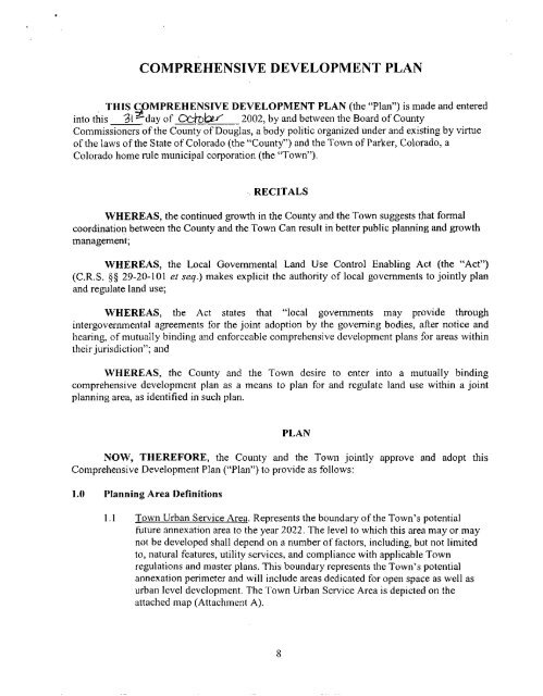
COMPREHENSIVE DEVELOPMENT PLAN<br />
THIS COMPREHENSIVE DEVELOPMENT PLAN (the “Plan”) is made and entered<br />
into this 31 &day of 02bkEf 2002, by and between the Board of <strong>County</strong><br />
Commissioners of the <strong>County</strong> of <strong>Douglas</strong>, a body politic organized under and existing by virtue<br />
of the laws of the State of Colorado (the “<strong>County</strong>”) and the Town of Parker, Colorado, a<br />
Colorado home rule municipal corporation (the “Town”).<br />
RECITALS<br />
WHEREAS, the continued growth in the <strong>County</strong> and the Town suggests that formal<br />
coordination between the <strong>County</strong> and the Town Can result in better public planning and growth<br />
management;<br />
WHEREAS, the Local Governmental Land Use Control Enabling Act (the “Act”)<br />
(C.R.S. $5 29-20-101 et seq.) makes explicit the authority of local govemments to jointly plan<br />
and regulate land use;<br />
WHEREAS, the Act states that “local govemments may provide through<br />
intergovemmenlal agreements for the joint adoption by the goveming bodies, after notice and<br />
hearing, of mutually binding and enforceable comprehensive development plans for areas within<br />
their jurisdiction”; and<br />
WHEREAS, the <strong>County</strong> and the Town desire to enter into a mutually binding<br />
comprehensive development plan as a means to plan for and regulate land use within a joint<br />
planning area, as identified in such plan.<br />
PLAN<br />
NOW, THEREFORE, the <strong>County</strong> and the Town jointly approve and adopt this<br />
Comprehensive Development Plan (“Plan”) to provide as follows:<br />
1.0 Planning Area Definitions<br />
I. I Town Urban Service Area. Represents the boundary of the Town’s potential<br />
future annexation area to the year 2022. The level to which this area may or may<br />
not be developed shall depend on a number of factors, including, but not limited<br />
to, natural features, utility services, and compliance with applicable Town<br />
regulations and master plans. This boundary represents the Town’s potential<br />
annexation perimeter and will include areas dedicated for open space as well as<br />
urban level development. The Town Urban Service Area is depicted on the<br />
attached map (Attachment A).<br />
8
![106 [7.3Mbs] - Douglas County](https://img.yumpu.com/5716620/1/190x245/106-73mbs-douglas-county.jpg?quality=85)