

Development of Deep Aquifer Database and Preliminary Deep ...
Development of Deep Aquifer Database and Preliminary Deep ...
Development of Deep Aquifer Database and Preliminary Deep ...

Create successful ePaper yourself
Turn your PDF publications into a flip-book with our unique Google optimized e-Paper software.
PDF<br />
Documents<br />
Complete<br />
Click Here & Upgrade<br />
Exp<strong>and</strong>ed Features<br />
Unlimited Pages<br />
<strong>Development</strong> <strong>of</strong> <strong>Deep</strong> <strong>Aquifer</strong> <strong>Database</strong> <strong>and</strong><br />
<strong>Preliminary</strong> <strong>Deep</strong> <strong>Aquifer</strong> Mapping<br />
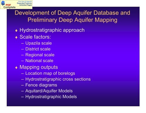
♦ Hydrostratigraphic approach<br />
♦ Scale factors:<br />
– Upazila scale<br />
– District scale<br />
– Regional scale<br />
– National scale<br />
♦ Mapping outputs<br />
– Location map <strong>of</strong> borelogs<br />
– Hydrostratigraphic cross sections<br />
– Fence diagrams<br />
– Aquitard/<strong>Aquifer</strong> Models<br />
– Hydrostratigraphic Models
PDF<br />
Documents<br />
Complete<br />
Click Here & Upgrade<br />
Exp<strong>and</strong>ed Features<br />
Unlimited Pages<br />
Data Coverage in Southern Bangladesh
PDF<br />
Documents<br />
Hydrostratigraphy <strong>of</strong> the Kushtia-Jessore-Khulna Region<br />
Complete<br />
Click Here & Upgrade<br />
Exp<strong>and</strong>ed Features<br />
Unlimited Pages
PDF<br />
Documents<br />
Complete<br />
Click Here & Upgrade<br />
Exp<strong>and</strong>ed Features<br />
Unlimited Pages<br />
Khulna Region Fence Diagram
PDF<br />
Documents<br />
Complete<br />
Click Here & Upgrade<br />
Exp<strong>and</strong>ed Features<br />
Unlimited Pages<br />
Khulna Region Hydrostratigraphic Model
PDF<br />
Documents<br />
Complete<br />
Click Here & Upgrade<br />
Exp<strong>and</strong>ed Features<br />
Unlimited Pages<br />
Depth to the Aquitard 2 in the Southern Region
PDF<br />
Documents<br />
Complete<br />
Click Here & Upgrade<br />
Exp<strong>and</strong>ed Features<br />
Unlimited Pages<br />
Thickness <strong>of</strong> the Aquitard
PDF<br />
Documents<br />
Complete<br />
Click Here & Upgrade<br />
Exp<strong>and</strong>ed Features<br />
Unlimited Pages<br />
Hydrogeological setting <strong>of</strong> Bangladesh: Major Regions<br />
89 90 91 92<br />
26<br />
Zone I<br />
26<br />
INDIA<br />
25<br />
Zone III<br />
Zone IV<br />
25<br />
24<br />
23<br />
INDIA<br />
(W e s t B e n g a l)<br />
Zone III<br />
A<br />
Zone II<br />
Zone V<br />
INDIA<br />
B<br />
Zone VI<br />
24<br />
23<br />
22<br />
22<br />
B a y o f B e n g a l<br />
21<br />
21<br />
89 90 91 92
PDF<br />
Documents<br />
Complete<br />
Click Here & Upgrade<br />
Exp<strong>and</strong>ed Features<br />
Unlimited Pages<br />
Hydrogeological setting <strong>of</strong> Bangladesh: <strong>Aquifer</strong> System<br />
UNDP,<br />
1982<br />
BGS<br />
DPHE,<br />
2001<br />
&<br />
Aggarwal<br />
et al.,<br />
2001<br />
JICA,<br />
2002<br />
GOB, 2002<br />
Arsenic status<br />
Compos<br />
ite<br />
aquifer<br />
Upper<br />
shallow<br />
aquifer<br />
1 st aquifer Shallow<br />
aquifer<br />
(1 st<br />
aquifer)<br />
Upper<br />
Holocene<br />
aquifer<br />
Shallowest part<br />
uncontaminated; lower<br />
part contaminated<br />
Middle<br />
Holocene<br />
aquifer<br />
Most severely<br />
contaminated, peak<br />
arsenic concentrations<br />
occur here<br />
Main<br />
aquifer<br />
Lower<br />
shallow<br />
aquifer<br />
2 nd<br />
aquifer<br />
Middle<br />
aquifer<br />
(2 nd<br />
aquifer)<br />
Lower<br />
Holocene<br />
aquifer<br />
Least contaminated<br />
<strong>Deep</strong><br />
aquifer<br />
<strong>Deep</strong><br />
aquifer<br />
3 rd aquifer <strong>Deep</strong><br />
aquifer<br />
(3 rd<br />
aquifer)<br />
Plio-<br />
Pleistocen<br />
e aquifer<br />
Uncontaminated
PDF<br />
Documents<br />
Complete<br />
Click Here & Upgrade<br />
Exp<strong>and</strong>ed Features<br />
Unlimited Pages<br />
Groundwater Modeling <strong>of</strong> the Bengal<br />
Delta<br />
Holly Michael <strong>and</strong> Clifford Voss<br />
U.S. Geological Survey<br />
Groups from Bangladesh: DU/BUET, DPHE, BWDB<br />
Group from West Bengal: SSCBM, Kolkata, West Bengal<br />
One Regional Model<br />
Three Sub-regional Model in Bangladesh (Dhaka city, SW, SE)<br />
Two Sub-regional Model in West Bengal
PDF<br />
Documents<br />
Complete<br />
Click Here & Upgrade<br />
Exp<strong>and</strong>ed Features<br />
Unlimited Pages<br />
Towards Groundwater Management:<br />
Sustainability <strong>of</strong> As-free water supply?<br />
Apply Calibrated Model to<br />
evaluate alternative pumping schemes<br />
– Criteria<br />
• location <strong>of</strong> recharge (arsenic-free area?)<br />
• travel time (if from arsenic area)<br />
– 3 Pumping schemes<br />
• All Shallow (actual state)<br />
• All <strong>Deep</strong> (current management direction)<br />
• Shallow Irrigation Pumping, <strong>Deep</strong> Domestic Pumping
PDF<br />
Documents<br />
Shallow pumping everywhere current state<br />
Complete<br />
Click Here & Upgrade<br />
Exp<strong>and</strong>ed Features<br />
Unlimited Pages<br />
head (m)<br />
Wells screened at 20-60m depth
PDF<br />
Documents<br />
<strong>Deep</strong> pumping In high-As risk areas<br />
Complete<br />
Click Here & Upgrade<br />
Exp<strong>and</strong>ed Features<br />
Unlimited Pages<br />
head (m)<br />
Wells screened at ~230-270m depth
PDF<br />
Documents<br />
Shallow irrigation pumping<br />
<strong>Deep</strong> domestic pumping in high-As risk areas<br />
Complete<br />
Click Here & Upgrade<br />
Exp<strong>and</strong>ed Features<br />
Unlimited Pages<br />
head (m)
PDF<br />
Documents<br />
Complete<br />
Click Here & Upgrade<br />
Exp<strong>and</strong>ed Features<br />
Unlimited Pages<br />
Conclusions<br />
♦ Management <strong>of</strong> arsenic rich groundwater is a big challenge<br />
for Bangladesh;<br />
♦ Groundwater has been the major source <strong>of</strong> safe drinking<br />
water <strong>and</strong> irrigation; would remain so in the coming years;<br />
♦ Proper groundwater management is needed along with<br />
national water quality monitoring <strong>and</strong> surveillance;<br />
♦ Concepts <strong>of</strong> safe drinking water rather than arsenic safe<br />
drinking water has to be adopted;<br />
♦ While introducing a new source,care should be taken to avoid<br />
possible risk substitution;<br />
♦ Arsenic mitigation should be made part <strong>of</strong> the overall water<br />
resources management;<br />
♦ Capacity building at local, regional <strong>and</strong> national scale.
PDF<br />
Documents<br />
Complete<br />
Click Here & Upgrade<br />
Exp<strong>and</strong>ed Features<br />
Unlimited Pages<br />
Acknowledgements<br />
♦ Colleagues <strong>and</strong> Students at the Department<br />
<strong>of</strong> Geology, University <strong>of</strong> Dhaka<br />
♦ Organizations in Bangladesh such as DPHE,<br />
BWDB<br />
♦ Research Collaborators from:<br />
– LDEO, CU<br />
– USGS<br />
– UCL (UK)<br />
– KTH (Sweden)
PDF<br />
Documents<br />
Complete<br />
Click Here & Upgrade<br />
Exp<strong>and</strong>ed Features<br />
Unlimited Pages<br />
Dhanyabad<br />
Thank You All