Gulfport SmartCode - Mississippi Renewal
Gulfport SmartCode - Mississippi Renewal
Gulfport SmartCode - Mississippi Renewal

You also want an ePaper? Increase the reach of your titles
YUMPU automatically turns print PDFs into web optimized ePapers that Google loves.
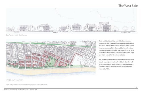
The West Side<br />
Broad Avenue - North - South Transect<br />
These neighborhoods, lying west of the Downtown and<br />
between the beach and the CSX Railroad, were hit very hard<br />
by Katrina. In most of this area, the first block or two nearest<br />
the shore were completely destroyed, leaving only mature<br />
trees and building foundations. The next block or two north<br />
of this destruction were also badly damaged, by water, wind<br />
and debris pushed from the shoreline blocks.<br />
The preliminary flood surface elevation maps for West Beach<br />
include new, higher elevations for habitable floors in much<br />
of the frontage along Beach Boulevard. Not coincidentally,<br />
the destruction was generally greatest in these new areas<br />
mapped by FEMA.<br />
West Side Neighborhood Detail<br />
Note: This Page edited from the December 2005 <strong>Mississippi</strong> <strong>Renewal</strong> Forum Charrette Report<br />
24<br />
<strong>SmartCode</strong> Charrette Book • <strong>Gulfport</strong>, <strong>Mississippi</strong> • February 2006