- Page 1:
*TM 1-1520-251-10 TECHNICAL MANUAL
- Page 4 and 5:
TM 1-1520-251-10 WARNING FIRE EXTIN
- Page 7:
TM 1-1520-251-10 C5 CHANGE } NO. 5
- Page 10 and 11:
TM 1-1520-251-10 C4 Remove pages In
- Page 13 and 14:
TM 1-1520-251-10 C3 CHANGE } NO. 3
- Page 15:
TM 1-1520-251-10 C3 Remove pages In
- Page 18 and 19:
TM 1-1520-251-10 C 2 Remove pages I
- Page 21 and 22:
TM 1-1520-251-10 C 1 CHANGE } NO. 1
- Page 23 and 24:
TM 1-1520-251-10 LIST OF EFFECTIVE
- Page 25 and 26:
TM 1-1520-251-10 INSERT LATEST CHAN
- Page 27 and 28:
*TM 1-1520-251-10 Technical Manual
- Page 29 and 30:
TM 1-1520-251-10 TABLE OF CONTENTS
- Page 31 and 32:
TM 1-1520-251-10 CHAPTER 1 INTRODUC
- Page 33 and 34:
TM 1-1520-251-10 CHAPTER 2 AIRCRAFT
- Page 35 and 36:
TM 1-1520-251-10 17 3 18 20 3 31 3
- Page 37 and 38:
TM 1-1520-251-10 TURNING RADIUS: 37
- Page 39 and 40:
TM 1-1520-251-10 30MM GUN AREA & BL
- Page 41 and 42:
TM 1-1520-251-10 1 2 28 2 29 30 31
- Page 43 and 44:
TM 1-1520-251-10 22 21 23 25 24 26
- Page 45 and 46:
TM 1-1520-251-10 2.15 MAIN LANDING
- Page 47 and 48:
TM 1-1520-251-10 CONTROL AND DISPLA
- Page 49 and 50:
TM 1-1520-251-10 each crew station
- Page 51 and 52:
TM 1-1520-251-10 2.20.6 MPD Bezel P
- Page 53 and 54:
TM 1-1520-251-10 DATA BEGINS AND PA
- Page 55 and 56:
TM 1-1520-251-10 • R5 [ BLK 2 COM
- Page 57 and 58:
TM 1-1520-251-10 • B5 • * • R
- Page 59 and 60:
TM 1-1520-251-10 CURSOR CONTROLLER/
- Page 61 and 62:
TM 1-1520-251-10 Figure 2-28. LBA19
- Page 63 and 64:
TM 1-1520-251-10 scratchpad display
- Page 65 and 66:
ÓÓÓÓÓÓÓÓÓÓÓ ÓÓÓÓÓÓ
- Page 67 and 68:
TM 1-1520-251-10 Placing the TEST s
- Page 69 and 70:
TM 1-1520-251-10 Section III. ENGIN
- Page 71 and 72:
TM 1-1520-251-10 2.38 ACCESSORY SEC
- Page 73 and 74:
TM 1-1520-251-10 Fault codes will b
- Page 75 and 76:
TM 1-1520-251-10 2.45.2 Engine Blee
- Page 77 and 78:
TM 1-1520-251-10 a. ENG Page Instru
- Page 79 and 80:
TM 1-1520-251-10 This text, display
- Page 81 and 82:
TM 1-1520-251-10 Section IV. FUEL S
- Page 83 and 84:
TM 1-1520-251-10 ENG CELL X FEED BR
- Page 85 and 86:
TM 1-1520-251-10 2.60.1 Transfer (X
- Page 87 and 88:
TM 1-1520-251-10 the page and provi
- Page 89 and 90:
TM 1-1520-251-10 2.61A.2 Center AUX
- Page 91 and 92:
TM 1-1520-251-10 Section V. FLIGHT
- Page 93 and 94:
TM 1-1520-251-10 engaged, the magne
- Page 95 and 96:
TM 1-1520-251-10 2.71 STABILITY AND
- Page 97 and 98:
TM 1-1520-251-10 2.72.1 Use of Forc
- Page 99 and 100:
TM 1-1520-251-10 CAUTION In the eve
- Page 101:
TM 1-1520-251-10 (2) Severances. (a
- Page 104 and 105:
TM 1-1520-251-10 Section VI. HYDRAU
- Page 106 and 107:
ÏÏÏÏÏ ÏÏÏÏÏ ÏÏÏÏÏÏ
- Page 108 and 109:
TM 1-1520-251-10 2.81 UTILITY HYDRA
- Page 110 and 111:
TM 1-1520-251-10 ENG INLET ANTI−I
- Page 112 and 113:
TM 1-1520-251-10 2.84.1 Dual Engine
- Page 114 and 115:
TM 1-1520-251-10 2.86.2 Main Transm
- Page 116 and 117:
TM 1-1520-251-10 2.89 ROTOR SYSTEM
- Page 118 and 119:
TM 1-1520-251-10 Section IX. UTILIT
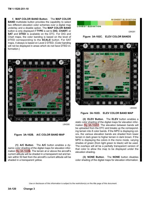
- Page 120 and 121:
TM 1-1520-251-10 Section X. ENVIRON
- Page 122 and 123:
TM 1-1520-251-10 CAUTION To obtain
- Page 124 and 125:
TM 1-1520-251-10 AGPU 1 CIRCUIT BRE
- Page 126 and 127:
TM 1-1520-251-10 • ECS COMP 1 •
- Page 128 and 129:
TM 1-1520-251-10 DC BUS NO. 1 • I
- Page 130 and 131:
TM 1-1520-251-10 BATT BUS NO. 1 BAT
- Page 133 and 134:
TM 1-1520-251-10 2.98.1 [ BLK 1 Cir
- Page 135 and 136:
TM 1-1520-251-10 2.98.2 [ BLK 1 Cir
- Page 137 and 138:
ÔÔ ÔÔ ÔÔ ÔÔ TM 1-1520-251-1
- Page 139 and 140:
TM 1-1520-251-10 2.99 BATTERY The b
- Page 141 and 142:
TM 1-1520-251-10 2.102.1 Generators
- Page 143 and 144:
TM 1-1520-251-10 APU ELECTRONIC CON
- Page 145 and 146:
TM 1-1520-251-10 2.106.1 Formation
- Page 147 and 148:
TM 1-1520-251-10 2.108.4 Signal Lig
- Page 149 and 150:
TM 1-1520-251-10 4. Lubber Line. Th
- Page 151 and 152:
TM 1-1520-251-10 20 Ground Speed. G
- Page 153 and 154:
TM 1-1520-251-10 It can also be use
- Page 155 and 156:
TM 1-1520-251-10 Section XV. SERVIC
- Page 157 and 158:
TM 1-1520-251-10 OIL LEVEL FULL SIG
- Page 159 and 160:
TM 1-1520-251-10 FUEL QTY IND ON FU
- Page 162 and 163:
TM 1-1520-251-10 Table 2-9. Fuel an
- Page 164 and 165:
TM 1-1520-251-10 Table 2-11. Approv
- Page 166 and 167:
TM 1-1520-251-10 2.114.6 Rapid Refu
- Page 168 and 169:
TM 1-1520-251-10 or b. Single engin
- Page 170 and 171:
TM 1-1520-251-10 TADS/PNVS PROTECTI
- Page 172 and 173:
TM 1-1520-251-10 Section XVI. DATA
- Page 174 and 175:
TM 1-1520-251-10 Table 2-12. DTC Up
- Page 176 and 177:
TM 1-1520-251-10 2.128.5 UTIL. The
- Page 178 and 179:
TM 1-1520-251-10 i. [ BLK 2 DTU Con
- Page 180 and 181:
TM 1-1520-251-10 2.129.11 [ BLK 2 D
- Page 183 and 184:
TM 1-1520-251-10 The following uniq
- Page 185:
TM 1-1520-251-10 2.128.18A AVIONICS
- Page 188 and 189:
TM 1-1520-251-10 The following uniq
- Page 190 and 191:
TM 1-1520-251-10 2.131.1 COMM RADIO
- Page 192 and 193:
TM 1-1520-251-10 2.131A.4 PNVS butt
- Page 194 and 195:
TM 1-1520-251-10 Figure 2-126A. [ B
- Page 196 and 197:
TM 1-1520-251-10 2.135 WCA OPERATIO
- Page 198 and 199:
TM 1-1520-251-10 order of occurrenc
- Page 200 and 201:
TM 1-1520-251-10 UFD TEXT EUFD TEXT
- Page 202 and 203:
TM 1-1520-251-10 UFD TEXT EUFD TEXT
- Page 204 and 205:
TM 1-1520-251-10 UFD TEXT EUFD TEXT
- Page 206:
TM 1-1520-251-10 UFD TEXT EUFD TEXT
- Page 209 and 210:
TM 1-1520-251-10 EFABS HOT UFD TEXT
- Page 211 and 212:
TM 1-1520-251-10 UFD TEXT EUFD TEXT
- Page 213 and 214:
TM 1-1520-251-10 UFD TEXT EUFD TEXT
- Page 215 and 216:
TM 1-1520-251-10 UFD TEXT EUFD TEXT
- Page 217 and 218:
TM 1-1520-251-10 UFD TEXT EUFD TEXT
- Page 219 and 220:
TM 1-1520-251-10 UFD TEXT EUFD TEXT
- Page 221 and 222:
TM 1-1520-251-10 UFD TEXT EUFD TEXT
- Page 223 and 224:
TM 1-1520-251-10 2.140 TESS ADVISOR
- Page 225 and 226:
TM 1-1520-251-10 CHAPTER 3 BLK 1 AV
- Page 227 and 228:
TM 1-1520-251-10 Table 3-1. Communi
- Page 229 and 230:
TM 1-1520-251-10 1 2 3 11 9 5 6 7 8
- Page 231 and 232:
TM 1-1520-251-10 3.5 ARC-186(V) VHF
- Page 233 and 234:
TM 1-1520-251-10 3.7.6 VCR Selectio
- Page 235 and 236:
TM 1-1520-251-10 3.12 IMPROVED DATA
- Page 237 and 238:
TM 1-1520-251-10 GUARD EMERGENCY XP
- Page 239 and 240:
TM 1-1520-251-10 Buttons on the COM
- Page 241 and 242:
TM 1-1520-251-10 Figure 3-11. Figur
- Page 243 and 244:
TM 1-1520-251-10 3.26.7 PRESET VHF,
- Page 245 and 246:
TM 1-1520-251-10 available for TACF
- Page 247 and 248:
TM 1-1520-251-10 3.29 IMPROVED DATA
- Page 249 and 250:
TM 1-1520-251-10 3.31 CURRENT MISSI
- Page 251 and 252:
TM 1-1520-251-10 3.33.3 XMSN AUTH I
- Page 253 and 254:
TM 1-1520-251-10 LBA0410A LBA5209 F
- Page 255 and 256:
TM 1-1520-251-10 3.35.14 ERF RECEIV
- Page 257 and 258:
TM 1-1520-251-10 The ERF SEND page
- Page 259 and 260:
TM 1-1520-251-10 3.38.5 TOD GPS TIM
- Page 261 and 262:
TM 1-1520-251-10 3.42.5 UPDATE Butt
- Page 263 and 264:
TM 1-1520-251-10 3.44.10 REPLY Butt
- Page 265 and 266:
TM 1-1520-251-10 3.46.1 FALL BACK E
- Page 267 and 268:
TM 1-1520-251-10 3.47.4 Receive TOD
- Page 269 and 270:
TM 1-1520-251-10 8. If hopset data
- Page 271 and 272:
TM 1-1520-251-10 3.52 TO TRANSMIT L
- Page 273 and 274:
TM 1-1520-251-10 selected. Differen
- Page 275 and 276:
TM 1-1520-251-10 LBA3044A Figure 3-
- Page 277 and 278:
TM 1-1520-251-10 LBA3046A Figure 3-
- Page 279 and 280:
TM 1-1520-251-10 (2) STORING / SEND
- Page 281 and 282:
TM 1-1520-251-10 27. (D) - CMD line
- Page 283 and 284:
TM 1-1520-251-10 3.53.6 MOVEMENT CO
- Page 285 and 286:
TM 1-1520-251-10 6. Target type - P
- Page 287 and 288:
TM 1-1520-251-10 3.53.9 FREE TEXT/P
- Page 289 and 290:
TM 1-1520-251-10 3.53.10 RECEIVED M
- Page 291 and 292:
TM 1-1520-251-10 Section IIA. HF CO
- Page 293 and 294:
TM 1-1520-251-10 3.53E AN/ARC-201D
- Page 295 and 296:
TM 1-1520-251-10 is limited to A or
- Page 297 and 298:
TM 1-1520-251-10 • Single Hopset
- Page 299 and 300:
TM 1-1520-251-10 EUFD communication
- Page 301 and 302:
TM 1-1520-251-10 d. HF radio e. HQ1
- Page 303 and 304:
TM 1-1520-251-10 3.53W.2 SOI Page B
- Page 305 and 306:
TM 1-1520-251-10 3.53Y.1 NET Page B
- Page 307 and 308:
TM 1-1520-251-10 3.53Z.8 HF RECV EM
- Page 309 and 310:
TM 1-1520-251-10 3.53AA.4 PRESET RA
- Page 311 and 312:
TM 1-1520-251-10 3.53AB.15 EDIT FM1
- Page 313 and 314:
TM 1-1520-251-10 When the TACFIRE b
- Page 315 and 316:
TM 1-1520-251-10 NOTE Selecting the
- Page 317 and 318:
TM 1-1520-251-10 The NET (LONGBOW,
- Page 319 and 320:
TM 1-1520-251-10 The SUFFX page con
- Page 321 and 322:
TM 1-1520-251-10 • T2 RVW button
- Page 323 and 324:
TM 1-1520-251-10 3.53AG.2 MISSION 1
- Page 325 and 326:
TM 1-1520-251-10 3.53AH.2 AREAS But
- Page 327 and 328:
TM 1-1520-251-10 3.53AK.2 PRESET DI
- Page 329 and 330:
TM 1-1520-251-10 Figure 3-62AQ. 3.5
- Page 331 and 332:
TM 1-1520-251-10 3.53AN.3 TONE Butt
- Page 333 and 334:
TM 1-1520-251-10 3.53AR.2 FM MODE B
- Page 335 and 336:
TM 1-1520-251-10 3.53AS.1 RECEIVE B
- Page 337 and 338:
TM 1-1520-251-10 LBA5140 LBA5141 Fi
- Page 339 and 340:
TM 1-1520-251-10 3.53AT.2 HF MODE B
- Page 341 and 342:
TM 1-1520-251-10 3.53AX HF PAGE - A
- Page 343 and 344:
TM 1-1520-251-10 3.53BB HF CALL ADD
- Page 345 and 346:
TM 1-1520-251-10 3.53BC HF SET PAGE
- Page 347 and 348:
TM 1-1520-251-10 3.53BE ARC-164 HAV
- Page 349 and 350:
TM 1-1520-251-10 3.53BG.1 Automatic
- Page 351 and 352:
TM 1-1520-251-10 3.53BH.2 SET CRYPT
- Page 353 and 354:
TM 1-1520-251-10 Table 3-3C. Messag
- Page 355 and 356:
TM 1-1520-251-10 Table 3-3D. To Tra
- Page 357 and 358:
TM 1-1520-251-10 available lines re
- Page 359 and 360:
TM 1-1520-251-10 3.53BI.4 AIR REQUE
- Page 361 and 362:
TM 1-1520-251-10 OBSERVER LAUNCHER
- Page 363 and 364:
TM 1-1520-251-10 7. D) TARGET type
- Page 365 and 366:
TM 1-1520-251-10 e. New Artillery F
- Page 367 and 368:
TM 1-1520-251-10 6. BDA/CAS button
- Page 369 and 370:
TM 1-1520-251-10 e. Weapons/Present
- Page 371 and 372:
TM 1-1520-251-10 f. Cancel Checkfir
- Page 373 and 374:
TM 1-1520-251-10 Section III. NAVIG
- Page 375 and 376:
TM 1-1520-251-10 3.55.1 Global Posi
- Page 377 and 378:
TM 1-1520-251-10 3.56 AN/ASN-157 DO
- Page 379 and 380:
TM 1-1520-251-10 3.61.11 Cursor Acq
- Page 381 and 382:
TM 1-1520-251-10 3.61.29 Endurance
- Page 383 and 384:
TM 1-1520-251-10 3.62.16 Shot- At I
- Page 385 and 386:
TM 1-1520-251-10 status of INU1 and
- Page 387 and 388:
TM 1-1520-251-10 3.65 ADF PAGE NOTE
- Page 389 and 390:
TM 1-1520-251-10 3.66.5 FREQ Button
- Page 391 and 392:
TM 1-1520-251-10 Table 3-9. Abbrevi
- Page 393 and 394:
TM 1-1520-251-10 Table 3-13. Abbrev
- Page 395 and 396:
TM 1-1520-251-10 3.68.2 SHOW Page -
- Page 397 and 398:
TM 1-1520-251-10 (1) Waypoint (WP)
- Page 399 and 400:
TM 1-1520-251-10 3.71.3 Delete (DEL
- Page 401 and 402:
TM 1-1520-251-10 LBA1929A LBA2546A
- Page 403 and 404:
TM 1-1520-251-10 LBA5226 LBA5227 Fi
- Page 405 and 406:
TM 1-1520-251-10 3.80 FUEL, AMMO, R
- Page 407 and 408:
TM 1-1520-251-10 Figure 3-88. ZN (Z
- Page 409 and 410:
TM 1-1520-251-10 3.81.9 SELECT (SEL
- Page 411 and 412:
TM 1-1520-251-10 3.82.1 Battle Dama
- Page 413 and 414:
TM 1-1520-251-10 2. STO button - Se
- Page 415 and 416:
TM 1-1520-251-10 CHAPTER 3A BLK 2 A
- Page 417 and 418:
TM 1-1520-251-10 Table 3A-1. Commun
- Page 419 and 420:
TM 1-1520-251-10 1 2 3 11 9 5 6 7 8
- Page 421 and 422:
TM 1-1520-251-10 3A.5 ARC-186(V) VH
- Page 423 and 424:
TM 1-1520-251-10 Table 3A-3. Adviso
- Page 425 and 426:
TM 1-1520-251-10 CAUTION Failure to
- Page 427 and 428:
TM 1-1520-251-10 Single Hopset/Lock
- Page 429 and 430:
TM 1-1520-251-10 3A.17.5 ICS Mode S
- Page 431 and 432:
TM 1-1520-251-10 COM IDM XPNDR UHF
- Page 433 and 434:
TM 1-1520-251-10 3A.23 COMMUNICATIO
- Page 435 and 436:
TM 1-1520-251-10 Figure 3A-9. LBA50
- Page 437 and 438:
TM 1-1520-251-10 Tacfire Team ID. T
- Page 439 and 440:
TM 1-1520-251-10 • L5 • L6 •
- Page 441:
TM 1-1520-251-10 3A.27.3 COM PRESET
- Page 444 and 445:
TM 1-1520-251-10 3A.28.9 HF XMIT FR
- Page 446 and 447:
TM 1-1520-251-10 NOTE An ALL CODES
- Page 449 and 450:
TM 1-1520-251-10 NOTE TI and FS pre
- Page 451 and 452:
TM 1-1520-251-10 3A.30.7 EDIT VHF F
- Page 453 and 454:
TM 1-1520-251-10 3A.31.3 TACFIRE PR
- Page 455 and 456:
TM 1-1520-251-10 LBA5100 LBA5101 Fi
- Page 457 and 458:
TM 1-1520-251-10 NOTE Selecting the
- Page 459 and 460:
TM 1-1520-251-10 The NET (LONGBOW,
- Page 461 and 462:
TM 1-1520-251-10 3A.33.15 MEMBER St
- Page 463 and 464:
TM 1-1520-251-10 3A.34.7 SRCH Butto
- Page 465 and 466:
TM 1-1520-251-10 Figure 3A-38. NOTE
- Page 467 and 468:
TM 1-1520-251-10 3A.35.16 DEL Butto
- Page 469 and 470:
TM 1-1520-251-10 3A.37.1 WAYPOINTS
- Page 471 and 472:
TM 1-1520-251-10 The TEXT page cont
- Page 473 and 474:
TM 1-1520-251-10 NOTE Due to the AP
- Page 475 and 476:
TM 1-1520-251-10 3A.42A XPNDR PAGE
- Page 477 and 478:
TM 1-1520-251-10 3A.44 UHF WOD PAGE
- Page 479 and 480:
TM 1-1520-251-10 FM FH/M (Frequency
- Page 481 and 482:
TM 1-1520-251-10 3A.48.2 SEND Butto
- Page 483 and 484:
TM 1-1520-251-10 LBA5141 LBA5142 Fi
- Page 485 and 486:
TM 1-1520-251-10 3A.50 HF SELF ADDR
- Page 487 and 488:
TM 1-1520-251-10 3A.53.7 ALE Status
- Page 489 and 490:
TM 1-1520-251-10 Figure 3A-81. LBA5
- Page 491 and 492:
TM 1-1520-251-10 3A.58.4 HF POWER B
- Page 493 and 494:
TM 1-1520-251-10 3A.60 ARC-164 HAVE
- Page 495 and 496:
TM 1-1520-251-10 3A.62.1 Automatic
- Page 497 and 498:
TM 1-1520-251-10 3A.63.2 SET CRYPTO
- Page 499 and 500:
TM 1-1520-251-10 3A.64 TRANSMITTING
- Page 501 and 502:
TM 1-1520-251-10 Table 3A-4. Messag
- Page 503 and 504:
TM 1-1520-251-10 Table 3A-4A. To tr
- Page 505 and 506:
TM 1-1520-251-10 Table 3A-4D. To Tr
- Page 507 and 508:
TM 1-1520-251-10 The IDM TACFIRE pa
- Page 509 and 510: TM 1-1520-251-10 NOTE • All artil
- Page 511 and 512: TM 1-1520-251-10 operator interface
- Page 513 and 514: TM 1-1520-251-10 3A.71.13 AIR MSNS
- Page 515 and 516: TM 1-1520-251-10 3A.71.17 MOVEMENT
- Page 517 and 518: TM 1-1520-251-10 • R3 XX-FAT
- Page 519 and 520: TM 1-1520-251-10 3A.71.23 Target/Po
- Page 521 and 522: TM 1-1520-251-10 SHOOTER: (REMOTE H
- Page 523 and 524: TM 1-1520-251-10 c. Review Fire Con
- Page 525 and 526: TM 1-1520-251-10 f. Review/change T
- Page 527 and 528: TM 1-1520-251-10 b. Enter Time On T
- Page 529 and 530: TM 1-1520-251-10 25. Status (L3) wi
- Page 531 and 532: TM 1-1520-251-10 (6) Press 1/1 (R1)
- Page 533 and 534: TM 1-1520-251-10 3A.71.36 Fire Miss
- Page 535 and 536: TM 1-1520-251-10 Selecting an activ
- Page 537 and 538: TM 1-1520-251-10 3A.71.43 Aircraft
- Page 539 and 540: TM 1-1520-251-10 5. DTU door - Latc
- Page 541 and 542: TM 1-1520-251-10 3A.73 EMBEDDED GLO
- Page 543 and 544: TM 1-1520-251-10 Table 3A-6. |Datum
- Page 545 and 546: TM 1-1520-251-10 • T1 • T2 •
- Page 547 and 548: TM 1-1520-251-10 • FREE TEXT TAC
- Page 549 and 550: TM 1-1520-251-10 3A.79.29 Next Wayp
- Page 551: TM 1-1520-251-10 3A.80.2 Route Line
- Page 554 and 555: TM 1-1520-251-10 • 50km; FCR Prio
- Page 556 and 557: TM 1-1520-251-10 date data. The TSD
- Page 558 and 559: TM 1-1520-251-10 3A.81.14 SATELLITE
- Page 562 and 563: TM 1-1520-251-10 Table 3A-6B. Found
- Page 564 and 565: TM 1-1520-251-10 best scale for the
- Page 566 and 567: TM 1-1520-251-10 b. PITCH Entry But
- Page 568 and 569: TM 1-1520-251-10 Figure 3A-105. INS
- Page 570 and 571: TM 1-1520-251-10 Table 3A-9. Abbrev
- Page 572 and 573: TM 1-1520-251-10 Table 3A-13. Abbre
- Page 574 and 575: TM 1-1520-251-10 3A.87.2 SHOW Page
- Page 576 and 577: TM 1-1520-251-10 a. ASE THREATS But
- Page 578 and 579: TM 1-1520-251-10 c. ENEMY UNITS But
- Page 580 and 581: TM 1-1520-251-10 3A.89.5 Store (STO
- Page 582 and 583: TM 1-1520-251-10 3A.90.3 Delete (DE
- Page 584 and 585: TM 1-1520-251-10 3A.92 COORDINATE (
- Page 586 and 587: TM 1-1520-251-10 3A.95 LINE PAGE Th
- Page 588 and 589: TM 1-1520-251-10 3A.98 FUEL, AMMO,
- Page 590 and 591: TM 1-1520-251-10 3A.99.1 Active (AC
- Page 592 and 593: TM 1-1520-251-10 3A.99.7 SELECT (SE
- Page 594 and 595: TM 1-1520-251-10 3A.100.2 Battle Da
- Page 596 and 597: TM 1-1520-251-10 3A.100.8 Subscribe
- Page 598 and 599: TM 1-1520-251-10 NOTE Low priority
- Page 600 and 601: TM 1-1520-251-10 transmitted and re
- Page 602 and 603: TM 1-1520-251-10 3A.102.2 Store a W
- Page 604 and 605: TM 1-1520-251-10 3A.102.8 Transmit
- Page 606 and 607: TM 1-1520-251-10 h. Transmit Check
- Page 608 and 609: TM 1-1520-251-10 NOTE The TSD-RPT-A
- Page 610 and 611:
ÑÑÑÑ ÑÑÑÑ TM 1-1520-251-10
- Page 612 and 613:
TM 1-1520-251-10 4.5.4 FCR Scan Siz
- Page 614 and 615:
TM 1-1520-251-10 The WPN UTIL page
- Page 616 and 617:
TM 1-1520-251-10 • L1 • L2 •
- Page 619 and 620:
TM 1-1520-251-10 4.11 IHADSS DESCRI
- Page 621 and 622:
TM 1-1520-251-10 4.14 FLIGHT SYMBOL
- Page 623 and 624:
TM 1-1520-251-10 15. Additional Sym
- Page 625 and 626:
TM 1-1520-251-10 4. Barometric or I
- Page 627:
TM 1-1520-251-10 d. Missile Constra
- Page 630 and 631:
TM 1-1520-251-10 Table 4-1. HAD Sig
- Page 632 and 633:
TM 1-1520-251-10 Table 4-1. HAD Sig
- Page 634 and 635:
TM 1-1520-251-10 Table 4-4. Weapon
- Page 636 and 637:
TM 1-1520-251-10 Table 4-5. HAD Wea
- Page 638 and 639:
TM 1-1520-251-10 4.16.7 HMD FORMAT
- Page 640 and 641:
TM 1-1520-251-10 Subsequently selec
- Page 643 and 644:
TM 1-1520-251-10 4.21 OPTICAL RELAY
- Page 645 and 646:
TM 1-1520-251-10 Table 4-8. Sight S
- Page 647 and 648:
TM 1-1520-251-10 Table 4-11. Weapon
- Page 649 and 650:
TM 1-1520-251-10 4.23.1 BORESIGHT E
- Page 651 and 652:
TM 1-1520-251-10 4.26.1 Manual Trac
- Page 653 and 654:
TM 1-1520-251-10 6. Low Confidence
- Page 655 and 656:
TM 1-1520-251-10 RADOME AFT DOME RF
- Page 657 and 658:
TM 1-1520-251-10 A view of all scan
- Page 659 and 660:
TM 1-1520-251-10 right area of the
- Page 661 and 662:
TM 1-1520-251-10 POSITION OF MAIN B
- Page 663 and 664:
TM 1-1520-251-10 A view of all scan
- Page 665 and 666:
TM 1-1520-251-10 4.35.15 FCR Page -
- Page 667 and 668:
TM 1-1520-251-10 4.36 FCR UTIL PAGE
- Page 669 and 670:
TM 1-1520-251-10 4.37 FCR OPERATION
- Page 671 and 672:
TM 1-1520-251-10 b. Profile Lines.
- Page 673 and 674:
TM 1-1520-251-10 e. ATM Wiper Symbo
- Page 675 and 676:
TM 1-1520-251-10 4.44.5 Priority of
- Page 677 and 678:
TM 1-1520-251-10 4.45.4 RFI Detecte
- Page 679 and 680:
TM 1-1520-251-10 4.47.2 Sight Selec
- Page 681 and 682:
TM 1-1520-251-10 Table 4-20. Sight
- Page 683 and 684:
TM 1-1520-251-10 4.49 RANGE AND RAN
- Page 685 and 686:
TM 1-1520-251-10 4.50.10 Degraded F
- Page 687 and 688:
TM 1-1520-251-10 4.52 CONTROLS AND
- Page 689 and 690:
TM 1-1520-251-10 4.53.6 DISPLAY But
- Page 691 and 692:
TM 1-1520-251-10 4.54.4 [ BLK 1 TAP
- Page 693 and 694:
TM 1-1520-251-10 Prior to shut-down
- Page 695 and 696:
TM 1-1520-251-10 4.54A.9 STORE Butt
- Page 697 and 698:
TM 1-1520-251-10 7. Sensor Select s
- Page 699 and 700:
TM 1-1520-251-10 4.55.5A TADS Manua
- Page 701 and 702:
TM 1-1520-251-10 g. On TDU, observe
- Page 703 and 704:
TM 1-1520-251-10 NOTE Reticle shoul
- Page 705 and 706:
TM 1-1520-251-10 4.55.10A TADS Outf
- Page 707 and 708:
TM 1-1520-251-10 Section II. ARMAME
- Page 709 and 710:
TM 1-1520-251-10 LBA2559 Figure 4-6
- Page 711 and 712:
TM 1-1520-251-10 N Z W • RKT (Roc
- Page 713 and 714:
TM 1-1520-251-10 e. Gun FAIL Indica
- Page 715 and 716:
TM 1-1520-251-10 SAL 1 LASER MISSIL
- Page 717 and 718:
TM 1-1520-251-10 MISSILE LAUNCHER P
- Page 719 and 720:
TM 1-1520-251-10 LBA0432 4.64.7 Cas
- Page 721 and 722:
TM 1-1520-251-10 4.66 MISSILE CHANN
- Page 723 and 724:
TM 1-1520-251-10 set-up and shut-do
- Page 725 and 726:
TM 1-1520-251-10 4.73 LONGBOW HELLF
- Page 727 and 728:
TM 1-1520-251-10 4.75 TACTICAL ENGA
- Page 729 and 730:
TM 1-1520-251-10 • The TTM will p
- Page 731 and 732:
TM 1-1520-251-10 4.78.2 M230E1, 30m
- Page 733 and 734:
TM 1-1520-251-10 5. ALT button - Se
- Page 735 and 736:
TM 1-1520-251-10 4.80.9 RFI Only Op
- Page 737 and 738:
TM 1-1520-251-10 4.82 AN/APR-39A(V)
- Page 739 and 740:
TM 1-1520-251-10 the phase interfer
- Page 741 and 742:
TM 1-1520-251-10 Jam Program Select
- Page 743 and 744:
TM 1-1520-251-10 4.89.2 ASE Button.
- Page 745 and 746:
TM 1-1520-251-10 4.89.26 Load Maint
- Page 747 and 748:
TM 1-1520-251-10 CHAPTER 5 OPERATIN
- Page 749 and 750:
TM 1-1520-251-10 Figure 5-3. 120% 1
- Page 751 and 752:
TM 1-1520-251-10 999° C 999° C 96
- Page 753 and 754:
TM 1-1520-251-10 130% LIMITS - TORQ
- Page 755 and 756:
TM 1-1520-251-10 Section IV. LOADIN
- Page 757 and 758:
TM 1-1520-251-10 EXAMPLE ON SHEET 2
- Page 759:
TM 1-1520-251-10 FLIGHT ENVELOPE FL
- Page 762 and 763:
TM 1-1520-251-10 BL 98.0 RIGHT EFAB
- Page 764 and 765:
TM 1-1520-251-10 6.2.4 Loading Data
- Page 766 and 767:
TM 1-1520-251-10 Section III. FUEL
- Page 768 and 769:
TM 1-1520-251-10 Table 6-2. Main Ta
- Page 770 and 771:
TM 1-1520-251-10 6-10 Table 6-3. Wi
- Page 772 and 773:
TM 1-1520-251-10 Table 6-3B. Intern
- Page 774 and 775:
TM 1-1520-251-10 Section V. MISSION
- Page 776 and 777:
TM 1-1520-251-10 Table 6-7. 2.75-In
- Page 778 and 779:
TM 1-1520-251-10 Section VI. CARGO
- Page 780 and 781:
TM 1-1520-251-10 Section VII. ALLOW
- Page 783 and 784:
TM 1-1520-251-10 CHAPTER 7 PERFORMA
- Page 785 and 786:
TM 1-1520-251-10 7.2.4 Maximum Gros
- Page 787 and 788:
TM 1-1520-251-10 pressure altitude
- Page 789 and 790:
TM 1-1520-251-10 7.3.4 STORE Button
- Page 791 and 792:
TM 1-1520-251-10 TEMPERATURE CONVER
- Page 793 and 794:
TM 1-1520-251-10 EXAMPLE WANTED TOR
- Page 795 and 796:
TM 1-1520-251-10 TORQUE FACTOR T700
- Page 797 and 798:
TM 1-1520-251-10 Section III. HOVER
- Page 799 and 800:
TM 1-1520-251-10 7.18 DESCRIPTION S
- Page 801 and 802:
TM 1-1520-251-10 7.21 DESCRIPTION S
- Page 803 and 804:
TM 1-1520-251-10 CRUISE PRESSURE AL
- Page 805 and 806:
TM 1-1520-251-10 CRUISE PRESSURE AL
- Page 807 and 808:
TM 1-1520-251-10 CRUISE PRESSURE AL
- Page 809 and 810:
TM 1-1520-251-10 CRUISE PRESSURE AL
- Page 811 and 812:
TM 1-1520-251-10 CRUISE PRESSURE AL
- Page 813 and 814:
TM 1-1520-251-10 CRUISE PRESSURE AL
- Page 815 and 816:
TM 1-1520-251-10 CRUISE PRESSURE AL
- Page 817 and 818:
TM 1-1520-251-10 CRUISE PRESSURE AL
- Page 819 and 820:
TM 1-1520-251-10 180 170 600 800 10
- Page 821 and 822:
TM 1-1520-251-10 CRUISE PRESSURE AL
- Page 823 and 824:
TM 1-1520-251-10 CRUISE PRESSURE AL
- Page 825 and 826:
TM 1-1520-251-10 180 170 160 FAT =
- Page 827 and 828:
TM 1-1520-251-10 180 170 160 150 14
- Page 829 and 830:
TM 1-1520-251-10 CRUISE PRESSURE AL
- Page 831 and 832:
TM 1-1520-251-10 180 170 160 INDICA
- Page 833 and 834:
TM 1-1520-251-10 CRUISE PRESSURE AL
- Page 835 and 836:
TM 1-1520-251-10 180 170 160 TOTAL
- Page 837 and 838:
TM 1-1520-251-10 CRUISE PRESSURE AL
- Page 839 and 840:
TM 1-1520-251-10 CRUISE PRESSURE AL
- Page 841 and 842:
TM 1-1520-251-10 180 170 160 CRUISE
- Page 843 and 844:
TM 1-1520-251-10 CRUISE PRESSURE AL
- Page 845 and 846:
TM 1-1520-251-10 CRUISE PRESSURE AL
- Page 847 and 848:
TM 1-1520-251-10 CRUISE PRESSURE AL
- Page 849 and 850:
TM 1-1520-251-10 CRUISE PRESSURE AL
- Page 851 and 852:
TM 1-1520-251-10 CRUISE PRESSURE AL
- Page 853 and 854:
TM 1-1520-251-10 RIGHT WING STORES
- Page 855 and 856:
TM 1-1520-251-10 Section VII. CLIMB
- Page 857 and 858:
TM 1-1520-251-10 CHAPTER 7A PERFORM
- Page 859 and 860:
TM 1-1520-251-10 b. Fuel Flow (FF)
- Page 861 and 862:
TM 1-1520-251-10 Selecting the ETF
- Page 863 and 864:
TM 1-1520-251-10 7A.3.5 RESET Butto
- Page 865 and 866:
TM 1-1520-251-10 TEMPERATURE CONVER
- Page 867 and 868:
TM 1-1520-251-10 EXAMPLE WANTED TOR
- Page 869 and 870:
TM 1-1520-251-10 EXAMPLE WANTED TOR
- Page 871 and 872:
TM 1-1520-251-10 TORQUE CONVERSION
- Page 873 and 874:
TM 1-1520-251-10 12000 11000 HOVER
- Page 875 and 876:
TM 1-1520-251-10 7A.18 DESCRIPTION
- Page 877 and 878:
TM 1-1520-251-10 7A.21 DESCRIPTION
- Page 879 and 880:
TM 1-1520-251-10 CRUISE PRESSURE AL
- Page 881 and 882:
TM 1-1520-251-10 CRUISE PRESSURE AL
- Page 883 and 884:
TM 1-1520-251-10 CRUISE PRESSURE AL
- Page 885 and 886:
TM 1-1520-251-10 CRUISE PRESSURE AL
- Page 887 and 888:
TM 1-1520-251-10 CRUISE PRESSURE AL
- Page 889 and 890:
TM 1-1520-251-10 CRUISE PRESSURE AL
- Page 891 and 892:
TM 1-1520-251-10 CRUISE PRESSURE AL
- Page 893 and 894:
TM 1-1520-251-10 CRUISE PRESSURE AL
- Page 895 and 896:
TM 1-1520-251-10 CRUISE PRESSURE AL
- Page 897 and 898:
TM 1-1520-251-10 CRUISE PRESSURE AL
- Page 899 and 900:
TM 1-1520-251-10 CRUISE PRESSURE AL
- Page 901 and 902:
TM 1-1520-251-10 180 INDICATED TOTA
- Page 903 and 904:
TM 1-1520-251-10 CRUISE PRESSURE AL
- Page 905 and 906:
TM 1-1520-251-10 CRUISE PRESSURE AL
- Page 907 and 908:
TM 1-1520-251-10 CRUISE PRESSURE AL
- Page 909 and 910:
TM 1-1520-251-10 CRUISE PRESSURE AL
- Page 911 and 912:
TM 1-1520-251-10 CRUISE PRESSURE AL
- Page 913 and 914:
TM 1-1520-251-10 CRUISE PRESSURE AL
- Page 915 and 916:
TM 1-1520-251-10 CRUISE PRESSURE AL
- Page 917 and 918:
TM 1-1520-251-10 CRUISE PRESSURE AL
- Page 919 and 920:
TM 1-1520-251-10 CRUISE PRESSURE AL
- Page 921 and 922:
TM 1-1520-251-10 CRUISE PRESSURE AL
- Page 923 and 924:
TM 1-1520-251-10 CRUISE PRESSURE AL
- Page 925 and 926:
TM 1-1520-251-10 CRUISE PRESSURE AL
- Page 927 and 928:
TM 1-1520-251-10 CRUISE PRESSURE AL
- Page 929 and 930:
TM 1-1520-251-10 RIGHT WING STORES
- Page 931 and 932:
TM 1-1520-251-10 Section VII. CLIMB
- Page 933 and 934:
TM 1-1520-251-10 CHAPTER 8 NORMAL P
- Page 935 and 936:
TM 1-1520-251-10 8.10 EXTERIOR CHEC
- Page 937 and 938:
TM 1-1520-251-10 8.10.5 Right Side
- Page 939 and 940:
TM 1-1520-251-10 8.10.11 Left Side
- Page 941 and 942:
TM 1-1520-251-10 WARNING Do not sta
- Page 943 and 944:
TM 1-1520-251-10 (4) ENG OIL PRESS
- Page 945 and 946:
TM 1-1520-251-10 NOTE If conducting
- Page 947 and 948:
TM 1-1520-251-10 8.29 SLOPE/ROUGH T
- Page 949 and 950:
TM 1-1520-251-10 Section III. INSTR
- Page 951 and 952:
TM 1-1520-251-10 CAUTION Ice remova
- Page 953:
TM 1-1520-251-10 d. Ice Detect Fail
- Page 956 and 957:
TM 1-1520-251-10 9.3.3 Land As Soon
- Page 958 and 959:
TM 1-1520-251-10 9.5.1 Emergency Eg
- Page 960 and 961:
TM 1-1520-251-10 9.6.3 Single-Engin
- Page 962 and 963:
TM 1-1520-251-10 WHEEL HEIGHT ABOVE
- Page 964 and 965:
TM 1-1520-251-10 WHEEL HEIGHT ABOVE
- Page 966 and 967:
TM 1-1520-251-10 9.13 LOW RPM ROTOR
- Page 968 and 969:
TM 1-1520-251-10 9.15.5 Tail Rotor
- Page 970 and 971:
TM 1-1520-251-10 b. In Flight: 1. I
- Page 972 and 973:
TM 1-1520-251-10 9.17.2 Single Gene
- Page 974 and 975:
TM 1-1520-251-10 9.21 DITCHING (POW
- Page 976 and 977:
TM 1-1520-251-10 9.26.4 IHADSS Sing
- Page 978 and 979:
TM 1-1520-251-10 Section III. WARNI
- Page 980 and 981:
TM 1-1520-251-10 Table 9-3. UFD/EUF
- Page 982 and 983:
TM 1-1520-251-10 Table 9-3. UFD/EUF
- Page 984 and 985:
TM 1-1520-251-10 Table 9-3. UFD/EUF
- Page 986 and 987:
TM 1-1520-251-10 Table 9-4. UFD ADV
- Page 988 and 989:
TM 1-1520-251-10 Table 9-4. UFD ADV
- Page 990 and 991:
TM 1-1520-251-10 Table 9-4. UFD ADV
- Page 992 and 993:
TM 1-1520-251-10 Table 9-4. UFD ADV
- Page 994 and 995:
TM 1-1520-251-10 Table 9-4. UFD ADV
- Page 996 and 997:
TM 1-1520-251-10 Table 9-4. UFD ADV
- Page 998 and 999:
TM 1-1520-251-10 TM 9-1095-206-23&P
- Page 1000 and 1001:
TM 1-1520-251-10 ABBREVIATIONS AND
- Page 1002 and 1003:
TM 1-1520-251-10 ABBREVIATIONS AND
- Page 1004 and 1005:
TM 1-1520-251-10 ABBREVIATIONS AND
- Page 1006 and 1007:
TM 1-1520-251-10 ABBREVIATIONS AND
- Page 1008 and 1009:
TM 1-1520-251-10 ABBREVIATIONS AND
- Page 1010 and 1011:
TM 1-1520-251-10 ABBREVIATIONS AND
- Page 1012 and 1013:
TM 1-1520-251-10 ABBREVIATIONS AND
- Page 1014 and 1015:
TM 1-1520-251-10 ID SYMBOL CONTROL
- Page 1016 and 1017:
TM 1-1520-251-10 ID SYMBOL TARGETS
- Page 1019 and 1020:
TM 1-1520-251-10 APPENDIX D Radar F
- Page 1021 and 1022:
TM 1-1520-251-10 Table D-2. Fire Co
- Page 1023 and 1024:
TM 1-1520-251-10 ALPHABETICAL INDEX
- Page 1025 and 1026:
TM 1-1520-251-10 Subject Page No. S
- Page 1027 and 1028:
TM 1-1520-251-10 Subject Page No. S
- Page 1029 and 1030:
TM 1-1520-251-10 Subject Page No. S
- Page 1031 and 1032:
TM 1-1520-251-10 Subject Page No. S
- Page 1033 and 1034:
TM 1-1520-251-10 Subject Page No. S
- Page 1035 and 1036:
TM 1-1520-251-10 Subject Page No. S
- Page 1037 and 1038:
TM 1-1520-251-10 Subject Page No. S
- Page 1039 and 1040:
TM 1-1520-251-10 Subject Page No. S
- Page 1041 and 1042:
TM 1-1520-251-10 Subject Page No. S
- Page 1043 and 1044:
TM 1-1520-251-10 Subject Page No. S
- Page 1045 and 1046:
TM 1-1520-251-10 Subject Page No. S
- Page 1047 and 1048:
TM 1-1520-251-10 Subject Page No. S
- Page 1049 and 1050:
TM 1-1520-251-10 Subject Page No. S
- Page 1051 and 1052:
TM 1-1520-251-10 Subject Page No. S
- Page 1053 and 1054:
TM 1-1520-251-10 Subject Page No. S
- Page 1055 and 1056:
TM 1-1520-251-10 Subject Page No. S
- Page 1057 and 1058:
TM 1-1520-251-10 Subject Page No. S
- Page 1059 and 1060:
TM 1-1520-251-10 Subject Page No. S
- Page 1061 and 1062:
TM 1-1520-251-10 Subject Page No. S
- Page 1063 and 1064:
TM 1-1520-251-10 Subject Page No. S
- Page 1065 and 1066:
TM 1-1520-251-10 Subject Page No. S
- Page 1067 and 1068:
TM 1-1520-251-10 Subject Page No. S
- Page 1069 and 1070:
TM 1-1520-251-10 Subject Page No. S
- Page 1071:
TM 1-1520-251-10 Subject Page No. S
- Page 1075:
These are the instructions for send
- Page 1078 and 1079:
TO: (Forward direct to addressee li
- Page 1080 and 1081:
TO: (Forward direct to addressee li
- Page 1082:
PIN: 076606-000