SUBMISSION TO INFRASTRUCTURE AUSTRALIA The Outback Way
SUBMISSION TO INFRASTRUCTURE AUSTRALIA The Outback Way
SUBMISSION TO INFRASTRUCTURE AUSTRALIA The Outback Way

Create successful ePaper yourself
Turn your PDF publications into a flip-book with our unique Google optimized e-Paper software.
<strong>The</strong> <strong>Outback</strong> Highway Development Council Inc ( OHDC Inc)<br />
PO Box 42, Laverton, WA, 6400.<br />
P: 07 46617393 F: 0746617783 E: info@outbackway.org.au<br />
<strong>SUBMISSION</strong> <strong>TO</strong> <strong>INFRASTRUCTURE</strong> <strong>AUSTRALIA</strong><br />
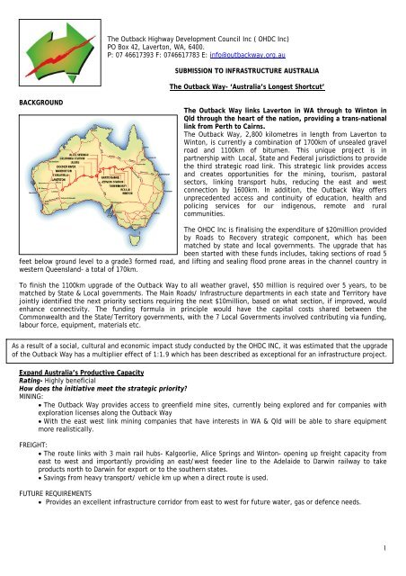
<strong>The</strong> <strong>Outback</strong> <strong>Way</strong>- ‘Australia’s Longest Shortcut’<br />
BACKGROUND<br />
<strong>The</strong> <strong>Outback</strong> <strong>Way</strong> links Laverton in WA through to Winton in<br />
Qld through the heart of the nation, providing a trans-national<br />
link from Perth to Cairns.<br />
<strong>The</strong> <strong>Outback</strong> <strong>Way</strong>, 2,800 kilometres in length from Laverton to<br />
Winton, is currently a combination of 1700km of unsealed gravel<br />
road and 1100km of bitumen. This unique project is in<br />
partnership with Local, State and Federal jurisdictions to provide<br />
the third strategic road link. This strategic link provides access<br />
and creates opportunities for the mining, tourism, pastoral<br />
sectors, linking transport hubs, reducing the east and west<br />
connection by 1600km. In addition, the <strong>Outback</strong> <strong>Way</strong> offers<br />
unprecedented access and continuity of education, health and<br />
policing services for our indigenous, remote and rural<br />
communities.<br />
<strong>The</strong> OHDC Inc is finalising the expenditure of $20million provided<br />
by Roads to Recovery strategic component, which has been<br />
matched by state and local governments. <strong>The</strong> upgrade that has<br />
been started with these funds includes, taking sections of road 5<br />
feet below ground level to a grade3 formed road, and lifting and sealing flood prone areas in the channel country in<br />
western Queensland- a total of 170km.<br />
To finish the 1100km upgrade of the <strong>Outback</strong> <strong>Way</strong> to all weather gravel, $50 million is required over 5 years, to be<br />
matched by State & Local governments. <strong>The</strong> Main Roads/ Infrastructure departments in each state and Territory have<br />
jointly identified the next priority sections requiring the next $10million, based on what section, if improved, would<br />
enhance connectivity. <strong>The</strong> funding formula in principle would have the capital costs shared between the<br />
Commonwealth and the State/Territory governments, with the 7 Local Governments involved contributing via funding,<br />
labour force, equipment, materials etc.<br />
As a result of a social, cultural and economic impact study conducted by the OHDC INC, it was estimated that the upgrade<br />
of the <strong>Outback</strong> <strong>Way</strong> has a multiplier effect of 1:1.9 which has been described as exceptional for an infrastructure project.<br />
Expand Australia’s Productive Capacity<br />
Rating- Highly beneficial<br />
How does the initiative meet the strategic priority?<br />
MINING:<br />
• <strong>The</strong> <strong>Outback</strong> <strong>Way</strong> provides access to greenfield mine sites, currently being explored and for companies with<br />
exploration licenses along the <strong>Outback</strong> <strong>Way</strong><br />
• With the east west link mining companies that have interests in WA & Qld will be able to share equipment<br />
more realistically.<br />
FREIGHT:<br />
• <strong>The</strong> route links with 3 main rail hubs- Kalgoorlie, Alice Springs and Winton- opening up freight capacity from<br />
east to west and importantly providing an east/west feeder line to the Adelaide to Darwin railway to take<br />
products north to Darwin for export or to the southern states.<br />
• Savings from heavy transport/ vehicle km up when a direct route is used.<br />
FUTURE REQUIREMENTS<br />
• Provides an excellent infrastructure corridor from east to west for future water, gas or defence needs.<br />
1
Provide Data and evidence of how the initiative meets the strategic priority<br />
• A new major garnet mine in the Harts Range area is being developed and is forecast to have a life output of<br />
approximately $3 billion.<br />
• BHP metals exploration & Newmont are actively exploring major nickel deposits near Warburton, this would<br />
involve movement of approximately 500,000 to 700,000 tonnes of ore per annum. on the <strong>Outback</strong> <strong>Way</strong>.<br />
• Other exploratory prospects along unsealed sections of the <strong>Way</strong> include base metals in the West Musgrave &<br />
Petermann Ranges area, base metals on Jervois Station( NT) and near Boulia in Queensland.<br />
<strong>TO</strong>URISM –<br />
• Permits issued between 1st Feb -28th Aug 2005 totalled 288<br />
Permits issued between 1st Feb -28th Aug 2008 totalled 627.<br />
• Camping & Motor-home Club of Australia forecast that Grey nomads will double in the next 5years and spend<br />
10 yrs travelling doing a lap of Australia every 2 yrs looking for a new route.<br />
• Desert Adventurer Bus travels from Cairns to Alice along the <strong>Outback</strong> <strong>Way</strong> 3 times/wk, and wants to expand<br />
the route to WA when the road is upgraded.<br />
FREIGHT-<br />
• <strong>The</strong> recent update of economic modelling on the Hann Highway in Qld indicated the savings for a direct route<br />
for heavy vehicles could be up as much as 40- 50%. (Cummings Economics)<br />
Outline how the initiative is dependant on policy, regulatory, demand pricing, efficiency and or capital<br />
investment initiatives.<br />
• Roads to Recovery – Strategic Component policy- which went straight to local councils and NT Government for<br />
work on their roads.<br />
• <strong>The</strong> <strong>Outback</strong> Highway Development Council Inc (OHDC Inc) has had the <strong>Outback</strong> <strong>Way</strong> assessed for Public Private<br />
Partnership value by Macquarie Bank which deemed it to be unsuitable.<br />
• Once the <strong>Outback</strong> <strong>Way</strong> is developed the ongoing maintenance and further capital works will need to be<br />
committed to by the appropriate tiers of government.<br />
Increase Australia’s productivity<br />
Rating- Highly beneficial<br />
How does the initiative meet the strategic priority?<br />
• Reduces the time between east and west by 1600km- 2 days travel for freight.<br />
• Alternative freight and product distribution routes throughout Australia.<br />
• Enables better utilisation of existing rail and road infrastructure by creating inter-modal transport hubs<br />
• Offers an alternative- taking produce up the centre for export, reducing congestion and blockages on<br />
eastern and western ports.<br />
• Triple road trains can use the route, increasing volume of freight/ trip from outside Perth to outside<br />
Townsville.<br />
• <strong>The</strong>re is an expectation the growth (especially of economies like China), will see strong demand for<br />
Australian mineral products continue. With some commodity prices coming down, achieving<br />
efficiencies in costs will be a higher priority.<br />
Provide Data and evidence of how the initiative meets the strategic priority<br />
<strong>The</strong> upgrading of the <strong>Outback</strong> <strong>Way</strong> has major travel distance implications :-<br />
• Reducing 1100 km of travel between Alice Springs and Perth and 300 – 500 km between Alice Springs<br />
and the Queensland coastal regions.<br />
2
• Reducing 1000 km between the Perth/Kalgoorlie area and the regions of northern and central<br />
Queensland.<br />
• Providing an alternative route of equal distance between Perth and Darwin.<br />
• Triple Road trains can move from 50km north of Perth through to the edge of Townsville in Qld.<br />
• <strong>The</strong> <strong>Outback</strong> <strong>Way</strong> has massive advantages making Alice Springs closer to Perth.<br />
• It results in Cairns and Townsville being even closer to Alice Springs than Perth and not that much further than<br />
Darwin and Adelaide.<br />
• It also makes Alice Springs closer to Rockhampton and Brisbane.<br />
• <strong>The</strong> distance to Sydney via the <strong>Outback</strong> <strong>Way</strong> will be only marginally more than via the southern route.<br />
ALTERNATIVE ROUTES<br />
Perth - Darwin Western Route 4043 km<br />
<strong>Outback</strong> Highway<br />
4029 km<br />
Brisbane - Perth Southern Route 4334 km<br />
<strong>Outback</strong> Highway<br />
5000 km<br />
<strong>The</strong> <strong>Outback</strong> <strong>Way</strong> will provide a route Perth to Darwin of almost identical distance to that via the Kimberley.<br />
<strong>The</strong> <strong>Outback</strong> <strong>Way</strong> route will provide an alternative route between Perth and Brisbane but about 15% longer in distance.<br />
MINING: Providing a preferred route for mining sector equipment movements<br />
• For heavy haulage of earth moving equipment- the <strong>Outback</strong> <strong>Way</strong> saves $15,000/ mining movement.<br />
• Approximately 70% of the $26 billion / year of mining activity takes place in Western Australia, Queensland and<br />
the Northern Territory.<br />
• 45% of mining companies that are active in Kalgoorlie are also active around around North West of Alice Springs<br />
and the Mt Isa region in Queensland- making equipment sharing valuable for productivity.<br />
• <strong>The</strong> <strong>Outback</strong> <strong>Way</strong> reduced the distance by 1000km between Kalgoorlie and Mt Isa saving considerable costs.<br />
All data from-OHDC Inc Social, Cultural Economic Impact Study<br />
3
Outline how the initiative is dependant on policy, regulatory, demand pricing, efficiency and or capital<br />
investment initiatives.<br />
• <strong>The</strong> <strong>Outback</strong> <strong>Way</strong> must be able to take triple road trains- this will be invaluable for freight operators and the<br />
only trans-national route of its kind in Australia.<br />
• Major long distance road transport benefits of the route include benefit from being able to use large freight<br />
efficient vehicles.<br />
CAPITAL INVESTMENT INITIATIVES- <strong>The</strong> <strong>Outback</strong> Highway’s viability is not heavily dependent on particular capital<br />
investment initiatives along its route, eg. specific mines. However, new mining initiatives currently being<br />
canvassed in the Alice Springs area would enhance the benefits of road linkages between that area and major<br />
mining service centres like Kalgoorlie and Mt Isa.<br />
Diversify Australia’s economic capabilities<br />
Rating- Highly beneficial<br />
How does the initiative meet the strategic priority?<br />
CATTLE INDUSTRY:<br />
Enables the cattle industry better access to their geographical diversification- many Central Australian Properties have<br />
properties in western Qld, for risk and drought management purposes. <strong>The</strong> <strong>Outback</strong> <strong>Way</strong> is critical infrastructure to<br />
increase efficiency in these operations.<br />
Cattle marketing in Central Australia will be diversified to include WA buyers, being able to transport cattle west.<br />
Green Brothers in WA have expressed interest in buying cattle in Alice Springs, resting them in Laverton/Kalgoorlie to<br />
take them onto their operations in WA.<br />
NEW INDUSTRIES- <strong>The</strong> upgrade of the <strong>Outback</strong> <strong>Way</strong> will also enhance logistics and support ‘in time’ chain management<br />
for the Horticulture industry and Camel industries.<br />
With the development of the <strong>Outback</strong> <strong>Way</strong> new processing industries may start up in Alice Springs, in western Qld, or<br />
in Eastern WA, to feed product to the south or north of Australia.<br />
MINING: new minerals and activity. With increased technology and access provided by the <strong>Outback</strong> <strong>Way</strong>, mining<br />
developments throughout this region of Australia have enormous growth potential.<br />
<strong>TO</strong>URISM – a new adventure route for Australian & International tourists to experience- the <strong>Outback</strong> <strong>Way</strong> is truly unique<br />
as ‘Australia’s longest shortcut’ providing a new product for the market place.<br />
<strong>The</strong> <strong>Outback</strong> <strong>Way</strong> opens up central Australia and offers new ways to see Australia- someone can land in Cairns and hire<br />
a 4WD and drive to Perth or Alice Springs then fly out to Sydney. <strong>The</strong> travel routes are numerous now people can go<br />
east to west across the centre- by car, train or air to complete their trip in inland Australia.<br />
<strong>The</strong> <strong>Outback</strong> <strong>Way</strong> is also the world’s longest geo-cache trail which is a new adventure tourism activity, with personal<br />
satellite navigation systems people find the 34 cache’s which are hidden along the <strong>Outback</strong> <strong>Way</strong>. <strong>The</strong> interest in the<br />
<strong>Outback</strong> <strong>Way</strong> is increasing as we have seen a tripling of road usage in 3 years. <strong>The</strong> growth of the people caravanning<br />
and ‘doing Australia’ is expected to double in 5yrs and although fuel prices are higher, people are staying longer in<br />
each place helping the economies of rural and remote communities.<br />
INDIGENOUS OPPORTUNITIES- the <strong>Outback</strong> way will also support the 13 indigenous communities along the route,<br />
encouraging the development of indigenous arts & crafts, bush foods, tourism businesses.<br />
Provide Data and evidence of how the initiative meets the strategic priority<br />
CATTLE INDUSTRY:<br />
• Due to the volume of livestock it can cost one producer up to an extra $40,000 to go the long way through Mt<br />
Isa- 1000 head were sent via Mt Isa costing an additional $40/head.<br />
• From Boulia to Winton when there was 70km of unsealed road- Cattle going to sale yards lost 10% weight, since<br />
the road has been sealed they lose only 4% weight. <strong>The</strong> improvement to the <strong>Outback</strong> <strong>Way</strong> equates to<br />
approximately an extra $150/head.<br />
• Northern Territory Cattleman’s Association figures on the value and marketing of Cattle in Central Australia.<br />
4
MINING:<br />
• A new major garnet mine in the Harts Range area is being developed and is forecast to have a life output of<br />
approximately $3 billion.<br />
• BHP Metal & Newmont are actively exploring major nickel deposits near and east of Warburton, this would<br />
involve movement of approximately 500,000 to 700,000 tonnes of ore per annum. on the <strong>Outback</strong> <strong>Way</strong>.<br />
• Other exploratory prospects along unsealed sections of the <strong>Way</strong> include base metals in the West Musgrave &<br />
Petermann Ranges area and base metals on Jervois Station( NT) and near Boulia in Queensland.<br />
<strong>TO</strong>URISM:<br />
• Ngaanyatjarra Land Council Permits issued for travel<br />
in the aboriginal lands in the between 1st Feb -28th<br />
Aug 2005 totalled 288<br />
Ngaanyatjarra Land Council Permits issued between<br />
1st Feb -28th Aug 2008 totalled 627.<br />
Indicating a 3 fold increase in 3 years.<br />
• <strong>The</strong> tourism trends include adventure routes, eco<br />
tourism, seeking educational experiences, fly drive<br />
packages.<br />
• Camping & Motor-home Club of Australia forecast that<br />
Grey nomads will double in the next 5years and spend<br />
10 yrs travelling. <strong>The</strong>y will complete a lap of Australia<br />
every 2 yrs and then look for a new route.<br />
• At any one time- there are 1 million people geocacheing<br />
in the world.<br />
• <strong>The</strong>re is enormous scope for new tourism bus tours, tag along tours along an upgraded <strong>Outback</strong> <strong>Way</strong>. Bus<br />
companies from Qld, NT & WA have all expressed interest in developing tours along the <strong>Outback</strong> way.<br />
• <strong>The</strong> international tourism routes- indicate the preferred routes visitors enjoy when they come to Australia-the<br />
<strong>Outback</strong> <strong>Way</strong> provides the linkages to deliver the required experience.<br />
Aboriginal communities along the <strong>Outback</strong> <strong>Way</strong> are generally the most knowledgeable of the surrounding landscape<br />
and are best placed to identify sites to locate small safari camps that provide travellers an alternative to motel rooms<br />
/ donga’s / bushcamping / campgrounds. Ideally the potential locations would be in proximity to natural features<br />
(e.g. breakaway, gnamma holes, caves, soaks, ridges, woodlands, dense scrub-bush, etc) that offer potential to<br />
supplement the accommodation experience with tours, walk trails, flora / fauna spotting or cultural talks. <strong>The</strong>re may<br />
be scope to access grant funding to design and pre-fabricate safari tents within a community before relocating to the<br />
selected sites. (OHDC Inc- Integrated Tourism Plan)<br />
HORTICULTURE: Central Australia<br />
• Horticultural production in the Alice Springs region, for example table grapes and citrus fruits, is projected to<br />
grow from approximately $20 million to $80 million over the next decade. Although most produce is projected<br />
to move south, an upgraded eastern arm of the <strong>Outback</strong> <strong>Way</strong> could, in combination with regular freight<br />
movements, open up additional markets in the eastern states of Australia.<br />
CAMEL INDUSTRY:<br />
• With an estimated 50,000 feral camels in the Central Australia / Western Desert area requiring culling at a cost<br />
of over $40+ per head to keep numbers under control, it is not surprising that a live camel exporting industry is<br />
developing in this area. It is forecast that through the development of this industry, a turnover of 50,000 head<br />
per annum over the next 10-15 years could be expected, through which the western arm of the <strong>Outback</strong> <strong>Way</strong><br />
would play a major role.<br />
Outline how the initiative is dependant on policy, regulatory, demand pricing, efficiency and or capital<br />
investment initiatives.<br />
• Tourists and travellers must seek permits from the Central Land Council and Ngaanyatjarra Land Council to<br />
travel through indigenous land west of the Kata Tjuta, this takes ½ hr and is free. <strong>The</strong> process could be sent o<br />
be problematic and restrictive, however at this stage it is useful to collect traveller numbers along these<br />
roads.<br />
• <strong>The</strong> <strong>Outback</strong> <strong>Way</strong> goes through a national park however we have a working relationship with Parks Australia.<br />
• <strong>The</strong> drivers for business investment will be driven by demand of travellers and freight movements.<br />
Build on Australia’s Competitive advantage<br />
Rating- Moderately beneficial<br />
How does the initiative meet the strategic priority?<br />
<strong>The</strong> upgrading of the <strong>Outback</strong> <strong>Way</strong> will reduce operating costs of transport operations servicing the communities along<br />
the unsealed sections of the <strong>Way</strong>, including the provision of support fuel for aviation operations at centres like<br />
Warburton that act as emergency landing alternatives and refuelling points in this vast area.<br />
5
• However, of most importance, the <strong>Outback</strong> <strong>Way</strong> reduces 1600km for movement of transports between Perth,<br />
Alice Springs and northern and central Queensland. It is expected that almost all transport movements<br />
between these areas would use an upgraded <strong>Outback</strong> <strong>Way</strong>. While the road distance between Perth and<br />
Brisbane is 15% longer than via southern routes, transport operators on the southern route are confined to<br />
using “doubles”. With “triples” being able to be used on the <strong>Outback</strong> <strong>Way</strong>, it is expected that a substantial<br />
part (but not all) of road traffic between WA and SE Qld would also utilise the <strong>Outback</strong> <strong>Way</strong>.<br />
• In addition to this the links to Ports in WA- Fremantle, Esperance, Geraldton, Carnarvon, Port Augusta,<br />
Gladstone, Mackay, Cairns, the Port of Darwin and Townsville<br />
• <strong>The</strong> <strong>Outback</strong> way improves the logistics and chain management solutions or commodities and bulk freight.<br />
• Importantly, surveying has also indicated that the <strong>Outback</strong> <strong>Way</strong> upgrading could complement the operations<br />
and profitability of the Alice Springs Darwin railway by providing improved feeder links from east and west into<br />
an Alice Springs inter-modal transfer station for north or south rail freight movement. <strong>The</strong>re would also be<br />
opportunities for transport operators in Alice Springs to develop new east – west transport opportunities to<br />
replace north – south transport operations lost as a result of the railway’s development.<br />
Provide Data and evidence of how the initiative meets the strategic priority<br />
It is expected that the <strong>Outback</strong> <strong>Way</strong> would become a major road freight link between the South West of WA and Qld<br />
for the estimated 300,000 tonnes of road freight per year travelling between these two areas. Projected interstate<br />
freight vehicle movements over the <strong>Way</strong> after upgrading are expected to be about 7 per day or 3.5 each way(2003)<br />
Travel Times<br />
Based on various discussions, we have estimated travel speeds on the Eastern and Western Arms of the Highway will improve as a result of<br />
the upgrading as follows :-<br />
Travel Speed<br />
Travel Time Unsealed Sections<br />
Current Upgraded Current Upgraded Time Saving<br />
hrs hrs hrs<br />
Light Vehicles Western Arm 80 100 12.75 10.20 2.55<br />
Eastern Arm 80 100 7.95 6.36 1.59<br />
Transports Western Arm 50 70 20.40 14.57 5.83<br />
Eastern Arm 50 70 12.72 9.09 3.63<br />
Coaches Western Arm 60 80 17.00 12.75 4.25<br />
Eastern Arm 60 80 10.06 7.95 2.11<br />
Linking to existing infrastructure throughout Australia-<br />
Develop our cities and regions<br />
Rating- Highly beneficial<br />
How does the initiative meet the strategic priority?<br />
<strong>TO</strong>URISM- <strong>The</strong> increasing tourist activity is having significant flow on effect to local communities along the route, with<br />
more cash being injected in to the local economies. New tourism infrastructure is being developed, new packages and<br />
tourism trails are being marketed increasing tourism interest along the <strong>Outback</strong> <strong>Way</strong>.<br />
With a more reliable route through central Australia international tourists would be attracted to experience the<br />
<strong>Outback</strong> <strong>Way</strong> -contributing to the economies of the smaller communities, rather than flying in and out. With 631,000<br />
overnight visitors in Central Australia annually with an average spend of $185/day, 10% of these travellers would<br />
provide enormous economic boost to the region.<br />
Sustainability for a route such as the <strong>Outback</strong> <strong>Way</strong> can include environmental, social and economic considerations.<br />
Social sustainability along the <strong>Outback</strong> <strong>Way</strong> is expected to be enhanced as traffic and visitation increase. Social<br />
sustainability would improve with an increase in employment opportunities, enhanced viability for local enterprises,<br />
increased opportunity for enterprise development, increased opportunity for community involvement in cultural<br />
activities (e.g. art, craft, guided walks – tours) and enhanced scope to improve community income and investment.<br />
BUSINESSES- as the <strong>Outback</strong> <strong>Way</strong> is upgraded there will be growth in roadhouses along the route, quick vehicle repair<br />
centres and potential indigenous tourism activity.<br />
6
Provide Data and evidence of how the initiative meets the strategic priority<br />
<strong>TO</strong>URISM<br />
• Winton: 2007 19,500 visitors @ $95/day returning $1.8million<br />
2008 Jan – Aug- 13,100 visitors @$95/day returning $1.25million<br />
• WA Golden <strong>Outback</strong> Region- 2007-<br />
789,900 visitors o/nite @$107/day<br />
$85million<br />
• <strong>The</strong> OHDC INC Integrated Tourism<br />
Study indicates that;<br />
• Community-run roadhouses, especially<br />
those in WA, could improve the range<br />
of services available by offering for<br />
example, roadside assistance, car/tyre<br />
repairs, vehicle recovery service (i.e.<br />
mobi-tow like facilities), short guided<br />
tours (tucker, culture, medicine,<br />
dreamtime), evening meals to groups,<br />
art workshops, etc. In most cases this<br />
will require the development of<br />
indigenous enterprises and grant<br />
funding could be accessible.<br />
• Aboriginal communities could provide<br />
access to selected tracks to known sites/attractions/points of interest. <strong>The</strong>se could be sign-posted as strictly 4WD<br />
only – meaning self-sufficiency is required. This would create additional scope for ‘adventure’ travellers (e.g.<br />
4WD’ers) to discover the outback and could lead to enterprise opportunities for local communities offering guided<br />
tours, user pays-camping, the sale of fuel-food, meals/accommodation, cultural talks at designated sites, bush<br />
tucker tours / tasting, etc.<br />
(OHDC Inc Integrated Tourism Plan)<br />
Reduce greenhouse emissions<br />
Rating- Moderately beneficial<br />
How does the initiative meet the strategic priority?<br />
• By the reduction of distance the <strong>Outback</strong> <strong>Way</strong> provides, and by bringing the east and west of Australia closer.<br />
• Also enabling better use of existing infrastructure by being the feeder to railway and ports- this will reduce<br />
emissions and transport will be on the road for shorter periods of time.<br />
• <strong>The</strong> <strong>Outback</strong> <strong>Way</strong> can take triple road trains so can take 1/3 more product/ trip reducing fuel consumption<br />
and costs for companies and as a result reducing emissions.<br />
Provide Data and evidence of how the initiative meets the strategic priority<br />
• <strong>The</strong> <strong>Outback</strong> <strong>Way</strong> – tourism project has a carbon offset program for travellers of the <strong>Outback</strong> <strong>Way</strong>. <strong>Outback</strong><br />
<strong>Way</strong> travellers pay $40 to offset their carbon emissions generated from travelling the <strong>Outback</strong> <strong>Way</strong>. <strong>The</strong> OHDC<br />
who in turn commissions a tree-grower (e.g. Landcare, Men of <strong>The</strong> Trees, Carbon Neutral, etc) who would<br />
receive $12-$18 to plant 4-8 trees. This could be extended to freight and transport.<br />
• Previous maps have illustrated the reduced travel times the <strong>Outback</strong> <strong>Way</strong> delivers.<br />
Outline how the initiative is dependant on policy, regulatory, demand pricing, efficiency and or capital<br />
investment initiatives.<br />
• <strong>The</strong> <strong>Outback</strong> <strong>Way</strong> can take triple road trains, unlike the Nullarbor Route that is limited to B Doubles.<br />
• <strong>The</strong> 7 Shires have collectively agreed on a 9m wide road surface for any works being done along the <strong>Outback</strong><br />
<strong>Way</strong>, ensuring safety for passing trucks and vehicles alike.<br />
Improve social equity and quality of life in our cities and regions<br />
Rating- Highly beneficial<br />
How does the initiative meet the strategic priority?<br />
CATTLE: Provides critical infrastructure to access markets for drought affected areas, particularly Central Australia<br />
and Western Queensland.<br />
DEFENCE: A large part of the nation’s defence capabilities are now located in Australia’s north and west, areas of<br />
greater vulnerability and closer to likely world and regional trouble spots. <strong>The</strong> <strong>Outback</strong> <strong>Way</strong> will play a role in<br />
providing an important “interior line of communication and transportation” route between defence capabilities in<br />
Australia’s north east and west and an alternative interior link to Darwin. It will also link some of Australia’s important<br />
7
surveillance facilities. <strong>The</strong> <strong>Outback</strong> <strong>Way</strong> needs to be considered as part of the recently announced Defence audit and<br />
assessment. <strong>The</strong> <strong>Outback</strong> <strong>Way</strong> links up the Jindalee Over the Horizon Radar Project-with radar facilities in Laverton,<br />
Harts Range and South of Longreach.<br />
REGIONAL DEVELOPMENT:<br />
In regional development terms the road supports the entire region from Laverton through to Winton. Tourism<br />
opportunities, water resource development, housing, infrastructure supporting aircraft movements in and out of<br />
communities, health services, education, fuel supplies, infrastructure planning – the <strong>Outback</strong> <strong>Way</strong> assists these<br />
essential services to be organized in a disciplined way helping the integration of institutions and communities to<br />
successfully knit together.<br />
Increased tourism and road traffic will have a significant impact on economic opportunities in the existing small<br />
communities along the unsealed sections of the <strong>Way</strong>. In national terms, the impacts involved in business development<br />
and employment are relatively small.<br />
SERVICES & QUALITY OF LIFE-<br />
Remote and isolated communities rely on the <strong>Outback</strong> <strong>Way</strong> for food, groceries, fuel and government services such as<br />
education, health and policing. With an improved road people in these communities would enjoy cheaper living costs<br />
and an improved diet with fresh vegetables, fruit , bread and milk- currently these can only purchased in cans or<br />
frozen respectively.<br />
Thirteen communities rely directly on the Western Australian section of road for their survival. But there are many<br />
more communities in the adjoining desert regions where circumstances are such that life is very fragile. Other more<br />
obvious beneficiaries of improvements to the dirt road include the mining industry, transiting travellers, the transport<br />
and commercial industry that service the inland region of the continent and, government people from the public<br />
sector, including the police.<br />
<strong>The</strong> continuity of health and educational services is limited due to access issues as the road may be in poor condition<br />
due to heavy transport or too wet. Staff for these agencies don’t seem to stay in these communities resulting in<br />
inconsistent service delivery -As long as people know they can leave a place when they want to, they will stay.<br />
Provide Data and evidence of how the initiative meets the strategic priority<br />
CATTLE: 22 triple road trains/ day over 4 months out of Boulia due to drought<br />
Over 500 triple road trains using single lane bitumen July 07 to June 08(149700 head 4737 decks away 1500 decks<br />
returning, 6237 decks, 6 decks per truck =1040 trucks)<br />
DEFENCE:<br />
<strong>The</strong> Social Cultural & Economic Impact study survey found that the pastoralists<br />
interviewed indicated the following expectations for social and ‘quality of life’<br />
benefits following the proposed upgrade of the <strong>Outback</strong> Highway:<br />
• 86% of pastoralists interviewed saw road safety as the impact with the<br />
highest priority.<br />
• None of the pastoralists interviewed indicated that the expected road safety<br />
impacts were not a priority.<br />
• 80% indicated that recreational and general social benefits were expected.<br />
• 66% indicated that schooling and educational services benefits were<br />
expected.<br />
• 60% indicated that health and medical service benefits were expected<br />
although 47% of pastoralists indicated that these potential benefits<br />
were not a priority, for them.<br />
• 53% indicated that general community and other government service benefits were expected although 57% of<br />
pastoralists indicated that these potential impacts were not a priority, for them.<br />
• 47% indicated that policing and security service benefits were expected although 54% of pastoralists indicated that<br />
these potential impacts were not a priority, for them.<br />
Outline how the initiative is dependant on policy, regulatory, demand pricing, efficiency and or capital<br />
investment initiatives.<br />
• <strong>The</strong> <strong>Outback</strong> Highway route avoids the safety problems of heavy transports having to pass through cities<br />
and highly populated areas.<br />
Linkages<br />
Rating- Highly beneficial<br />
How does the initiative meet the strategic priority?<br />
Tourism routes – the <strong>Outback</strong> <strong>Way</strong> connects the void in Central Australia- connecting travellers with the tourism routes<br />
of WA, SA, NT and Qld directly. <strong>The</strong> <strong>Outback</strong> <strong>Way</strong> links the Stockman’s Hall of Fame ( Longreach), the Transporters<br />
Hall of Fame ( Alice Springs) and the Miners Hall of Fame( Kalgoorlie)<br />
Road network/ rail hubs/ Ports: With the <strong>Outback</strong> <strong>Way</strong>- product can go from east to west, west to east, west to the<br />
centre, east to the centre and up to the Port of Darwin by rail.<br />
Organisation the OHDC Inc is linked with- OHDC Inc members include<br />
8
• Local Governments who make up the OHDC Inc across the entire route from Laverton WA- Winton Qld-<br />
Laverton Shire, Ngaanyatjarraku Shire, MacDonnell Shire, Alice Springs Town Council, Central Desert Shire,<br />
Boulia Shire, Winton Shire<br />
• Regional Development Agency (ACC’s ) Goldfields Esperance, NT & Central Qld.<br />
• Goldfields Esperance Economic Development Corporation<br />
• Representatives from Main roads WA, Main Road Qld, and NT Infrastructure & Planning<br />
• Central Lands Council, Ngaanyatjarra Land Council<br />
Provide Data and evidence of how the initiative meets the strategic priority- see maps throughout submission<br />
Support from –<br />
• Australian Local Government Association, Leonora<br />
Shire<br />
• Minerals Council of Australia, Northern Territory<br />
Cattleman’s Association<br />
• Remote Area Planning and Development Board –<br />
Longreach, Winton, Isisford, Diamantina, Boulia,<br />
Barcoo, Barcaldine, Ilfracombe, Blackall.<br />
• Transport Hall of Fame- Alice Springs, Desert Sands<br />
Cartage<br />
• Hampton’s Transport Services, Penns Cartage<br />
Kalgoorlie, Australian Trucking Association,<br />
• Australian Agricultural Co, Northern Australia<br />
Pastoral Company<br />
•<br />
•<br />
Linkages to other roads, rail and ports<br />
Moneterised Benefits & Costs- outline of capital expenditure attached pages 11-15<br />
C) SUMMARY OF BENEFITS<br />
<strong>The</strong> following summarises the Net Present Values identified. Those given in brackets are the comparable “on-road” costs where<br />
“diverted/other” figures are used.<br />
Western Arm $ Million (cf On-Road Saving)<br />
Locals<br />
$7.213 m<br />
Business<br />
$8.404 m<br />
Tourists $17.204 m ($11.766 m)<br />
Coaches $34.278 m ($18.167 m)<br />
Cattle<br />
$0.910 m<br />
Camels<br />
$8.993 m<br />
Local Freight<br />
$18.347 m<br />
Interstate Freight * $34.510 m ($40.490 m)<br />
Heavy Equipment *<br />
$6.867 m<br />
Accident Injury Cost Savings + $3.700 m<br />
Total<br />
$140.426 m<br />
Eastern Arm<br />
$ Million<br />
Locals<br />
$1.103 m<br />
Business<br />
$1.462 m<br />
Tourists $18.031 m ($9.793 m)<br />
Coaches $5.925 m ($11.184 m)<br />
Cattle $4.709 m ($2.930 m)<br />
Local Freight<br />
$2.049 m<br />
Interstate Freight * $22.152 m ($20.248 m)<br />
Heavy Equipment *<br />
$4.209 m<br />
Accident Injury Cost Savings + $1.796 m<br />
Total<br />
$61.436 m<br />
Overall Total<br />
$201.862 m<br />
* NOTE :<strong>The</strong>se are benefits that only accrue if both arms of the <strong>Outback</strong> Highway are upgraded.<br />
+ NOTE : For existing traffic only.<br />
<strong>The</strong> following table compares these with the initial capital cost and maintenance costs (rendered into “resource price” terms).<br />
Western Arm<br />
$m<br />
Eastern Arm<br />
$m<br />
Total<br />
$m<br />
Benefits $140.426 m $61.436 m $201.862 m<br />
Less Maintenance Costs $24.405 m $16.613 m $41.018 m<br />
Net Benefits $116.021 m $44.823 m $160.844 m<br />
Capital Costs $42.332 m $41.315 m $83.647 m<br />
Benefit Cost Ratio 2.741 1.085 1.923<br />
9
TABLE – ESTIMATED MAINTENANCE COSTS CURRENTLY UNSEALED SECTIONS OF<br />
THE OUTBACK HIGHWAY – CURRENT & AT ALL-WEATHER GRAVEL STANDARD<br />
Km<br />
Current At All-weather Gravel Difference<br />
$ per Km Total $ per Km Total Total<br />
Laverton to WA/NT Border 829 $603 $500,000 $3,000 $2,487,000 $1,987,000<br />
WA/NT Border to Kata Tjuta 191 $1,460 $278,860 $2,500 $477,500 $198,640<br />
Plenty Hwy to NT/QLD Border 401 $,900 $367,200 $2,500 $1,020,000 $652,800<br />
NT/QLD Border to Boulia 230 $,870 $200,000 $4,500 $1,035,000 $835,000<br />
<strong>TO</strong>TAL $3,673,440<br />
Allowing 10% reduction to reduce to a “resource price” basis, Net Present Value of the above at a 7% discount<br />
rate is Western Arm $24.405m, Eastern Arm $16.613m, giving a total of $41.018 million.<br />
Source of Capital - Table 1. Source of Capital- Total capital targeted to be raised from all sources is $ million (Table<br />
1)<br />
Amount ($m)<br />
State / Territory Governments<br />
Qld State Government & Shires $3,116,000<br />
WA State Government & Shires $3,402,000<br />
Northern Territory Government & Shires $3,482,000<br />
Sub Total $10,000,000<br />
Federal Government $10,000,000<br />
Total $20,000,000<br />
Accident Costs<br />
It is concluded in this section that accident injury savings as a result of the upgrading on current traffic levels<br />
would be about $247,000 pa. on the Western Arm and $120,000 pa. on the Eastern Arm, giving a total of about<br />
$367,000 pa. Allowing for some natural growth in the existing traffic would give an approximate Net Present<br />
Value of the stream of benefits from accident injury cost savings on the Western Arm of about $3,700m and on<br />
the Eastern Arm of about $1.796m, ie. a total of about $5.496m.<br />
Non- Moneterised Benefits & Costs<br />
Road construction and maintenance is commonly viewed as an employment-generator. In the general<br />
community employment is viewed as an economic issue and as function of individual development that leads to<br />
personal empowerment and community stability. All of these issues and others – traditional values, culture,<br />
building capacity, and finding ways to overcome boredom - are also important to Aboriginal communities.<br />
(OHDC Inc - social, cultural & economic Impact Study)<br />
Further non monetised benefits are outlined in the social equity and quality of life strategic goal.<br />
Conclusion-<br />
<strong>The</strong> upgrade of the <strong>Outback</strong> <strong>Way</strong> enables the Commonwealth Government to achieve its clear and committed policy of<br />
working directly and through the States and Local Government in providing funding for; improved indigenous health,<br />
education and community welfare, improved major infrastructure for Australia, and the development of Australia’s<br />
unique tourism industry. <strong>The</strong> <strong>Outback</strong> <strong>Way</strong> assists the Commonwealth government to directly deliver on these policies.<br />
Our supporting evidence is sourced from the OHDC Inc Social Cultural & Economic Impact Study and Integrated Tourism<br />
Plan.<br />
It is in this context, this submission for $50 million through Infrastructure Australia is being sought to support the<br />
completion of this important strategic road link between WA and QLD.<br />
10
Capital Requirements- Priority sections of the <strong>Outback</strong> <strong>Way</strong>- Itemised by all 3 main roads departments in Qld, NT & WA<br />
Table 2. Use of Capital for <strong>Outback</strong> <strong>Way</strong><br />
OUTBACK HIGHWAY – $10 Million Combined Priority Projects 2009-10<br />
PRIORITY LIST<br />
Priority<br />
Location<br />
(Chainage-km)<br />
1 269.3 – 282.5<br />
(13.2km)<br />
Road & (Road<br />
Priority)<br />
Laverton<br />
WA<br />
Scope of Work<br />
Clear, form and construct on existing<br />
(8.9km) and new alignment (4.3km)<br />
with sheeted surface<br />
Justification<br />
Combined poor horizontal/vertical geometry with low<br />
lying formation prone to inundation in wet, particularly<br />
at bog hole locations<br />
Estimated<br />
Cost<br />
$990,000<br />
2 Donohue Hwy<br />
100.5 to 105.6<br />
3 Donohue Hwy<br />
79.4 – 84.9<br />
QLD<br />
Cottonbush Creek<br />
Floodplain<br />
QLD<br />
4* 115.9 - 128 Tjukaruru Road<br />
(Docker River<br />
Road) NT<br />
5 443.5 – 462.53<br />
(19.3km)<br />
6 Donohue Hwy<br />
97.9 – 100.5<br />
Ngaanyatjarraku<br />
WA<br />
QLD<br />
Raise formation, numerous<br />
watercourses, construct floodway,<br />
concrete margin, gravel paving –<br />
5.1km.<br />
Form, pave and bitumen surfacing of<br />
Cottonbush Creek Flood Plain<br />
Raise, Reform and gravel, improve<br />
drainage.<br />
Form up and reconstruct existing<br />
alignment with new pavement and<br />
selected geometric and drainage<br />
improvements<br />
Widen and regrade formation over<br />
rocky ground in hilly country. Paving<br />
and bitumen surfacing, upgrade<br />
drainage – 2.6km.<br />
Existing pavement worn out, bulldust sections several<br />
short sharp gullies prone to scouring in wet. Expensive<br />
section to maintain<br />
Wide flat watercourse extends 5.5km beyond main<br />
channels and is the site of extensive flood damage in wet<br />
seasons.<br />
This whole road section is 300 to 500mm below ground<br />
level in sandy dune country, with minimal drainage. <strong>The</strong><br />
drainage is complicated by high velocity water runoff<br />
from ranges and ponding in swamp areas.<br />
Narrow low formation which includes 7 sub-standard<br />
curves, 1 dangerous crest and 2 floodway locations<br />
requiring treatment<br />
Rough stoney surface, and short low radius curves,<br />
hazardous to stock transports.<br />
$306,000<br />
$990,000<br />
$1,740,000<br />
$1,322,000<br />
$440,000<br />
7 Donohue Hwy<br />
231.0 – 164.0<br />
QLD<br />
Resheet and break up pavement top<br />
with grid roller<br />
Paving of existing natural low standard loam formation,<br />
which perform poorly during prolonged dry periods and<br />
breaks down into bull dust. Safety problem for all<br />
vehicles.<br />
$570,000<br />
8<br />
21 – 33<br />
(14km)<br />
NT<br />
Tjukaruru Road<br />
(TR1)<br />
Raise, reform and gravel sand dune<br />
sections and improve drainage<br />
With current traffic loads, the low strength natural sandy<br />
material over this section through sand dunes has<br />
collapsed requiring lifting and capping with gravel.<br />
Significant ponding<br />
$1,742,000<br />
11
9 93 – 107.5<br />
(14.5km)<br />
Laverton<br />
WA<br />
Form up and reconstruct existing<br />
alignment with improved sheeted<br />
pavement<br />
Very rough section constructed of bony material with<br />
rock outcrops prone to corrugation.<br />
$1,090,000<br />
10 Donohue Hwy<br />
77.6 – 79.4 &<br />
84.9 – 87.6<br />
QLD<br />
Form, pave and bitumen surface outer<br />
Cottonbush Creek Floodplain<br />
Connect existing bitumen to bitumen provided in QLD2<br />
(1.8km) and extend for 2.7km to the west to prevent<br />
flood damage in outer Cottonbush Creek Floodplain<br />
$810,000<br />
Total Preliminary Estimated cost of 10 Priorities<br />
* This project may be completed in 2008-09- however it is a critical section, and due to clearance issues this project may roll into 2009-10, if not<br />
another section from the NT future priority improvement list will be moved to the 2009-10 works programme.<br />
$10,000,000<br />
Projected Stages- 3, 4, 5 & 6 ( consecutive budget years)<br />
Priority sections identified for the following budget years- 20010-11 until 2013-14<br />
OUTBACK WAY (GREAT CENTRAL ROAD)<br />
PRIORITY IMPROVEMENT SECTIONS IN WESTERN <strong>AUSTRALIA</strong><br />
Priority Location<br />
(SLK Section)<br />
4 352 – 384<br />
(32km)<br />
5 817.2 – 846.7<br />
(29.5km)<br />
6 147.9 – 153.4<br />
(5.5km)<br />
7 198 – 219<br />
(21km)<br />
8 500 – 508.5<br />
(8.5km)<br />
Local Authority Scope of Work Justification<br />
Laverton<br />
Ngaanyatjarraku<br />
Laverton<br />
Laverton<br />
Ngaanyatjarraku<br />
Form and construct water bound pavement<br />
on existing (24km) and new alignment<br />
(8km)<br />
Form up and construct on existing<br />
alignment with improved pavement with<br />
selected geometric and drainage<br />
improvements.<br />
Form up and reconstruct on existing<br />
alignment with water bound pavement<br />
Form and construct water bound pavement<br />
on existing alignment<br />
Form up and reconstruct existing<br />
alignment with improved sheeted surface<br />
(Includes recon of Tjirrkali Nth Turnoff)<br />
Poor horizontal geometry (realignments proposed),<br />
narrow low standard formation prone to severe<br />
corrugation<br />
Narrow, depressed formation with five substandard<br />
curves and four major creek crossings requiring<br />
improvement. Also requires intersection improved<br />
with Sandy Blight Rd.<br />
Very poor condition, low level section, of sand clay<br />
construction and prone to corrugation. Two flood<br />
sections require treatment<br />
Narrow low standard formation prone to<br />
corrugation with three separate curves requiring<br />
radius increases to improve safety<br />
Narrow low formation which remains corrugated<br />
even after grading includes very poor standard<br />
intersection which requires reconstruction<br />
Estimated Cost<br />
$2,400,000<br />
$2,065,000<br />
$415,000<br />
$1,575,000<br />
$595,000<br />
9 540 – 548 Ngaanyatjarraku Reconstruct and primerseal 7m wide on Dust suppression for Warburton Community is an<br />
$2,400,000<br />
(8.0km)<br />
existing alignment and construct improved issue. Elder Ck crossings are in poor condition and<br />
floodways at Elder Ck North and South require permanent treatment. Tie in with<br />
community road sealing operations.<br />
10 8.33 – 15.83 Laverton Reconstruct and primerseal 7m wide on Extend seal north of Laverton and link previously $2,060,000<br />
12
(7.5km)<br />
<strong>TO</strong>TAL COST<br />
existing alignment and reseal existing<br />
sealed floodways<br />
sealed floodways (530m total length). Will also<br />
provide sealed passing opportunity.<br />
$11,095,415<br />
Notes<br />
1. SLK (Straight Line Kilometre) sections are based on MRWA Alignment plans for the Great Central Road developed in 1997/98. SLKs commence at the intersection of<br />
Great Central Road and the Leonora – Laverton Rd.<br />
2. Construction costs for a 10m wide formation including appropriate off road drainage have been estimated as:<br />
Clear, form and construct with water bound pavement - $75,000 / Km<br />
Clear, form and construct sheeted gravel surface (no water)- $70,000 / Km<br />
3 Costs to undertake sealing projects at Priority Projects 9 and 10 have been estimated at $300,000/km for Warburton and $275,000/km at Laverton.<br />
OUTBACK WAY – QUEENSLAND<br />
FUTURE PRIORITY IMPROVEMENTS<br />
Priority<br />
QLD5<br />
Location<br />
(SLK Section)<br />
Donohue Hwy<br />
138.4 – 164.0<br />
Local<br />
Authority/Roa<br />
d<br />
Scope of Work<br />
Major realignment (referred to in earlier<br />
studies as Realignment B)<br />
Justification<br />
If and when the section is formed and paved it would be<br />
more economical to do it on the new alignment past<br />
Lake Wanditti. Considerable distance saved.<br />
Estimated Cost<br />
$2,100,000<br />
QLD7<br />
QLD8<br />
Donohue Hwy<br />
11.3 – 21.3<br />
Donohue Hwy<br />
229 – 239<br />
Kelley Ck to<br />
Ridges<br />
<strong>TO</strong>TAL COST<br />
Realign road from Ch 17.4 to Ch 20.1 and<br />
pave and seal Ch 11.3 to 21.3<br />
Pave and bitumen<br />
Realignment and earthworks to avoid sharp curve near<br />
crest and improve alignment through a creek bed.<br />
Paving and bitumen sealing the whole section to<br />
prevent loss of gravel and extend existing bitumen<br />
Flooding will cause damage to newly improved section.<br />
Remote location 220km from Boulia with resultant high<br />
repair costs.<br />
$1,800,000<br />
$1,800,000<br />
$5,700,000<br />
13
OUTBACK WAY – NORTHERN TERRI<strong>TO</strong>RY<br />
PRIORITY LIST – September 2007<br />
Future – NT -Priorities<br />
Priority<br />
Location<br />
(Chainage-km)<br />
Road & (Road<br />
Priority)<br />
PT1 200 - 229 Plenty<br />
Highway (PT1)<br />
Scope of Work<br />
Raise, Reform and regravel, improve<br />
drainage.<br />
Justification<br />
Estimated Cost<br />
No, shape, No drainage, very sandy road surface $2,000,000<br />
PT2 400 - 460 Plenty<br />
Highway (PT2)<br />
PT3 293.5 – 325.0 Plenty<br />
Highway (PT3)<br />
PT4 288.25 – 293.50 Plenty<br />
Highway (PT4)<br />
Widening and lift existing formation,<br />
upgrade gravel pavement and install<br />
improved drainage.<br />
Margins and stabilised floodways at Bonya<br />
Creek, lifting & widening the gravel<br />
formation, and drainage works.<br />
Concrete Margins and stabilised<br />
pavement. Forming Lifting, widening,<br />
gravel sheeting, drainage works.<br />
Section has narrow running widths and steep batters $3,500,000<br />
with formation up to 300mm below natural surface in<br />
sections and drainage problems with ponding water.<br />
This section currently has many areas, which in the wet $3,500,000<br />
causes lengthy closures due to ponding of water and<br />
bog holes, with the road surface being up 300m below<br />
natural surface level.<br />
This section currently has many areas, which in the wet $600,000<br />
causes lengthy closures due to ponding of water and<br />
bog holes, with the road surface being up 300m below<br />
natural surface level.<br />
No, shape, No drainage, very sandy road surface $2,400,000<br />
PT5 181 - 220 Plenty<br />
Highway (PT5)<br />
Raise, Reform and regravel, improve<br />
drainage.<br />
<strong>The</strong> Commonwealth Government is providing $8.0 million for upgrading the Plenty Highway as part of the $81 million Community, Beef and Mining<br />
Roads Upgrade Program of which the Australian Government will fund $52 million and the Northern Territory Government $29 million. <strong>The</strong> priorities<br />
for the Northern Territory Government – Plenty Highway will be considered in scoping the $8.0 million proposed program.”<br />
TR1<br />
33 – 55<br />
Tjukaruru<br />
Road (TR1)<br />
Raise, reform and gravel sand dune<br />
sections and improve drainage<br />
With current traffic loads, the low strength natural<br />
sandy material over this section through sand dunes has<br />
collapsed requiring lifting and capping with gravel.<br />
Significant ponding<br />
$1,258,000<br />
TR2<br />
171 – 181 Tjukaruru<br />
Road (TR2)<br />
Raise, reform and gravel and improve<br />
drainage<br />
This whole road section is 300 to 500mm below ground<br />
level in sandy dune country, with minimal drainage.<br />
$1,250,000<br />
14
TR3 181-189 Tjukaruru<br />
Road (TR3)<br />
Widening and lift existing formation,<br />
upgrade gravel pavement and install<br />
improved drainage.<br />
Section has narrow running widths and steep batters<br />
with formation up to 300mm below natural surface in<br />
sections and drainage problems with ponding.<br />
$1,000,000<br />
TR4 0 -21 Tjukaruru<br />
Road (TR4)<br />
Raising the formation, widen and gravel<br />
and associated drainage works<br />
Poor draining and ponding causes closures in the wet.<br />
Current running surface is extremely rough upgrade<br />
well below natural surface level.<br />
$2,000,000<br />
$17,508,000<br />
Total Preliminary Estimated cost of 9 Priorities<br />
* <strong>The</strong>se future priority sections have been identified for further years of funding- however priority sections need to be reviewed annually as weather and usage can alter<br />
road condition significantly.<br />
15