Introduction - Union of British Columbia Indian Chiefs
Introduction - Union of British Columbia Indian Chiefs
Introduction - Union of British Columbia Indian Chiefs

Create successful ePaper yourself
Turn your PDF publications into a flip-book with our unique Google optimized e-Paper software.
Chief<br />
Kerry’s<br />
Moose<br />
a guidebook<br />
to land use and<br />
occupancy mapping,<br />
research design<br />
and data collection<br />
➛<br />
➛<br />
➛<br />
by Terry N. Tobias<br />
A joint publication <strong>of</strong> the <strong>Union</strong> <strong>of</strong> BC <strong>Indian</strong> <strong>Chiefs</strong> and Ecotrust Canada
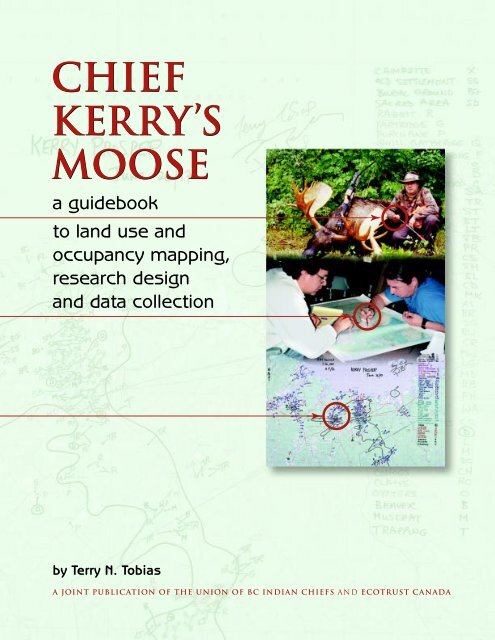
THE FRONT COVER<br />
The top photograph on the front cover shows Kerry Prosper, who was Chief <strong>of</strong> the<br />
Afton First Nation at the time, with a bull moose he killed in 1995 to feed his family.<br />
This particular hunt was believed to be the first time in generations that a Mi'kmaq<br />
hunter killed a moose using a recurved bow. For this reason, this hunt held some<br />
symbolic importance for the nation. The middle photo shows James Michael, Director<br />
<strong>of</strong> the Treaty and Aboriginal Rights Research Centre <strong>of</strong> Nova Scotia, conducting a<br />
land use and occupancy mapping session with Kerry in 1997. The bottom photo<br />
depicts one <strong>of</strong> Kerry’s map biography overlays that resulted from the interview.<br />
One <strong>of</strong> the hundreds <strong>of</strong> sites mapped is the location in the French Lakes area <strong>of</strong><br />
Cape Breton where Kerry knocked down that moose.
Chief<br />
Kerry’s<br />
Moose<br />
a guidebook to land use<br />
and occupancy mapping,<br />
research design and<br />
data collection<br />
Part one in a series <strong>of</strong> publications intended for First Nation<br />
researchers and decision makers, illustrating best practices<br />
in land use and occupancy research and mapping.
Copyright © 2000 by Terry Tobias<br />
00 01 02 03 4 3 2 1<br />
Rights reserved. This book may be reproduced or transmitted in any form by any means,<br />
electronic or mechanical, including photocopying and recording, or by any information<br />
storage or retrieval system, without permission from the publisher or author. The book<br />
can be downloaded from either the <strong>Union</strong> <strong>of</strong> BC <strong>Indian</strong> <strong>Chiefs</strong> web site (below) or the<br />
Aboriginal Mapping Network web site (http://www.nativemaps.org). No part <strong>of</strong> the<br />
book may be modified, re-packaged or resold without the written permission <strong>of</strong> the<br />
author, who can be contacted through Ecotrust Canada.<br />
The views expressed in this publication are those <strong>of</strong> the author, and are not necessarily<br />
shared by the <strong>Union</strong> <strong>of</strong> BC <strong>Indian</strong> <strong>Chiefs</strong> or Ecotrust Canada.<br />
<strong>Union</strong> <strong>of</strong> BC <strong>Indian</strong> <strong>Chiefs</strong><br />
342 Water Street, 5th Floor<br />
Vancouver, B.C., V6B 1B6, Canada<br />
Telephone (604) 684-0231<br />
Web site␣ ␣ http://www.ubcic.bc.ca<br />
Ecotrust Canada<br />
1226 Hamilton Street, Suite 202<br />
Vancouver, B.C., V6B 2S8, Canada<br />
Telephone (604) 682-4141<br />
Web site␣ ␣ http://www.ecotrustcan.org<br />
Canadian Cataloguing in Publication Data<br />
Tobias, Terry N., 1951–<br />
Chief Kerry’s moose<br />
Copublished by: Ecotrust Canada.<br />
ISBN 1-896866-04-2<br />
1. Native peoples – Land tenure – Canada – Maps.* 2. Native peoples –<br />
Land tenure – Canada – Research.* 3. Land use – Canada – Maps.<br />
4. Land use – Canada – Research. I. <strong>Union</strong> <strong>of</strong> <strong>British</strong> <strong>Columbia</strong> <strong>Indian</strong> <strong>Chiefs</strong>.<br />
II. Ecotrust Canada. III. Title.<br />
E78.C2T62 2000 333.2’089’97071 C00-910464-X<br />
Price: $14.95<br />
Additional copies <strong>of</strong> this publication may be purchased through the <strong>Union</strong> <strong>of</strong> BC<br />
<strong>Indian</strong> <strong>Chiefs</strong>.<br />
Published with assistance from the <strong>Union</strong> <strong>of</strong> BC <strong>Indian</strong> <strong>Chiefs</strong> and the Walter and<br />
Duncan Gordon Foundation.<br />
Edited by Alex Rose<br />
Design and production by Alaris Design, Victoria<br />
Figures and sketches by Dirk Van Stralen<br />
Maps by Arbex Forest Resource Consultants Ltd.<br />
Printing by Western Printers and Lithographers<br />
Printed and bound in Canada<br />
Printed on Domtar Naturals, minimum 50% recycled/30% post-consumer waste
Bazile Decoursay<br />
1928‒1993<br />
To Elder Bazile Decoursay, and all the elders<br />
whose knowledge and wisdom continue to<br />
enrich and revitalize the younger generations<br />
<strong>of</strong> both First Nation and non-native peoples.<br />
and<br />
To Dr. Peter Usher and Dr. Martin Weinstein,<br />
generous colleagues and mentors, and leaders among<br />
those who pioneered the Canadian land use and occupancy<br />
research methodologies that are now being adapted<br />
by indigenous cultures around the globe.
CONTENTS<br />
<strong>Introduction</strong> ..................................................................................................................................... xi<br />
1 Land Use and Occupancy Mapping:<br />
A Definition and A Warning .......................................................................................... 1<br />
2 The Tasks <strong>of</strong> a Mapping Project ................................................................................... 4<br />
3 Map Biographies and Composites .........................................................................12<br />
4 Doing Quality Research .....................................................................................................19<br />
5 Designing the Project:<br />
Why, Who, When, Where and What ...................................................................33<br />
6 Principles <strong>of</strong> Research Design and Implementation ........................38<br />
7 Measuring Quality ....................................................................................................................49<br />
8 Creating a Culture <strong>of</strong> Research ..................................................................................56<br />
Summary .............................................................................................................................................58<br />
Glossary .................................................................................................................................................62
Foreword<br />
Information – access to it, or access denied – has long been at the<br />
root <strong>of</strong> how communities have expressed who they are, to themselves<br />
and outsiders. The oral traditions <strong>of</strong> First Nations have been –<br />
for hundreds <strong>of</strong> years – cherished and deeply respected ways <strong>of</strong><br />
communicating complex information about culture, politics, the environment,<br />
and what we now call economics. After European contact, these oral<br />
communications were given less and less weight, and First Nations were<br />
put at a pr<strong>of</strong>ound disadvantage in negotiating about their lands and<br />
resources.␣ Just a few years ago, I remember talking to a provincial cabinet<br />
minister about forestry operations that were going to have a serious<br />
negative impact on Algonquin lands and the Algonquins’ ability to sustain<br />
themselves.␣ The minister said, “Prove it to me!” Clearly, words were not<br />
sufficient. That was a seminal moment in my life, and in my work.<br />
It became clear to me that sure, we had anecdotal testimony, but<br />
that was not good enough. How can you demonstrate that the activities<br />
<strong>of</strong> outsiders are affecting your survival? It is so difficult to prove to the<br />
non-native establishment that you’ve got rights. You have to be able to show<br />
the impact to a people who are not themselves land based. So you need to<br />
draw them a picture. That’s what land use and occupancy mapping is all about.<br />
This has become even more important following the 1997 landmark<br />
Supreme Court <strong>of</strong> Canada ruling in Delgamuukw. Although the court found<br />
that oral testimony does have weight in law, the court also underlined the
○ ○ ○ ○ ○ ○ ○ ○ ○ ○ ○ ○ ○ ○ ○ ○ ○ ○ ○ ○ ○ ○ ○<br />
Foreword<br />
vii<br />
need to demonstrate physical occupation <strong>of</strong> territory in order to prove<br />
Aboriginal title. The only way you can prove physical occupation is by telling<br />
the court, “I was here, I have a house here, I have a trapline here, hunt<br />
small game over here ... ” All these are markers <strong>of</strong> occupancy, and the only<br />
way to prove occupancy is by having a map that sets out the evidence in<br />
terms the people across the negotiating table, or a judge, will understand<br />
and accept.<br />
For many First Nations though, the question is, “How to get started in<br />
the right direction so that our maps end up really serving our community<br />
and nation?” This is where Terry Tobias’ guidebook on use and occupancy<br />
mapping will be an extremely useful and timely tool. It is aimed at the<br />
community level – for researchers, lawyers and planners working in<br />
Aboriginal and treaty rights research and natural resource management.<br />
I have been working in this field for about 18 years as a lawyer, advising<br />
First Nations in the preparation <strong>of</strong> evidence both for court and negotiation<br />
purposes. In all these years, my experience has been that there is not<br />
enough attention paid to methodology and detail. As the competition for<br />
scarce natural resources increases it can be expected that research standards<br />
will be more closely scrutinized by governments, courts and third party<br />
interests as our nations seek to establish Aboriginal title to lands and<br />
resources. Therefore, it is important for First Nations and their advisors to<br />
know how to do this research and how to do it well.<br />
Terry Tobias’ work provides sound guidance in this regard by an individual<br />
who is accomplished, credible and experienced in this field. I’d like<br />
to add that credit is due to the <strong>Union</strong> <strong>of</strong> B.C. <strong>Indian</strong> <strong>Chiefs</strong> and Ecotrust<br />
Canada for helping bring this important project to fruition, and getting<br />
this guidebook to communities where it is desperately needed.<br />
So take heart. The research is worth the effort.␣ Years ago the minister<br />
made his challenge, “Prove it!” And in those days, no logging company<br />
ever asked the Algonquins where they could cut. Now they don’t cut<br />
without asking the permission <strong>of</strong> the Algonquins.<br />
David C. Nahwegahbow, LL.B.<br />
David is a Anishinabe lawyer from Whitefish River First Nation near<br />
Manitoulin Island, Ontario. He practises Aboriginal law and has an <strong>of</strong>fice in<br />
Ottawa. David is also President <strong>of</strong> the Indigenous Bar Association in Canada.
○ ○ ○ ○ ○ ○ ○ ○ ○ ○ ○ ○ ○ ○ ○ ○ ○ ○ ○ ○ ○ ○ ○<br />
CHIEF KERRY’S MOOSE<br />
viii<br />
Acknowledgements<br />
I would like to acknowledge the many hundreds <strong>of</strong> elders and interview<br />
participants whose knowledge, patience, criticism and humour at the mapping<br />
table has helped my ongoing learning about how to assist First Nations<br />
with the design <strong>of</strong> their cultural mapping projects.<br />
I would also like to acknowledge those who have in quiet and important<br />
ways been my mentors over the years, in the arena <strong>of</strong> land use and occupancy<br />
research: Dr. Peter Douglas Elias, Dr. Harvey Feit, Dr. Peter J. Usher,<br />
and Dr. Martin Weinstein.<br />
In 1982 George Smith and the Northern Village <strong>of</strong> Pinehouse invited<br />
me to live in their community and help design research that would demonstrate<br />
the importance <strong>of</strong> traditional resources to their way <strong>of</strong> life. In preparation,<br />
I wrote Martin Weinstein and asked his advice. He sent me a copy <strong>of</strong><br />
Dr. Hugh Brody’s beautifully written book, Maps and Dreams, which was<br />
then just hot <strong>of</strong>f the press. That book documented the <strong>Union</strong> <strong>of</strong> BC <strong>Indian</strong><br />
<strong>Chiefs</strong> groundbreaking and successful attempt to employ land use and occupancy<br />
mapping to help stop the construction <strong>of</strong> a pipeline. In some ways<br />
then, things are coming full circle with Chief Kerry’s Moose, another UBCIC<br />
initiative. I would like to acknowledge the president <strong>of</strong> the UBCIC, Chief<br />
Stewart Phillip, and Leigh Ogston and all the other personnel whose ongoing<br />
endeavours are providing quality guidance, reference materials and conferences<br />
for First Nation researchers at the community, regional, national,<br />
and international levels. I would like to thank once again George Smith and<br />
all the people who welcomed me into their community almost two decades<br />
ago, and who were so good to me during my Pinehouse years.<br />
This manual has benefited tremendously from the input <strong>of</strong> many people<br />
who reviewed drafts. With my sincere thanks, these people include: Dr.<br />
Hugh Brody, Honourary Associate, Scott Polar Research Institute, University<br />
<strong>of</strong> Cambridge; Jennifer Carpenter, Research Director, Heiltsuk Cultural<br />
Education Centre, Bella Bella; David Carruthers, Director, Information Services,<br />
Ecotrust Canada, Vancouver; Petr Cizek, Cizek Environmental Services,<br />
Yellowknife; Russell Diabo, MFH Consulting Services, Sorrento; Dr. Peter<br />
Douglas Elias, Perisor Research Services, Calgary; Tina Erickson, Treaty Coordinator,<br />
Nakazdli Band, Fort St. James; Dr. Fikret Berkes, Pr<strong>of</strong>essor, Natural<br />
Resources Institute, University <strong>of</strong> Manitoba; Charlotte Francois,<br />
Community Researcher, Adams Lake and Neskonlith Traditional Use Study,<br />
Chase; Lana Garbitt, Community Researcher, Saulteau First Nation,<br />
Chetwynd; Sarah Gaunt, Heritage Planner, Champagne and Aishihik First<br />
Nation, Whitehorse; Dr. Bob Gibson, Associate Pr<strong>of</strong>essor, Department <strong>of</strong><br />
Environment and Resources Studies, University <strong>of</strong> Waterloo; Ian Gill, Chair,<br />
Management Group, Ecotrust Canada; Steve Izma, Wilfred Laurier University<br />
Press and Between the Lines Publishing, Waterloo and Toronto; Philip<br />
Jeddore, Community Researcher, Miawpukek First Nation Traditional Use<br />
Study, Conne River; Dr. Robbie Keith, Former Executive Director, Canadian
○ ○ ○ ○ ○ ○ ○ ○ ○ ○ ○ ○ ○ ○ ○ ○ ○ ○ ○ ○ ○ ○ ○<br />
Acknowledgements<br />
ix<br />
Arctic Resources Committee, Ottawa; Stephen Kilburn, Geopraxis Inc.,<br />
Guelph; Erin Kellogg, Vice President, Ecotrust Canada; Joan Kuyek, National<br />
Co-ordinator, MiningWatch Canada, Ottawa; James Michael, Director, Treaty<br />
and Aboriginal Rights Research Centre <strong>of</strong> Nova Scotia, Shubenacadie; Dr.<br />
Greg Michalenko, Associate Pr<strong>of</strong>essor, Department <strong>of</strong> Environment and Resources<br />
Studies, University <strong>of</strong> Waterloo; Shayne McDonald, Legal Advisor<br />
for The Miawpukek First Nation, Conne River; Allan McLaren, Community<br />
Researcher, Algonquin Nation Secretariat, Timiskaming; David Nahwegahbow,<br />
President, Indigenous Bar Association in Canada, Ottawa; Leigh Ogston,<br />
Research Director, <strong>Union</strong> <strong>of</strong> <strong>British</strong> <strong>Columbia</strong> <strong>Indian</strong> <strong>Chiefs</strong>, Vancouver;<br />
Dr. Rick Riewe, Pr<strong>of</strong>essor, Department <strong>of</strong> Zoology, University <strong>of</strong> Manitoba;<br />
Dr. Sue Roark-Calnek, Associate Pr<strong>of</strong>essor, Emerita, Department <strong>of</strong> Anthropology,<br />
State University <strong>of</strong> New York at Geneseo; Mike Robinson, Former<br />
Executive Director, Arctic Institute <strong>of</strong> North America, University <strong>of</strong> Calgary;<br />
David Roth, dmr Research Services, Burnaby; Michel Sands, Community<br />
Research Co-ordinator, Nin•Da•Waab•Jig Research Centre, Walpole Island<br />
First Nation, Walpole Island; Chief Harry St-Denis, Wolf Lake First Nation,<br />
Temiscaming; Paul Prosper, Research Director, Confederacy <strong>of</strong> Mainland<br />
Mi’kmaq, Truro; Doug Urquhart, Environmental Consultant, Whitehorse;<br />
Dr. Peter Usher, P.J. Usher Consulting Services, Ottawa; Dr. Martin Weinstein,<br />
Weinstein Consulting Services, Comox. I take responsibility for the material<br />
presented in the guidebook, and the views and approaches described are<br />
not necessarily endorsed by all the reviewers.<br />
David Nahwegahbow provided the foreword for which I am grateful,<br />
and he, Chief Arthur Manuel, and Chief Leonard George kindly provided<br />
some words <strong>of</strong> support for the back cover. Justin George graciously helped<br />
obtain Chief George’s contribution.<br />
My thanks to all the photographers who allowed me to publish their<br />
material: David Carruthers (page xiii), Lawrence Catholique (page 51), Petr<br />
Cizek (pages iv, 2), Shirl Hall (pages 41, 42), Greg Michalenko (both photos<br />
on page 45 ), Scot Nickels (bottom photos on pages 20, 54), Kerry Prosper<br />
(top photo on front cover and pages 34, 36, 44) and the <strong>Union</strong> <strong>of</strong> BC <strong>Indian</strong><br />
<strong>Chiefs</strong> (back cover). Special permission has been given by the photographers<br />
to use the photos for the sole purpose <strong>of</strong> this manual. Any photo not<br />
credited in the forgoing was taken by myself (or in a couple instances, with<br />
the use <strong>of</strong> my camera).<br />
I am grateful to the community <strong>of</strong> Pangnirtung for allowing me to use<br />
David Carruther’s photograph <strong>of</strong> their inukshuk, and to Matthew Nakashuk<br />
and Margaret Karpik for obtaining that permission. I also want to thank<br />
Jennifer Carpenter <strong>of</strong> the Heiltsuk Cultural Education Centre, for getting a<br />
selection <strong>of</strong> Heiltsuk photos to me for consideration, and for obtaining the<br />
Heiltsuk permission forms. Victor Oskenekisses <strong>of</strong> Wrigley kindly obtained<br />
the OK from Elder Felix Tale to use the two photographs showing Felix.<br />
Vince Natomagan’s efforts in obtaining permissions from Raymond Iron,<br />
Dale Smith and Henry Smith are greatly appreciated, as is his family’s
○ ○ ○ ○ ○ ○ ○ ○ ○ ○ ○ ○ ○ ○ ○ ○ ○ ○ ○ ○ ○ ○ ○<br />
CHIEF KERRY’S MOOSE<br />
x<br />
permission to use a photo <strong>of</strong> the late Elder Helen Natomagan. Thanks to<br />
Bernadette Ratt for obtaining Larry Iron’s OK, and to Hector Jerome for<br />
chasing down permissions from Antoine and Lucie Decoursay, and Elder<br />
Genevieve Decoursay.<br />
And my thanks to those recognizable in the photos who gave me<br />
permission to have their images published. These include Sam Acko,<br />
Fred Askoty, Elder Aloysius Benoit, Gloria Benoit, Chief Stewart Cameron,<br />
Cyril Carpenter, Petr Cizek, Antoine Decoursay, Elder Genevieve Decoursay,<br />
Lucie Decoursay, Russell Diabo, Lana Garbitt, Deana Hunt, Elder Peter<br />
Hunter, Alvin Iron, Larry Iron, Raymond Iron, Phil Jeddore, Hector Jerome,<br />
Jayne Konisenta, Chief Peter Marsellais, Stan McDonald, James Michael, Chief<br />
Vernon Morris, Stan Napolean, Scot Nickels, Elder Leo Norwegian,<br />
Carrie Paquette, Peter Paul, Kerry Prosper, Sue Roark-Calnek, Dale Smith,<br />
Henry Smith, Elder Martin Smith, Benny Stewart, Elder Felix Tale,<br />
Michel Thusky, and Elder Evelyn Windsor.<br />
Tim Bernard <strong>of</strong> the Mi’kmaq Maliseet Nations News provided the photo<br />
<strong>of</strong> Kerry Prosper’s map biography (bottom, front cover). My sincere thanks<br />
to Kerry for letting me use his map biography on the cover, and for allowing<br />
his name to be used in the book’s title. Special thanks to Hector Jerome,<br />
barrel-chested elder <strong>of</strong> the Algonquins <strong>of</strong> Barriere Lake, for making available<br />
his map biography (page 13). I am grateful to the Algonquins <strong>of</strong> Barriere<br />
Lake for permission to reproduce images <strong>of</strong> their preliminary composite<br />
maps (pages 14-17), and to David Nahwegahbow for facilitating that<br />
permission. And thanks to Bruce Byford and Michele Rodrick <strong>of</strong> Arbex<br />
Forest Resource Consultants Ltd. for sending the Algonquins’ digital files.<br />
My thanks to Alex Rose for his pr<strong>of</strong>essional editing services, to Arifin<br />
Graham <strong>of</strong> Alaris Design for the layout, and to Dirk Van Stralen <strong>of</strong> Awesome<br />
Ink for providing the thumbnails and figures. Chief Arthur Manuel <strong>of</strong> the<br />
Neskonlith <strong>Indian</strong> Band provided permission to use his community’s <strong>of</strong>ficial<br />
letterhead for a sidebar graphic, as did Councillor Ken Dennis on behalf<br />
<strong>of</strong> the Adams Lake <strong>Indian</strong> Band. Thanks to Sikee Liu <strong>of</strong> Ecotrust Canada, for<br />
helping to identify the terms for inclusion in the glossary. David Carruthers<br />
<strong>of</strong> Ecotrust did a fine job stick handling this publication through the production<br />
process, not to mention his yeoman patience in bearing with the<br />
vagaries <strong>of</strong> my life, and all that has meant for nailing down a publication<br />
deadline. My sincere thanks also to Leigh Ogston, <strong>of</strong> the <strong>Union</strong> <strong>of</strong> BC <strong>Indian</strong><br />
<strong>Chiefs</strong>, for her patience.<br />
The <strong>Union</strong> <strong>of</strong> <strong>British</strong> <strong>Columbia</strong> <strong>Indian</strong> <strong>Chiefs</strong> supported the writing <strong>of</strong><br />
the initial draft <strong>of</strong> this manual, and the Walter and Duncan Gordon Foundation<br />
funded the production costs. My thanks to Christine Lee and Chris<br />
Gullage <strong>of</strong> the Gordon Foundation for helping to distribute the manuscript<br />
to a wide network <strong>of</strong> reviewers.
<strong>Introduction</strong><br />
Aboriginal peoples in Canada have been mapping aspects <strong>of</strong><br />
their cultures for more than a generation. <strong>Indian</strong>s, Inuit, Métis,<br />
non-status <strong>Indian</strong>s and others have called their maps by<br />
different names at various times and places: land use and<br />
occupancy; land occupancy and use; traditional use; traditional land use<br />
and occupancy; current use; cultural sensitive areas; and so on. I use “land<br />
use and occupancy mapping” in a generic sense to include all the above.<br />
The term refers to the collection <strong>of</strong> interview data about traditional use<br />
<strong>of</strong> resources and occupancy <strong>of</strong> lands by First Nation persons, and the<br />
presentation <strong>of</strong> those data in map form. Think <strong>of</strong> it as the geography <strong>of</strong><br />
oral tradition, or as the mapping <strong>of</strong> cultural and resource geography.<br />
Most aboriginal communities in Canada – even some <strong>of</strong> the urban ones<br />
– have done this type <strong>of</strong> mapping. Some have completed whole series <strong>of</strong><br />
map projects, each presenting a different theme. Others are now updating<br />
maps they first compiled years ago. People are busier than ever in their<br />
efforts to map various dimensions <strong>of</strong> use and occupancy. There is a good<br />
chance your community has recently done such a project, is doing one<br />
now, or is planning one. Possession and control <strong>of</strong> cultural data translates<br />
into considerable political power, at both the negotiating table and in court.<br />
Think <strong>of</strong> it as<br />
the geography<br />
<strong>of</strong> oral tradition.
○ ○ ○ ○ ○ ○ ○ ○ ○ ○ ○ ○ ○ ○ ○ ○ ○ ○ ○ ○ ○ ○ ○<br />
CHIEF KERRY’S MOOSE<br />
xii<br />
Governments<br />
probably will not<br />
drop extinguishment<br />
and surrender from<br />
their agendas.<br />
Good quality mapping can be used in support <strong>of</strong> many different<br />
projects, some <strong>of</strong> which are listed below.<br />
◆ Documenting elders’ oral history before more knowledge is lost.<br />
◆ Determining shared use areas and reconciling boundary conflicts<br />
between neighbouring aboriginal communities.<br />
◆ Providing evidence for court cases involving aboriginal rights<br />
and title.<br />
◆ Settling treaty and claims under federal land claims processes.<br />
◆ Supporting compensation claims.<br />
◆ Negotiating co-management agreements.<br />
◆ Negotiating protective measures and benefits from industrial<br />
development.<br />
◆ Determining probable impacts <strong>of</strong> development.<br />
◆ Supporting injunctions to stop unwanted development.<br />
◆ Providing baseline data for long-term community planning and<br />
resource management.<br />
◆ Supporting administrative programs such as land use permitting.<br />
◆ Developing education curricula.<br />
Any group with aspirations to meaningful self-government and recognition<br />
<strong>of</strong> rights will engage in this kind <strong>of</strong> research. Governments probably<br />
will not drop extinguishment and surrender <strong>of</strong> aboriginal title from their<br />
agendas, although they may use different words for them. The need to do<br />
cultural research will remain as important as ever. Your grandparents’ and<br />
parents’ knowledge about their cultural pursuits and use <strong>of</strong> resources<br />
is central to getting recognition <strong>of</strong> rights in today’s political climate.<br />
Similarly, the ability to document your own and your childrens’ land and<br />
water-based activities may be critical for proving title and rights in the<br />
decades to come.<br />
Many land use and occupancy studies<br />
document the locations <strong>of</strong> natural features<br />
that are considered especially sacred or<br />
spiritual. Jayne Konisenta, Petr Cizek and<br />
Peter Marcellais, Chief <strong>of</strong> the Nahanni Butte<br />
Dene Band, pose on the frozen Nahanni River,<br />
Northwest Territories. In the background is<br />
Nahanni Butte, the feature from which the<br />
band takes its name. Community members<br />
identified the mountain as a sacred site<br />
during their mapping project.<br />
Even in a friendly political climate, an aboriginal government must<br />
acquire, update, and control access to an inventory <strong>of</strong> its people’s cultural<br />
resources. Self-government requires the capacity to manage resources.<br />
Baseline inventories <strong>of</strong> cultural sites are needed and periodically need to<br />
be refined, verified and updated. Culture is not static or fixed in stone –<br />
patterns <strong>of</strong> occupancy and use change over time. There will always be a<br />
need to do good research, whether this involves collecting an initial baseline<br />
inventory or doing subsequent monitoring for change.<br />
Many First Nation groups and communities have expressed concerns<br />
about a lack <strong>of</strong> clear direction for generating maps that will serve them<br />
well. This guide <strong>of</strong>fers some ideas and recommendations that will result in
<strong>Introduction</strong><br />
○ ○ ○ ○ ○ ○ ○ ○ ○ ○ ○ ○ ○ ○ ○ ○ ○ ○ ○ ○ ○ ○ ○<br />
xiii<br />
the construction <strong>of</strong> good maps. It is based on almost two decades <strong>of</strong> experience<br />
designing land use and occupancy mapping projects, and working<br />
with indigenous peoples at the community level to collect the data they<br />
need. The recommendations are grounded in hard experience <strong>of</strong> what<br />
has and has not worked for these kinds <strong>of</strong> projects.<br />
This book is for leaders, administrators, and program personnel at the<br />
community or First Nation government level, as well as their consultants<br />
and external research people, and community researchers who have had<br />
experience with similar kinds <strong>of</strong> studies. The information and ideas<br />
contained here should be <strong>of</strong> use to anyone who has the responsibilities<br />
<strong>of</strong> designing mapping projects and providing guidance to community<br />
interviewers.<br />
What follows is a consideration <strong>of</strong> the key factors that lead to success<br />
for aboriginal mapping. I do not <strong>of</strong>fer a simple formula, or <strong>of</strong>f-the-shelf<br />
methodology, that can be applied across the board. This is impossible. There<br />
are so many different reasons that research is done, a huge range <strong>of</strong><br />
cultural and linguistic diversity among Canada’s indigenous communities,<br />
and enormous contrasts in various nations’ relationships to resources.<br />
The lifestyles <strong>of</strong> an urban community, and its dependence on traditional<br />
harvesting, are very different from a northern village’s.<br />
The discussion starts with what land use and occupancy mapping is<br />
about and cautions you to consider an important distinction between use<br />
and occupancy. I then outline the tasks involved. The concepts <strong>of</strong> map<br />
biography and map composite are introduced with the help <strong>of</strong> samples<br />
from a particular project. The guide then emphasizes the importance <strong>of</strong><br />
quality data, and goes on to stress that although people tend to underestimate<br />
the challenge <strong>of</strong> obtaining good data, it is straightforward once<br />
you know how to conduct what is called social science. The importance <strong>of</strong><br />
avoiding the museum approach to mapping is highlighted, followed by<br />
a look at how to lay the groundwork for good research. Obtaining and<br />
training good personnel, taking control <strong>of</strong> research design, and respecting<br />
your workers’ limitations are discussed. Special attention is paid to response<br />
burden, the factor that most commonly undermines research. The five<br />
defining characteristics <strong>of</strong> any project (the why, who, when, where, and<br />
what) are discussed, along with the principles guiding research design and<br />
implementation, the measures <strong>of</strong> quality, and the culture <strong>of</strong> research. The<br />
guide ends with a summary <strong>of</strong> recommendations. There is a glossary at<br />
the back to help the reader with terms that may be unfamiliar.<br />
The recommendations<br />
are grounded<br />
in hard experience<br />
<strong>of</strong> what has<br />
and has not worked<br />
for these kinds<br />
<strong>of</strong> projects.<br />
In addition to natural features, sometimes<br />
human-made structures are considered to<br />
have a special spiritual significance and are<br />
mapped as sacred sites. Many Inuit consider<br />
their Inuksuit sacred and locate them on<br />
maps during land use and occupancy projects.<br />
This Inukshuk is near Pangnirtung on<br />
Baffin Island, Nunavut.