Birch Bay Village Marina Entrance, Whatcom County - Seattle District
Birch Bay Village Marina Entrance, Whatcom County - Seattle District
Birch Bay Village Marina Entrance, Whatcom County - Seattle District

You also want an ePaper? Increase the reach of your titles
YUMPU automatically turns print PDFs into web optimized ePapers that Google loves.
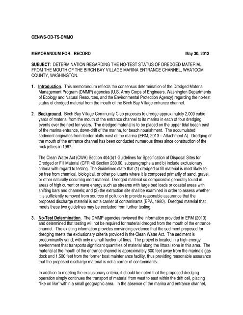
CENWS-OD-TS-DMMO<br />
MEMORANDUM FOR: RECORD May 30, 2013<br />
SUBJECT: DETERMINATION REGARDING THE NO-TEST STATUS OF DREDGED MATERIAL<br />
FROM THE MOUTH OF THE BIRCH BAY VILLAGE MARINA ENTRANCE CHANNEL, WHATCOM<br />
COUNTY, WASHINGTON.<br />
1. Introduction. This memorandum reflects the consensus determination of the Dredged Material<br />
Management Program (DMMP) agencies (U.S. Army Corps of Engineers, Washington Departments<br />
of Ecology and Natural Resources, and the Environmental Protection Agency) regarding the no-test<br />
status of dredged material from the mouth of the <strong>Birch</strong> <strong>Bay</strong> <strong>Village</strong> entrance channel.<br />
2. Background. <strong>Birch</strong> <strong>Bay</strong> <strong>Village</strong> Community Club proposes to dredge approximately 2,000 cubic<br />
yards of material from the mouth of the entrance channel to its marina in each of four dredging<br />
events over the next ten years. The dredged material is to be placed on the upper tidal beach east<br />
of the marina entrance, down-drift of the marina, for beach nourishment. The accumulated<br />
sediment originates from feeder bluffs west of the marina (ERM, 2013 – Attachment A). Dredging of<br />
the mouth of the entrance channel has been conducted numerous times since construction of the<br />
rock jetties in 1967.<br />
The Clean Water Act (CWA) Section 404(b)1 Guidelines for Specification of Disposal Sites for<br />
Dredged or Fill Material (CFR 40 Section 230.60, subparagraphs a and b) include exclusionary<br />
criteria with regard to testing. The Guidelines state that (1) dredged or fill material is most likely to<br />
be free from chemical, biological, or other pollutants where it is composed primarily of sand, gravel,<br />
or other naturally occurring inert material. Dredged material so composed is generally found in<br />
areas of high current or wave energy such as streams with large bed loads or coastal areas with<br />
shifting bars and channels; and (2) the extraction site shall be examined in order to assess whether<br />
it is sufficiently removed from sources of pollution to provide reasonable assurance that the<br />
proposed discharge material is not a carrier of contaminants (EPA, 1980). Dredged material that<br />
meets these two guidelines may be excluded from further testing.<br />
3. No-Test Determination. The DMMP agencies reviewed the information provided in ERM (2013)<br />
and determined that testing will not be required for material dredged from the mouth of the entrance<br />
channel. The existing information provides convincing evidence that the sediment proposed for<br />
dredging meets the exclusionary criteria provided in the Clean Water Act. The sediment is<br />
predominantly sand, with only a small fraction of fines. The project is located in a high-energy<br />
environment that transports significant quantities of material along the littoral zone in this area. The<br />
material at the mouth of the entrance channel is approximately 600 feet away from the marina’s gas<br />
dock and 1,500 feet from the former boat maintenance facility, thus providing reasonable assurance<br />
that the proposed discharge material is not a carrier of contaminants.<br />
In addition to meeting the exclusionary criteria, it should be noted that the proposed dredging<br />
operation simply continues the transport of material from west to east within the drift cell, placing<br />
“like on like” within a small geographic area. In the absence of the marina and entrance channel,
<strong>Birch</strong> <strong>Bay</strong> <strong>Village</strong> <strong>Marina</strong><br />
DMMP No-Test Determination<br />
May 30, 2013<br />
this same west-to-east sediment transport would take place as a result of local hydrodynamic<br />
forces. The dredging operation simply keeps the material moving within the littoral drift cell.<br />
In summary, the DMMP agencies have determined that dredging of the mouth of the entrance<br />
channel to <strong>Birch</strong> <strong>Bay</strong> <strong>Village</strong> <strong>Marina</strong> involves material that meets the exclusionary criteria under the<br />
Clean Water Act and results in “like on like” deposition. Therefore, sediment testing is not required.<br />
4. Geographic Limitation and Reporting.<br />
This determination applies to the mouth of the entrance channel only, and in the absence of<br />
significant changed conditions in the project area during the life of the new permit, this<br />
determination will remain in effect for the full 10 years covered by the permit.<br />
This determination does not apply to sediment north of latitude 48.9322 (see Attachment B). If<br />
dredging is required north of this latitude, additional evaluation may be required. Prior to each<br />
dredging event, <strong>Birch</strong> <strong>Bay</strong> <strong>Village</strong> Community Club must provide a map showing the areas of<br />
proposed dredging and placement. The permit number must be included on the map.<br />
5. References.<br />
ERM, 2012. <strong>Birch</strong> <strong>Bay</strong> <strong>Village</strong> Community Club Maintenance Dredging Permit Renewal.<br />
Memorandum (attached) prepared for the <strong>Birch</strong> <strong>Bay</strong> <strong>Village</strong> Community Club, April 2013.<br />
This determination was coordinated by the undersigned with Laura Inouye (Ecology), Justine Barton<br />
(EPA) and Celia Barton (DNR).<br />
___________<br />
Date<br />
________________________________________________<br />
David Fox, P.E. - <strong>Seattle</strong> <strong>District</strong> Corps of Engineers<br />
Copies furnished:<br />
Ken Hoffer, BBVCC<br />
Michelle Fisher, ERM<br />
Justine Barton, EPA<br />
Laura Inouye, Ecology<br />
Celia Barton, DNR<br />
Randel Perry, <strong>Seattle</strong> <strong>District</strong> Regulatory<br />
Page 2 of 2
Memorandum<br />
To:<br />
From:<br />
David Fox, U.S. Army Corps of Engineers and<br />
Dredge Material Management Office<br />
Michelle Fisher, ERM, prepared for<br />
<strong>Birch</strong> <strong>Bay</strong> <strong>Village</strong> Community Club<br />
Environmental<br />
Resources<br />
Management<br />
2211 Rimland Dr.<br />
Suite 210<br />
Bellingham, WA 98226<br />
(360) 647-3900<br />
(360) 647-3901 (fax)<br />
Date: April 19, 2013, Revision 1 submitted April 25, 2013<br />
Subject:<br />
Maintenance Dredging Permit Renewal<br />
ERM, West Inc. (ERM) is providing this memo on behalf of the <strong>Birch</strong> <strong>Bay</strong><br />
<strong>Village</strong> Community Club (BBVCC). BBVCC is preparing permit<br />
applications to continue periodic dredging of native materials that<br />
accumulate at the entrance to their marina. This memo is a request to the<br />
Dredge Material Management Office (DMMO) to exclude the project from<br />
the sediment testing requirement.<br />
As requested by Mr. Dave Fox in a phone conversation March 25, 2013,<br />
this memo includes a project description, site and dredging history, a<br />
sediment description, sediment source, potential contamination sources,<br />
and a summary of ERM’s reasons for asking that the sediments proposed<br />
for dredging be excluded from testing.<br />
PROJECT DESCRIPTION<br />
The BBVCC dredging site is located on the northwest shore of <strong>Birch</strong> <strong>Bay</strong><br />
approximately 2 miles east of <strong>Birch</strong> Point. The site contains an artificial<br />
entrance channel for a pleasure boat marina located inland.<br />
BBVCC is seeking new permits to dredge the same area as previously<br />
permitted (2001-2-00437) at the mouth of the entrance channel. This area<br />
has had periodic maintenance dredging since the marina’s construction,<br />
and is due for dredging again in fall 2014. The dredging is needed to<br />
maintain adequate water depths for boats accessing the marina.<br />
BBVCC is proposing to dredge to -10 MLLW of less than 2,000 cy in each<br />
dredging event (four times over the permit period). This larger volume is<br />
based on a prediction in the 2001 Coastal Processes Study by Coastal<br />
Geologic Services, Inc. (CGS) that a greater volume of sediment will<br />
accumulate over time in the decades subsequent to the study.<br />
BBVCC also plans to place the dredged materials for beach nourishment<br />
as requested by Washington Department of Fish and Wildlife (WDFW)<br />
and <strong>Whatcom</strong> <strong>County</strong>. Since 2001, BBVCC has placed these dredged<br />
materials on the upper tidal beach east of the marina entrance down-drift<br />
of the marina.<br />
A member of the Environmental<br />
Resources Management Group
P A G E 2<br />
DREDGE HISTORY<br />
The entrance channel to the marina was constructed in 1967 with rock<br />
jetties on both sides. Sedimentation within the entrance channel occurs<br />
through longshore transport of drift material from west of the channel<br />
entrance.<br />
The following table contains the dredging history of the channel entrance.<br />
Dredging was authorized by the Corps of Engineers most recently with a<br />
10-year individual permit for the period 2001 to 2011.<br />
Dredge History<br />
Year Dredge Volume Year Dredge Volume<br />
1967 Jetties built 1994 1,000 cy<br />
1968-1980 2 times - unknown volume 2002 1,000 cy<br />
1981 938 cy 2005 1,000 cy<br />
1986 938 cy 2008 1,000 cy<br />
1990 1,000 cy 2011 1,000 cy<br />
SEDIMENT SOURCE<br />
In 2001, Coastal Geologic Services (CGS) studied the sediment drift<br />
pattern and source. The following information is taken from this study.<br />
The <strong>Birch</strong> <strong>Bay</strong> <strong>Village</strong> <strong>Marina</strong> entrance is exposed to northeasterly winds.<br />
A long fetch from the southwest allows such winds to build up relatively<br />
high-energy waves. The proposed project area occurs in the middle of a<br />
west-to-east drift sector, in which the natural longshore movement of<br />
material is from west to east from <strong>Birch</strong> Point to Cottonwood Beach in<br />
northernmost <strong>Birch</strong> <strong>Bay</strong> (Schwartz et al. 1991 cited in CGS 2001). The<br />
channel entrance, with jetties on either side, interrupts the longshore drift<br />
of material from west to east and has reduced the main supply of drift<br />
material to the shoreline east of the entrance (CGS 2001).<br />
An extensive feeder bluff that starts approximately one-quarter mile west<br />
and continues north along the shoreline provides the fine-grained material<br />
to the project area through natural erosion processes (CGS 2001). The<br />
entrance channel is a deposition area for sediment transported eastward<br />
from these bluffs west of the marina. The beach east of the jetties is in need<br />
of more sediment, and benefits from the dredge sediment.<br />
Along the beach to the east of the jetty, up to 4 feet of vertical erosion may<br />
have occurred since construction of the channel in 1967. During this time,
P A G E 3<br />
substrate along the beach changed from a mixed sand and gravel beach to<br />
a cobble beach. The beach to the east of the jetty is comprised primarily of<br />
cobble 3 to 6 inches in diameter. Some bulkheads bordering shoreline<br />
residences to the east have been scoured out at their base. In an effort to<br />
relieve concerns about bulkheads to the east of the marina entrance,<br />
WDFW and <strong>Whatcom</strong> <strong>County</strong> Planning Department have encouraged the<br />
Community Club to use the dredge material for beach nourishment or<br />
potentially implement a separate beach nourishment program.<br />
SEDIMENT DESCRIPTION<br />
In 2001, CGS also conducted sediment sampling that characterized the<br />
grain size of the sediments in the outer entrance channel. Several sediment<br />
samples from the main shoal area (east of the waterward end of the west<br />
jetty). Sample collection was from the -1 to -3 feet MLLW elevation. These<br />
samples were sub-sampled and combined into one integrated channel<br />
sample for grain size analysis. Results of the grain size analysis are<br />
presented in the table below. There was a moderate amount of shell<br />
fragment in the smaller pebble and very coarse sand fraction, although<br />
the weight of shell fragment was estimated at less than 25 percent of<br />
these size classes. The sediment in the entrance channel consisted of<br />
73 percent coarse and very coarse sand. The sample contained 7.1<br />
percent gravel and 20.1 percent medium to very fine sand and silt.<br />
<strong>Entrance</strong> Channel Sediment Characterization 1<br />
Sediment Grain Size<br />
Channel Dredge Area Integrated Sample<br />
Wentworth Scale Inches % Frequency<br />
(-) 6 phi, (>64 mm) cobble >2.5 0.0%<br />
(-) 5 phi, (32-64 mm) cobble 1.25 - 2.5 0.0%<br />
(-) 4 phi, (16-32mm) pebble 0.6 - 1.25 1.1%<br />
(-) 3 phi, (8-16 mm) pebble 0.3 - 0.6 1.1%<br />
(-) 2 phi, (4-8 mm) pebble 0.16 - 0.3 1.6%<br />
(-) 1 phi, (2-4 mm) granule 0.08 - 0.16 3.3%<br />
O phi, (1-2 mm) v.cs. sand 0.04 - 0.08 5.0%<br />
(+)1 phi, (0.5-1 mm) cs. Sand 0.02 - 0.08 67.8%<br />
P A G E 4<br />
The amount of silt was fairly low and represents a much lesser<br />
proportion than nearby bluff deposits contain. Therefore the minor<br />
amount of fine sand and silt in the dredge area would pose less potential<br />
“harm” in terms of siltation than would a single moderate-large<br />
landslide, an occurrence that is fairly common only several thousand feet<br />
up-drift of the entrance channel (CGS 2001).<br />
Note that CGS classified the sediments
P A G E 5<br />
ERM also looked at DMMO determinations from nearby Semiahmoo<br />
<strong>Marina</strong> in Drayton Harbor (December 29, 2007) which is about 4.5 miles<br />
north, and the Point Roberts <strong>Marina</strong> (December 8, 2005) which is about 8<br />
miles northwest. In both marina examples, the dredged materials were<br />
tested and found suitable for open water disposal and sediment bypass<br />
operations, providing additional evidence of the low risk posed by<br />
sediments in the project vicinity. The sediment bypass operation at Point<br />
Roberts was recently given a no-test determination based, in part, on this<br />
low risk (May 10, 2012).<br />
SUMMARY<br />
The source of sediment that needs periodic dredging to maintain access<br />
through the marina’s entrance channel is native material from feeder<br />
bluffs to the west. Accumulations of this native material across the<br />
entrance channel require maintenance dredging approximately every 3<br />
years. The cumulative dredging volume over the course of a 10-year<br />
permit cycle is estimated to be less than 8,000 cy.<br />
The sediments proposed for dredging are not proximate to potential<br />
sources of contamination, the silt and clay fractions of the sediment are<br />
less than 20 percent, and the site was described as having high-energy<br />
waves. Sediment quality data from other studies have shown <strong>Birch</strong> <strong>Bay</strong><br />
sediment to contain very low contaminant concentrations (less than SQS).<br />
ERM believes that these circumstances warrant a Low ranking for the<br />
project and that the <strong>Birch</strong> <strong>Bay</strong> <strong>Village</strong> Community Club dredging project<br />
can be excluded from testing.<br />
REFERENCES<br />
Dredged Material Management Program [DMMP]. 2005. Determination of<br />
the Suitability of Sediment Proposed to be Maintenance Dredged from<br />
Point Roberts <strong>Marina</strong>, Point Roberts, Washington for Open-Water<br />
Disposal at the Washington State Department of Natural Resources (DNR)<br />
Rosario Strait PSDDA Open Water Disposal Site, as Evaluated Under<br />
Section 404 of the Clean Water Act. Prepared by the Dredged Material<br />
Management Office for the Dredged Material Management Program<br />
agencies, December 2005.<br />
_______. 2007. Determination Regarding the Suitability of Proposed<br />
Dredged Material from Semiahmoo <strong>Marina</strong>, Blaine, Washington, for<br />
Unconfined Open-Water Disposal at the Rosario Strait Dispersive Site or
P A G E 6<br />
Beneficial Use. Prepared by the Dredged Material Management Office for<br />
the Dredged Material Management Program agencies, December 2007.<br />
_______. 2012. Determination Regarding the Exclusionary Status of<br />
Dredged Material From the Point Roberts <strong>Marina</strong> Bypass Operation,<br />
<strong>Whatcom</strong> <strong>County</strong>, Washington. Prepared by the Dredged Material<br />
Management Office for the Dredged Material Management Program<br />
agencies, May 2012.<br />
_______. 2013. Dredged Material Evaluation and Disposal Procedures<br />
(User’s Manual). Dredged Material Management Program, July 2008 as<br />
revised January 24, 2013.<br />
Ecology. See Washington Department of Ecology.<br />
Johannessen, J. 2001. <strong>Birch</strong> <strong>Bay</strong> <strong>Village</strong> Community Club <strong>Marina</strong>: Coastal<br />
Processes Study and Analysis of Options for Dredge Spoils<br />
Disposal/Beach Nourishment. Coastal Geological Services, Inc., prepared<br />
for Anvil Corporation February 9, 2001.<br />
Poppe, L.J., A.H. Eliason, J.J. Fredericks, R.R. Rendigs, D. Blackwood, and<br />
C.F. Polloni. 2013. USGS East-Coast Sediment Analysis: Procedures,<br />
Database, and Georeferenced Displays, Chapter 1: Grain-Size Analysis of<br />
Marine Sediments - Methodology and Data Processing. U.S. Geological<br />
Survey Open-File Report 00-358. Website: http://pubs.usgs.gov/of/<br />
2000/of00-358/text/contents.htm. Accessed March 2013.<br />
U.S. Environmental Protection Agency. 2008. Puget Sound Sediment<br />
Sampling Data taken from EPA’s Survey Vessel, the Bold. Website:<br />
http://www.epa.gov/pugetsound /bold.html. Accessed April 2013.<br />
Washington Department of Ecology [Ecology]. 2012. Sediment Quality<br />
Assessment of the Southern Strait of Georgia, 2006. Department of<br />
Ecology Publication No. 12-03-001, February 2012. Website: https://<br />
fortress.wa.gov/ecy/publications/publications/1203001.pdf. Accessed<br />
April 12, 2013.<br />
FIGURES<br />
Figure 1. Vicinity Map<br />
Figure 2. Ecology Sediment Sampling Sites<br />
APPENDICES<br />
Coastal Geologic Services Report
*<br />
Project Location<br />
Latitude: 48° 56' 12"<br />
Longitude: 122° 47' 2"<br />
F:\GIS\Projects\<strong>Birch</strong><strong>Bay</strong>\ArcMaps\BB_SiteLocationMap.mxd WESAC JA 4/19/2013<br />
Site Location is Approximately 4 miles<br />
Southwest of the City of Blaine, WA.<br />
Directions to Site:<br />
Travelling north or south I-5, take Exit 270. Head West on <strong>Birch</strong> <strong>Bay</strong>-Lynden<br />
Road to Harborview Road. Turn left on Harborview Road to <strong>Birch</strong> <strong>Bay</strong> Drive.<br />
Turn right on <strong>Birch</strong> <strong>Bay</strong> Drive and proceed 2 miles to north <strong>Entrance</strong> of<br />
<strong>Birch</strong> <strong>Bay</strong> <strong>Village</strong>. After entering village proceed south on Sehome Road.<br />
Turn right on Cowichan Road. Proceed to <strong>Marina</strong>. The project is located<br />
at the <strong>Marina</strong> Channel entrance.<br />
Service Layer Credits: Sources: Esri, DeLorme, NAVTEQ, TomTom, Intermap, increment P Corp., GEBCO, USGS, FAO, NPS, NRCAN,<br />
GeoBase, IGN, Kadaster NL, Ordnance Survey, Esri Japan, METI, Esri China (Hong Kong), swisstopo, and the GIS User Community<br />
¯<br />
0 2<br />
4<br />
Scale in Kilometers<br />
0 1<br />
2<br />
Scale in Miles<br />
1 inch = 1 mile<br />
Figure 1<br />
Site Location Map<br />
<strong>Birch</strong> <strong>Bay</strong> <strong>Village</strong> Community Club<br />
Blaine, WA<br />
PREPARED BY:<br />
JA (ERM)<br />
Job No.: 105449<br />
File: BB_SiteLocationMap.mxd
122°47'24"W<br />
122°47'18"W<br />
122°47'12"W<br />
122°47'6"W<br />
122°47'0"W<br />
122°46'54"W<br />
122°46'48"W<br />
122°46'42"W<br />
122°46'36"W<br />
122°46'30"W<br />
122°46'24"W<br />
122°46'18"W<br />
122°46'12"W<br />
48°56'12"N<br />
Former Boat<br />
Maintenance Facility<br />
Legend<br />
&< 2006 Dept. of Ecology Sampling Location<br />
Pre-2014 Dredge Contours March 2013<br />
2000-2005 Bathymetry<br />
Proposed 2014 Dredge Volume Area<br />
Gas Dock<br />
48°55'48"N<br />
48°55'54"N<br />
48°56'0"N<br />
48°55'42"N<br />
48°55'36"N<br />
48°56'6"N<br />
\\wdsacdc01\dataSAC\GIS\Projects\<strong>Birch</strong><strong>Bay</strong>\ArcMaps\BB_2006SamplingLocations.mxd WESAC 4/17/2013<br />
&<<br />
3, <strong>Birch</strong> <strong>Bay</strong><br />
Latitude: 48 55.7973, Longitude: -122 46.8563<br />
125, <strong>Birch</strong> <strong>Bay</strong><br />
Latitude: 48 55.6431, Longitude: -122 46.2477<br />
Service Layer Credits: Copyright:© 2013 Esri, DeLorme, NAVTEQ, TomTom<br />
Source: Esri, DigitalGlobe, GeoEye, i-cubed, USDA, USGS, AEX, Getmapping, Aerogrid, IGN, IGP, swisstopo, and the GIS User Community<br />
&<<br />
¯<br />
0 400<br />
Scale in Feet<br />
<strong>Birch</strong> <strong>Bay</strong> <strong>Village</strong> Community Club<br />
PREPARED BY:<br />
(ERM)<br />
Figure 2<br />
2014 <strong>Marina</strong> Maintenance<br />
Dredging Project<br />
Nearest Sediment<br />
Sampling Sites<br />
JOB NO. 191928<br />
FILE: BB_2006SamplingLocations.mxd<br />
122°47'24"W<br />
122°47'18"W<br />
122°47'12"W<br />
122°47'6"W<br />
122°47'0"W<br />
122°46'54"W<br />
122°46'48"W<br />
122°46'42"W<br />
122°46'36"W<br />
122°46'30"W<br />
122°46'24"W<br />
122°46'18"W<br />
122°46'12"W
122°47'24"W<br />
122°47'18"W<br />
122°47'12"W<br />
122°47'6"W<br />
122°47'0"W<br />
122°46'54"W<br />
122°46'48"W<br />
122°46'42"W<br />
122°46'36"W<br />
122°46'30"W<br />
122°46'24"W<br />
122°46'18"W<br />
122°46'12"W<br />
48°56'12"N<br />
Former Boat<br />
Maintenance Facility<br />
Legend<br />
&< 2006 Dept. of Ecology Sampling Location<br />
Pre-2014 Dredge Contours March 2013<br />
2000-2005 Bathymetry<br />
Proposed 2014 Dredge Volume Area<br />
Gas Dock<br />
48°55'48"N<br />
48°55'54"N<br />
48°56'0"N<br />
48°55'42"N<br />
48°55'36"N<br />
48°56'6"N<br />
\\wdsacdc01\dataSAC\GIS\Projects\<strong>Birch</strong><strong>Bay</strong>\ArcMaps\BB_2006SamplingLocations.mxd WESAC 4/17/2013<br />
&<<br />
3, <strong>Birch</strong> <strong>Bay</strong><br />
Latitude: 48 55.7973, Longitude: -122 46.8563<br />
125, <strong>Birch</strong> <strong>Bay</strong><br />
Latitude: 48 55.6431, Longitude: -122 46.2477<br />
Service Layer Credits: Copyright:© 2013 Esri, DeLorme, NAVTEQ, TomTom<br />
Source: Esri, DigitalGlobe, GeoEye, i-cubed, USDA, USGS, AEX, Getmapping, Aerogrid, IGN, IGP, swisstopo, and the GIS User Community<br />
&<<br />
¯<br />
0 400<br />
Scale in Feet<br />
<strong>Birch</strong> <strong>Bay</strong> <strong>Village</strong> Community Club<br />
PREPARED BY:<br />
(ERM)<br />
Figure 2<br />
2014 <strong>Marina</strong> Maintenance<br />
Dredging Project<br />
Nearest Sediment<br />
Sampling Sites<br />
JOB NO. 191928<br />
FILE: BB_2006SamplingLocations.mxd<br />
122°47'24"W<br />
122°47'18"W<br />
122°47'12"W<br />
122°47'6"W<br />
122°47'0"W<br />
122°46'54"W<br />
122°46'48"W<br />
122°46'42"W<br />
122°46'36"W<br />
122°46'30"W<br />
122°46'24"W<br />
122°46'18"W<br />
122°46'12"W