Adaptive Crop Agriculture Including Innovative Farming Practices in ...
Adaptive Crop Agriculture Including Innovative Farming Practices in ...
Adaptive Crop Agriculture Including Innovative Farming Practices in ...

Create successful ePaper yourself
Turn your PDF publications into a flip-book with our unique Google optimized e-Paper software.
1. Introduction<br />
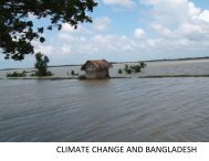
The northeastern part of Bangladesh has a unique landscape, where natural pattern of<br />
flood<strong>in</strong>g has created very productive fisheries <strong>in</strong> the wet season, and allowed rice to grow <strong>in</strong><br />
the dry season. The productivity of this wetland (Haor) has contributed to be food surplus of<br />
this region, and there is a potentiality for further <strong>in</strong>creases of land for agriculture. However,<br />
change of flood tim<strong>in</strong>g and pattern is probably one of the ma<strong>in</strong> reasons for chang<strong>in</strong>g local<br />
ecosystem and the livelihood of the local people. In Sunamgangj district, flashflood causes<br />
crop damage which is considered as a big threat to the people, especially who work as<br />
sharecroppers or landless laborers. Sometimes, the flashflood comes early, just before the rice<br />
harvest<strong>in</strong>g and dur<strong>in</strong>g that time the people of haor bas<strong>in</strong>, do not even get the time to harvest<br />
their crops. In many cases, it has been found that this part of Bangladesh losses 100% of its<br />
crops.<br />
Threats to local livelihoods are not solely conf<strong>in</strong>ed to wet season catastrophes. Dur<strong>in</strong>g the dry<br />
season, the water-covered area is reduced by significant amount and turns <strong>in</strong>dividual small<br />
water bodies called beels and kuas as well as lakes and canals. These separated water bodies<br />
are vital for breed<strong>in</strong>g and ma<strong>in</strong>ta<strong>in</strong><strong>in</strong>g stocks of fish.<br />
The Haor Bas<strong>in</strong> is close to the Indian border and Meghalaya Hills where deforestation<br />
(natural & manmade) is happen<strong>in</strong>g everyday. Other climatic changes have also contributed <strong>in</strong><br />
degrad<strong>in</strong>g the eco-system that causes severity of flash floods <strong>in</strong> the haor areas. Ra<strong>in</strong>falls <strong>in</strong><br />
Megahalaya have <strong>in</strong>creased <strong>in</strong> the recent years compared to 30 years back. This has an impact<br />
over the early flashflood <strong>in</strong> Jamalganj area. This report is to identify the major problems for<br />
the local people and also to f<strong>in</strong>d out a way to <strong>in</strong>crease the options of their livelihood.<br />
Upstream communities also contribute pollution loads <strong>in</strong> the bas<strong>in</strong>, re-vegetat<strong>in</strong>g local areas<br />
have been critical to protect them. Trans-boundary issues to be addressed for better watershed<br />
management. The biodiversity will benefit establish<strong>in</strong>g conservation areas to protect the<br />
threatened species.<br />
1.1 Background<br />
The hydrological regime of the haor bas<strong>in</strong> has changed over years. Various factors are<br />
responsible for such changes; deforestation <strong>in</strong> both haor bas<strong>in</strong> and <strong>in</strong> upstream of Meghalaya<br />
Hills <strong>in</strong> India is certa<strong>in</strong>ly one of the prime reasons <strong>in</strong> this regard. Changes of other climatic<br />
parameters may have contributed <strong>in</strong> the change of hydrological regime of the haor areas. The<br />
flash flood generally occurs after mid April due to heavy ra<strong>in</strong>fall <strong>in</strong> the hills of Meghalaya,<br />
India. In recent years, flashflood hit Sunamganj district and other haor areas fifteen days<br />
earlier than thirty to forty years back. Thirty years before, flashflood used to hit border areas<br />
of Sunamganj and took three-five days to reach Tahirpur and seven-fifteen days to reach the<br />
haor of Jamalganj Upazilla while <strong>in</strong> the present situation, it takes one day and 3-5 days<br />
respectively (source: previous study of CNRS). Forest <strong>in</strong> the hilly areas and haor bas<strong>in</strong> used<br />
to slow down the flow of water, and more water were seeped <strong>in</strong>to local soils for storage. Now<br />
due to deforestation <strong>in</strong> Indian hills and haor bas<strong>in</strong> flash flood hits Jamalganj ten to fifteen<br />
days earlier. Siltation <strong>in</strong> rivers, canals, and haors has raised the haor and riverbeds. As a<br />
result, the rivers and canals cannot hold much water, and severity of flood <strong>in</strong>tensifies. Rivers<br />
also are unable to dra<strong>in</strong> much water to Meghna river system. On the other hand, local farmer<br />
switched to cultivate HYV rice (BR 29) from local boro rice variety. BR 29 takes about 30<br />
1