A GIS based approach to restoring connectivity across Banff's Trans ...
A GIS based approach to restoring connectivity across Banff's Trans ...
A GIS based approach to restoring connectivity across Banff's Trans ...

Create successful ePaper yourself
Turn your PDF publications into a flip-book with our unique Google optimized e-Paper software.
If we cannot maintain all <strong>connectivity</strong> in the valley (i.e.<br />
100 percent of habitat potential), then the sites we have<br />
selected (i.e. the upper 20 percent) represent the<br />
minimum amount that should be maintained as linkages.<br />
If properly mitigated, these linkage zones have the<br />
greatest likelihood of maintaining <strong>connectivity</strong>. It must<br />
be noted that the 20-percent threshold was arbitrarily<br />
defined and should be a point of discussion among<br />
stakeholders, especially the public, <strong>to</strong> determine what is<br />
the minimum “acceptable” range of habitat <strong>to</strong> protect in<br />
a national park.<br />
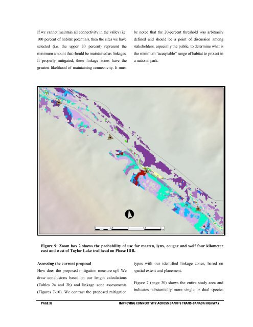
Figure 9: Zoom box 2 shows the probability of use for marten, lynx, cougar and wolf four kilometer<br />
east and west of Taylor Lake trailhead on Phase IIIB.<br />
Assessing the current proposal<br />
How does the proposed mitigation measure up? We<br />
draw conclusions <strong>based</strong> on our length calculations<br />
(Tables 2a and 2b) and linkage zone assessments<br />
(Figures 7-10). We contrast the proposed mitigation<br />
types with our identified linkage zones, <strong>based</strong> on<br />
spatial extent and placement.<br />
Figure 7 (page 30) shows the entire study area and<br />
indicates substantially more single or dual species<br />
PAGE 32<br />
IMPROVING CONNECTIVITY ACROSS BANFF’S TRANS-CANADA HIGHWAY