Maple Bay Farm Site Information and History Page 1 of 6 Maple Bay ...
Maple Bay Farm Site Information and History Page 1 of 6 Maple Bay ...
Maple Bay Farm Site Information and History Page 1 of 6 Maple Bay ...

Create successful ePaper yourself
Turn your PDF publications into a flip-book with our unique Google optimized e-Paper software.
<strong>Maple</strong> <strong>Bay</strong> <strong>Farm</strong> <strong>Site</strong> <strong>Information</strong> <strong>and</strong> <strong>History</strong><br />
<strong>Maple</strong> <strong>Bay</strong> <strong>Farm</strong> Planning Process<br />
The staff <strong>of</strong> the Gr<strong>and</strong> Traverse Regional L<strong>and</strong> Conservancy (GTRLC) implemented an 18-month data<br />
gathering <strong>and</strong> planning process timeframe to evaluate the potential for future opportunities <strong>and</strong><br />
partnerships at <strong>Maple</strong> <strong>Bay</strong> <strong>Farm</strong>, an 11 acre parcel located along North US 31 in Acme Township (GT<br />
County, Section 7, T28N, R9W). The decision making criteria developed by GTRLC staff <strong>and</strong> board<br />
include the GTRLC’s goals <strong>and</strong> needs related to outreach, financial <strong>and</strong> organizational sustainability, <strong>and</strong><br />
goals <strong>and</strong> needs related to l<strong>and</strong> management practices.<br />
Based on the criteria, GTRLC invites proposals from organizations <strong>and</strong> individuals. An Ad Hoc <strong>Maple</strong><br />
<strong>Bay</strong> <strong>Farm</strong> Leadership Committee <strong>of</strong> board <strong>and</strong> staff members will then review partnership proposals. The<br />
anticipated timeline for implementation <strong>and</strong> partnership decisions will be by the spring <strong>of</strong> 2013.<br />
Since we acquired the property in 2002, we recognize that some community members <strong>and</strong> stakeholders<br />
have approached the GTRLC to share their ideas for potential programs <strong>and</strong> partnerships that they would<br />
like to see implemented at <strong>Maple</strong> <strong>Bay</strong> <strong>Farm</strong>. This GTRLC led planning process will provide a framework<br />
to evaluate <strong>and</strong> pursue possible activities at <strong>Maple</strong> <strong>Bay</strong> <strong>Farm</strong>.<br />
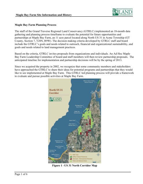
Figure 1 –US 31 North Corridor Map<br />
<strong>Page</strong> 1 <strong>of</strong> 6
<strong>Maple</strong> <strong>Bay</strong> <strong>Farm</strong> <strong>Site</strong> <strong>Information</strong> <strong>and</strong> <strong>History</strong><br />
<strong>Maple</strong> <strong>Bay</strong> <strong>Farm</strong> <strong>and</strong> the <strong>Maple</strong> <strong>Bay</strong> Natural Area Overview<br />
The entire <strong>Maple</strong> <strong>Bay</strong> Conservation project features 2,583 feet <strong>of</strong> s<strong>and</strong> <strong>and</strong> cobble beach on Gr<strong>and</strong><br />
Traverse East <strong>Bay</strong>, rare <strong>and</strong> threatened species, coastal wetl<strong>and</strong>s, open <strong>and</strong> forested dunes, <strong>and</strong> farm l<strong>and</strong>.<br />
The <strong>Maple</strong> <strong>Bay</strong> <strong>Farm</strong> <strong>and</strong> the Gr<strong>and</strong> Traverse County <strong>Maple</strong> <strong>Bay</strong> Park <strong>and</strong> Natural Area embodies the<br />
essence <strong>of</strong> northern Michigan <strong>and</strong> the spirit <strong>of</strong> the Conservancy’s mission: to protect significant natural,<br />
scenic, <strong>and</strong> farml<strong>and</strong>s, <strong>and</strong> advance stewardship, now <strong>and</strong> for all future generations.<br />
Although the <strong>Maple</strong> <strong>Bay</strong> conservation site is a microcosm on its own, it is even more significant in the<br />
context <strong>of</strong> the l<strong>and</strong>scape on which it sits. It stretches from its pristine shoreline on East Gr<strong>and</strong> Traverse<br />
<strong>Bay</strong> inl<strong>and</strong> to the Petobego Marsh <strong>and</strong> is adjacent to the Petobego State Game Area. The protection <strong>of</strong><br />
<strong>Maple</strong> <strong>Bay</strong> has greatly enhanced conservation <strong>of</strong> the Petobego Creek corridor <strong>and</strong> 42 acres <strong>of</strong> the former<br />
farm have been added to the State Game area in partnership with the Michigan Department <strong>of</strong> Natural<br />
Resources. There are over 1200 acres <strong>of</strong> permanently protected l<strong>and</strong>s within a two-mile radius, including;<br />
the Yuba Valley Natural Area, Petobego Creek Natural area, <strong>and</strong> two private properties protected through<br />
conservation agreements with GTRLC (Figure 1).<br />
In conjunction with the protection <strong>of</strong> the natural l<strong>and</strong>s, the work that Acme Township <strong>and</strong> the GTRLC are<br />
doing to protect farml<strong>and</strong> in the township will result in one <strong>of</strong> the most comprehensive l<strong>and</strong>scape level<br />
conservation efforts in the nation. The farming belt along US-31 in Gr<strong>and</strong> Traverse <strong>and</strong> Antrim Counties<br />
are part <strong>of</strong> the west Michigan fruit belt, a keystone economic <strong>and</strong> cultural asset <strong>of</strong> our region. <strong>Maple</strong> <strong>Bay</strong><br />
<strong>and</strong> Acme Township provide the anchor for preservation efforts to protect this vital resource for our<br />
community <strong>and</strong> the State.<br />
<strong>Maple</strong> <strong>Bay</strong> <strong>Farm</strong> Introduction<br />
The following is a report <strong>of</strong> current site information <strong>and</strong> l<strong>and</strong> history to provide the reader with certain<br />
baseline data <strong>and</strong> facts related to the <strong>Maple</strong> <strong>Bay</strong> <strong>Farm</strong> <strong>and</strong> the <strong>Maple</strong> <strong>Bay</strong> Park <strong>and</strong> Natural Area. This<br />
report includes some detail about the acquisition history <strong>and</strong> funding for the entire 460 acre <strong>Maple</strong> <strong>Bay</strong><br />
conservation project, the remainder <strong>of</strong> the report narrows the scope to the 11 acres owned <strong>and</strong> managed by<br />
the Gr<strong>and</strong> Traverse Regional L<strong>and</strong> Conservancy (GTRLC) <strong>and</strong> includes the farmhouse <strong>and</strong> outbuildings<br />
located west <strong>of</strong> US-31 <strong>and</strong> identified in the map below (Figure 2). Future programs <strong>and</strong> projects that may<br />
be implemented on the GTRLC <strong>Maple</strong> <strong>Bay</strong> <strong>Farm</strong> property will be considerate <strong>of</strong> the greater management<br />
<strong>of</strong> the <strong>Maple</strong> <strong>Bay</strong> Park <strong>and</strong> Natural Area. For information about the Gr<strong>and</strong> Traverse County <strong>Maple</strong> <strong>Bay</strong><br />
Park <strong>and</strong> Natural Area Master Plan, see Appendix B or contact the Gr<strong>and</strong> Traverse County Director <strong>of</strong><br />
Parks <strong>and</strong> Recreation.<br />
<strong>Page</strong> 2 <strong>of</strong> 6
<strong>Maple</strong> <strong>Bay</strong> <strong>Farm</strong> <strong>Site</strong> <strong>Information</strong> <strong>and</strong> <strong>History</strong><br />
Acquisition <strong>History</strong><br />
Figure 2– <strong>Maple</strong> <strong>Bay</strong> <strong>Farm</strong> Aerial<br />
In 2001, the Rollert family decided to sell their spectacular 460-acre farm. Because <strong>of</strong> the uniqueness <strong>of</strong><br />
<strong>Maple</strong> <strong>Bay</strong>, GTRLC acted quickly for the permanent protection <strong>of</strong> the property. Thanks to a partnership<br />
with the Rollert family, Gr<strong>and</strong> Traverse County, <strong>and</strong> generous funding from the Michigan Natural<br />
Resources Trust Fund ($6,800,000), Coastal Zone Management Program ($500,000), North America<br />
Wetl<strong>and</strong> Conservation Act ($500,000), Federal Wetl<strong>and</strong> Reserve Program ($273,000), <strong>and</strong> many<br />
individuals <strong>and</strong> private foundations ($410,000), GTRLC was able to ensure that this unique piece <strong>of</strong> our<br />
l<strong>and</strong>scape, which provides high quality habitat for rare <strong>and</strong> threatened species <strong>and</strong> is refuge to countless<br />
migratory birds, will be open for current <strong>and</strong> future generations to enjoy. Each <strong>of</strong> these grants aimed to<br />
preserve a specific characteristic <strong>of</strong> the property (e.g. wetl<strong>and</strong>s, public access, etc.,) <strong>and</strong> sets specific<br />
parameters for the use <strong>of</strong> the property.<br />
Today, the former <strong>Maple</strong> <strong>Bay</strong> dairy farm is one <strong>of</strong> the premier conservation areas in the Gr<strong>and</strong> Traverse<br />
region. As an outcome <strong>of</strong> the l<strong>and</strong> protection efforts, 42 acres were added to the Petobego State Game<br />
Area, while Gr<strong>and</strong> Traverse County owns the 400-acre <strong>Maple</strong> <strong>Bay</strong> Park <strong>and</strong> Natural Area <strong>and</strong> recently<br />
completed a master plan for the property in 2008. Recognizing that the MNRTF <strong>and</strong> other funding<br />
<strong>Page</strong> 3 <strong>of</strong> 6
<strong>Maple</strong> <strong>Bay</strong> <strong>Farm</strong> <strong>Site</strong> <strong>Information</strong> <strong>and</strong> <strong>History</strong><br />
sources did not favor their grant monies to go toward the purchase <strong>of</strong> improvements that did not enhance<br />
the recreational opportunities <strong>of</strong> the project, the remaining 16-acre parcels, which included an old<br />
farmhouse, was purchased by GTRLC.<br />
In the summer <strong>of</strong> 2006, GTRLC undertook a $70,000 initiative to improve access to the <strong>Maple</strong> <strong>Bay</strong> <strong>Farm</strong>.<br />
Several old pole buildings were dismantled <strong>and</strong> were re-used by area farmers <strong>and</strong> a new driveway was<br />
installed. Upon completion <strong>of</strong> this project, the GTRLC conveyed 5 acres that included the new access<br />
drive to Gr<strong>and</strong> Traverse County in the spring <strong>of</strong> 2007.<br />
Today, the old farmhouse <strong>and</strong> the 11 surrounding acres sit vacant until GTRLC develops a plan to use the<br />
buildings <strong>and</strong> the l<strong>and</strong> to further our mission.<br />
Vegetation Overview<br />
Based upon General L<strong>and</strong> Office Surveys from the 1800’s, the 11 acres owned by GTRLC was originally<br />
part <strong>of</strong> a large Beech-Sugar <strong>Maple</strong>-Hemlock Forest complex. By the turn <strong>of</strong> the century the property had<br />
been converted to farml<strong>and</strong> <strong>and</strong> residential uses. As a result, a majority <strong>of</strong> the plants at the preserve are<br />
non-native, however, <strong>of</strong> those nonnative plants only a small percentage are considered invasive. Plants<br />
used for l<strong>and</strong>scaping purposes are found near the house area <strong>and</strong> include introduced species <strong>of</strong> lawn grass,<br />
trees, shrubs, <strong>and</strong> flowers.<br />
Agricultural fields constitute a majority <strong>of</strong> the preserve <strong>and</strong> have historically consisted <strong>of</strong> corn,<br />
sunflowers, alfalfa <strong>and</strong> cool season grasses. A local farm family, who has an agreement with the County,<br />
farms the <strong>Maple</strong> <strong>Bay</strong> Park <strong>and</strong> Natural Area <strong>and</strong> this agreement extends to the contiguous GTRLC<br />
agricultural property.<br />
A small, perched wetl<strong>and</strong>, nearly .15 acres in size, remains near the entrance <strong>of</strong> the preserve <strong>and</strong> is<br />
adjacent to the driveway <strong>and</strong> sunflower field. The open wetl<strong>and</strong> has the highest percentage <strong>of</strong> native<br />
plants <strong>and</strong> is comprised <strong>of</strong> common wetl<strong>and</strong> species such as cat-tail (Typha latifolia), Epilobium sp., <strong>and</strong><br />
Juncus effusus <strong>and</strong> Carex vulpinoidea. The wetl<strong>and</strong> is part <strong>of</strong> a larger wetl<strong>and</strong> area that extends onto the<br />
Gr<strong>and</strong> Traverse County property, which is included in a Wetl<strong>and</strong> Reserve Program. Non-native invasive<br />
plant species found on the property include Autumn olive (Elaeagnus umbellata), Plumeless thistle<br />
(Carduus acanthoides), Reed canary grass (Phalaris arundinaceae), <strong>and</strong> Spotted knapweed (Centaurea<br />
biebersteinii).<br />
Following an inventory <strong>of</strong> the flora, a Floristic Quality Assessment (FQA) was completed. The FQA was<br />
developed by the Department <strong>of</strong> Natural Resources to aid in classifying the natural significance <strong>of</strong> an area<br />
based on its plant-life. Each plant in the state has been designated a coefficient <strong>of</strong> conservatism (C)<br />
ranging from 0-10, or N representing non-native flora, defining the probability that the area the plant was<br />
located in has remained in its natural state. A value <strong>of</strong> 10 would represent a sensitive plant that tolerates<br />
little to no human disturbance, indicating an unaltered, high-quality habitat, while a value <strong>of</strong> 0 would<br />
indicate that it is not a sensitive plant <strong>and</strong> may be found in extremely disturbed habitats. Using the C<br />
values <strong>and</strong> number <strong>of</strong> plants present (n) a Floristic Quality Index (FQI) is calculated. An FQI <strong>of</strong> less than<br />
20 demonstrates minimal natural significance, while an FQI higher than 35 demonstrates statewide<br />
<strong>Page</strong> 4 <strong>of</strong> 6
<strong>Maple</strong> <strong>Bay</strong> <strong>Farm</strong> <strong>Site</strong> <strong>Information</strong> <strong>and</strong> <strong>History</strong><br />
significance, <strong>and</strong> an FQI higher than 50 represents a very rare <strong>and</strong> naturally significant area. The<br />
calculated FQI for the <strong>Maple</strong> <strong>Bay</strong> <strong>Farm</strong> was 7.5.<br />
Meadowlarks <strong>and</strong> vesper sparrows have been observed using the l<strong>and</strong>. The GTRLC may consider<br />
investigating for other bird species that nest in the area, which could determine future restoration efforts.<br />
Human-Made Structures <strong>and</strong> Current Conditions<br />
Since the GTRLC has owned the 11 acre <strong>Maple</strong> <strong>Bay</strong> <strong>Farm</strong> property, the following work has been<br />
completed to maintain the grounds <strong>and</strong> structures: new septic system installed, ro<strong>of</strong> patching, electric<br />
wiring <strong>and</strong> electric pole to accommodate outdoor events, removal <strong>of</strong> outbuildings that served the dairy<br />
operation, asbestos inspections <strong>and</strong> removal, lead paint inspections, new well installed, lawn maintenance,<br />
yard work, <strong>and</strong> tree plantings, road work, fencing installed along driveway, minimal signage, <strong>and</strong> other<br />
minimal repair work. Volunteers have been an important part <strong>of</strong> the recent history <strong>of</strong> the <strong>Maple</strong> <strong>Bay</strong><br />
<strong>Farm</strong>. Each year dedicated volunteers mow the lawn, tend to flower gardens, <strong>and</strong> do other work to care for<br />
the property.<br />
At this time, the house at <strong>Maple</strong> <strong>Bay</strong> is in relatively poor condition due to some unfinished interior repairs,<br />
disuse, <strong>and</strong> an old ro<strong>of</strong> that is beginning to leak. Replacement <strong>of</strong> the ro<strong>of</strong> is scheduled for 2012 <strong>and</strong><br />
pending fundraising efforts. The chimney, foundation mortar <strong>and</strong> the drainage around the structures were<br />
repaired <strong>and</strong> improved in the spring <strong>of</strong> 2012. The house’s wood siding <strong>and</strong> windows will eventually<br />
require significant repair or replacement. Some windows already show water damage <strong>and</strong> the siding has<br />
begun to rot in a few small areas. Additional work will be needed prior to use <strong>of</strong> the home, including:<br />
cosmetic repairs, structural improvements (replacement <strong>of</strong> the floor under the bathroom), utility upgrades<br />
(finish the electrical work <strong>and</strong> replace the plumbing), <strong>and</strong> safety (railings in <strong>and</strong> out).<br />
The pole barn on the property is in good condition with no service or structural issues recognized at this<br />
time. The electric garage doors in the northern bay were serviced in the fall <strong>of</strong> 2011.<br />
The root cellar is in good structural condition. However the ceiling vents should be covered with screens<br />
to reduce the risk <strong>of</strong> injury to public or entrance <strong>of</strong> animals.<br />
The sugar shack is in fair condition with the main structure <strong>of</strong> the building being sound. The old reducing<br />
chimney should be capped because rain has entered the building over the years <strong>and</strong> has harmed a portion<br />
<strong>of</strong> the outside paneling, which now needs repair or replacing. Reparations to the drainage <strong>and</strong> the slope<br />
around the building uncovered damage to the bottom <strong>of</strong> the siding.<br />
In 2007, a plaque was mounted on a large boulder <strong>and</strong> sits at the entrance to <strong>Maple</strong> <strong>Bay</strong> <strong>Farm</strong> to honor the<br />
Rollert family for their gift to the community.<br />
The boundary <strong>of</strong> the <strong>Maple</strong> <strong>Bay</strong> <strong>Farm</strong> has been separately surveyed from the adjacent <strong>Maple</strong> <strong>Bay</strong> Park <strong>and</strong><br />
Natural Area <strong>and</strong> the corners are marked with pins. Access to GTRLC property is located <strong>of</strong>f US 31 <strong>and</strong><br />
via driveway that is shared with Gr<strong>and</strong> Traverse County <strong>and</strong> provides access to both the County Natural<br />
<strong>Page</strong> 5 <strong>of</strong> 6
<strong>Maple</strong> <strong>Bay</strong> <strong>Farm</strong> <strong>Site</strong> <strong>Information</strong> <strong>and</strong> <strong>History</strong><br />
Area <strong>and</strong> GTRLC property. The Gr<strong>and</strong> Traverse County Road Commission maintains the driveway. The<br />
property is zoned A-1 agricultural under Acme Township’s zoning ordinance.<br />
Stakeholders<br />
There is a large community <strong>of</strong> stakeholders who are interested or have invested in the <strong>Maple</strong> <strong>Bay</strong> <strong>Farm</strong><br />
<strong>and</strong> <strong>Maple</strong> <strong>Bay</strong> Park <strong>and</strong> Natural Area. Stakeholders include private donors, public <strong>and</strong> private<br />
foundations, volunteers, previous owners <strong>and</strong> renters <strong>of</strong> the property, local farm families <strong>and</strong> neighbors,<br />
educational institutions, <strong>and</strong> other local non-pr<strong>of</strong>it organizations. User groups interested in the future <strong>of</strong><br />
the <strong>Maple</strong> <strong>Bay</strong> home include but are not limited to: Audubon, hiking groups, kite boarders, <strong>and</strong> local<br />
businesses who benefit from natural resource assets such as <strong>Maple</strong> <strong>Bay</strong>. This property is also <strong>of</strong> interest to<br />
the local units <strong>of</strong> government such as Acme Township, Elk Rapids Township, The Village <strong>of</strong> Elk Rapids,<br />
Antrim County, <strong>and</strong> Gr<strong>and</strong> Traverse County, as well as state agencies including the MDNR Wildlife<br />
Division. Other community groups <strong>and</strong> agencies like Elk Rapids Area Chamber <strong>of</strong> Commerce, Traverse<br />
City Chamber <strong>of</strong> Commerce, Traverse City Conventions <strong>and</strong> Visitors Bureau, Elk Rapids Rotary, <strong>and</strong><br />
Traverse City Rotary have an interest in the future <strong>of</strong> <strong>Maple</strong> <strong>Bay</strong> <strong>Farm</strong>.<br />
Adjacent Property Owner <strong>Information</strong> <strong>and</strong> Management<br />
As noted above, the majority <strong>of</strong> the property adjacent to the GTRLC <strong>Maple</strong> <strong>Bay</strong> <strong>Farm</strong> is <strong>Maple</strong> <strong>Bay</strong> Park<br />
<strong>and</strong> Natural Area, owned by the Gr<strong>and</strong> Traverse County. The County’s master plan for the park can be<br />
found in Appendix B. The adjacent property to the south <strong>of</strong> the <strong>Maple</strong> <strong>Bay</strong> <strong>Farm</strong> is the Orchard Shores<br />
Subdivision with about 20 residential homes. Any current <strong>and</strong> future plans or programs must take into<br />
consideration the non-exclusive easement grant, or golf cart easement, <strong>and</strong> nonexclusive view<br />
preservation easement grant (both recorded with Gr<strong>and</strong> Traverse County Register <strong>of</strong> Deeds in December<br />
1989 <strong>and</strong> 2000, respectively). The golf cart easement allows for the Orchard Shores Subdivision Property<br />
Owners’ Association to maintain a trail on an existing two track.<br />
Appendix:<br />
Appendix A: Maps<br />
Location<br />
Plat<br />
Natural Features<br />
Utilities <strong>and</strong> Infrastructure<br />
Soils<br />
Topography<br />
Appendix B: Gr<strong>and</strong> Traverse County <strong>Maple</strong> <strong>Bay</strong> <strong>Farm</strong>s <strong>and</strong> Natural Area Master Plan<br />
<strong>Page</strong> 6 <strong>of</strong> 6