Biodiversity of the Moodna Creek Watershed - Orange County Water ...
Biodiversity of the Moodna Creek Watershed - Orange County Water ...
Biodiversity of the Moodna Creek Watershed - Orange County Water ...

Create successful ePaper yourself
Turn your PDF publications into a flip-book with our unique Google optimized e-Paper software.
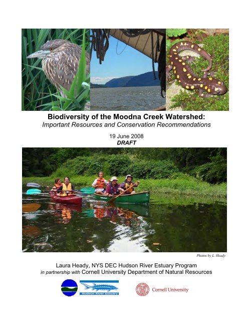
<strong>Biodiversity</strong> <strong>of</strong> <strong>the</strong> <strong>Moodna</strong> <strong>Creek</strong> <strong><strong>Water</strong>shed</strong>:<br />
Important Resources and Conservation Recommendations<br />
19 June 2008<br />
DRAFT<br />
Photos by L. Heady<br />
Laura Heady, NYS DEC Hudson River Estuary Program<br />
in partnership with Cornell University Department <strong>of</strong> Natural Resources
<strong>Moodna</strong> <strong>Biodiversity</strong><br />
L. Heady, 19 June 2008 DRAFT<br />
Acknowledgements<br />
Special thanks to Tom Lake, Chris Bowser, and Leah Abuza <strong>of</strong> <strong>the</strong> NYS DEC Hudson River<br />
Estuary Program for sharing <strong>the</strong>ir observations <strong>of</strong> <strong>the</strong> <strong>Moodna</strong> mouth system and providing<br />
valuable natural history information. Leslie Zucker, also from <strong>the</strong> Hudson River Estuary<br />
Program, contributed <strong>the</strong> “Streams and Riparian Corridors” section and Trout Brook analysis.<br />
Kelly Dobbins <strong>of</strong> <strong>Orange</strong> <strong>County</strong> Planning provided GIS data layers, and Gretchen Stevens and<br />
Bob Schmidt <strong>of</strong> Hudsonia <strong>of</strong>fered assistance with identifying past studies <strong>of</strong> <strong>Moodna</strong><br />
biodiversity. Jamie Deppen <strong>of</strong> Hudsonia helped with checking breeding bird data for <strong>the</strong><br />
watershed.<br />
Prepared by:<br />
Laura Heady<br />
<strong>Biodiversity</strong> Outreach Coordinator<br />
NYS DEC Hudson River Estuary Program<br />
in partnership with Cornell University Department <strong>of</strong> Natural Resources<br />
21 South Putt Corners Road<br />
New Paltz, NY 12561
<strong>Moodna</strong> <strong>Biodiversity</strong><br />
L. Heady, 19 June 2008 DRAFT<br />
Table <strong>of</strong> Contents<br />
Introduction 1<br />
Significance <strong>of</strong> <strong>Biodiversity</strong> to <strong><strong>Water</strong>shed</strong> Planning 1<br />
Threats to <strong>Biodiversity</strong> and Associated Impacts to <strong><strong>Water</strong>shed</strong> Health 1<br />
<strong>Biodiversity</strong> <strong>of</strong> <strong>the</strong> <strong>Moodna</strong> <strong>Creek</strong> <strong><strong>Water</strong>shed</strong> 2<br />
Priority Habitats <strong>of</strong> <strong>the</strong> <strong><strong>Water</strong>shed</strong> 3<br />
How to Use This Information 3<br />
Hudson River Shoreline: The <strong>Moodna</strong> Mouth 4<br />
Lower Reach <strong>of</strong> <strong>Moodna</strong> <strong>Creek</strong> 4<br />
Confluence 4<br />
Marsh and Mudflats 4<br />
Submerged Aquatic Vegetation 7<br />
Threats and Conservation Opportunities 7<br />
Streams and Riparian Corridors 8<br />
Birds 8<br />
Bats 9<br />
Amphibians and Reptiles 9<br />
Fish 9<br />
Threats and Conservation Opportunities 10<br />
Forests 13<br />
Globally Important Forests 13<br />
Regionally Important Forests 14<br />
Locally Important Forests 14<br />
Stepping Stone Forests 14<br />
Threats and Conservation Opportunities 14<br />
Wetlands 15<br />
Rare Wetland Wildlife 15<br />
Wetland Habitat Types 16<br />
Threats and Conservation Opportunities 17<br />
Grasslands, Shrublands, and Farmland 18<br />
Grasslands 18<br />
Shrubland and Early Successional Forest 19<br />
Threats and Conservation Opportunities 19<br />
Cliffs and Caves 20<br />
Habitats and Wildlife <strong>of</strong> Cliffs and Caves 20<br />
Threats and Conservation Opportunities 20<br />
Cores, Connections, and Landscape Perspective 21<br />
Cores 21<br />
Connections 23<br />
Threats and Conservation Opportunities 25<br />
Conclusions 27<br />
Literature Cited 28<br />
Additional Publications on <strong>Biodiversity</strong> in <strong>the</strong> <strong>Moodna</strong> <strong>Creek</strong> <strong><strong>Water</strong>shed</strong> 32
<strong>Moodna</strong> <strong>Biodiversity</strong><br />
L. Heady, 19 June 2008 DRAFT<br />
Figures<br />
Figure 1: Ecological Communities <strong>of</strong> <strong>the</strong> <strong>Moodna</strong> <strong>Creek</strong> Mouth 5<br />
Figure 2: Ecological Communities <strong>of</strong> <strong>the</strong> <strong>Moodna</strong> <strong>Creek</strong> Mouth<br />
and Lower Reach to Firthcliffe Dam 6<br />
Figure 3: Analysis <strong>of</strong> Riparian Buffers Along Trout Brook 11<br />
Figure 4: Documented <strong>Biodiversity</strong> Resources <strong>of</strong> Importance in <strong>the</strong><br />
<strong>Moodna</strong> <strong>Creek</strong> <strong><strong>Water</strong>shed</strong> 22<br />
Figure 5: Conservation Network <strong>of</strong> <strong>Biodiversity</strong> Cores and Connections<br />
in <strong>the</strong> <strong>Moodna</strong> <strong>Creek</strong> <strong><strong>Water</strong>shed</strong> 23<br />
Tables<br />
Table 1. Recommendations for minimum widths and connectivity <strong>of</strong> natural<br />
cover within <strong>the</strong> stream corridor to conserve biodiversity . 12<br />
Appendices<br />
Appendix A. Flagship Species <strong>of</strong> <strong>the</strong> <strong>Moodna</strong> <strong>Creek</strong> <strong><strong>Water</strong>shed</strong><br />
Appendix B. Birds <strong>of</strong> Conservation Concern in <strong>Moodna</strong> <strong>Creek</strong> <strong><strong>Water</strong>shed</strong><br />
Appendix C. Reptiles and Amphibians <strong>of</strong> Conservation Concern in <strong>Moodna</strong> <strong>Creek</strong> <strong><strong>Water</strong>shed</strong>
<strong>Moodna</strong> <strong>Biodiversity</strong><br />
L. Heady, 19 June 2008 DRAFT<br />
Introduction<br />
Significance <strong>of</strong> <strong>Biodiversity</strong> to <strong><strong>Water</strong>shed</strong> Planning<br />
The <strong>Moodna</strong> <strong>Creek</strong> watershed plan provides an ideal opportunity to consider conservation <strong>of</strong><br />
biological resources. The plants, animals, and habitats—or biodiversity—<strong>of</strong> <strong>the</strong> <strong>Moodna</strong><br />
watershed are a significant part <strong>of</strong> <strong>the</strong> region’s character and natural infrastructure, and<br />
contribute directly to <strong>the</strong> quality and quantity <strong>of</strong> drinking water available to residents living in<br />
<strong>the</strong> region.<br />
The term “biodiversity” is used to describe all <strong>the</strong> components <strong>of</strong> nature that are needed to<br />
sustain life. While people <strong>of</strong>ten associate <strong>the</strong> term biodiversity with threatened and endangered<br />
species, it actually encompasses much more. <strong>Biodiversity</strong> refers to all living things, both rare<br />
and common, <strong>the</strong> complex relationships between <strong>the</strong>m, as well as <strong>the</strong>ir relationship to <strong>the</strong><br />
environment. <strong>Biodiversity</strong> includes genetic variety, species diversity, and variability in natural<br />
communities, ecosystems, and landscapes. All <strong>of</strong> <strong>the</strong>se parts and processes comprise <strong>the</strong> web <strong>of</strong><br />
life that contributes to healthy ecosystems.<br />
Why is biodiversity important to <strong>the</strong> people living in <strong>the</strong> <strong>Moodna</strong> <strong>Creek</strong> watershed? For starters,<br />
<strong>the</strong> watershed has a diverse and rich natural heritage, with species and ecological communities <strong>of</strong><br />
regional, statewide, and global significance. These natural systems are <strong>the</strong> scenery and living<br />
fabric that provides <strong>the</strong> <strong>Moodna</strong> <strong>Creek</strong> watershed with a regional identity, and creates a sense <strong>of</strong><br />
place for its residents. And healthy, natural systems are in essence a “green infrastructure,”<br />
supplying services that support life as we know it, through purification <strong>of</strong> drinking water, control<br />
<strong>of</strong> floodwaters, replenishment <strong>of</strong> aquifers, pollination <strong>of</strong> crops, creation <strong>of</strong> fertile soil, control <strong>of</strong><br />
insect pests, and adaptation to a changing climate. They also provide opportunities for hunting<br />
and fishing, outdoor recreation, and environmental education and research. All <strong>of</strong> <strong>the</strong>se services<br />
and benefits to <strong>the</strong> community cost less than <strong>the</strong> artificial or built alternatives, and are widely<br />
recognized as important assets by a variety <strong>of</strong> stakeholders.<br />
Threats to <strong>Biodiversity</strong> and Associated Impacts to <strong><strong>Water</strong>shed</strong> Health<br />
Two <strong>of</strong> <strong>the</strong> greatest threats to biodiversity are habitat loss and invasive species. In particular,<br />
land use changes that degrade and destroy natural habitats pose <strong>the</strong> most significant threats to<br />
native biodiversity. Suburban sprawl, for instance, fragments <strong>the</strong> landscape into smaller and<br />
smaller pieces <strong>of</strong> habitat, and surrounds <strong>the</strong>se fragments with development, <strong>of</strong>ten having lethal<br />
effects on wildlife species that require large, connected natural areas. Fur<strong>the</strong>rmore, <strong>the</strong> resulting<br />
patchwork <strong>of</strong> land uses creates ideal conditions for invasive species to take hold.<br />
Land-use decisions made at <strong>the</strong> municipal and regional level will have lasting impacts on <strong>the</strong><br />
function <strong>of</strong> natural systems in <strong>the</strong> <strong>Moodna</strong> <strong>Creek</strong> watershed, and <strong>the</strong>ir ability to support its<br />
human communities. For example, loss <strong>of</strong> habitat can lead to a corresponding loss in basic<br />
watershed functions, such as water infiltration and purification by forests and grasslands, erosion<br />
control along stream banks, and flood attenuation in wetlands. Habitat loss and fragmentation<br />
also creates unsuitable conditions for many native plants and animals, and leads to increased<br />
populations <strong>of</strong> more common, nuisance species such as white-tailed deer, Canada geese,<br />
mosquitoes, and black-legged tick, which carries Lyme disease.<br />
1
<strong>Moodna</strong> <strong>Biodiversity</strong><br />
L. Heady, 19 June 2008 DRAFT<br />
Additional threats to biodiversity include impacts associated with human development, many <strong>of</strong><br />
which can be reduced or prevented altoge<strong>the</strong>r, such as light pollution, failing septic systems, and<br />
household pets; and pollution <strong>of</strong> natural areas from contaminants such as road salt, pesticides,<br />
fertilizers, and household chemicals and pharmaceuticals. Increasingly, global climate change<br />
presents a new array <strong>of</strong> conservation challenges and variables, such as shifts in habitat<br />
availability and timing <strong>of</strong> natural events.<br />
<strong>Biodiversity</strong> <strong>of</strong> <strong>the</strong> <strong>Moodna</strong> <strong>Creek</strong> <strong><strong>Water</strong>shed</strong><br />
The rich biodiversity <strong>of</strong> <strong>the</strong> <strong>Moodna</strong> <strong>Creek</strong> watershed is a result <strong>of</strong> <strong>the</strong> variable landscape<br />
included within its boundaries. To <strong>the</strong> east and sou<strong>the</strong>ast, <strong>the</strong> watershed includes part <strong>of</strong> <strong>the</strong><br />
Hudson Highlands, where it has its highest point on <strong>the</strong> steep ridges above 1500 ft (500m) in<br />
elevation. This area also contains portions <strong>of</strong> <strong>the</strong> very large forest that continues beyond <strong>the</strong><br />
watershed boundary south to Harriman and Bear Mountain State Parks. The foothills <strong>of</strong> <strong>the</strong><br />
Highlands are scattered throughout <strong>the</strong> sou<strong>the</strong>rn portions <strong>of</strong> <strong>the</strong> watershed, creating steep slopes<br />
and hills interspersed with creeks and wetlands. The <strong>Moodna</strong>/Otterkill corridor runs generally<br />
west-to-east, starting in <strong>the</strong> rich farmland to <strong>the</strong> west, and traversing a fairly broad, forested<br />
floodplain. This corridor forms somewhat <strong>of</strong> a demarcation between <strong>the</strong> more diverse, forested<br />
terrain <strong>of</strong> <strong>the</strong> sou<strong>the</strong>rn half <strong>of</strong> <strong>the</strong> watershed and <strong>the</strong> more rolling topography and farmland to <strong>the</strong><br />
north, which is rich with numerous wetlands. Where <strong>the</strong> <strong>Moodna</strong> finally meets <strong>the</strong> Hudson<br />
River, <strong>the</strong> watershed reaches its lowest elevation at sea level, with <strong>the</strong> tidal influence <strong>of</strong> <strong>the</strong> river<br />
felt in its lower mile.<br />
The biological resources <strong>of</strong> <strong>the</strong> <strong>Moodna</strong> <strong>Creek</strong> watershed have been recognized on many levels<br />
as having high conservation value:<br />
<strong>Moodna</strong> <strong>Creek</strong>, toge<strong>the</strong>r with its tributary <strong>the</strong> Otterkill <strong>Creek</strong>, is identified in <strong>the</strong> <strong>Orange</strong><br />
<strong>County</strong> Open Space Plan as a Priority Aquatic System (June 2004). The Open Space<br />
Plan also identifies several areas within <strong>the</strong> <strong>Moodna</strong> watershed as Biological Diversity<br />
Hotspots, including Goose Pond and Schunemunk mountains and Purgatory Swamp. In<br />
addition, it identifies <strong>the</strong> <strong>Moodna</strong>/Otterkill corridor as a Potential Wildlife Corridor.<br />
In <strong>the</strong> Sou<strong>the</strong>rn Wallkill <strong>Biodiversity</strong> Plan (Miller et al. 2005), <strong>the</strong> Metropolitan<br />
Conservation Alliance (MCA) studied biodiversity in Chester, Goshen, and Warwick.<br />
Areas delineated as important for conservation in <strong>the</strong> <strong>Moodna</strong> watershed included Goose<br />
Pond, Bellvale, Snake, Brimstone, and Sugar Loaf mountains; and <strong>the</strong> Otter Kill, Seely<br />
Brook, and Black Meadow <strong>Creek</strong> corridors. Associated floodplains, wetlands, steep<br />
slopes, and important core and connecting habitats were included in <strong>the</strong> areas mapped as<br />
important for biodiversity.<br />
The Nature Conservancy’s report, Identifying Conservation Priorities in <strong>the</strong> Hudson<br />
River Estuary <strong><strong>Water</strong>shed</strong>, identifies a short list <strong>of</strong> ecoregional aquatic conservation<br />
targets (priority watersheds) within <strong>the</strong> Hudson River Estuary watershed, and <strong>the</strong> <strong>Moodna</strong><br />
<strong>Creek</strong> <strong><strong>Water</strong>shed</strong> is listed as one <strong>of</strong> <strong>the</strong>se priorities (Shirer and Tear 2005).<br />
The Highlands Coalition has designated <strong>the</strong> Schunnemunk Mountain/<strong>Moodna</strong><br />
<strong>Creek</strong>/Woodcock Mountain area as one <strong>of</strong> its Critical Treasure Areas in <strong>the</strong> New York<br />
Highlands, in part due to its biodiversity values (Highlands Coalition 2005).<br />
2
<strong>Moodna</strong> <strong>Biodiversity</strong><br />
L. Heady, 19 June 2008 DRAFT<br />
A sou<strong>the</strong>rn portion <strong>of</strong> <strong>the</strong> <strong>Moodna</strong> watershed is included in <strong>the</strong> “Highlands” Significant<br />
<strong>Biodiversity</strong> Area (SBA) in <strong>the</strong> NYS DEC’s Hudson River Estuary Wildlife and Habitat<br />
Conservation Framework (Penhollow et al. 2006). This SBA recognizes <strong>the</strong> Hudson<br />
Highlands region as important for biodiversity; some features <strong>of</strong> <strong>the</strong> <strong>Moodna</strong> watershed<br />
that are included are Schunnemunk Mountain, Woodcock Hill, Goose Pond Mountain,<br />
Sugarloaf Mountain, Black Rock Forest, Woodbury <strong>Creek</strong>, Satterly <strong>Creek</strong>, Seely Brook,<br />
and Trout Brook.<br />
The <strong>Moodna</strong> <strong>Creek</strong> mouth and tidal wetlands were also included in <strong>the</strong> Framework as<br />
part <strong>of</strong> <strong>the</strong> Hudson River Estuary and Tidal Wetlands SBA. This part <strong>of</strong> <strong>the</strong> watershed,<br />
spanning <strong>the</strong> creek from Orrs Mills to its confluence with <strong>the</strong> Hudson, was designated as<br />
“irreplaceable” Significant Coastal Fish and Wildlife Habitat by <strong>the</strong> NYS Coastal Zone<br />
Management Program, and highlighted as one <strong>of</strong> four Selected Priority <strong><strong>Water</strong>shed</strong>s by<br />
<strong>the</strong> <strong>Orange</strong> <strong>County</strong> Open Space Plan (June 2004).<br />
Priority Habitats <strong>of</strong> <strong>the</strong> <strong><strong>Water</strong>shed</strong><br />
The underlying geology, soils, topography, surface and groundwater, and land use history <strong>of</strong> <strong>the</strong><br />
<strong>Moodna</strong> <strong>Creek</strong> watershed all weave toge<strong>the</strong>r to shape a diversity <strong>of</strong> habitats that support an<br />
equally diverse array <strong>of</strong> plant and animal communities. The priority habitats <strong>of</strong> <strong>the</strong> watershed<br />
include Hudson River shoreline; streams and riparian corridors; forests; a variety <strong>of</strong> wetlands;<br />
grasslands, shrublands, and farms; and cliffs and caves. Appendix A contains a list <strong>of</strong> 17<br />
animals <strong>of</strong> conservation concern, selected as “flagship species” <strong>of</strong> <strong>the</strong> <strong>Moodna</strong> watershed<br />
habitats <strong>the</strong>y use, along with associated planning recommendations, seasonal considerations, and<br />
o<strong>the</strong>r natural history. In many cases, conserving enough habitat to support healthy populations<br />
<strong>of</strong> <strong>the</strong>se flagship species will protect o<strong>the</strong>r plants and animals with similar habitat needs.<br />
Appendix B includes a list <strong>of</strong> birds <strong>of</strong> conservation concern in <strong>the</strong> watershed, and Appendix C<br />
lists amphibians and reptiles <strong>of</strong> conservation concern; both include general habitat information as<br />
well.<br />
How to Use This Information<br />
The following discussion <strong>of</strong> <strong>the</strong>se priority habitats, along with <strong>the</strong> aforementioned appendices,<br />
can be useful not only for watershed planning, but for taking conservation action at <strong>the</strong> municipal<br />
level, as well. While <strong>the</strong> entire watershed has not been studied to locate and map all biological<br />
resources, <strong>the</strong>re is some knowledge <strong>of</strong> where important habitats are, and what plants and animals<br />
<strong>the</strong>y support. It is likely many <strong>of</strong> <strong>the</strong>se same habitats occur elsewhere in <strong>the</strong> watershed, where<br />
underlying conditions are similar. Future assessments can take into consideration what is known<br />
about important habitat occurrences in <strong>the</strong> watershed, to predict and assess <strong>the</strong>ir distribution in<br />
o<strong>the</strong>r unstudied areas, and to proactively plan for <strong>the</strong> associated rare species. Such information<br />
can provide a baseline for habitat maps, natural resource inventories, open space plans, and o<strong>the</strong>r<br />
conservation and smart growth plans. This approach will also contribute to keeping common<br />
species in <strong>the</strong> watershed common, and maintaining overall ecosystem function. Finally, many <strong>of</strong><br />
<strong>the</strong> planning and conservation recommendations discussed below for <strong>the</strong> watershed also apply to<br />
land-use decision making at <strong>the</strong> local level.<br />
3
<strong>Moodna</strong> <strong>Biodiversity</strong><br />
L. Heady, 19 June 2008 DRAFT<br />
Hudson River Shoreline: The <strong>Moodna</strong> Mouth<br />
The confluence <strong>of</strong> <strong>the</strong> <strong>Moodna</strong> <strong>Creek</strong> and Hudson River is especially rich in biodiversity, and<br />
marks <strong>the</strong> average nor<strong>the</strong>rn extent <strong>of</strong> <strong>the</strong> salt front in <strong>the</strong> estuary (although <strong>the</strong> front moves<br />
far<strong>the</strong>r upstream under low flow conditions). The input <strong>of</strong> nutrients from <strong>the</strong> <strong>Moodna</strong> watershed;<br />
<strong>the</strong> mixing <strong>of</strong> <strong>the</strong> <strong>Moodna</strong>’s fresh water with brackish water from <strong>the</strong> Hudson; and <strong>the</strong> tidal<br />
influence <strong>of</strong> <strong>the</strong> estuary toge<strong>the</strong>r create conditions and habitats that are uncommon in New York.<br />
Habitats <strong>of</strong> <strong>the</strong> <strong>Moodna</strong> mouth system include 3.5 miles <strong>of</strong> freshwater tributary, with <strong>the</strong> lower<br />
mile in tidal range <strong>of</strong> <strong>the</strong> Hudson River. Where it reaches <strong>the</strong> river, <strong>the</strong> creek flows into an<br />
approximately 75 acre (30 ha) embayment, with extensive emergent marsh, swamp, mudflats,<br />
submerged aquatic vegetation (SAV), and wooded islands. (See Figure 1.) East <strong>of</strong> <strong>the</strong> railroad<br />
trestle, <strong>the</strong>re are additional mudflats and a large area <strong>of</strong> SAV that continues northward along <strong>the</strong><br />
shoreline. The various habitats and wildlife assembled at <strong>the</strong> <strong>Moodna</strong> mouth <strong>of</strong>fer excellent<br />
opportunities for recreational fishing, birdwatching, paddling, environmental education, and<br />
overall outdoor enjoyment.<br />
Lower Reach <strong>of</strong> <strong>Moodna</strong> <strong>Creek</strong>. Fish habitat in <strong>the</strong> lower portion <strong>of</strong> <strong>Moodna</strong> <strong>Creek</strong> extends<br />
from <strong>the</strong> mouth and upstream for 3.5 miles to <strong>the</strong> dam located just upstream <strong>of</strong> <strong>the</strong> Orrs Mill<br />
bridge on NYS Route 32. (See Figure 2.) Anadromous fish, including alewife and blueback<br />
herring, enter <strong>the</strong> creek in <strong>the</strong> spring for spawning, and <strong>the</strong> resulting larval fish develop in <strong>the</strong><br />
flats at <strong>the</strong> creek mouth. The lower portion <strong>of</strong> <strong>the</strong> <strong>Moodna</strong> also supports a warmwater fish<br />
community throughout <strong>the</strong> year; resident species include American eel, largemouth bass,<br />
smallmouth bass, bluegill, pumpkinseed, white perch, yellow perch, white catfish, and brown<br />
bullhead. As <strong>the</strong> salt front moves up <strong>the</strong> Hudson, bluefish, bay anchovy, weakfish, Atlantic<br />
silversides, hogchoker, and blue crab may enter <strong>the</strong> tributary to feed.<br />
Confluence. The confluence <strong>of</strong> <strong>the</strong> <strong>Moodna</strong> and Hudson provides important habitat for bald<br />
eagle (NYS Threatened) and osprey (NYS Special Concern). Both feed on spawning fish and<br />
waterfowl, and use <strong>the</strong> tall trees along <strong>the</strong> shoreline and on wooded islands for perching and<br />
roosting. The <strong>Moodna</strong> mouth is one <strong>of</strong> <strong>the</strong> few areas in <strong>the</strong> Hudson where eagles are consistently<br />
observed in <strong>the</strong> summer, and <strong>the</strong> area is considered important breeding habitat for bald eagle by<br />
<strong>the</strong> NY Natural Heritage Program. In addition, it supports a wintering population <strong>of</strong> bald eagles<br />
from December through March. (See Appendix A for conservation recommendations for bald<br />
eagle.)<br />
Marsh and Mudflats. The tidal freshwater marsh at <strong>the</strong> mouth <strong>of</strong> <strong>the</strong> <strong>Moodna</strong> is <strong>the</strong> largest in<br />
<strong>Orange</strong> <strong>County</strong>. This 59 acre (24 ha), Class 1 NYS Regulatory Freshwater wetland includes<br />
areas <strong>of</strong> brackish tidal marsh and brackish intertidal mudflats. Statewide, <strong>the</strong>re are few<br />
occurrences <strong>of</strong> <strong>the</strong>se rare ecological communities, which host suites <strong>of</strong> species especially adapted<br />
to <strong>the</strong> changing conditions caused by tides. Due to <strong>the</strong>ir changing salinity values, brackish tidal<br />
marshes provide habitat for a combination <strong>of</strong> species that are characteristic <strong>of</strong> both salt and<br />
freshwater tidal marshes. Brackish intertidal mudflats support populations <strong>of</strong> mobile<br />
invertebrates like clams, snails, worms, and crustaceans that are adapted to <strong>the</strong> unstable surface<br />
<strong>of</strong> <strong>the</strong> mudflat. During high tide, <strong>the</strong>se invertebrates are fed upon by shad, bass, and o<strong>the</strong>r fish;<br />
low tide brings foraging opportunities for shore birds. Rare plants associated with mudflats at<br />
<strong>the</strong> <strong>Moodna</strong> mouth include spongy arrowhead, and historical records <strong>of</strong> estuary beggarticks.<br />
4
Figure 1. Ecological Communities <strong>of</strong> <strong>the</strong> <strong>Moodna</strong> <strong>Creek</strong> Mouth<br />
<strong>Orange</strong> <strong>County</strong>, NY<br />
Legend<br />
NHPCommunities_in_<strong>Moodna</strong><br />
Brackish Intertidal Mudflats<br />
Brackish Tidal Marsh<br />
<strong>Water</strong> Celery SAV Bed<br />
NYS Freshwater Wetland<br />
NWI Palustrine Wetland<br />
NWI Riverine Wetland<br />
NHP Important Habitat Area<br />
<strong>Moodna</strong> <strong><strong>Water</strong>shed</strong> Boundary<br />
Kowawese Unique Area<br />
Railroad<br />
¯<br />
Hudson<br />
River<br />
NEW WINDSOR<br />
<strong>Moodna</strong> <strong>Creek</strong><br />
US9W<br />
CORNWALL<br />
0 0.05 0.1 0.2 0.3 0.4 0.5<br />
Miles<br />
Map created 14 June 2008 by:<br />
Laura Heady, Hudson River Estuary Program,<br />
NYS Department <strong>of</strong> Environmental Conservation<br />
in partnership with Cornell University<br />
Data Sources:<br />
NY Natural Heritage Program<br />
NYS Department <strong>of</strong> Environmental Conservation<br />
National Wetland Inventory
Figure 2. Ecological Communities <strong>of</strong> <strong>the</strong> <strong>Moodna</strong> <strong>Creek</strong> Mouth<br />
and Lower Reach to Firthcliffe Dam <strong>Orange</strong> <strong>County</strong>, NY<br />
Legend<br />
NHPCommunities_in_<strong>Moodna</strong><br />
Brackish Intertidal Mudflats<br />
Brackish Tidal Marsh<br />
<strong>Water</strong> Celery SAV Bed<br />
NYS Freshwater Wetland<br />
NWI Palustrine Wetland<br />
NWI Riverine Wetland<br />
NHP Important Habitat Area<br />
<strong>Moodna</strong> <strong><strong>Water</strong>shed</strong> Boundary<br />
Kowawese Unique Area<br />
Railroads<br />
NEW WINDSOR<br />
US9W<br />
Hudson<br />
River<br />
¯<br />
<strong>Moodna</strong> <strong>Creek</strong><br />
CORNWALL<br />
Firthcliffe Dam<br />
Storm King<br />
0 0.1 0.2 0.4 0.6 0.8 1<br />
Miles<br />
Map created 14 June 2008 by:<br />
Laura Heady, Hudson River Estuary Program,<br />
NYS Department <strong>of</strong> Environmental Conservation<br />
in partnership with Cornell University<br />
Data Sources:<br />
NY Natural Heritage Program<br />
NYS Department <strong>of</strong> Environmental Conservation<br />
National Wetland Inventory
<strong>Moodna</strong> <strong>Biodiversity</strong><br />
L. Heady, 19 June 2008 DRAFT<br />
The wetland complex at <strong>the</strong> <strong>Moodna</strong> mouth provides breeding habitat for a number <strong>of</strong> birds,<br />
including green-backed heron, black duck, wood duck, Virginia rail, spotted sandpiper, fish<br />
crow, and marsh wren, and has been identified as important habitat area for least bittern (NYS<br />
Threatened). (See Appendix A for conservation recommendations for least bittern.) Herons,<br />
waterfowl, and shorebirds concentrate in <strong>the</strong> area during spring and fall migrations, and <strong>the</strong> creek<br />
is thought to be a major crossing point for raptors migrating along <strong>the</strong> nor<strong>the</strong>rn slope <strong>of</strong> <strong>the</strong><br />
Hudson Highlands. In addition, <strong>the</strong> NY Natural Heritage Program considers <strong>the</strong> <strong>Moodna</strong> mouth<br />
an important “<strong>Water</strong>fowl Winter Concentration Area.”<br />
Submerged Aquatic Vegetation. The submerged aquatic vegetation (SAV) beds also contribute<br />
to <strong>the</strong> overall habitat value <strong>of</strong> <strong>the</strong> <strong>Moodna</strong> mouth system. They occur in <strong>the</strong> lower reach <strong>of</strong> <strong>the</strong><br />
creek, in <strong>the</strong> embayment, and east <strong>of</strong> <strong>the</strong> train trestle along <strong>the</strong> Hudson shoreline. (See Figure 2.)<br />
Unlike o<strong>the</strong>r tidal coves and bays in <strong>the</strong> Hudson where <strong>the</strong> invasive water chestnut <strong>of</strong>ten<br />
dominates and poses management challenges, <strong>the</strong> SAV beds at <strong>the</strong> <strong>Moodna</strong> mouth are comprised<br />
<strong>of</strong> water celery, a native plant. SAV beds trap fine sediment and organic matter, maintain<br />
dissolved oxygen levels, and provide habitat for a rich diversity <strong>of</strong> fish and invertebrates<br />
(Findlay et al. 2006).<br />
Threats and Conservation Opportunities<br />
• <strong>Water</strong> quality. Habitat value for fish and wildlife in <strong>the</strong> lower reach <strong>of</strong> <strong>the</strong> creek, and<br />
associated recreation opportunities, is dependent on good water quality. Herring may<br />
already be an indicator <strong>of</strong> declining conditions in <strong>the</strong> <strong>Moodna</strong>. In 1996, Hudsonia<br />
reported a moderately large herring run on <strong>the</strong> <strong>Moodna</strong> (Schmidt and Cooper 1996).<br />
Local fishermen have observed declines in this run in <strong>the</strong> last six years, and speculate that<br />
this decrease coincides with sewage problems in <strong>the</strong> <strong>Moodna</strong> (L. Abuza, pers. comm.).<br />
The NYS DEC Hudson River Fisheries Unit selected <strong>the</strong> <strong>Moodna</strong> for <strong>the</strong> 2008 Volunteer<br />
River Herring Monitoring Survey due to its historically large herring run. Over 35<br />
monitoring sessions in April and May found no evidence <strong>of</strong> river herring in <strong>the</strong> <strong>Moodna</strong>,<br />
while <strong>the</strong> same protocols were used successfully to document herring in o<strong>the</strong>r monitored<br />
streams in <strong>the</strong> estuary watershed. To address water quality concerns, <strong>the</strong> two sewage<br />
treatment plants in <strong>the</strong> vicinity <strong>of</strong> <strong>the</strong> <strong>Moodna</strong> mouth should be assessed to understand<br />
and avoid impacts to <strong>the</strong> rich biodiversity <strong>of</strong> <strong>the</strong> area. Riparian buffers should be<br />
maintained and restored as necessary, and pollution from stormwater run<strong>of</strong>f should be<br />
prevented.<br />
• Marsh and mudflats. The large marsh and mudflat habitat complex may also be<br />
vulnerable to pollution from <strong>the</strong> nearby sewage treatment plants, and to dumping,<br />
channeling, and disturbing remaining upland buffers. An additional threat is invasion <strong>of</strong><br />
exotic species such as purple loosestrife and water chestnut. Recreational boat traffic that<br />
scrapes mudflats at high tides degrades <strong>the</strong>ir important habitat value and should be<br />
prevented. Hardened shorelines should be minimized or avoided and instead, low-sloped<br />
shorelines should be maintained within <strong>the</strong> tidal zone. This will be especially important<br />
as climate change causes sea level rise, and tidal habitats need to migrate inland.<br />
• SAV beds. SAV beds are especially vulnerable to motorized boating activity and<br />
shoreline access; recreational activity should be limited in areas <strong>of</strong> SAV. Maintaining<br />
natural shorelines is strongly encouraged.<br />
• Breeding marsh birds. Disturbance <strong>of</strong> breeding birds can result in failed nesting efforts<br />
or abandonment <strong>of</strong> nests completely. Marsh bird communities have shown significant<br />
7
<strong>Moodna</strong> <strong>Biodiversity</strong><br />
L. Heady, 19 June 2008 DRAFT<br />
decline when urban/suburban development within 1600 ft (500 m) and 3200 ft (1000 m)<br />
<strong>of</strong> <strong>the</strong> marsh exceeds 14% and 25%, respectively (DeLuca et al., as cited in McElfish et<br />
al. 2008). Such impacts can be reduced by maintaining and restoring effective buffers,<br />
and by educating visitors and landowners about marsh bird ecology. (See Appendix A.)<br />
• Citizen science. Pursuit <strong>of</strong> opportunities to engage local residents in citizen science and<br />
conservation <strong>of</strong> <strong>the</strong> <strong>Moodna</strong> mouth system is encouraged. Partnerships with <strong>the</strong> Hudson<br />
River Estuary Program can be formed to engage high school students in eel monitoring,<br />
provide continuing volunteer opportunities for herring monitoring in <strong>the</strong> tidal creek, and<br />
plan riparian buffer restoration through Trees for Tribs.<br />
• Public outreach. Exploration <strong>of</strong> <strong>the</strong> Hudson shoreline and tidal creek through public<br />
canoe and kayak programs is recommended to help connect watershed residents to <strong>the</strong>ir<br />
rich local resources.<br />
Streams and Riparian Corridors<br />
Written by Leslie Zucker, NYS DEC Hudson River Estuary Program and Cornell University<br />
Streams and <strong>the</strong> vegetated corridors around <strong>the</strong>m (called “riparian areas”) make a critical<br />
contribution to <strong>the</strong> health and overall biodiversity <strong>of</strong> <strong>the</strong> <strong>Moodna</strong> <strong>Creek</strong> <strong><strong>Water</strong>shed</strong>. Plants and<br />
animals create <strong>the</strong> environmental conditions necessary for many <strong>of</strong> <strong>the</strong> water quality and<br />
hydrologic functions <strong>of</strong> streams. Plants allow groundwater to infiltrate <strong>the</strong> soil and recharge<br />
aquifers, streams, and reservoirs. Plants hold soils in place and contribute to processes that filter<br />
contaminants and excess nutrients from run<strong>of</strong>f. Vegetated, low-lying areas near streams absorb<br />
storm waters and lessen flooding and erosion downstream. Ultimately, <strong>the</strong>se benefits save local<br />
governments money and protect private property.<br />
Riparian areas are also unique habitats that support a high abundance and diversity <strong>of</strong> plants and<br />
animals. Because <strong>the</strong>y are transition zones between <strong>the</strong> wet, aquatic environment <strong>of</strong> <strong>the</strong> stream<br />
channel, and <strong>the</strong> drier and higher terrestrial uplands, <strong>the</strong>y are highly biodiverse. Some aquatic<br />
and semi-aquatic animals that must be near water, are found only in riparian corridors, while<br />
o<strong>the</strong>r wildlife are found in greater abundance in riparian corridors. Stream corridors contain o<strong>the</strong>r<br />
unique habitat features. When flooded during high flows, riparian corridors become stream<br />
channel habitat and are used as refuges for larval fish. Riparian areas <strong>of</strong>ten contain wetlands that<br />
provide habitat for <strong>the</strong> Hudson Valley’s globally important amphibian and reptile diversity. And,<br />
streams corridors are used by wildlife as transportation routes if suitable habitats remain<br />
connected across <strong>the</strong> landscape.<br />
Some <strong>of</strong> <strong>the</strong> unique fish and wildlife <strong>of</strong> <strong>the</strong> <strong>Moodna</strong> <strong>Creek</strong> and its tributaries are described<br />
below.<br />
Birds<br />
A variety <strong>of</strong> songbirds can be found nesting and rearing <strong>the</strong>ir young in wide, forested<br />
bottomlands <strong>of</strong> <strong>the</strong> <strong>Moodna</strong> <strong>Creek</strong>, including a few that prefer to nest near streams such as <strong>the</strong><br />
yellow-throated vireo, warbling vireo, and Louisiana waterthrush. The cerulean warbler and least<br />
flycatcher are likely stream corridor birds that have declined throughout <strong>the</strong>ir ranges in recent<br />
decades, but are still found in <strong>the</strong> <strong>Moodna</strong> <strong>Creek</strong> <strong><strong>Water</strong>shed</strong>. O<strong>the</strong>r birds that might be seen in<br />
stream corridors <strong>of</strong> <strong>the</strong> watershed include <strong>the</strong> wood duck, great blue heron, green heron, belted<br />
kingfisher, and in <strong>the</strong> deeper forests, <strong>the</strong> red-shouldered hawk. Birds are found more abundantly<br />
8
<strong>Moodna</strong> <strong>Biodiversity</strong><br />
L. Heady, 19 June 2008 DRAFT<br />
in stream corridors than in o<strong>the</strong>r portions <strong>of</strong> <strong>the</strong> landscape and bird diversity increases as <strong>the</strong><br />
width <strong>of</strong> stream corridors increase.<br />
Bats<br />
An abundance <strong>of</strong> insects and forest openings make stream corridors prime foraging habitat for<br />
bats. Large trees with peeling bark, such as shagbark hickories and dead standing snags are used<br />
as maternity colonies or summer roosting sites for bats. In addition to foraging and roosting, bats<br />
use stream corridors as travel routes. Bats that might be seen in stream corridors <strong>of</strong> <strong>the</strong> <strong>Moodna</strong><br />
<strong>Creek</strong> and tributaries include <strong>the</strong> big brown bat, little brown bat, and <strong>the</strong> rare Eastern smallfooted<br />
bat (NYS Special Concern). The Eastern small-footed bat has been observed in <strong>the</strong><br />
Mineral Spring Brook and Trout Brook stream corridors. The watershed and its stream corridors<br />
are also home to <strong>the</strong> federally endangered Indiana bat (NYS Endangered).<br />
Amphibians and Reptiles<br />
Several turtle, frog, and salamander species rely heavily on stream corridor habitats. The wood<br />
turtle is particularly interesting, not just because its angular shell looks like a wood carving, but<br />
also because <strong>the</strong> wood turtle spends its entire life in stream corridors. Wood turtle populations<br />
are found in stream corridors <strong>of</strong> <strong>the</strong> Otter Kill, Seely Brook and Woodbury <strong>Creek</strong>.<br />
Stream salamanders are lungless and must obtain oxygen through <strong>the</strong>ir skin. As a result, <strong>the</strong>y can<br />
be found in <strong>the</strong> moist areas <strong>of</strong> streambanks, seepages, and both intermittent and perennial<br />
streams. The most abundant headwater stream salamander in <strong>the</strong> Hudson Valley region is <strong>the</strong><br />
nor<strong>the</strong>rn two-lined salamander followed by <strong>the</strong> nor<strong>the</strong>rn dusky salamander. The longtail<br />
salamander is rare in <strong>Orange</strong> <strong>County</strong> and declining within New York State.<br />
Fish<br />
Fish communities <strong>of</strong> <strong>the</strong> <strong>Moodna</strong> <strong>Creek</strong> range from anadramous fishes that use <strong>the</strong> tidal creek<br />
and mouth for spawning, to inland warmwater and coldwater fish communities. Little<br />
comprehensive monitoring <strong>of</strong> <strong>the</strong> <strong>Moodna</strong> <strong>Creek</strong> fish community has been conducted. The<br />
historical warmwater fish community includes <strong>the</strong> following species: white sucker, creek<br />
chubsucker, rock bass, redbreast sunfish, pumpkinseed, black crappie, blueback shad, American<br />
shad, cutlips minnow, Eastern silvery minnow, golden shiner, bridle shiner, common shiner,<br />
spotfin shiner, spottail shiner, fallfish, longnose dace, blacknose dace, creek chub, redfin<br />
pickerel, chain pickerel, brown bullhead, fourspine stickleback, and tessellated darter (NYS<br />
Museum 1936). Of <strong>the</strong>se, <strong>the</strong> creek chubsucker, Eastern silvery minnow, bridle shiner, spottail<br />
shiner, spotfin shiner, fallfish, and fourspine stickleback have not been observed in recent times<br />
(NYSDEC Bureau <strong>of</strong> Fisheries 2007). However, additional surveys would be needed to confirm<br />
<strong>the</strong> presence or absence <strong>of</strong> <strong>the</strong>se species.<br />
Coldwater fishes <strong>of</strong> <strong>the</strong> <strong>Moodna</strong> <strong>Creek</strong> <strong><strong>Water</strong>shed</strong> include <strong>the</strong> native brook trout, and <strong>the</strong> stocked<br />
rainbow trout and brown trout. Stream reaches supporting coldwater fishes, invertebrates, and<br />
salamanders are usually fed by cold-cool groundwater. Brook trout and slimy sculpin are <strong>the</strong><br />
dominate fish <strong>of</strong> small coldwater streams <strong>of</strong> high quality. These streams have shallow margins,<br />
woody debris, canopy shading, and boulders. Blacknose dace, creek chub, and white sucker<br />
might also occur at coldwater sites. Both brook and brown trout are found in <strong>the</strong> Trout Brook and<br />
Woodbury <strong>Creek</strong> tributaries. The DEC annually stocks <strong>the</strong> <strong>Moodna</strong> <strong>Creek</strong> mainstem with brown<br />
and rainbow trout and <strong>the</strong> Woodbury <strong>Creek</strong> with brown trout.<br />
9
<strong>Moodna</strong> <strong>Biodiversity</strong><br />
L. Heady, 19 June 2008 DRAFT<br />
Little is known about changes in <strong>the</strong> abundance <strong>of</strong> fish within <strong>the</strong> watershed. Parts <strong>of</strong> <strong>the</strong><br />
watershed could still retain near historical levels <strong>of</strong> fish diversity, if not abundance. However,<br />
o<strong>the</strong>r major tributaries <strong>of</strong> <strong>the</strong> Hudson River have experienced declines in fish diversity and shifts<br />
in abundance between <strong>the</strong> 1930s and <strong>the</strong> 1990s related to changing land uses and pollution, and<br />
it’s likely parts <strong>of</strong> <strong>the</strong> <strong>Moodna</strong> <strong>Creek</strong> system have as well (Stainbrook et al. 2006, Daniels 1999).<br />
Threats and Conservation Opportunities<br />
• Stream fragmentation. One <strong>of</strong> greatest threats to stream corridor biodiversity is <strong>the</strong><br />
modification and fragmentation <strong>of</strong> stream corridors. Fragmentation occurs through direct<br />
modification <strong>of</strong> <strong>the</strong> stream channel and clearing for incompatible land uses within <strong>the</strong><br />
stream corridor. A first step to <strong>the</strong> conservation <strong>of</strong> existing riparian corridors is to map<br />
riparian cover from <strong>the</strong> edge <strong>of</strong> <strong>the</strong> bankfull channel, to as far inland as natural vegetation<br />
extends. These areas can <strong>the</strong>n be reviewed for <strong>the</strong>ir biological significance and level <strong>of</strong><br />
connectivity, given <strong>the</strong> surrounding land uses. (See Figure 3 for an example <strong>of</strong> how<br />
buffer width analysis can be used to identify conservation and restoration opportunities.)<br />
Approaches that have been used to protect existing buffers include: fee simple<br />
acquisition, conservation easements, municipal planning tools, riparian buffer ordinances,<br />
and development tools (Alliance for <strong>the</strong> Chesapeake Bay 2004).<br />
• Riparian buffers. Riparian buffer plantings are recommended for stream reaches with<br />
breaks in continuous natural cover. To enhance connectivity, stream corridor<br />
conservation programs should seek to maintain existing natural cover along both banks <strong>of</strong><br />
<strong>the</strong> stream and extending as far into adjacent areas as needed to maintain stream integrity<br />
(see Table 1 for width recommendations). It is important to protect riparian areas along<br />
both stream banks for both habitat and channel stability. Most streams in settled areas<br />
have variable-width buffers that can accommodate both land uses and conservation goals.<br />
Generally, headwater streams (first to third order) require smaller buffer widths to<br />
maintain stream integrity, while mid-order reaches require <strong>the</strong> widest buffers. Midreaches<br />
are usually highest in biological diversity (although headwater streams are key to<br />
overall stream health) and most prone to channel erosion.<br />
• Comprehensive conservation and management. It is possible, and recommended to<br />
combine conservation <strong>of</strong> stream corridor habitats with o<strong>the</strong>r stream management<br />
priorities. For example, <strong>the</strong> mapped 500-year floodplain viewed along with mapped<br />
stream corridor habitats could be used to identify conservation zones that meet both<br />
habitat and floodplain management objectives.<br />
• Climate change adaptation. As precipitation patterns change due to global climate<br />
change, more high flow events are likely to occur, putting infrastructure near streams at<br />
risk (NECIA 2006). Shifts in streamflow have <strong>the</strong> ability to create new patterns <strong>of</strong><br />
erosion and deposition in channels (see Rosgen 1994). Conserving wide, connected<br />
stream corridors is an important climate change adaptation strategy that will help to<br />
maintain biodiversity and protect vulnerable infrastructure, water supplies and water<br />
quality.<br />
• Stream microhabitats. High quality in-stream habitat usually requires a patchwork <strong>of</strong><br />
riffles and pools, and <strong>the</strong> input <strong>of</strong> woody debris to maximize habitat structure and create<br />
sufficient oxygen levels for aquatic life. Where possible, woody vegetation (shrubland<br />
and forests) should be allowed to mature, or restored through forest buffer plantings.<br />
10
Figure 3. Analysis <strong>of</strong> Riparian Buffers<br />
Along Trout Brook<br />
Trout Brook flows nearly 6 miles from its<br />
headwaters in <strong>the</strong> Towns <strong>of</strong> Warwick and<br />
Monroe through <strong>the</strong> Town <strong>of</strong> Chester where it<br />
merges with Seely Brook. The Trout Brook<br />
watershed forms a corridor between <strong>the</strong><br />
Sterling Forest State Park in <strong>the</strong> far sou<strong>the</strong>rn<br />
portion <strong>of</strong> <strong>the</strong> watershed and Goose Pond State<br />
Park to <strong>the</strong> north. Most <strong>of</strong> Trout Brook is a<br />
coldwater stream classified as trout waters by<br />
<strong>the</strong> NYSDEC and is suitable for primary and<br />
secondary contact recreation. Fish surveys<br />
conducted by DEC near Lakes Road in 2000<br />
found blacknose dace, brook trout, brown<br />
trout, pumpkinseed, and white sucker. The<br />
Trout Brook watershed is heavily forested and<br />
primarily developed for residential land use<br />
near <strong>the</strong> stream. The uplands are a complex <strong>of</strong><br />
large Appalachian oak-hickory and Chestnut<br />
oak forests and wetlands.<br />
An analysis <strong>of</strong> buffer widths along Trout<br />
Brook reveals opportunities for conservation <strong>of</strong><br />
existing wide forest buffers that connect <strong>the</strong><br />
stream with forested uplands. Stream reaches<br />
shown in bright green in <strong>the</strong> illustration at left<br />
have forest buffers over 500’ in width. These<br />
reaches are likely to have high biological<br />
diversity. Sections shown in darker green are<br />
bordered by forests <strong>of</strong> at least 300’ in width on<br />
one or both sides <strong>of</strong> <strong>the</strong> stream. Buffers <strong>of</strong> this<br />
width support stream integrity and provide<br />
habitat for breeding birds, wood turtles, and<br />
stream salamander populations. Opportunities<br />
for rehabilitation in <strong>the</strong>se reaches should be<br />
fur<strong>the</strong>r investigated. Sections shown in bright<br />
pink have buffers <strong>of</strong> 100’ or less on one or<br />
both sides <strong>of</strong> <strong>the</strong> stream. Along <strong>the</strong>se reaches,<br />
<strong>the</strong>re are opportunities for landowners to<br />
engage in riparian buffer plantings and o<strong>the</strong>r<br />
management improvements. A nearly<br />
continuous forest buffer <strong>of</strong> 35’-100’ in width is<br />
necessary to provide shading and protect<br />
coldwater habitat for trout.<br />
Analysis by Leslie Zucker, NYS Department <strong>of</strong> Environmental Conservation in partnership with<br />
Cornell University. Map created May 23, 2008.
<strong>Moodna</strong> <strong>Biodiversity</strong><br />
L. Heady, 19 June 2008 DRAFT<br />
• <strong><strong>Water</strong>shed</strong> land use. Ano<strong>the</strong>r significant threat to stream integrity is watershed land use<br />
that alters <strong>the</strong> flow patterns <strong>of</strong> water. A number <strong>of</strong> studies have observed a “threshold<br />
effect” where urban land cover over 10% <strong>of</strong> <strong>the</strong> watershed area coincides with<br />
degradation in stream fish and macroinvertebrate communities (Schuler 1994. This<br />
threshold has been observed in <strong>the</strong> <strong>Moodna</strong> <strong>Creek</strong> for both anadromous and resident<br />
fishes (Limburg and Schmidt 2001). The impacts <strong>of</strong> urbanization can be reduced by<br />
limiting sprawl, implementing stormwater control practices, and situating development<br />
outside <strong>of</strong> stream corridors. Urban development and land modification within <strong>the</strong> stream<br />
corridor is particularly harmful. These actions create local stress for a system that may<br />
already be impaired by overall watershed development. The alternative is for landowners<br />
and municipalities to engage in programs that protect or restore natural conditions near<br />
<strong>the</strong> stream.<br />
• Fur<strong>the</strong>r study. Little is known about <strong>the</strong> status <strong>of</strong> fish and o<strong>the</strong>r aquatic communities in<br />
<strong>the</strong> <strong>Moodna</strong> <strong>Creek</strong> and its tributaries. Partnerships to complete biological surveys and<br />
develop monitoring protocols should be explored with a range <strong>of</strong> actors such as <strong>the</strong><br />
NYSDEC, county and local agencies, and area research and conservation organizations.<br />
At <strong>the</strong> same time, an assessment <strong>of</strong> stream habitat and physical condition should be<br />
conducted to determine if habitat alteration is a significant threat to stream integrity in <strong>the</strong><br />
<strong>Moodna</strong> watershed.<br />
Table 1. Recommendations for minimum widths and connectivity <strong>of</strong> natural cover within <strong>the</strong> stream<br />
corridor to conserve biodiversity. Table created by L. Zucker.<br />
Wildlife Species<br />
or Group<br />
Minimum<br />
Buffer Width<br />
Wood Turtle 300-1,000’ 1 mile<br />
Stream<br />
Salamanders<br />
Minimum<br />
Stream Length<br />
Sources<br />
NYSDEC Endangered Species<br />
Program; NY Natural Heritage<br />
Program; Compton et al. 2002<br />
150’ Continuous Simlitsch and Bodie 2003<br />
Bats 300’-500’ Continuous<br />
Birds<br />
Warmwater<br />
fishes<br />
Minimum 100’ for<br />
edge and resident<br />
birds<br />
Minimum 300-500’<br />
for migratory and<br />
forest interior birds<br />
150’<br />
Coldwater fishes 35’-100’<br />
Continuous<br />
Limit breaks in<br />
cover and reduce <strong>the</strong><br />
direct hydraulic<br />
connection <strong>of</strong><br />
surface water and<br />
storm sewers to <strong>the</strong><br />
stream<br />
80% <strong>of</strong> banks with<br />
at least 35’ forest<br />
cover<br />
NY Natural Heritage Program;<br />
Menzel et al. 2005<br />
Spackman and Hughes 1995;<br />
Stauffer and Best 1980<br />
Wang et al. 2001<br />
Wenger et al. 1999<br />
12
<strong>Moodna</strong> <strong>Biodiversity</strong><br />
L. Heady, 19 June 2008 DRAFT<br />
Forests<br />
While much <strong>of</strong> <strong>the</strong> forested land in <strong>the</strong> <strong>Moodna</strong> <strong>Creek</strong> watershed is fragmented, <strong>the</strong>re remain<br />
significant forest resources, ranging from large, matrix forests <strong>of</strong> global importance to smaller,<br />
stepping stone forests which provide important links to core habitat areas. These forest<br />
ecosystems, located primarily in <strong>the</strong> eastern and sou<strong>the</strong>rn portions <strong>of</strong> <strong>the</strong> watershed, are<br />
extremely important to biodiversity, but also <strong>of</strong>fer essential services to <strong>the</strong> human community.<br />
Forests, particularly large stands, contribute to water quality and quantity, mitigate effects <strong>of</strong><br />
climate change, produce timber, and provide recreational opportunities such as hiking, hunting,<br />
and birdwatching.<br />
The <strong>Orange</strong> <strong>County</strong> Open Space Plan (2004) provides a good overview <strong>of</strong> forest resources for<br />
<strong>the</strong> entire county; <strong>the</strong> following discussion <strong>of</strong> <strong>the</strong> <strong>Moodna</strong> watershed reflects <strong>the</strong> size classes<br />
described in <strong>the</strong> Open Space Plan.<br />
Globally Important Forests (greater than 15,000 acres). The Nature Conservancy’s<br />
“ecoregional planning” efforts identified “matrix” community types that extend over very large<br />
areas <strong>of</strong> 1,000 to many millions <strong>of</strong> acres, <strong>of</strong>ten covering 80% or more <strong>of</strong> <strong>the</strong> undeveloped<br />
landscape. The size and natural condition <strong>of</strong> <strong>the</strong> identified “matrix forests” allow for <strong>the</strong><br />
maintenance <strong>of</strong> dynamic ecological processes and meet <strong>the</strong> breeding requirements <strong>of</strong> species<br />
associated with forest interior conditions. The <strong>Moodna</strong> watershed contains two such globallyimportant,<br />
matrix forests. The east side <strong>of</strong> <strong>the</strong> watershed contains a large portion <strong>of</strong> <strong>the</strong> West<br />
Point/Black Rock matrix forest, which in total includes over 20,000 acres (8,100 ha) <strong>of</strong> core<br />
habitat, and connects southward to <strong>the</strong> even larger Harriman matrix forest. Protected lands in<br />
this forest include Storm King State Park, Black Rock Forest, and West Point Military Academy<br />
(although <strong>the</strong> latter is not permanently protected). The watershed’s sou<strong>the</strong>rn tip in Monroe enters<br />
<strong>the</strong> Ringwood matrix forest, which in total includes an expanse <strong>of</strong> over 50,000 core acres (20,000<br />
ha) and includes protected lands in Sterling State Forest. Forests <strong>of</strong> this size are large enough so<br />
over time <strong>the</strong>y will express a range <strong>of</strong> forest successional stages including areas that have been<br />
subjected to recent large-scale disturbance such as blowdowns and fire, areas under recovery,<br />
and mature areas. These forests also provide sufficient area to support enough individuals <strong>of</strong><br />
most species to maintain genetic diversity over several generations. (<strong>Orange</strong> <strong>County</strong> Open Space<br />
Plan 2004)<br />
The large forests <strong>of</strong> <strong>the</strong> Hudson Highlands are primarily Appalachian oak-hickory forest,<br />
chestnut oak forest, and oak-tulip forest, and are interspersed with smaller but ecologically<br />
significant patch communities, such as pitch pine-oak-heath rocky summit, rocky summit<br />
grassland, and woodland pools. These large, relatively undeveloped blocks <strong>of</strong> forests, wetlands,<br />
grasslands, and ridges are noteworthy for <strong>the</strong> links <strong>the</strong>y provide between <strong>the</strong> mid-Atlantic states<br />
and New England, and for <strong>the</strong> wildlife species <strong>the</strong>y support, which are wide-ranging and areasensitive,<br />
and thrive in large, unfragmented landscapes. Examples <strong>of</strong> wildlife using large forest<br />
habitat in <strong>the</strong> <strong>Moodna</strong> watershed include black bear and bobcat; Indiana bat; timber rattlesnake<br />
and wood turtle; and many birds, including warblers and thrushes.<br />
Regionally Important Forests (14,999 down to 6, 000 acres). The <strong>Orange</strong> <strong>County</strong> Open Space<br />
Plan highlights forest patches greater than 6,000 acres (2,400 ha) as important for habitat to more<br />
area-sensitive species, and because <strong>the</strong>y can accommodate <strong>the</strong> large-scale disturbances that<br />
maintain forest health over time. The plan identifies a regionally important forest on and around<br />
13
<strong>Moodna</strong> <strong>Biodiversity</strong><br />
L. Heady, 19 June 2008 DRAFT<br />
Schunnemunk Mountain. This forest is primarily chestnut oak forest, but at higher elevations,<br />
includes one <strong>of</strong> <strong>the</strong> best statewide examples <strong>of</strong> pitch pine-oak-heath rocky summit community.<br />
In <strong>the</strong> stream drainages, <strong>the</strong> chestnut oak forest is replaced by hemlock-nor<strong>the</strong>rn hardwood<br />
forest, most <strong>of</strong> which has been killed <strong>of</strong>f by wooly adelgid.<br />
Locally Important Forests (5,999 down to 2,000 acres). These small but locally important<br />
forests <strong>of</strong>ten represent <strong>the</strong> lower limit <strong>of</strong> intact, viable forest size for forest-dependent birds,<br />
which <strong>of</strong>ten require 2,500 to 7,500 acres (1,000 to 3,000 ha) <strong>of</strong> intact interior habitat. These<br />
forests, like <strong>the</strong> larger regionally important forests, also provide important corridors and<br />
connectivity among forest ecosystems within <strong>Orange</strong> <strong>County</strong>. The Open Space Plan indicates<br />
that in <strong>the</strong> <strong>Moodna</strong> watershed, <strong>the</strong>re are a only a few locally important forests remaining. These<br />
are found in Goose Pond Mountain State Park in Chester, near <strong>the</strong> headwaters <strong>of</strong> Trout Brook,<br />
and straddling <strong>the</strong> borders <strong>of</strong> Hamptonburgh and Goshen along <strong>the</strong> Otter Kill.<br />
Stepping Stone Forests (1,999 down to 200 acres). These smaller forests provide valuable,<br />
relatively broad corridors and links to larger patches <strong>of</strong> habitat such as <strong>the</strong> local, regional, and<br />
global forests found in <strong>the</strong> watershed. Such broad connections are more effective than narrow,<br />
linear corridors, and enable species to move from one habitat to ano<strong>the</strong>r across an o<strong>the</strong>rwise<br />
hostile and fragmented landscape. There are a number <strong>of</strong> stepping stone forests in <strong>the</strong> <strong>Moodna</strong><br />
watershed, including patches to <strong>the</strong> west <strong>of</strong> Schunnemunk; to <strong>the</strong> west and south <strong>of</strong> Goose Pond;<br />
and to <strong>the</strong> south <strong>of</strong> Stewart State Forest.<br />
Threats and Conservation Opportunities<br />
• Setting priorities for forest conservation. Smaller blocks <strong>of</strong> forests are less likely to<br />
support <strong>the</strong> rich diversity <strong>of</strong> species <strong>of</strong> <strong>the</strong> <strong>Moodna</strong> <strong>Creek</strong> watershed. The <strong>Orange</strong><br />
<strong>County</strong> Open Space Plan suggests that priorities for protection <strong>the</strong>refore should range<br />
from high to low as forest blocks range from globally important (high priority) to<br />
stepping stone (lowest priority).<br />
• Protection <strong>of</strong> large forests. Globally-important forests are increasingly rare in <strong>the</strong><br />
Hudson Valley, where development patterns have fragmented most forested lands into<br />
smaller and smaller patches. Communities in <strong>the</strong> <strong>Moodna</strong> watershed have an important<br />
stewardship role to play in <strong>the</strong> conservation <strong>of</strong> large, contiguous forests, and where<br />
possible, expanding on <strong>the</strong>m by protecting adjacent forested lands through acquisition,<br />
conservation easement, sustainable forestry agreements, and effective conservation<br />
subdivision design. The forest blocks identified in <strong>the</strong> <strong>Orange</strong> <strong>County</strong> Open Space Plan<br />
should serve as a framework for establishing priorities and opportunities to maintain<br />
habitat connectivity between large core areas such as Schunnemunk Mountain and Storm<br />
King, or Goose Pond and Sterling Forest. (See “Cores, Connections, and Landscape<br />
Perspective” section.)<br />
• Forest fragmentation. Fur<strong>the</strong>r fragmentation <strong>of</strong> forest patches should be prevented.<br />
Placement <strong>of</strong> future roads, driveways, utility lines, and o<strong>the</strong>r fragmenting features should<br />
be designed to avoid intact, contiguous forested areas. Such fragmentation leads to<br />
decreased habitat availability, introduction <strong>of</strong> invasive species like Japanese barberry,<br />
increased songbird nest predation and parasitism, and increased mortality <strong>of</strong> wildlife<br />
attempting to cross roads and developed areas. There are human health implications as<br />
well. Research conducted in Dutchess <strong>County</strong> suggested a link between increased risk <strong>of</strong><br />
Lyme disease and reduced forest size, due to an associated reduction in small mammal<br />
14
<strong>Moodna</strong> <strong>Biodiversity</strong><br />
L. Heady, 19 June 2008 DRAFT<br />
diversity. The prevalence <strong>of</strong> white-footed mice in small, isolated forest patches led to<br />
higher incidence <strong>of</strong> Lyme, since this mouse is <strong>the</strong> most effective carrier <strong>of</strong> <strong>the</strong> bacterium<br />
that causes <strong>the</strong> disease. The risk <strong>of</strong> Lyme disease is much lower in intact forest<br />
ecosystems where <strong>the</strong> infection rate is diluted by a diverse small mammal fauna (Allan et<br />
al. 2003).<br />
• Forest habitat for pool-breeding amphibians. Planning for future development and<br />
timber harvesting should include practices to conserve adequate forested habitat around<br />
woodland pools to support forest amphibians (see “Wetlands” section). Pool-breeding<br />
species such as marbled salamander, Jefferson salamander, and wood frog require<br />
substantial forested areas for all non-breeding parts <strong>of</strong> <strong>the</strong>ir life cycle. Recommendations<br />
in Calhoun and Klemens (2002) and Calhoun and deMaynadier (2004) should be<br />
followed.<br />
• Natural disturbance. Forest systems benefit from cycles <strong>of</strong> natural disturbance. A<br />
history <strong>of</strong> fire suppression in <strong>the</strong> larger forests <strong>of</strong> <strong>the</strong> watershed has contributed to<br />
changes in forest community structure, and build-up <strong>of</strong> fuel material. The expansive<br />
wildfire at Minnewaska State Park Preserve in Ulster <strong>County</strong> in spring 2008 illustrates<br />
how fire suppression can ultimately lead to more intense and difficult to manage<br />
wildfires. Prescribed burning may provide a favorable alternative for <strong>the</strong> large forests in<br />
<strong>the</strong> <strong>Moodna</strong> watershed, and warrants investigation.<br />
Wetlands<br />
The <strong>Moodna</strong> <strong>Creek</strong> watershed contains a diversity <strong>of</strong> wetland habitats…from <strong>the</strong> freshwater tidal<br />
marsh at <strong>the</strong> creek mouth to <strong>the</strong> small woodland pools in Black Rock Forest, to <strong>the</strong> large<br />
hardwood swamps in <strong>the</strong> Otter Kill basins, and <strong>the</strong> fens and freshwater marshes in <strong>the</strong> Black<br />
Meadow <strong>Creek</strong> drainage. Each <strong>of</strong> <strong>the</strong>se wetland types is shaped by different hydrology,<br />
chemistry, and position on <strong>the</strong> landscape; in turn, <strong>the</strong>y support different species that are adapted<br />
to <strong>the</strong> particular conditions <strong>of</strong> <strong>the</strong> habitat. These wetland systems also provide a number <strong>of</strong><br />
services to <strong>Moodna</strong> watershed residents, including floodwater retention, water purification, and<br />
in some cases, groundwater recharge.<br />
Rare Wetland Wildlife. In addition to <strong>the</strong> countless common plants and animals supported by<br />
wetland communities in <strong>the</strong> <strong>Moodna</strong> watershed, <strong>the</strong>re is an especially rich diversity <strong>of</strong> rare<br />
wildlife, including:<br />
• sou<strong>the</strong>rn leopard frog (NYS Special Concern) in <strong>the</strong> Otter Kill and Seely Brook basins<br />
(primary habitat is wet meadow, also permanent and seasonal wetlands and some upland<br />
areas);<br />
• nor<strong>the</strong>rn cricket frog (NYS Endangered) in <strong>the</strong> Black Meadow <strong>Creek</strong> basin (primary<br />
habitat complex includes permanent wetlands and upland forest);<br />
• marbled salamander (NYS Special Concern – Watch List) in Black Meadow <strong>Creek</strong> basin<br />
and o<strong>the</strong>r pool-breeding amphibians in Seely Brook and Otter Kill basins (breeding<br />
habitat is woodland pools and non-breeding habitat is upland forest);<br />
• bog turtle (NYS Endangered) in <strong>the</strong> Black Meadow <strong>Creek</strong> basin (primary habitats are<br />
fens and wet meadows);<br />
15
<strong>Moodna</strong> <strong>Biodiversity</strong><br />
L. Heady, 19 June 2008 DRAFT<br />
• spotted turtle (NYS Special Concern – Watch List) in Black Meadow <strong>Creek</strong>, Seely<br />
Brook, and Otter Kill North basins (habitat complex includes woodland pools, upland<br />
forest, and wet meadows or swamps);<br />
• great blue heron rookeries in Purgatory Swamp in <strong>the</strong> Otter Kill South basin and<br />
Hamptonburgh Preserve in Otter Kill North;<br />
• nesting bald eagle (NYS Threatened) at Tomahawk Lake in Cromline <strong>Creek</strong> basin, and at<br />
<strong>the</strong> <strong>Moodna</strong> <strong>Creek</strong> mouth;<br />
• gray petaltail (NYS Special Concern) in <strong>the</strong> Highlands (habitat is seepage slopes), New<br />
England bluet in Black Rock Forest (habitat is ponds or lakes with boggy edges), and<br />
many more dragonflies and damselflies.<br />
Note that <strong>the</strong> above records are based on documented occurrences in <strong>the</strong> NY Natural Heritage<br />
Database; observations from <strong>the</strong> NYS Herpetological Atlas; and <strong>Orange</strong> <strong>County</strong> biodiversity<br />
data. There are likely occurrences <strong>of</strong> <strong>the</strong>se and o<strong>the</strong>r species elsewhere in <strong>the</strong> watershed that are<br />
yet unrecorded. Refer to <strong>the</strong> appendices for additional information on wetland wildlife <strong>of</strong><br />
conservation concern.<br />
Wetland Habitat Types. A thorough survey <strong>of</strong> <strong>the</strong> different wetland types in <strong>the</strong> <strong>Moodna</strong><br />
watershed has not been conducted, so available habitat information is limited to wetland<br />
classifications on <strong>the</strong> National Wetland Inventory (NWI) maps, or inferences from reported<br />
species presence. Wetland habitats that appear to occur in <strong>the</strong> watershed include lakes and<br />
ponds, hardwood swamps, floodplain forest, emergent marsh, wet meadows, fens, woodland<br />
pools, springs and seeps, beaver ponds, and possibly bog lakes and kettle pools. (Detailed<br />
pr<strong>of</strong>iles <strong>of</strong> different wetland habitats are included in Edinger et al. 2002 and Kiviat and Stevens<br />
2001.)<br />
Two small but important wetland habitats that are known to occur in <strong>the</strong> watershed are fens and<br />
woodland pools. Due to <strong>the</strong>ir small size, <strong>the</strong>y are more frequently omitted from regulatory<br />
wetland maps than swamps, marshes, and o<strong>the</strong>r large wetlands. While <strong>the</strong>se larger wetlands are<br />
no less important, fens and woodland pools are <strong>of</strong>ten missed completely during <strong>the</strong> land use and<br />
conservation planning process and <strong>the</strong>refore warrant special conservation consideration, as <strong>the</strong>y<br />
support species that rarely occur in o<strong>the</strong>r habitat types.<br />
Fens are shallow, open-canopy wetlands, fed by groundwater seepage and dominated by<br />
herbaceous vegetation. Fens are an uncommon type <strong>of</strong> wet meadow, and are <strong>of</strong>ten quite<br />
small. Their calcareous conditions result from underlying limestone or carbonate rock.<br />
Fens <strong>of</strong>ten support rare plants, as well as rare animals like bog turtle, spotted turtle,<br />
ribbon snake, and several butterflies like Dion skipper. Because <strong>the</strong> presence <strong>of</strong> fens is<br />
so strongly linked to <strong>the</strong> bedrock properties and groundwater <strong>of</strong> <strong>the</strong> area, <strong>the</strong>y are<br />
particularly vulnerable to alterations in hydrology and chemistry. Fens in <strong>the</strong> <strong>Moodna</strong><br />
<strong>Creek</strong> watershed are known to occur in <strong>the</strong> southwestern subbasins, including Black<br />
Meadow <strong>Creek</strong> basin, but <strong>the</strong>ir full distribution in <strong>the</strong> watershed is not known.<br />
Woodland pools are small, isolated wetlands that typically dry out annually. This subset<br />
<strong>of</strong> “vernal” pools occurs in depressions in forested landscapes, and usually has no inlet or<br />
outlet, and <strong>the</strong>refore does not support a fish community. As a result, woodland pools are<br />
excellent “nurseries” for developing amphibian eggs and larvae. In <strong>the</strong> Hudson Valley,<br />
<strong>the</strong>y provide important breeding habitat for marbled salamander, Jefferson salamander,<br />
blue-spotted salamander, spotted salamander, wood frog, and fairy shrimp, and also are<br />
16
<strong>Moodna</strong> <strong>Biodiversity</strong><br />
L. Heady, 19 June 2008 DRAFT<br />
used as foraging habitat by turtles, snakes, frogs, wood ducks, bats, and o<strong>the</strong>r wildlife.<br />
Because <strong>of</strong> <strong>the</strong>ir small size and isolation, woodland pools lack Federal or State<br />
protection, and consequently are <strong>of</strong>ten overlooked, filled, or drained. In instances where<br />
pools receive local protection, <strong>the</strong> protected adjacent area or “buffer” is typically<br />
inadequate. In order to sustain populations <strong>of</strong> pool-breeding amphibians, substantial<br />
forested habitat in <strong>the</strong> surrounding area must be protected. Calhoun and Klemens (2002)<br />
recommend maintaining forested buffers <strong>of</strong> 750 feet around pools, with less than 25%<br />
development or disturbance in <strong>the</strong> forested zone. While Black Rock Forest is known to<br />
have many woodland pools, and pool locations were documented in MCA’s Sou<strong>the</strong>rn<br />
Wallkill <strong>Biodiversity</strong> Plan (Miller et al. 2005), distribution <strong>of</strong> this habitat on private lands<br />
is relatively unknown or undocumented for <strong>the</strong> watershed and requires fur<strong>the</strong>r study.<br />
Threats and Conservation Opportunities<br />
• Wetland habitat mapping. <strong><strong>Water</strong>shed</strong> communities will be better equipped to make<br />
land-use decisions if higher-quality wetland maps are available. One method to obtain<br />
such information is to create town-scale wetland maps; although this process can be<br />
costly, volunteers can be engaged to assist with appropriate components (see below).<br />
These maps can be part <strong>of</strong> a comprehensive natural resource inventory (NRI), and can<br />
represent different wetland habitat types (e.g., hardwood swamp, emergent marsh, etc.);<br />
include wetlands <strong>of</strong> all sizes, with no minimum area; and designate zones with varying<br />
degrees <strong>of</strong> conservation need. In <strong>the</strong>se zones, regulated buffer sizes could be adjusted to<br />
meet specific goals; for example, maintaining water quality in an urbanized area versus<br />
protecting important habitat for a rare species. In <strong>the</strong> absence <strong>of</strong> a town-scale map, at a<br />
minimum, NYS Freshwater Wetland (including 2008 amendments for <strong>Orange</strong> <strong>County</strong>),<br />
NWI, and hydric soil data can be compiled into a GIS project as a baseline that can<br />
eventually be enhanced by detailed remote sensing and field investigations. Wetland<br />
buffers <strong>of</strong> at least 150 ft (50 m) can be added as important adjacent area. When setting<br />
conservation priorities, special attention can be given to large wetland complexes, and<br />
clusters <strong>of</strong> small or medium size wetlands. Larger buffer sizes can be added if local<br />
conditions or conservation needs are known (e.g., forested buffers <strong>of</strong> 750 ft [250 m] are<br />
recommended for woodland pools.)<br />
• Citizen science. Citizen scientists and volunteers can be engaged in mapping <strong>of</strong> locallyimportant<br />
wetlands. For example, a partnership with <strong>the</strong> Hudson River Estuary Program<br />
can be pursued to develop a map <strong>of</strong> woodland pools in <strong>the</strong> watershed. In addition,<br />
biodiversity assessment training is available to municipalities from Hudsonia Ltd. on<br />
identification and mapping <strong>of</strong> ecologically-significant habitats; this habitat approach can<br />
be part <strong>of</strong> an NRI process.<br />
• Local ordinances. Municipalities can pursue creation <strong>of</strong> local wetland ordinances, to<br />
ensure that wetlands and buffer areas that are inadequately protected by existing state and<br />
federal regulations no longer fall through regulatory cracks. Such ordinances can ensure<br />
protection <strong>of</strong> important community resources, while assisting decision-making boards<br />
and landowners in identifying conservation priorities early in <strong>the</strong> planning process.<br />
• Amphibian and reptile habitat complexes. The <strong>Moodna</strong> watershed has an extremely<br />
rich diversity <strong>of</strong> amphibians and reptiles, many <strong>of</strong> which are increasingly rare. These<br />
species <strong>of</strong>ten require habitat complexes for survival, so maintaining landscape<br />
connectivity is extremely important. (Mitchell et al. 2006) For example, within New<br />
York, <strong>the</strong> imperiled nor<strong>the</strong>rn cricket frog is known to migrate at least 750 ft (250 m) from<br />
17
<strong>Moodna</strong> <strong>Biodiversity</strong><br />
L. Heady, 19 June 2008 DRAFT<br />
its summer wetland habitats. Similarly, spotted turtle needs to make overland movements<br />
to access different seasonal habitats. Local planning boards, decision makers,<br />
landowners, and conservation leaders should be educated on <strong>the</strong> habitat needs <strong>of</strong> <strong>the</strong>se<br />
protected and declining species, to ensure <strong>the</strong>ir ability to persist in <strong>the</strong> watershed.<br />
• Dragonflies and damselflies. <strong>Orange</strong> <strong>County</strong> has <strong>the</strong> second highest number <strong>of</strong><br />
dragonfly and damselfly species in <strong>the</strong> United States. In North America, about 15% <strong>of</strong><br />
dragonfly species are at risk <strong>of</strong> extinction in <strong>the</strong> foreseeable future. (Dunkle 2000)<br />
Aquatic dragonflies and damselflies use a variety <strong>of</strong> wetland habitats, and can be<br />
impacted by fish stocking, mosquito control, pesticides, hydrologic alteration, removal <strong>of</strong><br />
aquatic vegetation, and o<strong>the</strong>r changes to habitat quality. Outreach and education to<br />
landowners and local leaders on conservation-oriented practices may help generate a<br />
sense <strong>of</strong> stewardship responsibility around this local natural legacy.<br />
Grasslands, Shrublands, and Farmland<br />
The history <strong>of</strong> agricultural practices in <strong>the</strong> watershed, along with current farming activity, has<br />
maintained important early-successional habitats like meadows and shrubby old fields. A<br />
number <strong>of</strong> wildlife species are dependent on <strong>the</strong>se grassland habitats for breeding and foraging.<br />
In addition, agricultural lands can provide a ‘permeable’ landscape that is important for<br />
connecting core habitats across <strong>the</strong> landscape. While some farms and farming practices (e.g.,<br />
large-scale industrial operations) cause damage to habitats and ecosystems, o<strong>the</strong>r farms (e.g.,<br />
small-scale family farms) support species that are disappearing as rural countryside converts to<br />
suburban neighborhoods. (Miller et al. 2005) Finally, old and active farms create <strong>the</strong> pastoral<br />
landscape that adds to local scenery and a community’s “sense <strong>of</strong> place,” as well as sustain a<br />
region’s ability to provide locally-grown food and contribute to groundwater infiltration.<br />
Grasslands. Grassland-breeding birds are especially dependent on open, grass-dominated fields<br />
for nesting. Studies have found that patches greater than 100 acres (40 ha) are necessary to<br />
support a diversity <strong>of</strong> breeding grassland birds; considerably larger patches, however, have<br />
greater potential for high species diversity and breeding success (Helzer and Jelinski 1999,<br />
Herkert 1991). Some <strong>of</strong> <strong>the</strong> smaller patches <strong>of</strong> grassland in <strong>the</strong> <strong>Moodna</strong> watershed are suitable<br />
for species that require less area for breeding, such as bobolink. (See Appendix A.) Grassland<br />
species that were reported as ‘confirmed breeders’ in <strong>the</strong> watershed during <strong>the</strong> 2000-2005 NYS<br />
Breeding Bird Atlas include bobolink, eastern meadowlark, and savannah sparrow; several<br />
additional grassland species were observed during <strong>the</strong> Atlas but breeding was not confirmed.<br />
(See Appendix B.)<br />
The open, grassy areas at Stewart International Airport have historically supported grassland<br />
breeding birds, including upland sandpiper (NYS Threatened) in <strong>the</strong> 1980s. Given <strong>the</strong> recent<br />
expansion <strong>of</strong> <strong>the</strong> airport, it is uncertain whe<strong>the</strong>r grassland habitat remains available; however,<br />
small local airports and o<strong>the</strong>r facilities with large ‘lawns’ may provide suitable breeding or<br />
overwintering habitat if managed appropriately. Nor<strong>the</strong>rn harrier (NYS Threatened) and shorteared<br />
owl (NYS Endangered) have been observed using grasslands near Purgatory Swamp as<br />
overwintering habitat.<br />
For information on <strong>the</strong> values <strong>of</strong> wet meadow habitat, see <strong>the</strong> “Wetlands” section.<br />
18
<strong>Moodna</strong> <strong>Biodiversity</strong><br />
L. Heady, 19 June 2008 DRAFT<br />
Shrubland and Early Successional Forest. If not managed as grassland, inactive fields<br />
eventually evolve into shrubland and <strong>the</strong> early stages <strong>of</strong> young forest. Some grassland bird<br />
species prefer <strong>the</strong> structural difference provided by woody vegetation. Species documented as<br />
‘confirmed breeders’ in <strong>the</strong> watershed during <strong>the</strong> NYS Breeding Bird Atlas include blue-winged<br />
warbler, brown thrasher, eastern towhee, field sparrow, indigo bunting, prairie warbler, and<br />
willow flycatcher. (See Appendix B.)<br />
Old fields and shrublands are also valuable as part <strong>of</strong> <strong>the</strong> habitat complex <strong>of</strong> eastern box turtle<br />
(NYS Special Concern – Watch List), which was documented in nearly all subbasins in <strong>the</strong><br />
sou<strong>the</strong>rn half <strong>of</strong> <strong>the</strong> watershed during <strong>the</strong> NYS Herp Altas (Appendix C). While primarily a<br />
species <strong>of</strong> riparian corridors, wood turtle also uses field habitats, and o<strong>the</strong>r turtle species may<br />
seek nesting sites in open, exposed areas <strong>of</strong> meadows. Larger mammals, snakes, and raptors<br />
prey upon <strong>the</strong> mice, voles, and o<strong>the</strong>r small mammals living in old fields, and a number <strong>of</strong> rare<br />
butterflies and o<strong>the</strong>r invertebrates are also associated with early-successional habitat.<br />
Threats and Conservation Opportunities<br />
• Grassland habitat mapping. Little is known about areas in <strong>the</strong> <strong>Moodna</strong> watershed that<br />
provide important habitat for grassland-dependent species. As part <strong>of</strong> <strong>the</strong>ir NRI or open<br />
space planning processes, communities in <strong>the</strong> watershed can map and evaluate grassland<br />
habitat to inform future planning and conservation decisions. Large grasslands (greater<br />
than 100 acres [40 ha]), or those known to support breeding birds <strong>of</strong> conservation<br />
concern, should be priorities for protection or management. Local naturalists and<br />
members <strong>of</strong> bird clubs may be interested in volunteering to assist with such a project, by<br />
identifying suitable habitat, breeding sites, and nesting success.<br />
• Grassland management and mowing. Grassland-breeding birds are ground-nesters,<br />
and <strong>the</strong>refore are especially vulnerable to mowing and o<strong>the</strong>r farming equipment.<br />
Mowing areas with ground-nesting birds should be avoided before August 1. While<br />
some young birds may be fledged by late June, species such as savannah sparrow and<br />
eastern meadowlark raise a second brood later in <strong>the</strong> season, and <strong>the</strong> young fledge in late<br />
July. If herpet<strong>of</strong>auna (reptiles and amphibians) are a conservation concern, <strong>the</strong>n mowing<br />
should occur after <strong>the</strong> first frost (late November or early December.) (LaBruna and<br />
Klemens 2007, Mitchell et al. 2006) If mowing is essential prior to August 1 (such as in<br />
fields leased to farmers for hay), try to avoid areas where birds are frequently seen and/or<br />
leave small patches unmowed to provide cover and feeding areas for <strong>the</strong> remainder <strong>of</strong> <strong>the</strong><br />
summer until birds depart on southward migrations. It is not necessary to mow every<br />
year for grassland birds. Mowing can be limited to every one to three years in fields not<br />
harvested for high-quality hay. If managing for a shrubby field habitat, <strong>the</strong>n mowing can<br />
be even less frequent.<br />
• Public outreach. Educate <strong>the</strong> public on <strong>the</strong> values <strong>of</strong> grasslands, and provide<br />
appropriate opportunities for community members to visit grasslands and observe<br />
wildlife. Partner with local land trusts and conservation organizations to educate<br />
landowners on stewardship and management strategies for grassland conservation. This<br />
may be especially effective on properties with large “ornamental” meadows that are not<br />
hayed for income. Reach out to local farmers who may be interested in maintaining some<br />
wildlife habitat on <strong>the</strong>ir lands, and explore cost-share programs like <strong>the</strong> USDA Natural<br />
Resource Conservation Service’s Wildlife Habitat Incentive Program.<br />
19
<strong>Moodna</strong> <strong>Biodiversity</strong><br />
L. Heady, 19 June 2008 DRAFT<br />
Cliffs and Caves<br />
The ridges <strong>of</strong> <strong>the</strong> <strong>Moodna</strong> <strong>Creek</strong> watershed generally follow a nor<strong>the</strong>ast-southwest configuration,<br />
with <strong>the</strong> steep slopes <strong>of</strong> <strong>the</strong> Hudson Highlands and Schunnemunk Mountain most prominent in<br />
<strong>the</strong> sou<strong>the</strong>ast portion <strong>of</strong> <strong>the</strong> watershed. Also reaching higher elevations are <strong>the</strong> foothills <strong>of</strong> <strong>the</strong><br />
Highlands, including Woodcock Hill, Goose Pond Mountain, and Sugarloaf Mountain. At its<br />
most sou<strong>the</strong>rn point, <strong>the</strong> watershed captures <strong>the</strong> nor<strong>the</strong>rn end <strong>of</strong> Bellvale Mountain. These rocky<br />
slopes are favorite destinations for hikers and birdwatchers, and while <strong>the</strong>ir summits <strong>of</strong>fer<br />
incredible views <strong>of</strong> surrounding valleys, <strong>the</strong>y <strong>the</strong>mselves are important features <strong>of</strong> local scenery.<br />
Habitats and Wildlife <strong>of</strong> Cliffs and Caves. These mountains and ridges create an array <strong>of</strong><br />
habitats and natural communities that are not found in o<strong>the</strong>r parts <strong>of</strong> <strong>the</strong> watershed, including<br />
outcrops, ledges, acidic talus slopes, rocky summit grassland, and pitch pine-oak-heath rocky<br />
summit. The plants and animals that use <strong>the</strong>se habitats are adapted to <strong>the</strong> thin soils, and<br />
somewhat exposed, harsh conditions. Rare plants such as green rock-cress (NYS Threatened)<br />
and violet wood-sorrel (NYS Threatened) have been documented in ridge habitats in <strong>the</strong><br />
watershed, along with a number <strong>of</strong> rare dragonflies, butterflies, and moths like pine barrens<br />
underwing (NYS Special Concern). Worm-eating warbler is a documented breeder in <strong>the</strong> ridges<br />
<strong>of</strong> <strong>the</strong> watershed, where it likely favors <strong>the</strong> steep, forested slopes for nesting. O<strong>the</strong>r species that<br />
may inhabit rocky ridges in <strong>the</strong> watershed include five-lined skink, slimy salamander, peregrine<br />
falcon, porcupine, and bobcat, and many songbirds and raptors use <strong>the</strong> ridges <strong>of</strong> <strong>the</strong> Highlands as<br />
migratory corridors.<br />
Snakes are most <strong>of</strong>ten associated with rocky cliffs, and <strong>the</strong> ridges <strong>of</strong> <strong>the</strong> <strong>Moodna</strong> watershed<br />
indeed support populations <strong>of</strong> species like timber rattlesnake (NYS Threatened), nor<strong>the</strong>rn<br />
copperhead, black rat snake, and eastern racer. While rocky habitats on south and sou<strong>the</strong>ast<br />
facing slopes provide den and basking sites, <strong>the</strong>se species use forests and some wetland habitats<br />
for o<strong>the</strong>r life needs, and require connected landscapes in order to move from one habitat to <strong>the</strong><br />
next. (See Appendix A.) Eastern racer and black rat snake may travel 600 ft (190 m) or more to<br />
forage, bask, breed, nest, and hibernate, and copperhead and timber rattlesnake have even larger<br />
home ranges, traveling distances <strong>of</strong> 3300-7900 ft (1000-2400 m) (Hartwig and Stevens 2007).<br />
The Bull Mine in Satterly <strong>Creek</strong> basin supports a bat hibernacula, used by eastern small-footed<br />
myotis (NYS Special Concern) and Indiana bat (NYS Endangered). (See Appendix A.) Human<br />
disturbance while <strong>the</strong> bats are overwintering is a serious threat, particularly now after tens <strong>of</strong><br />
thousands <strong>of</strong> hibernating bats died in <strong>the</strong> Nor<strong>the</strong>ast in winter 2007-08 for unknown reasons. Bats<br />
play a very important role in <strong>the</strong> ecosystem, with one individual bat consuming as many as 3,000<br />
flying insects each night during <strong>the</strong> summer. This group <strong>of</strong> mammals deserves special<br />
conservation consideration.<br />
Threats and Conservation Opportunities<br />
• Rocky habitat “islands.” The <strong>Moodna</strong> watershed is fortunate that many <strong>of</strong> its major<br />
ridges are protected as parks or preserves. However, unless <strong>the</strong>se areas can have<br />
landscape connections to o<strong>the</strong>r surrounding habitats, <strong>the</strong>y will essentially become isolated<br />
“islands” that will lose function and resiliency as ecosystems. Such fragmentation cannot<br />
support wildlife species that require multiple habitats to survive, or that travel great<br />
20
<strong>Moodna</strong> <strong>Biodiversity</strong><br />
L. Heady, 19 June 2008 DRAFT<br />
distances. Opportunities to identify and conserve natural areas between and/or around<br />
<strong>the</strong>se rocky summits should be pursued, such as <strong>the</strong> biodiversity areas identified by MCA<br />
surrounding Goose Pond Mountain (Miller et al. 2005).<br />
• Recreation impacts. While <strong>the</strong> protected status <strong>of</strong> <strong>the</strong> prominent ridges reduces <strong>the</strong><br />
threat <strong>of</strong> development, such as cell tower construction, <strong>the</strong>re remains an element <strong>of</strong><br />
disturbance from recreational activities like hiking and ATV use. Good trail systems,<br />
signage, and visitor education can help prevent trampling <strong>of</strong> fragile plant communities,<br />
disturbance <strong>of</strong> nesting birds, erosion <strong>of</strong> steep slopes, and overall habitat degradation.<br />
Trails should steer visitors away from <strong>the</strong> most ecologically-sensitive areas, while still<br />
providing positive experiences to enjoy nature and <strong>the</strong> scenic beauty <strong>of</strong> <strong>the</strong> watershed.<br />
New York/New Jersey Trail Conference is a likely partner for trail-related planning.<br />
• Snake conservation. In addition to habitat fragmentation (see above), <strong>the</strong> decline in<br />
snake populations in New York can be attributed to illegal collection for <strong>the</strong> pet trade.<br />
Specific den locations and o<strong>the</strong>r sensitive information should not be publicized unless<br />
essential for conservation <strong>of</strong> <strong>the</strong> population.<br />
• Bat conservation. Current use <strong>of</strong> Bull Mine for exploration and caving should be<br />
assessed to determine whe<strong>the</strong>r bat populations are being impacted. If so, visits to <strong>the</strong><br />
Bull Mine should be discouraged, particularly in winter, to conserve bat overwintering<br />
habitat. If visitation or disturbance to <strong>the</strong> bat colony is considered a serious problem,<br />
<strong>the</strong>n closures or restrictions may be advisable. Researchers are still uncertain what role<br />
white-nose syndrome has played in <strong>the</strong> recent deaths <strong>of</strong> bats in <strong>the</strong> Nor<strong>the</strong>ast, but <strong>the</strong> US<br />
Fish and Wildlife Service website has posted precautionary recommendations to avoid<br />
spreading <strong>the</strong> fungus.<br />
Cores, Connections, and Landscape Perspective<br />
Analysis <strong>of</strong> biodiversity resources at <strong>the</strong> watershed scale enables residents, planners, and<br />
conservation leaders to recognize patterns across <strong>the</strong> larger landscape, and to see <strong>the</strong> “big<br />
picture” that is <strong>of</strong>ten left out <strong>of</strong> <strong>the</strong> traditional site-plan review process. Whereas <strong>the</strong> latter is<br />
influenced by zoning districts, setback requirements, Department <strong>of</strong> Health approvals, location <strong>of</strong><br />
infrastructure, and similar concerns, it <strong>of</strong>ten fails to consider how whole communities are<br />
developing, and where important biological resources are positioned on <strong>the</strong> landscape. Streams,<br />
ridges, wetlands, and o<strong>the</strong>r habitats, like <strong>the</strong> wildlife <strong>the</strong>y support, are not influenced by political<br />
boundaries or municipal codes. However, <strong>the</strong>y can suffer greatly from misguided or uninformed<br />
land-use planning. The <strong>Moodna</strong> <strong>Creek</strong> <strong><strong>Water</strong>shed</strong> Plan <strong>of</strong>fers an opportunity for municipalities<br />
to identify <strong>the</strong>ir individual and shared resources, set priorities, and create new approaches for<br />
planning with a more comprehensive perspective.<br />
Cores<br />
To plan for conservation and future development on <strong>the</strong> watershed scale, it’s useful to know<br />
where important biodiversity “cores” are, and what lands are suitable for providing<br />
“connections” between <strong>the</strong>m. The map in Figure 4 includes data layers from various<br />
conservation organizations that have identified or documented important resources. Planning for<br />
biodiversity at <strong>the</strong> watershed level, and <strong>the</strong> local level for that matter, would be much simpler if<br />
exhaustive survey data and widespread habitat mapping were available throughout <strong>the</strong> region.<br />
Unfortunately, such comprehensive resource information is rarely available for large areas, so<br />
21
I87<br />
Figure 4. Documented <strong>Biodiversity</strong> Resources <strong>of</strong> Importance<br />
in <strong>the</strong> <strong>Moodna</strong> <strong>Creek</strong> <strong><strong>Water</strong>shed</strong> <strong>Orange</strong> <strong>County</strong>, NY<br />
Legend<br />
<strong>Moodna</strong> <strong><strong>Water</strong>shed</strong> Boundary<br />
Major Road<br />
<strong>Orange</strong> <strong>County</strong> Rare Species<br />
MCA S. Wallkill <strong>Biodiversity</strong> Plan<br />
TNC Matrix Forest Blocks<br />
SR17K<br />
NHP Important Habitat Area<br />
CRAWFORD<br />
MONTGOMERY<br />
This map includes known areas <strong>of</strong> importance for biodiversity,<br />
including those identified by <strong>the</strong> NY Natural Heritage Program,<br />
<strong>Orange</strong> <strong>County</strong> Planning, and <strong>the</strong> Metropolitan Conservation<br />
Alliance. Also included are very large forest stands identified by<br />
The Nature Conservancy as "matrix forests," and <strong>Moodna</strong> water<br />
resources with conservation-oriented buffers <strong>of</strong> adjacent areas.<br />
Note that not all areas <strong>of</strong> <strong>the</strong> watershed have been studied,<br />
and <strong>the</strong>re are likely o<strong>the</strong>r significant biodiversity resources not<br />
represented here. This map is intended for planning purposes only,<br />
and can be enhanced with fur<strong>the</strong>r study on multiple scales.<br />
I84<br />
NEWBURGH<br />
US9W<br />
NEWBURGH<br />
WAPPINGER<br />
−FISHKILL<br />
BEACON<br />
Hudson River<br />
SR17<br />
WALLKILL<br />
SR211<br />
NEW WINDSOR<br />
MIDDLETOWN<br />
MIDDLETOWN<br />
HAMPTONBURGH<br />
PHILIPSTOWN<br />
WAWAYANDA<br />
CORNWALL<br />
US6&SR17M<br />
BLOOMING GROVE<br />
GOSHEN<br />
HIGHLANDS<br />
SR94<br />
CHESTER<br />
WOODBURY<br />
US6<br />
CORTLANDT<br />
MONROE<br />
US6&SR17<br />
US6<br />
US6<br />
SR94<br />
SR94&SR17A<br />
WARWICK<br />
Map created 18 June 2008 by:<br />
Laura Heady, Hudson River Estuary Program,<br />
NYS Department <strong>of</strong> Environmental Conservation<br />
in partnership with Cornell University<br />
TUXEDO<br />
SR17<br />
PALISADES I. PKWY<br />
STONY POINT<br />
0 1 2 4 6 8<br />
Miles<br />
PEEKSKILL<br />
CORTLANDT<br />
HAVERSTRAW<br />
Data Sources:<br />
NY Natural Heritage Program<br />
NYS Department <strong>of</strong> Environmental Conservation<br />
National Wetland Inventory<br />
The Nature Conservancy<br />
<strong>Orange</strong> <strong>County</strong> Planning Department<br />
Metropolitan Conservation Alliance<br />
US9W
<strong>Moodna</strong> <strong>Biodiversity</strong><br />
L. Heady, 19 June 2008 DRAFT<br />
<strong>the</strong> next step is to collect existing information, and recognize that gaps will need to be filled by<br />
fur<strong>the</strong>r study.<br />
Figure 4 includes recommended conservation areas from MCA’s Sou<strong>the</strong>rn Wallkill <strong>Biodiversity</strong><br />
Plan, which studied Chester, Warwick, and Goshen; <strong>Orange</strong> <strong>County</strong> data on rare species;<br />
Important Areas identified by <strong>the</strong> NY Natural Heritage Program; and matrix forests mapped by<br />
The Nature Conservancy. (The map also shows water resources in <strong>the</strong> watershed with buffers <strong>of</strong><br />
325 ft (100 m) on large streams; 215 ft (65 m) on wetlands and waterbodies; and 165 ft (50 m)<br />
on smaller tributaries.) These collective areas do not represent <strong>the</strong> only important biological<br />
resources in <strong>the</strong> watershed, as <strong>the</strong>re is much yet to learn; <strong>the</strong>y also aren’t “hands-<strong>of</strong>f” areas where<br />
development or disturbance is prohibited. Ra<strong>the</strong>r, <strong>the</strong>y provide a framework that can be used to<br />
think about <strong>the</strong> big picture, and employ different approaches to avoid <strong>the</strong> known threats to local<br />
biodiversity, and to pursue <strong>the</strong> various conservation opportunities at hand.<br />
Ano<strong>the</strong>r existing source <strong>of</strong> information on <strong>Moodna</strong> resources is <strong>the</strong> <strong>Orange</strong> <strong>County</strong> Open Space<br />
Plan (2004), which identified a number <strong>of</strong> resources as “Core Biological Diversity Areas” that<br />
are located in <strong>the</strong> <strong>Moodna</strong> watershed (Figure 5):<br />
• Hudson Highlands (including Sterling Forest, Storm King, and Black Rock<br />
Forest)<br />
• Schunnemunk Mountain<br />
• Goosepond Mountain (including Goosepond Mountain State Park)<br />
• Purgatory Swamp<br />
• Stewart State Forest.<br />
These large areas, many <strong>of</strong> which are protected, are known biodiversity hotspots with primarily<br />
undeveloped lands. Studies at more local scales will help to determine what additional, smaller<br />
hotspots may be important components <strong>of</strong> this conservation network. For example, <strong>the</strong> Sou<strong>the</strong>rn<br />
Wallkill <strong>Biodiversity</strong> Plan emphasized <strong>the</strong> biological importance <strong>of</strong> <strong>the</strong> Black Meadow <strong>Creek</strong><br />
corridor and its relationship to Glenmere Lake, which is outside <strong>of</strong> <strong>the</strong> <strong>Moodna</strong> watershed but<br />
supports a nor<strong>the</strong>rn cricket frog (NYS Endangered) population that crosses <strong>the</strong> boundary (Miller<br />
et al. 2005). Recent research suggests that habitat restoration efforts should focus on enlarging<br />
core areas, particularly by widening narrow sections <strong>of</strong> large fragments, to provide more interior<br />
habitat for core-dwelling species and to reduce invasive species, which flourish at <strong>the</strong> edge <strong>of</strong><br />
habitat fragments (Ewers and Didham 2007).<br />
Connections<br />
Identifying and conserving links between biodiversity cores is necessary to allow wildlife to<br />
overcome fragmentation and still move between habitats. These wildlife ‘corridors’ are not <strong>the</strong><br />
narrow, straight passageways we’re familiar with in our built environment; ra<strong>the</strong>r, <strong>the</strong>y need to<br />
be broad, natural areas without roads, housing developments, and o<strong>the</strong>r fragmenting features.<br />
These connections enable wildlife to move safely between breeding and foraging habitats; to<br />
shift habitats when conditions become unsuitable; and to maintain genetic exchange between<br />
populations. Well-connected landscapes will also enable future migrations northward and to<br />
higher elevations, as species respond to increasing temperatures from climate change. This may<br />
be particularly important in <strong>Orange</strong> <strong>County</strong> where a number <strong>of</strong> species, like marbled salamander<br />
and box turtle, are already close to <strong>the</strong> nor<strong>the</strong>rn limit <strong>of</strong> <strong>the</strong>ir range.<br />
23
Figure 5. Conservation Network <strong>of</strong> <strong>Biodiversity</strong> Cores and<br />
Connections in <strong>the</strong> <strong>Moodna</strong> <strong>Creek</strong> <strong><strong>Water</strong>shed</strong> <strong>Orange</strong> <strong>County</strong>, NY<br />
Legend<br />
<strong>Moodna</strong> <strong><strong>Water</strong>shed</strong> Boundary<br />
Major Road<br />
<strong>Orange</strong> <strong>County</strong> Cores & Corridors<br />
<strong>Orange</strong> <strong>County</strong> Rare Species<br />
MCA S. Wallkill <strong>Biodiversity</strong> Plan<br />
TNC Matrix Forest Blocks<br />
SR17K<br />
NHP Important Habitat Area<br />
This map includes <strong>the</strong> biodiversity hotspots and wildlife corridors<br />
identified in <strong>the</strong> <strong>Orange</strong> <strong>County</strong> Open Space Plan, overlaid onto <strong>the</strong><br />
documented biodiversity resources shown in Figure 4. Also identified<br />
are riparian corridors not included in <strong>the</strong> county's 'Cores & Corridors'<br />
network, but which may serve as important landscape linkages. Fur<strong>the</strong>r<br />
analysis is needed on a finer scale, to identify additional cores and<br />
connections, and appropriate land-use strategies that will conserve<br />
important biodiversity areas, with generous buffers and connectivity<br />
to o<strong>the</strong>r hotspots. This map can be considered a "first step" toward<br />
developing a comprehensive biodiversity conservation strategy for<br />
<strong>the</strong> watershed, and is intended for planning purposes only.<br />
US9W<br />
−<br />
I84<br />
SR17<br />
SR211<br />
Hudson River<br />
RIPARIAN CORR<br />
Stewart<br />
State Forest<br />
<strong>Moodna</strong><br />
Mouth<br />
US6&SR17M<br />
SR94&SR17A<br />
RRIDOR<br />
RIPARIAN C O<br />
SR94<br />
Purgatory<br />
Swamp<br />
US6&SR17<br />
Goose Pond<br />
Mountain<br />
RIPARIAN CORRIDOR<br />
RIPARIAN CORRIDOR<br />
RIPARIAN CORRIDOR<br />
ID O R<br />
Schunnemunk<br />
Mountain<br />
SR17<br />
US6<br />
RRIDOR<br />
RIPARIAN C O<br />
US6<br />
I87<br />
Hudson Highlands<br />
Storm<br />
Black<br />
King<br />
Rock<br />
Forest<br />
US6<br />
US9W<br />
SR94<br />
Sterling Forest<br />
0 1 2 4 6 8<br />
Miles<br />
Map created 18 June 2008 by:<br />
Laura Heady, Hudson River Estuary Program,<br />
NYS Department <strong>of</strong> Environmental Conservation<br />
in partnership with Cornell University<br />
Data Sources:<br />
NY Natural Heritage Program<br />
NYS Department <strong>of</strong> Environmental Conservation<br />
National Wetland Inventory<br />
The Nature Conservancy<br />
<strong>Orange</strong> <strong>County</strong> Planning Department<br />
Metropolitan Conservation Alliance
<strong>Moodna</strong> <strong>Biodiversity</strong><br />
L. Heady, 19 June 2008 DRAFT<br />
The following recommendations for landscape connections incorporate suggestions included in<br />
<strong>the</strong> <strong>Orange</strong> <strong>County</strong> Open Space Plan (Figure 5):<br />
• Goosepond Mountain to Sterling Forest<br />
• Goosepond Mountain to Schunnemunk Mountain<br />
• Schunnemunk Mountain to Stewart State Forest<br />
• Schunnemunk Mountain to Storm King<br />
• Black Meadow Reservoir to Purgatory Swamp<br />
• Otter Kill/<strong>Moodna</strong> <strong>Creek</strong> corridor (linear along river)<br />
• Stream corridors throughout <strong>the</strong> watershed.<br />
Land cover and fragmenting features in <strong>the</strong>se potential connections will need to be assessed to<br />
determine feasibility for establishing functional biodiversity corridors. In addition to<br />
maintaining existing connections, <strong>the</strong>re may be opportunities to restore linkages severed by<br />
major roadways, dams, and o<strong>the</strong>r barriers. Academic institutions, graduate students,<br />
conservation organizations, and <strong>the</strong> Hudson River Estuary Program may serve as good partners<br />
for conducting such analyses. Subsequent steps may require intermunicipal partnerships,<br />
outreach to landowners, coordination with land trusts, and planning tools such as conservation<br />
overlay zones, critical environmental areas, and conservation subdivision guidelines.<br />
Establishment <strong>of</strong> a biodiversity network does not necessitate outright purchase and protection <strong>of</strong><br />
all lands, but it does require careful planning and innovative designs to maintain a permeable<br />
landscape, where wildlife does not perish due to vehicular traffic, lawnmowers, stormdrain<br />
pitfalls, household pets, and impassable barriers.<br />
While habitat connections at <strong>the</strong> regional scale are very important, finer-scale assessment <strong>of</strong> <strong>the</strong><br />
watershed is needed to identify <strong>the</strong> importance <strong>of</strong> local-scale connections; e.g., forested<br />
connectivity between clusters <strong>of</strong> woodland pools, or connections between core wetlands and<br />
upland overwintering habitats used by nor<strong>the</strong>rn cricket frog. Because <strong>the</strong>y provide important<br />
landscape links, stream corridors should be analyzed to evaluate <strong>the</strong> condition <strong>of</strong> riparian buffers<br />
and identify opportunities for restoration or conservation. (See Figure 3.)<br />
Threats and Conservation Opportunities<br />
• Data gaps. More information is needed to build a strong smart growth plan for <strong>the</strong><br />
watershed, which preserves cores and connections for biodiversity, while adequately<br />
addressing <strong>the</strong> needs for future growth <strong>of</strong> human communities. The <strong>Orange</strong> <strong>County</strong><br />
<strong><strong>Water</strong>shed</strong> Authority may want to convene an advisory committee to identify priority<br />
data gaps, pursue fur<strong>the</strong>r studies, and refine recommendations to implement a plan for<br />
conserving <strong>Moodna</strong>’s conservation network.<br />
• Updates to <strong>County</strong> plans. <strong>Orange</strong> <strong>County</strong>’s “Priority Growth Areas,” which suggest<br />
future population growth centers, contradict <strong>the</strong> recommendations set forth in <strong>the</strong> <strong>Orange</strong><br />
<strong>County</strong> Open Space Plan for biodiversity cores and connections. For example, a priority<br />
growth area is projected for <strong>the</strong> area between Goosepond and Schunnemunk Mountains,<br />
but this same area was identified as an important corridor in <strong>the</strong> open space plan. These<br />
discrepancies should be resolved or compatible priorities should be established to<br />
accommodate future development in appropriate areas. The upcoming update <strong>of</strong> <strong>the</strong><br />
county comprehensive plan presents an excellent opportunity to reevaluate <strong>the</strong>se<br />
recommendations.<br />
25
<strong>Moodna</strong> <strong>Biodiversity</strong><br />
L. Heady, 19 June 2008 DRAFT<br />
• Sou<strong>the</strong>rn Wallkill <strong>Biodiversity</strong> Plan. Recommendations in <strong>the</strong> Sou<strong>the</strong>rn Wallkill<br />
<strong>Biodiversity</strong> Plan (Miller et al. 2005) should be reviewed and implemented by all<br />
appropriate stakeholders. The Hudson River Estuary Program can provide technical<br />
assistance to facilitate implementation. Similar studies in o<strong>the</strong>r portions <strong>of</strong> <strong>the</strong> watershed<br />
should be considered.<br />
• Land trust partners. The <strong>Orange</strong> <strong>County</strong> Land Trust is a likely partner to implement<br />
<strong>the</strong> <strong>Moodna</strong> <strong>Creek</strong> <strong><strong>Water</strong>shed</strong> Plan recommendations to develop a strategy for<br />
establishing a biodiversity network. They can assist with determining key parcels,<br />
exploring landowner incentive programs, and considering voluntary protection measures<br />
to maintain important cores and connections.<br />
• Local and intermunicipal action. Local municipalities can incorporate biodiversity<br />
recommendations <strong>of</strong> <strong>the</strong> <strong>Moodna</strong> <strong>Creek</strong> <strong><strong>Water</strong>shed</strong> Plan into <strong>the</strong>ir comprehensive plans,<br />
and explore intermunicipal agreements to promote a more landscape-level vision for <strong>the</strong><br />
future <strong>of</strong> <strong>the</strong> watershed.<br />
• Planning board education. Due to intense development pressure and <strong>the</strong> sheer volume<br />
<strong>of</strong> applications before planning boards, <strong>the</strong> standard “planning” process at <strong>the</strong> municipal<br />
level focuses less on actual planning and more on decision-making. Planning boards in<br />
<strong>the</strong> watershed should be <strong>of</strong>fered training to understand <strong>the</strong> recommendations <strong>of</strong> <strong>the</strong><br />
watershed plan, how <strong>the</strong> plan fits into <strong>the</strong>ir role as land-use decisionmakers, and how <strong>the</strong>y<br />
can be partners in plan implementation. In addition, planning board members should be<br />
<strong>of</strong>fered training on local biodiversity resources, planning considerations, and how <strong>the</strong><br />
State Environmental Quality Review (SEQR) process can be used most effectively to<br />
support conservation-oriented planning.<br />
• Environmental commissions and NRIs. More local-scale information is needed to<br />
elucidate both <strong>the</strong> landscape and local core and connection priorities (see discussion<br />
above). Where <strong>the</strong>y are not already engaged, watershed municipalities can empower<br />
environmental commissions to become effective partners in <strong>the</strong> planning process.<br />
Environmental commissions should be charged with developing municipal NRIs and/or<br />
open space plans, as set forth in <strong>the</strong> State <strong>of</strong> New York General Municipal Law, Article<br />
12-F Section 239-x and 239-y, and should serve as important advisory bodies to town<br />
boards, planning boards, and zoning boards <strong>of</strong> appeals and contribute substantially to<br />
environmental reviews. They too should be <strong>of</strong>fered training to facilitate <strong>the</strong>ir<br />
conservation work.<br />
• Habitat assessment guidelines. Considering biodiversity early in <strong>the</strong> planning process<br />
can be beneficial to all stakeholders. Municipalities can use “Habitat Assessment<br />
Guidelines” to supplement larger-scale maps and inventories with site-specific<br />
information. Habitat Assessment Guidelines are being used by several planning boards<br />
in Ulster and Dutchess <strong>County</strong> to identify important resources early in <strong>the</strong> planning<br />
process, and to have preliminary discussions on conservation priorities before serious site<br />
planning begins. This has been found to save time and resources for both <strong>the</strong> decisionmaking<br />
boards and <strong>the</strong> applicants, and <strong>of</strong>ten eliminates <strong>the</strong> need for a ‘positive<br />
declaration’ during <strong>the</strong> SEQR process. <strong>Moodna</strong> <strong>Creek</strong> watershed municipalities should<br />
explore similar guidelines.<br />
26
<strong>Moodna</strong> <strong>Biodiversity</strong><br />
L. Heady, 19 June 2008 DRAFT<br />
Conclusions<br />
Whatever <strong>the</strong> scale, from making decisions at a site-plan review, to developing a town open<br />
space plan, or setting watershed protection goals, <strong>the</strong> key steps to conserving biodiversity<br />
resources are as follows:<br />
1) identify resources<br />
2) prioritize resources<br />
3) plan, protect, and manage resources.<br />
The <strong>Moodna</strong> <strong>Creek</strong> <strong><strong>Water</strong>shed</strong> Plan is a tool that residents, municipalities, conservation groups,<br />
county agencies, and o<strong>the</strong>r stakeholders can use to learn about <strong>the</strong> rich diversity <strong>of</strong> plants and<br />
animals that live in <strong>the</strong> watershed, and set priorities so that implementation efforts are effective<br />
and efficient, and reflect community values. It also can be used to identify gaps in information<br />
and set goals for future study and research. Finally, it can provide a planning framework to<br />
protect <strong>the</strong> biodiversity <strong>of</strong> <strong>the</strong> <strong>Moodna</strong> watershed, so that future generations will be able to live<br />
in healthy, quality communities and enjoy <strong>the</strong>ir natural heritage for a long time to come.<br />
Many <strong>of</strong> <strong>the</strong> recommendations outlined here reflect general conservation principles for<br />
protecting biodiversity. They include (adapted from Kiviat and Stevens 2001):<br />
• Consider habitat and biodiversity concerns early in <strong>the</strong> planning process.<br />
• Direct human uses toward <strong>the</strong> least sensitive areas, and minimize alteration <strong>of</strong> natural<br />
features, including vegetation, soils, bedrock, and waterways.<br />
• Protect large, contiguous, and unaltered tracts <strong>of</strong> habitats wherever possible.<br />
• Protect contiguous habitat areas in large, circular or broadly-shaped configurations within<br />
<strong>the</strong> larger landscape.<br />
• Preserve links between habitats on adjacent properties via broad connections, not narrow<br />
corridors.<br />
• Create, restore, and maintain broad buffer zones <strong>of</strong> natural vegetation along streams,<br />
along shores <strong>of</strong> o<strong>the</strong>r water bodies and wetlands, and at <strong>the</strong> perimeter <strong>of</strong> o<strong>the</strong>r sensitive<br />
habitats.<br />
• Maintain buffer zones between development and land intended for habitat.<br />
• Prioritize higher-quality habitats for protection, as degraded habitats decrease <strong>the</strong><br />
biological value <strong>of</strong> <strong>the</strong> larger ecological landscape.<br />
• Preserve natural processes such as forest fires, floodplain flooding, and beaver flooding<br />
to maintain <strong>the</strong> diversity <strong>of</strong> habitats and species dependent on such processes.<br />
• Preserve farmland potential.<br />
27
<strong>Moodna</strong> <strong>Biodiversity</strong><br />
L. Heady, 19 June 2008 DRAFT<br />
• Protect habitats associated with resources <strong>of</strong> special economic, public health, or aes<strong>the</strong>tic<br />
importance to <strong>the</strong> community. These include aquifers or o<strong>the</strong>r sources <strong>of</strong> drinking water,<br />
active farms, and scenic views.<br />
• In general, encourage development <strong>of</strong> altered land instead <strong>of</strong> unaltered land.<br />
• Concentrate development along existing roads; discourage construction <strong>of</strong> new roads in<br />
undeveloped areas.<br />
• Promote clustered and pedestrian-centered development wherever possible, to maximize<br />
extent <strong>of</strong> unaltered land and minimize expanded vehicle use.<br />
• Minimize extent <strong>of</strong> impervious surfaces (ro<strong>of</strong>s, roads, parking lots, etc.), and maximize<br />
onsite groundwater infiltration. Minimize areas <strong>of</strong> disturbance.<br />
Municipalities in <strong>the</strong> watershed might consider including similar principles in <strong>the</strong>ir<br />
comprehensive plans or in future intermuncipal agreements. If followed by communities in <strong>the</strong><br />
<strong>Moodna</strong> watershed, <strong>the</strong>se general guiding principles may contribute to <strong>the</strong> realization <strong>of</strong> <strong>the</strong><br />
watershed plan’s goals for smart growth, water resource protection, and biodiversity<br />
conservation.<br />
28
<strong>Moodna</strong> <strong>Biodiversity</strong><br />
L. Heady, 19 June 2008 DRAFT<br />
Literature Cited<br />
Allan, B.F., F. Keesing, and R.S. Ostfeld. 2003. Effect <strong>of</strong> forest fragmentation on Lyme disease<br />
risk. Conservation Biology 17:267-272.<br />
Alliance for <strong>the</strong> Chesapeake Bay. 2004. Riparian Buffer Preservation. New Publications.<br />
Available at: http://www.alliancechesbay.org/pubs.cfm<br />
Calhoun, A. J. K. and P. deMaynadier. 2004. Forestry habitat management guidelines for vernal<br />
pool wildlife. MCA Technical Paper No. 6, Metropolitan Conservation Alliance, Wildlife<br />
Conservation Society, Bronx, New York.<br />
Calhoun, A. J., K. and M. W. Klemens. 2002. Best Development Practices (BDPs): Conserving<br />
Pool-Breeding Amphibians in Residential and Commercial Developments in <strong>the</strong> Nor<strong>the</strong>astern<br />
United States. MCA Technical Paper No. 5. Metropolitan Conservation Alliance, Wildlife<br />
Conservation Society, Bronx, New York.<br />
Compton, B.W., J.M. Rhymer, and M. McCollough. 2002. Habitat selection by wood turtle<br />
(Clemmys insculpta): An application <strong>of</strong> paired logistic regression. Ecology 83(3): 833-843.<br />
Crawford, J.A. and R.D. Semlitsch. 2007. Estimation <strong>of</strong> core terrestrial habitat for streambreeding<br />
salamanders and delineation <strong>of</strong> riparian buffers for protection <strong>of</strong> biodiversity.<br />
Conservation Biology 21(1):152-158.<br />
Dunkle, S.W. 2000. Dragonfiles Through Binoculars: A Field Guide to Dragonflies <strong>of</strong> North<br />
America. Oxford University Press, New York.<br />
Edinger, G.J., D.J. Evans, S. Gebauer, T.G. Howard, D.M. Hunt, and A.M. Olivero (editors).<br />
2002. Ecological Communities <strong>of</strong> New York State. Second Edition. A revised and expanded<br />
edition <strong>of</strong> Carol Reschke's Ecological Communities <strong>of</strong> New York State. (Draft for review). New<br />
York Natural Heritage Program, New York State Department <strong>of</strong> Environmental Conservation,<br />
Albany, NY.<br />
Ewers, R. M. and R. K. Didham. 2007. The effect <strong>of</strong> fragment shape and species’ sensitivity to<br />
habitat edges on animal population size. Conservation Biology 21(4):926-936.<br />
Daniels, R. A. 1999. Why Biological Inventories are Important. In, Biological Diversity: The<br />
Oldest Human Heritage, by E.O. Wilson, pg. 28-29. Educational Leaflet 34. The New York<br />
State <strong>Biodiversity</strong> Research Institute, New York State Museum. Available at:<br />
http://www.nysm.nysed.gov/bri/publications/wilson.html.<br />
Federal Interagency Stream Restoration Working Group (FISRWG) 2001. Stream Corridor<br />
Restoration: Principles, Processes, and Practices. By <strong>the</strong> Federal Interagency Stream<br />
Restoration Working Group (FISRWG)(15 Federal agencies <strong>of</strong> <strong>the</strong> US gov't). GPO Item No.<br />
0120-A; SuDocs No. A 57.6/2:EN 3/PT.653. ISBN-0-934213-59-3. Available at:<br />
http://www.nrcs.usda.gov/Technical/stream_restoration/.<br />
29
<strong>Moodna</strong> <strong>Biodiversity</strong><br />
L. Heady, 19 June 2008 DRAFT<br />
Findlay, S., D. Strayer, M. Bain, and W. C. Neider. 2006. Ecology <strong>of</strong> Hudson River Submerged<br />
Aquatic Vegetation. Final Report to <strong>the</strong> New York State Department <strong>of</strong> Environmental<br />
Conservation.<br />
Kiviat, E. and G. Stevens. 2001. <strong>Biodiversity</strong> Assessment Manual for <strong>the</strong> Hudson River Estuary<br />
Corridor. Hudsonia Ltd., Annandale, New York.<br />
Limburgh, K.E. and R.E. Schmidt. 1990. Patterns <strong>of</strong> Fish Spawning in Hudson River Tributaries:<br />
Response to an Urban Gradient? Ecology 71(4): 1238-1245.<br />
Hartwig, T. and G. Stevens. 2007. Significan Habitats in Selected Areas in <strong>the</strong> Town <strong>of</strong><br />
Marbletown, Ulster <strong>County</strong>, New York. Hudsonia Ltd., Annandale, New York.<br />
Helzer, C.J. and D.E. Jelinski. 1999. The relative importance <strong>of</strong> patch area and perimeter-area<br />
ratio to grassland breeding birds. Ecological Applications 9:1448-1458.<br />
Herkert, J. R. 1991. Prairie birds <strong>of</strong> Illinois: population response to two centuries <strong>of</strong> habitat<br />
change. Illinois Natural History Survey Bulletin 34:393-399.<br />
Highlands Coalition. 2005. The Highlands: Our Backyard Paradise – 2005 Update. The<br />
Highlands Coalition, Titusville, New York.<br />
LaBruna, D. T. and M. W. Klemens. 2007. Nor<strong>the</strong>rn Wallkill <strong>Biodiversity</strong> Plan: Balancing<br />
Development and Environmental Stewardship in <strong>the</strong> Hudson River Estuary <strong><strong>Water</strong>shed</strong>. MCA<br />
Technical Paper No. 13, Metropolitan Conservation Alliance, Wildlife Conservation Society,<br />
Bronx, New York.<br />
McElfish, J. M., R. L. Kihslinger, and S. S. Nichols. 2008. Planner’s Guide to Wetland Buffers<br />
for Local Governments. Environmental Law Institute, Washington, D.C.<br />
Miller, N. A., M. W. Klemens, and J. E. Schmitz. 2005. Sou<strong>the</strong>rn Wallkill <strong>Biodiversity</strong> Plan:<br />
Balancing development and <strong>the</strong> environment in <strong>the</strong> Hudson River Estuary <strong><strong>Water</strong>shed</strong>. MCA<br />
Technical Paper No. 8, Metropolitan Conservation Alliance, Wildlife Conservation Society,<br />
Bronx, New York.<br />
Mitchell, J. C., A. R. Breisch, and K. A. Buhlmann. 2006. Habitat Management Guidelines for<br />
Amphibians and Reptiles <strong>of</strong> <strong>the</strong> Nor<strong>the</strong>astern United States. Partners in Amphibian and Reptile<br />
Conservation, Technical Publication HMG-3, Montgomery, Alabama.<br />
New York Natural Heritage Program. 2008. Online Conservation Guide for Myotis sodalis.<br />
Available from: http://guides.nynhp.org/guide.php?id=7405. Accessed April 14 th , 2008.<br />
New York State Museum Fish Collection Database. Surveys conducted 1936, <strong>Orange</strong> <strong>County</strong>,<br />
New York State. Accessed on: May 19, 2007. Available at:<br />
http://collections.nysm.nysed.gov/fish/database.html.<br />
Nor<strong>the</strong>ast Climate Impacts Assessment (NECIA). 2006. Climate Change in <strong>the</strong> U.S. Nor<strong>the</strong>ast:<br />
A Report <strong>of</strong> <strong>the</strong> Nor<strong>the</strong>ast Climate Impact Assessment. Union <strong>of</strong> Concerned Scientists, October,<br />
2006. Available at: http://www.nor<strong>the</strong>astclimateimpacts.org/.<br />
30
<strong>Moodna</strong> <strong>Biodiversity</strong><br />
L. Heady, 19 June 2008 DRAFT<br />
Raleigh, R. 1982. Habitat Suitability Index Models: Brook Trout. FWS/OBS-82/10.24. U. S.<br />
Department <strong>of</strong> Interior, U.S. Fish and Wildlife Service.<br />
Rosgen, D. 1994. Applied River Morphology. Wildland Hydrology. Pagosa Springs, Colorado.<br />
Schuler, T. R. 1994. The importance <strong>of</strong> imperviousness. <strong><strong>Water</strong>shed</strong> Protection Techniques 1:<br />
100-111.<br />
Schmidt, R. E. and S. Cooper. 1996. A catalog <strong>of</strong> barriers to upstream movement <strong>of</strong> migratory<br />
fishes in Hudson River tributaries. Report to <strong>the</strong> Hudson River Foundation. Hudsonia Ltd.,<br />
Annandale, New York.<br />
Shirer, R. and T. Tear. 2005. Identifying Conservation Priorities in <strong>the</strong> Hudson River Estuary<br />
<strong><strong>Water</strong>shed</strong>: Linking Perspectives Across Multiple Scales. Initial Draft for Review. The Nature<br />
Conservancy, Troy, New York.<br />
Spackman, S.C. and J.W. Hughes. 1995. Assessment <strong>of</strong> minimum stream corridor width for<br />
biological conservation: Species richness and distribution along mid-order streams in Vermont,<br />
USA. Biological Conservation 71: 325-332.<br />
Stainbrook, K.M., K.E. Limburg, R.A. Daniels, and R.E. Schmidt. 2006. Long-term changes in<br />
ecosystem health <strong>of</strong> two Hudson Valley watersheds, New York, USA, 1936-2001.<br />
Hydrobiologia (2006) 571:313–327.<br />
Stauffer, D.F. annd L.B. Best. 1980. Habitat selection by birds <strong>of</strong> riparian communities:<br />
Evaluating effects <strong>of</strong> habitat alterations. Journal <strong>of</strong> Wildlife Management. 44(1):1.<br />
Wang, L., J. Lyons, P. Kanehl, and R. Bannerman. 2001. Environmental Management 28(2):<br />
255-266.<br />
Wenger, S. 1999. A Review <strong>of</strong> <strong>the</strong> Scientific Literature on Riparian Buffer Width, Extent and<br />
Vegetation. Office <strong>of</strong> Public Service & Outreach, Institute <strong>of</strong> Ecology, University <strong>of</strong> Georgia.<br />
Revised Version. March 5, 1999.<br />
31
<strong>Moodna</strong> <strong>Biodiversity</strong><br />
L. Heady, 19 June 2008 DRAFT<br />
Additional Publications on <strong>Biodiversity</strong> in <strong>the</strong> <strong>Moodna</strong> <strong>Creek</strong> <strong><strong>Water</strong>shed</strong><br />
Bridges, J. & E. Kiviat. 1988. Significant habitats <strong>of</strong> <strong>the</strong> Stewart International Airport Properties,<br />
<strong>Orange</strong> <strong>County</strong>, New York. Report to <strong>the</strong> Stewart Park and Reserve Coalition, 21 p. Hudsonia<br />
Ltd., Annandale, NY.<br />
Kiviat, E. and R.E. Schmidt. 2001. Vegetation and fish sampling in six Hudson River tidal<br />
marshes, 1999. Report to Hudson River National Estuarine Research Reserve and NY State<br />
Dept. Environmental Conservation.<br />
Kiviat, E. 1990. Stewart Airport Properties: Comments on biology, Draft Environmental Impact<br />
Statement. Report to Stewart Park and Reserve Coalition, 18 p. Hudsonia Ltd., Annandale, NY.<br />
Mitchell, R. 2002. Skirting Schunnemunk. New York Flora Association Newsletter. 13(4):1-3.<br />
Samanns E and Zacharias S. 2004. Mitigating potential impacts <strong>of</strong> herpetile habitat loss and<br />
fragmentation from new roadway construction in Sou<strong>the</strong>rn New York state. IN: Proceedings<br />
<strong>of</strong> <strong>the</strong> 2003 International Conference on Ecology and Transportation, Eds. Irwin CL, Garrett<br />
P, McDermott KP. Center for Transportation and <strong>the</strong> Environment, North Carolina State<br />
University, Raleigh, NC: pp. 450-466.<br />
Schmidt, R.E. and T.R. Lake. 2000. Alewives in Hudson River tributaries, two years <strong>of</strong><br />
sampling. Report to Hudson River Foundation, NY. 37p.<br />
Schmidt, R.E. and K.E. Limburg. 1989. Fishes spawning in non-tidal portions <strong>of</strong> Hudson River<br />
tributaries. Report to Hudson River Foundation, 74p.<br />
Stevens, G., R.E. Schmidt, D.R. Roeder, J.S. Tashiro & E. Kiviat. 1994. Baseline assessment <strong>of</strong><br />
tributaries to <strong>the</strong> Hudson (BATH): <strong>Water</strong> quality, fishes, macroinvertebrates, and diatoms in<br />
Fishkill <strong>Creek</strong>, Quassaic <strong>Creek</strong>, and <strong>Moodna</strong> <strong>Creek</strong>. Report to <strong>the</strong> Hudson River Improvement<br />
Fund, 2 vols. Hudsonia Ltd., Annandale, NY.<br />
Wildlife Conservation Society, 2000. Biological Surveys <strong>of</strong> <strong>the</strong> Stewart State Forest: A Report to<br />
<strong>the</strong> New York State Department <strong>of</strong> Environmental Conservation by <strong>the</strong> Metropolitan<br />
Conservation Alliance. June. 14pp.<br />
32
Appendix A. Flagship Species <strong>of</strong> <strong>the</strong> <strong>Moodna</strong> <strong>Creek</strong> <strong><strong>Water</strong>shed</strong><br />
The following wildlife species represent <strong>the</strong> diversity <strong>of</strong> habitats in <strong>the</strong> <strong>Moodna</strong> <strong>Creek</strong> watershed. In many cases, conservation <strong>of</strong> <strong>the</strong>se species will<br />
contribute to conservation <strong>of</strong> o<strong>the</strong>r plants and animals with similar habitat needs. Information on recommended habitat and buffer sizes, important<br />
temporal considerations, and additional conservation concerns are included. (Note that many <strong>of</strong> <strong>the</strong>se species use a complex <strong>of</strong> different habitats, in<br />
addition to <strong>the</strong> priority habitat group listed here.)<br />
Common Name<br />
Least Bittern<br />
Botaurus lentiginosus<br />
Priority Habitat<br />
Group<br />
Hudson River<br />
Shoreline<br />
Habitat Needs<br />
Shallow or deep emergent marshes and<br />
freshwater tidal marshes, with stands <strong>of</strong><br />
cattails or bulrush with bur-reed, sedges, or<br />
common reed. Cattail stands are <strong>of</strong>ten<br />
interspersed with pools <strong>of</strong> open water or slowmoving<br />
channels and some woody vegetation.<br />
Large marshes (>12 ac or 5 ha) are important<br />
breeding areas for this species.<br />
Conservation Considerations<br />
Loss <strong>of</strong> suitable habitat and invasive species (e.g., purple<br />
loosestrife) are major threats. Chemical contamination,<br />
siltation, eutrophication, and o<strong>the</strong>r forms <strong>of</strong> pollution degrade<br />
marshes, and recreational boating may disturb nesting bitterns.<br />
Marsh habitats and associated wildlife benefit from substantial<br />
buffers which can minimize impacts listed above, as well as<br />
allow for inland migration <strong>of</strong> marshes that will likely be<br />
necessary due to climate change and rising water levels. When<br />
managing large wetland complexes for waterfowl, consider<br />
retaining areas with cattails and bulrush. Nesting and fledgling<br />
activity occurs in May through September.<br />
Bald eagle<br />
Haliaeetus<br />
leucocephalus<br />
American eel<br />
Anguilla rostrata<br />
Hudson River<br />
Shoreline<br />
Hudson River<br />
Shoreline<br />
Undisturbed, wooded areas near large bodies<br />
<strong>of</strong> water, such as bays, rivers, and lakes, with<br />
healthy populations <strong>of</strong> fish and waterfowl, <strong>the</strong>ir<br />
primary food source. Large deciduous or<br />
coniferous trees are used for nesting and<br />
roosting.<br />
Habitat loss or alterations are probably <strong>the</strong> most significant<br />
threats. Areas with development or o<strong>the</strong>r human disturbances<br />
are likely unsuitable for nesting and wintering bald eagles. It<br />
may be beneficial to post signs and restrict access to areas<br />
when breeding or wintering eagles are present. Nesting and<br />
fledgling activity occurs in March through June. A minimum<br />
1600 ft (500 m) buffer around nest sites and minimum buffer <strong>of</strong><br />
800-975 ft (250-300 m) for perch and feeding sites is<br />
recommended.<br />
There is much to learn about American eels, and studies are<br />
American eels are born in <strong>the</strong> Atlantic Ocean,<br />
ongoing in Hudson River tributaries to help understand why<br />
and after about a year, arrive to Hudson River<br />
<strong>the</strong>re has been an overall decline throughout <strong>the</strong>ir range. While<br />
tributaries. Eels live throughout <strong>the</strong> Hudson<br />
eels are reknowned for <strong>the</strong>ir ability to move over land and<br />
watershed in brackish tidewater and in<br />
overcome barriers, <strong>the</strong>ir habitat, especially for juveniles, can be<br />
freshwater ponds, lakes, and streams, but after<br />
limited by dams, culverts, and o<strong>the</strong>r obstacles; "eel ladders"<br />
reaching sexual maturity, <strong>the</strong>y leave <strong>the</strong><br />
can help mitigate this problem and enable upstream migration.<br />
Hudson and return to <strong>the</strong> Sargasso Sea to<br />
Chemical contaminants and disease from polluted waters may<br />
spawn and die.<br />
also pose a threat.
Appendix A. Flagship Species <strong>of</strong> <strong>the</strong> <strong>Moodna</strong> <strong>Creek</strong> <strong><strong>Water</strong>shed</strong><br />
The following wildlife species represent <strong>the</strong> diversity <strong>of</strong> habitats in <strong>the</strong> <strong>Moodna</strong> <strong>Creek</strong> watershed. In many cases, conservation <strong>of</strong> <strong>the</strong>se species will<br />
contribute to conservation <strong>of</strong> o<strong>the</strong>r plants and animals with similar habitat needs. Information on recommended habitat and buffer sizes, important<br />
temporal considerations, and additional conservation concerns are included. (Note that many <strong>of</strong> <strong>the</strong>se species use a complex <strong>of</strong> different habitats, in<br />
addition to <strong>the</strong> priority habitat group listed here.)<br />
Common Name<br />
Nor<strong>the</strong>rn red<br />
salamander<br />
Pseudotriton ruber<br />
Priority Habitat<br />
Group<br />
Streams and<br />
Riparian Corridors<br />
Habitat Needs<br />
Conservation Considerations<br />
Because <strong>of</strong> <strong>the</strong>ir use <strong>of</strong> both aquatic and terrestrial habitat in<br />
Forests near low-gradient, sluggish sections <strong>of</strong><br />
<strong>the</strong> stream corridor, riparian buffers are especially important to<br />
small streams, springs, and seeps with<br />
maintain water quality and provide adequate adjacent uplands.<br />
abundant decaying organic matter. Juveniles<br />
Buffers <strong>of</strong> at least 160 ft (50 m) on ei<strong>the</strong>r side <strong>of</strong> <strong>the</strong> stream is<br />
are aquatic for first 3.5 years. Adults spend<br />
recommended to conserve habitat for nor<strong>the</strong>rn red and o<strong>the</strong>r<br />
summer and early fall beneath logs, stones,<br />
stream salamanders. (Crawford and Semlitsch 2007) Adults<br />
and leaf litter in forested habitat, and <strong>the</strong> rest <strong>of</strong><br />
migrate from <strong>the</strong> stream to terrestrial habitats on warm rainy<br />
<strong>the</strong> year in <strong>the</strong> water.<br />
nights in early April.<br />
Wood turtle<br />
Clemmys insculpta<br />
Streams and<br />
Riparian Corridors<br />
Wood turtles have large home ranges that<br />
include river and streamside habitats bordered<br />
by forests or meadows. Stream microhabitats<br />
include open pools, undercut banks, and logs.<br />
Nesting occurs in sunny, well-drained areas<br />
that are not prone to flooding.<br />
Nesting season is May through early July, with hatching<br />
occuring in September and October. Females travel up to 0.6<br />
mi (1 km) to nest. Road mortality is a major threat during<br />
overland movements. Habitat loss in riparian zones and illegal<br />
collection are additional threats to this declining species. A<br />
minimum <strong>of</strong> 650 ft (200m) <strong>of</strong> buffer from <strong>the</strong> core stream<br />
habitat is recommended.<br />
Louisiana waterthrush<br />
Seiurus motacilla<br />
Brook trout<br />
Salvelinus fontinalis<br />
Streams and<br />
Riparian Corridors<br />
Streams and<br />
Riparian Corridors<br />
Nest placed in small hollow or cavity on stream bank, under<br />
fallen log, or within roots <strong>of</strong> an upturned tree. Nesting and<br />
This migratory warbler breeds along gravelbottomed,<br />
unpolluted streams flowing through<br />
fledgling activity occurs in April through July. Louisiana<br />
waterthrush nests are frequently parasitized by brown-headed<br />
ravines or hilly, deciduous or mixed forests with<br />
cowbird. Riparian buffers <strong>of</strong> at least 300 ft (90 m) are<br />
moderate to sparse undergrowth.<br />
recommended to ensure clean stream water, adequate upland<br />
habitat, and reduced nest predataion and parisitism.<br />
Cold, clear streams that are well-shaded, with<br />
good water quality and high dissolved oxygen,<br />
overhead cover, and gravel substrates needed<br />
for reproduction.<br />
Stocking has expanded <strong>the</strong> species' distribution to less optimal<br />
habitat, but in <strong>the</strong>se cases brook trout are <strong>of</strong>ten outcompeted<br />
by <strong>the</strong> nonnative brown trout (also stocked in NY), which may<br />
ultimately restrict viable populations to headwater streams.<br />
Barriers such as culverts, dams, and streams can be mitigated<br />
to reduce stream fragmentation and increase fish habitat.<br />
Riparian buffers <strong>of</strong> 100 ft (30m) with 80% well vegetated or<br />
stable rocky banks is recommended. (Raleigh 1982)
Appendix A. Flagship Species <strong>of</strong> <strong>the</strong> <strong>Moodna</strong> <strong>Creek</strong> <strong><strong>Water</strong>shed</strong><br />
The following wildlife species represent <strong>the</strong> diversity <strong>of</strong> habitats in <strong>the</strong> <strong>Moodna</strong> <strong>Creek</strong> watershed. In many cases, conservation <strong>of</strong> <strong>the</strong>se species will<br />
contribute to conservation <strong>of</strong> o<strong>the</strong>r plants and animals with similar habitat needs. Information on recommended habitat and buffer sizes, important<br />
temporal considerations, and additional conservation concerns are included. (Note that many <strong>of</strong> <strong>the</strong>se species use a complex <strong>of</strong> different habitats, in<br />
addition to <strong>the</strong> priority habitat group listed here.)<br />
Common Name<br />
Red-shouldered hawk<br />
Buteo lineatus<br />
Priority Habitat<br />
Group<br />
Forests<br />
Habitat Needs<br />
Varies from bottomland hardwoods and<br />
riparian areas to upland deciduous or mixed<br />
deciduous-conifer forest, and almost always<br />
includes some form <strong>of</strong> water, such as a<br />
swamp, marsh, river, or pond. Breeds in<br />
extensive forested habitat; a minimum <strong>of</strong> 620<br />
ac (250 ha) <strong>of</strong> floodplain forest may be<br />
necessary for successful breeding. Habitat<br />
overlaps with barred owl's.<br />
Conservation Considerations<br />
May be especially sensitive to fragmentation <strong>of</strong> forested habitat.<br />
Disturbances from humans in <strong>the</strong> form <strong>of</strong> <strong>of</strong>f-road vehicles,<br />
hunters, and horseback riders may be restricting redshouldered<br />
hawks to <strong>the</strong> deepest, wildest areas left. Redshouldered<br />
hawk usually nests below <strong>the</strong> canopy in deciduous<br />
or mixed forest, <strong>of</strong>ten near a pond, stream, or swamp. Nesting<br />
and fledgling activity occurs in March through July.<br />
Cerulean warbler<br />
Dendroica cerulea<br />
Forests<br />
Extensive deciduous forests, composed <strong>of</strong> Forest fragmentation and habitat loss is major threat to<br />
structurally mature hardwoods near streams, cerulean warbler; conservation efforts should focus on<br />
wetlands, and <strong>the</strong> Hudson River. Specific protecting large, contiguous tracts <strong>of</strong> forest with substantial<br />
forest types vary throughout <strong>the</strong> species’ range interior habitat. Unfragmented forest patches <strong>of</strong> 100+ ac (40+<br />
and include bottomland hardwood and riparian ha) are recommended to support breeding by some forestinterior<br />
breeding birds in a 50-60% forested landscape. Nest<br />
forests (especially with tall sycamores or<br />
cottonwoods), dry ridgetops with mature oaks parasitism by brown-headed cowbird may also be contributing<br />
and hickorys, mesic cove forests with tulippoplar<br />
and o<strong>the</strong>r sou<strong>the</strong>rn hardwoods, red-<br />
trees, most <strong>of</strong>ten oaks, elms, and American sycamore. Nesting<br />
to population declines. Cerulean warblers nest in a variety <strong>of</strong><br />
maple swamps, and lake margins.<br />
and fledgling activity occurs from May to July.<br />
Jefferson salamander<br />
Ambystoma<br />
jeffersonianum<br />
Forests<br />
Lives in upland, deciduous and mixed forests<br />
with abundant stumps, logs, and leaf litter on<br />
<strong>the</strong> forest floor. Small mammal burrows<br />
provide critical microhabitat. Breeds in<br />
intermittent woodland pools that are typically<br />
isolated, dry by summer, and fishless.<br />
Jefferson salamander, and o<strong>the</strong>r species in <strong>the</strong> group <strong>of</strong> "mole<br />
salamanders" (spotted, marbled, and blue-spotted) are<br />
threatened by habitat loss and fragmentation that prevents<br />
movement from forest habitat to breeding pools. Because<br />
woodland pools are small, <strong>the</strong>y are <strong>of</strong>ten overlooked and do not<br />
receive adequate protection. Buffer zones <strong>of</strong> 525-820 ft (160-<br />
250 m) should be preserved around pools to ensure adequate<br />
terrestrial habitat and intact connectivity for breeding<br />
migrations. The mole salamanders migrate to pools in early<br />
March through April on rainy nights, with Jefferson being <strong>the</strong><br />
earliest breeder, <strong>of</strong>ten when pools are still partially covered in<br />
ice; <strong>the</strong> one exception is marbled salamander, which breeds in<br />
<strong>the</strong> fall. Road mortality is a threat during spring migrations and<br />
may be minimized by posting signage or engaging volunteers to<br />
shepard salamanders across roads.
Appendix A. Flagship Species <strong>of</strong> <strong>the</strong> <strong>Moodna</strong> <strong>Creek</strong> <strong><strong>Water</strong>shed</strong><br />
The following wildlife species represent <strong>the</strong> diversity <strong>of</strong> habitats in <strong>the</strong> <strong>Moodna</strong> <strong>Creek</strong> watershed. In many cases, conservation <strong>of</strong> <strong>the</strong>se species will<br />
contribute to conservation <strong>of</strong> o<strong>the</strong>r plants and animals with similar habitat needs. Information on recommended habitat and buffer sizes, important<br />
temporal considerations, and additional conservation concerns are included. (Note that many <strong>of</strong> <strong>the</strong>se species use a complex <strong>of</strong> different habitats, in<br />
addition to <strong>the</strong> priority habitat group listed here.)<br />
Common Name<br />
Nor<strong>the</strong>rn cricket frog<br />
Acris c. crepitans<br />
Priority Habitat<br />
Group<br />
Wetlands<br />
Habitat Needs<br />
This tiny frog uses permanent, open water<br />
wetlands, typically with water lilies and floating<br />
vegetation mats. Sometimes found in slowmoving<br />
streams and ponds, and upland areas<br />
surrounding its aquatic habitat. Overwintering<br />
habitat includes terrestrial areas.<br />
Conservation Considerations<br />
Emerge from overwintering habitat in late March or early April,<br />
and return in October and November. Nor<strong>the</strong>rn cricket frogs<br />
from several locations within New York are known to migrate at<br />
least 750 ft (230 m) from <strong>the</strong>ir summer wetland habitats.<br />
Threats include inadequate habitat connectivity and buffers,<br />
pesticides and o<strong>the</strong>r chemical exposure, and possibly <strong>the</strong><br />
effects <strong>of</strong> beaver activity on water level. Buffering core<br />
wetlands with at least 300 ft (90 m) <strong>of</strong> natural vegetation will<br />
help ensure populations will remain healthy. Because it's at <strong>the</strong><br />
nor<strong>the</strong>rn limit <strong>of</strong> its range, this frog may need to migrate<br />
northward as temperatures increase due to climate change.<br />
Bog turtle<br />
Clemmys muhlenbergii<br />
Wetlands<br />
Fens and calcerous wet meadows, <strong>of</strong>ten within<br />
larger wetland complexes that include swamps<br />
and o<strong>the</strong>r wetland habitats. Important features<br />
include calcareous groundwater seepage, s<strong>of</strong>t<br />
sediments, low vegetation (
Appendix A. Flagship Species <strong>of</strong> <strong>the</strong> <strong>Moodna</strong> <strong>Creek</strong> <strong><strong>Water</strong>shed</strong><br />
The following wildlife species represent <strong>the</strong> diversity <strong>of</strong> habitats in <strong>the</strong> <strong>Moodna</strong> <strong>Creek</strong> watershed. In many cases, conservation <strong>of</strong> <strong>the</strong>se species will<br />
contribute to conservation <strong>of</strong> o<strong>the</strong>r plants and animals with similar habitat needs. Information on recommended habitat and buffer sizes, important<br />
temporal considerations, and additional conservation concerns are included. (Note that many <strong>of</strong> <strong>the</strong>se species use a complex <strong>of</strong> different habitats, in<br />
addition to <strong>the</strong> priority habitat group listed here.)<br />
Common Name<br />
Priority Habitat<br />
Group<br />
Habitat Needs<br />
Conservation Considerations<br />
American woodcock<br />
Scolopax minor<br />
Grassland,<br />
Shrubland, and<br />
Farmland<br />
While woodcocks are considered a resident <strong>of</strong> Woodcock decline is attributed to loss <strong>of</strong> early-successional<br />
forests, where <strong>the</strong>y forage for earthworms and habitat from changes in forest structure, fire suppression, and<br />
nest in young, early-successional woodlands, shifts in agricultural practices. Management may be necessary<br />
<strong>the</strong>y also require open field habitats. Nighttime to maintain <strong>the</strong> habitat complex needed for woodcock:<br />
roosting occurs in nearby old fields, at least 1 shrublands or young forests with moist productive soils, second<br />
ac (0.4 ha) in size, and woodcocks engage in growth hardwoods for nesting, and openings or fields for<br />
courtship in shrublands and old fields in early singing grounds and night roosting. Nesting and fledgling<br />
spring.<br />
activity occurs from March through August.<br />
Bobolink<br />
Dolichonyx oryzivorus<br />
Grassland,<br />
Shrubland, and<br />
Farmland<br />
Grassland birds, including <strong>the</strong> bobolink, are threatened by<br />
habitat loss due to development, changes in agricultural<br />
practices, and <strong>the</strong> return <strong>of</strong> grassland to forest. While bobolink<br />
Breeds in open grasslands and hay fields. has one <strong>of</strong> <strong>the</strong> smallest area requirements for successful<br />
Bobolink will breed in grasslands <strong>of</strong> 10-75 breeding, o<strong>the</strong>r grassland species need larger areas and have<br />
acres (4-30 ha), but larger areas are better and varying requirements for open patches, density <strong>of</strong> vegetation,<br />
are more likely to support o<strong>the</strong>r specis <strong>of</strong> etc. Where possible, restoration or conservation <strong>of</strong> grasslands<br />
grassland birds that have greater habitat <strong>of</strong> at least 100 acres (40 ha) is encouraged, with management<br />
requirements.<br />
appropriate to <strong>the</strong> breeding species present on <strong>the</strong> site.<br />
Grassland birds are ground-nesters; mowing activity should be<br />
restricted during <strong>the</strong> breeding season. Bobolink nesting and<br />
fledgling activity occurs from May through July.<br />
Timber rattlesnake<br />
Crotalus horridus<br />
Cliffs and Caves<br />
Mountainous or hilly deciduous or mixed<br />
forests, <strong>of</strong>ten with rocky outcroppings, steep<br />
ledges, and rock slides. Dens, or hibernacula,<br />
are <strong>of</strong>ten located on south-facing slopes, in<br />
talus or rock fractures that provide retreats for<br />
overwintering. Rattlesnakes use open canopy,<br />
rocky areas for basking, shedding, gestating,<br />
and birthing. Foraging areas are generally<br />
located within forested habitat surrounding <strong>the</strong><br />
den, but may also include old fields and<br />
wetlands.<br />
Timber rattlesnakes emerge from winter dens in April or early<br />
May, and return to den areas in mid-September, with most<br />
snakes in <strong>the</strong> hibernacula by late October. During <strong>the</strong>ir active<br />
months, rattlesnakes can travel great distances and use large<br />
areas <strong>of</strong> habitat, traveling 3300-7900 ft (1000-2400 m) to<br />
forage, bask, breed, nest, and hibernate. Illegal collection and<br />
and unnecessary killing are serious threats to <strong>the</strong> species.<br />
Increasing habitat fragmentation from development is also a<br />
concern, and may increase <strong>the</strong> likelihood <strong>of</strong> human-snake<br />
interactions.
Appendix A. Flagship Species <strong>of</strong> <strong>the</strong> <strong>Moodna</strong> <strong>Creek</strong> <strong><strong>Water</strong>shed</strong><br />
The following wildlife species represent <strong>the</strong> diversity <strong>of</strong> habitats in <strong>the</strong> <strong>Moodna</strong> <strong>Creek</strong> watershed. In many cases, conservation <strong>of</strong> <strong>the</strong>se species will<br />
contribute to conservation <strong>of</strong> o<strong>the</strong>r plants and animals with similar habitat needs. Information on recommended habitat and buffer sizes, important<br />
temporal considerations, and additional conservation concerns are included. (Note that many <strong>of</strong> <strong>the</strong>se species use a complex <strong>of</strong> different habitats, in<br />
addition to <strong>the</strong> priority habitat group listed here.)<br />
Common Name<br />
Indiana bat<br />
Myotis sodalis<br />
Priority Habitat<br />
Group<br />
Cliffs and Caves<br />
Habitat Needs<br />
Unless o<strong>the</strong>rwise noted, <strong>the</strong> following sources were used for development <strong>of</strong> <strong>the</strong> table:<br />
Conservation Considerations<br />
The Indiana bat hibernates in mines and<br />
caves, but during <strong>the</strong> warmer months <strong>of</strong> <strong>the</strong><br />
year roosts in crevices and under <strong>the</strong> bark <strong>of</strong> Human disturbance in caves and mines where Indiana bat and<br />
trees, particularly hardwoods greater than 5 in o<strong>the</strong>r species are overwintering is <strong>the</strong> most major threat,<br />
(12.5 cm) in diameter with loose, flaky bark particularly in light <strong>of</strong> recent, unexplained die-<strong>of</strong>fs. Spelunkers<br />
(e.g., shagbark hickory). Female Indiana bats and o<strong>the</strong>r cave visitors can cause stress to hibernating bats,<br />
form maternity colonies, giving birth and raising and possibly transmit disease. Restrictions or closures <strong>of</strong><br />
<strong>the</strong>ir young in tree roosts. In New York, Indiana important hibernacula caves and mines may be warranted in<br />
bats were found to travel between 12 and 40 some areas. Hibernation can begin as early as September and<br />
miles from hibernacula to roost locations on extend nearly to June. Loss <strong>of</strong> roosting and foraging habitat,<br />
<strong>the</strong>ir foraging grounds. Bats forage primarily in and pesticide exposure are also concerns.<br />
riparian forests, and around water and<br />
wetlands.<br />
Cornell Lab <strong>of</strong> Ornithology. 2008. All About Birds. Available at: http://www.birds.cornell.edu/AllAboutBirds/BirdGuide/.<br />
Kiviat, E. and G. Stevens. 2001. <strong>Biodiversity</strong> Assessment Manual for <strong>the</strong> Hudson River Estuary Corridor. Hudsonia Ltd., Annandale, NY.<br />
Gibbs. J, A. Breisch, P. Ducey, G. Johnson, J. Behler, and R. Bothner. 2007. The Amphibians and Reptiles <strong>of</strong> New York State. Oxford University Press, NY.<br />
Hartwig, T. and G. Stevens. 2007. Significant Habitats in Selected Areas in <strong>the</strong> Town <strong>of</strong> Marbletown, Ulster <strong>County</strong>, New York. Hudsonia Ltd., Annandale, NY.<br />
Kennedy, C., J. Wilkinson, and J. Balch. 2003. Conservation Thresholds for Land Use Planners. Environmental Law Institute, Washington, D. C.<br />
Mitchell, J. C., A. R. Breisch, and K. A. Buhlmann. 2006. Habitat Management Guidelines for Amphibians and Reptiles <strong>of</strong> <strong>the</strong> Nor<strong>the</strong>astern United States.<br />
Partners in Amphibian and Reptile Conservation, Technical Publication HMG-3, Montgomery, Alabama.<br />
New York Natural Heritage Program. 2008. Online Conservation Guides. Available at: http://guides.nynhp.org/.<br />
NYS Breeding Bird Atlas Handbook for Workers. 2004 update.<br />
Table created by L. Heady, NYS DEC Hudson River Estuary Program and Cornell University.
Appendix B. Birds <strong>of</strong> Conservation Concern in <strong>the</strong> <strong>Moodna</strong> <strong>Creek</strong> <strong><strong>Water</strong>shed</strong><br />
The following species were observed during <strong>the</strong> 2000-05 NYS Breeding Bird Atlas, in Altas blocks that were at least 50% within <strong>the</strong> watershed boundary.<br />
Within this area, <strong>the</strong> Atlas documented 133 species, both rare and common; this list includes only those that are considered Audubon "Responsibility<br />
Species <strong>of</strong> <strong>the</strong> Hudson Valley." Sixty percent <strong>of</strong> species listed were "confirmed" breeders in at least one Atlas block. The list is sorted by general habitat<br />
grouping (last column). (Note: Bald eagle and least bittern were not documented in <strong>the</strong> Atlas area included in this analysis; however, <strong>the</strong>y are species<br />
<strong>of</strong> conservation concern reported in <strong>the</strong> watershed and are discussed elsewhere in <strong>the</strong> plan.)<br />
Common Name Scientific Name State Listing NYNHP Listing SGCN General Habitat Grouping<br />
Peregrine Falcon Falco peregrinus Endangered Active Inventory x Cliff nesting birds<br />
Purple Finch Carpodacus purpureus Coniferous/deciduous/mixed forest breeding birds<br />
Black-and-white Warbler Mniotilta varia Deciduous/mixed forest breeding birds<br />
Blackburnian Warbler Dendroica fusca Deciduous/mixed forest breeding birds<br />
Cerulean Warbler Dendroica cerulea Special Concern Watch List x Deciduous/mixed forest breeding birds<br />
Eastern Wood-Pewee Contopus virens Deciduous/mixed forest breeding birds<br />
Hooded Warbler Wilsonia citrina Deciduous/mixed forest breeding birds<br />
Louisiana <strong>Water</strong>thrush Seiurus motacilla x Deciduous/mixed forest breeding birds<br />
Red-headed Woodpecker Melanerpes erythrocephalus Special Concern Watch List x Deciduous/mixed forest breeding birds<br />
Rose-breasted Grosbeak Pheucticus ludovicianus Deciduous/mixed forest breeding birds<br />
Scarlet Tanager Piranga olivacea x Deciduous/mixed forest breeding birds<br />
Wood Thrush Hylocichla mustelina x Deciduous/mixed forest breeding birds<br />
Worm-eating Warbler Helmi<strong>the</strong>ros vermivorus x Deciduous/mixed forest breeding birds<br />
Yellow-throated Vireo Vireo flavifrons Deciduous/mixed forest breeding birds<br />
Acadian Flycatcher Empidonax virescens Watch List Deciduous/mixed forest/riparian breeding birds<br />
Downy Woodpecker Picoides pubescens Deciduous/mixed forest/riparian breeding birds<br />
Veery Catharus fuscescens Deciduous/mixed forest/riparian breeding birds<br />
American Woodcock Scolopax minor x Early successional forest/shrubland birds<br />
Blue-winged Warbler Vermivora pinus x Early successional forest/shrubland birds<br />
Brown Thrasher Toxostoma rufum x Early successional forest/shrubland birds<br />
Eastern Towhee Pipilo erythrophthalmus Early successional forest/shrubland birds<br />
Field Sparrow Spizella pusilla Early successional forest/shrubland birds<br />
Golden-winged Warbler Vermivora chrysoptera Special Concern Watch List x Early successional forest/shrubland birds<br />
Indigo Bunting Passerina cyanea Early successional forest/shrubland birds<br />
Prairie Warbler Dendroica discolor x Early successional forest/shrubland birds<br />
Whip-poor-will Caprimulgus vociferus Special Concern Watch List x Early successional forest/shrubland birds<br />
Willow Flycatcher Empidonax traillii x Early successional forest/shrubland birds<br />
Broad-winged Hawk Buteo platypterus Forest breeding raptors<br />
Cooper's Hawk Accipiter cooperii Special Concern Watch List x Forest breeding raptors<br />
Nor<strong>the</strong>rn Goshawk Accipiter gentilis Special Concern Watch List x Forest breeding raptors<br />
Red-shouldered Hawk Buteo lineatus Special Concern Watch List x Forest breeding raptors<br />
Sharp-shinned Hawk Accipiter striatus Special Concern Watch List x Forest breeding raptors<br />
Black-billed Cuckoo Coccyzus erythropthalmus x Forest edge/grove/thicket breeding birds<br />
Nor<strong>the</strong>rn Flicker Colaptes auratus Forest edge/open woodland nesting birds<br />
Baltimore Oriole Icterus galbula Forest edge/orchards<br />
Eastern Kingbird Tyrannus tyrannus Forest edge/orchards<br />
Common Moorhen Gallinula chloropus Freshwater and brackish marsh nesting birds<br />
American Bittern Botaurus lentiginosus Special Concern Watch List x Freshwater marsh nesting birds<br />
Marsh Wren Cistothorus palustris Freshwater marsh nesting birds<br />
Pied-billed Grebe Podilymbus podiceps Threatened Active Inventory x Freshwater marsh nesting birds<br />
Virginia Rail Rallus limicola Freshwater marsh nesting birds
Appendix B. Birds <strong>of</strong> Conservation Concern in <strong>the</strong> <strong>Moodna</strong> <strong>Creek</strong> <strong><strong>Water</strong>shed</strong><br />
The following species were observed during <strong>the</strong> 2000-05 NYS Breeding Bird Atlas, in Altas blocks that were at least 50% within <strong>the</strong> watershed boundary.<br />
Within this area, <strong>the</strong> Atlas documented 133 species, both rare and common; this list includes only those that are considered Audubon "Responsibility<br />
Species <strong>of</strong> <strong>the</strong> Hudson Valley." Sixty percent <strong>of</strong> species listed were "confirmed" breeders in at least one Atlas block. The list is sorted by general habitat<br />
grouping (last column). (Note: Bald eagle and least bittern were not documented in <strong>the</strong> Atlas area included in this analysis; however, <strong>the</strong>y are species<br />
<strong>of</strong> conservation concern reported in <strong>the</strong> watershed and are discussed elsewhere in <strong>the</strong> plan.)<br />
Common Name Scientific Name State Listing NYNHP Listing SGCN General Habitat Grouping<br />
American Kestrel Falco sparverius Grassland birds<br />
Bobolink Dolichonyx oryzivorus x Grassland birds<br />
Eastern Meadowlark Sturnella magna x Grassland birds<br />
Horned Lark Eremophila alpestris Special Concern Watch List x Grassland birds<br />
Nor<strong>the</strong>rn Harrier Circus cyaneus Threatened Active Inventory x Grassland birds<br />
Savannah Sparrow Passerculus sandwichensis Grassland birds<br />
Chimney Swift Chaetura pelagica Human-modified habitats<br />
Great Blue Heron Ardea herodias Active Inventory Nests colonially in trees, <strong>of</strong>ten by water<br />
Belted Kingfisher Ceryle alcyon Nests near open water and streams with banks<br />
Osprey Pandion haliaetus Special Concern Watch List x Nests near open water<br />
American Black Duck Anas rubripes x Wetland breeding waterfowl<br />
Nor<strong>the</strong>rn Parula Parula americana Watch List Wet woodland or swamp, river margins<br />
NYNHP Active Inventory: Includes species currently tracked in NY Natural Heritage Program database; for <strong>the</strong> most part, <strong>the</strong>se are <strong>the</strong> most rare or most imperiled species in NY.<br />
NYNHP Watch List: Includes species that could become imperiled enough in <strong>the</strong> future to warrant being actively inventoried, or for which <strong>the</strong>re is insufficient data to determine<br />
whe<strong>the</strong>r <strong>the</strong>y should be actively inventoried.<br />
SGCN are Species <strong>of</strong> Greatest Conservation Need, as designated in <strong>the</strong> NYS Comprehensive Wildlife Conservation Strategy Plan.<br />
Table created by L. Heady, NYS DEC Hudson River Estuary Program and Cornell University.
Appendix C. Reptiles and Amphibians <strong>of</strong> Conservation Concern in <strong>the</strong> <strong>Moodna</strong> <strong>Creek</strong> <strong><strong>Water</strong>shed</strong><br />
The following species were observed during <strong>the</strong> 1990-1998 NYS Amphibian and Reptile ("Herp") Atlas Project within <strong>the</strong><br />
watershed boundary. The Atlas documented 45 amphibian and reptile species in <strong>the</strong> watershed; only those that are<br />
a NYS Species <strong>of</strong> Greatest Conservation Need were included here. The list is sorted by general habitat grouping (last column).<br />
Common Name Scientific Name State Listing NYNHP Listing General Habitat Grouping<br />
Bog turtle Clemmys muhlenbergii Endangered Active Inventory Fens/wet meadows<br />
Eastern ribbon snake Thamnophis sauritus Ponds/marshes/swamps<br />
Nor<strong>the</strong>rn red salamander Pseudotriton r. ruber Stream salamanders<br />
Wood turtle Clemmys insculpta Special Concern Watch List Streams/woodlands/grassland<br />
Nor<strong>the</strong>rn cricket frog Acris c. crepitans Endangered Active Inventory Vegetated ponds<br />
Blue-spotted salamander Ambystoma laterale Vernal pool breeder<br />
Marbled salamander Ambystoma opacum Special Concern Watch List Vernal pool breeder<br />
Jefferson salamander Ambystoma jeffersonianum Vernal pool breeder<br />
Spotted turtle Clemmys guttata Special Concern Watch List Vernal pool/wetland/woodland<br />
Eastern box turtle Terrapene c. carolina Special Concern Watch List Woodland/grassland<br />
Black rat snake Elaphe o. obsoleta Woodland/rocky outcrop/grassland<br />
Eastern hognose snake Heterodon platirhinos Special Concern Watch List Woodland/grassland snakes<br />
Eastern racer Coluber constrictor Woodland/rocky outcrop/grassland<br />
Nor<strong>the</strong>rn copperhead Agkistrodon contortrix mokasen Watch List Woodland/rocky outcrop<br />
Smooth greensnake Liochlorophis vernalis Grassland<br />
Timber rattlesnake Crotalus horridus Threatened Active Inventory Woodland/rocky outcrop<br />
Fowler’s toad Bufo fowleri Woodland/marshes<br />
Common five-lined skink Eumeces fasciatus Watch List Woodland/talus slope<br />
NYNHP Active Inventory: Includes species currently tracked in NY Natural Heritage Program database; for <strong>the</strong> most part, <strong>the</strong>se are <strong>the</strong> most rare or most imperiled species in NY.<br />
NYNHP Watch List: Includes species that could become imperiled enough in <strong>the</strong> future to warrant being actively inventoried, or for which <strong>the</strong>re is insufficient data to determine<br />
whe<strong>the</strong>r <strong>the</strong>y should be actively inventoried.<br />
SGCN are Species <strong>of</strong> Greatest Conservation Need, as designated in <strong>the</strong> NYS Comprehensive Wildlife Conservation Strategy Plan.<br />
Table created by L. Heady, NYS DEC Hudson River Estuary Program and Cornell University.