Biodiversity of the Moodna Creek Watershed - Orange County Water ...
Biodiversity of the Moodna Creek Watershed - Orange County Water ...
Biodiversity of the Moodna Creek Watershed - Orange County Water ...

Create successful ePaper yourself
Turn your PDF publications into a flip-book with our unique Google optimized e-Paper software.
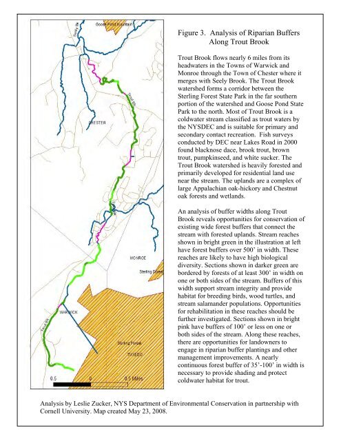
Figure 3. Analysis <strong>of</strong> Riparian Buffers<br />
Along Trout Brook<br />
Trout Brook flows nearly 6 miles from its<br />
headwaters in <strong>the</strong> Towns <strong>of</strong> Warwick and<br />
Monroe through <strong>the</strong> Town <strong>of</strong> Chester where it<br />
merges with Seely Brook. The Trout Brook<br />
watershed forms a corridor between <strong>the</strong><br />
Sterling Forest State Park in <strong>the</strong> far sou<strong>the</strong>rn<br />
portion <strong>of</strong> <strong>the</strong> watershed and Goose Pond State<br />
Park to <strong>the</strong> north. Most <strong>of</strong> Trout Brook is a<br />
coldwater stream classified as trout waters by<br />
<strong>the</strong> NYSDEC and is suitable for primary and<br />
secondary contact recreation. Fish surveys<br />
conducted by DEC near Lakes Road in 2000<br />
found blacknose dace, brook trout, brown<br />
trout, pumpkinseed, and white sucker. The<br />
Trout Brook watershed is heavily forested and<br />
primarily developed for residential land use<br />
near <strong>the</strong> stream. The uplands are a complex <strong>of</strong><br />
large Appalachian oak-hickory and Chestnut<br />
oak forests and wetlands.<br />
An analysis <strong>of</strong> buffer widths along Trout<br />
Brook reveals opportunities for conservation <strong>of</strong><br />
existing wide forest buffers that connect <strong>the</strong><br />
stream with forested uplands. Stream reaches<br />
shown in bright green in <strong>the</strong> illustration at left<br />
have forest buffers over 500’ in width. These<br />
reaches are likely to have high biological<br />
diversity. Sections shown in darker green are<br />
bordered by forests <strong>of</strong> at least 300’ in width on<br />
one or both sides <strong>of</strong> <strong>the</strong> stream. Buffers <strong>of</strong> this<br />
width support stream integrity and provide<br />
habitat for breeding birds, wood turtles, and<br />
stream salamander populations. Opportunities<br />
for rehabilitation in <strong>the</strong>se reaches should be<br />
fur<strong>the</strong>r investigated. Sections shown in bright<br />
pink have buffers <strong>of</strong> 100’ or less on one or<br />
both sides <strong>of</strong> <strong>the</strong> stream. Along <strong>the</strong>se reaches,<br />
<strong>the</strong>re are opportunities for landowners to<br />
engage in riparian buffer plantings and o<strong>the</strong>r<br />
management improvements. A nearly<br />
continuous forest buffer <strong>of</strong> 35’-100’ in width is<br />
necessary to provide shading and protect<br />
coldwater habitat for trout.<br />
Analysis by Leslie Zucker, NYS Department <strong>of</strong> Environmental Conservation in partnership with<br />
Cornell University. Map created May 23, 2008.