2011-10-28 suffolk historic landscape characterisation
2011-10-28 suffolk historic landscape characterisation
2011-10-28 suffolk historic landscape characterisation

Create successful ePaper yourself
Turn your PDF publications into a flip-book with our unique Google optimized e-Paper software.
Economy, Skills and Environment<br />
THE<br />
SUFFOLK<br />
HISTORIC LANDSCAPE CHARACTERISATION<br />
MAP<br />
Version 3<br />
2008<br />
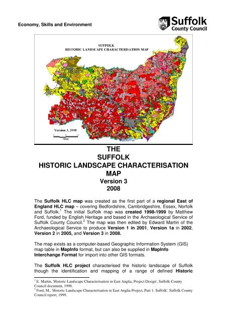
The Suffolk HLC map was created as the first part of a regional East of<br />
England HLC map – covering Bedfordshire, Cambridgeshire, Essex, Norfolk<br />
and Suffolk. 1 The initial Suffolk map was created 1998-1999 by Matthew<br />
Ford, funded by English Heritage and based in the Archaeological Service of<br />
Suffolk County Council. 2 The map was then edited by Edward Martin of the<br />
Archaeological Service to produce Version 1 in 2001, Version 1a in 2002,<br />
Version 2 in 2005, and Version 3 in 2008.<br />
The map exists as a computer-based Geographic Information System (GIS)<br />
map table in MapInfo format, but can also be supplied in MapInfo<br />
Interchange Format for import into other GIS formats.<br />
The Suffolk HLC project characterised the <strong>historic</strong> <strong>landscape</strong> of Suffolk<br />
though the identification and mapping of a range of defined Historic<br />
1 E. Martin, 'Historic Landscape Characterisation in East Anglia, Project Design', Suffolk County<br />
Council document, 1998.<br />
2 Ford, M., 'Historic Landscape Characterisation in East Anglia Project, Part 1: Suffolk'. Suffolk County<br />
Council report, 1999.
Landscape Types, each based on a current land use and an assessment<br />
of its <strong>historic</strong>al origin, thus giving the type a 'time depth'. This provides<br />
both a <strong>historic</strong>al context to descriptions of the Suffolk <strong>landscape</strong>, and a<br />
means to enhance understanding and management of <strong>historic</strong> <strong>landscape</strong>s.<br />
The Suffolk <strong>historic</strong> <strong>landscape</strong> types operate at two different levels:<br />
1. A set of 14 broad types which give a basic <strong>characterisation</strong>:<br />
1. Pre-18th-century enclosure<br />
2. 18th-century and later enclosure<br />
3. Post-1950 agricultural <strong>landscape</strong><br />
4. Common pasture<br />
5. Meadow or managed wetland<br />
6. Horticulture<br />
7. Woodland.<br />
8. Unimproved land<br />
9. Post-medieval park and leisure<br />
<strong>10</strong>. Built up area<br />
11. Industrial<br />
12. Post-medieval military<br />
13. Ancient monument<br />
14. Communications<br />
Due to their broad nature these types generally carry a high confidence<br />
rating.<br />
2. A nested set of 77 sub-types that give a closer definition of the broad<br />
types, e.g.:<br />
1.0 Pre-18th-century enclosure<br />
1.1 Random fields<br />
1.2 Rectilinear fields<br />
1.3 Long co-axial fields<br />
1.4 Irregular co-axial fields<br />
1.5 Former medieval deer park<br />
1.6 Former marsh or fenland<br />
1.7 Former coastal marsh<br />
Because of the higher level of interpretation needed to assign these subtypes,<br />
they generally carry a lower confidence rating.<br />
The Suffolk HLC map can be used at either the broad types or the sub-types<br />
level.
THE SUFFOLK HISTORIC LANDSCAPE CHARACTER TYPES<br />
Type 1.0. PRE-18 TH -CENTURY ENCLOSURE. This category refers to land that was<br />
enclosed into fields for agriculture before 1700. In most of Suffolk the <strong>landscape</strong> is one of<br />
‘ancient enclosure’, in contrast to areas like the Midlands, where extensive areas of common<br />
fields (large ‘open’ fields subdivided into separately-owned strips) were enclosed using<br />
parliamentary acts in the 18 th and 19 th centuries. In many of the areas of ‘ancient enclosure’ in<br />
Suffolk there is little evidence for a medieval phase of common-field farming: some areas had<br />
limited areas of common fields (as in north Suffolk) but in others there were none (as is often<br />
the case in south Suffolk). The identification of these earlier <strong>landscape</strong>s, which date back to<br />
medieval and in some cases even earlier, was a priority behind the development of the HLC<br />
mapping. These earlier <strong>landscape</strong>s are of great <strong>historic</strong> significance and have different<br />
management needs to later field systems.<br />
This <strong>landscape</strong> type covers a number of sub-types, as detailed below:<br />
• Sub-type 1.1. Pre-18 th -century enclosure – random fields. Landscapes made<br />
up of fields that have an irregular pattern (i.e. without any dominant axis). Many<br />
were in existence by the medieval period, but could be earlier. Boundaries are<br />
usually take the form of species-rich hedges (normally coppiced not laid) with<br />
associated ditches and banks. Areas with this field pattern are probably some of<br />
our earliest farming <strong>landscape</strong>s.<br />
• Sub-type 1.2. Pre-18 th -century enclosure – rectilinear fields. This is not a<br />
dominant type in Suffolk. Landscapes of this type are made up of fields that tend<br />
to be small and rectilinear in shape, forming patterns that resemble the brickwork<br />
in a wall. They tend to exist in isolated pockets within more extensive areas of<br />
other types of early enclosure, and probably indicate relatively late episodes of<br />
field creation or re-organisation, although still pre-18th century, within earlier<br />
surroundings.<br />
• Sub-type 1.3. Pre-18 th -century enclosure – long co-axial fields. Landscapes<br />
made up of fields where a high proportion of the boundaries share a dominant<br />
axis. This takes the form of long, slightly sinuous lines that run roughly parallel to<br />
each other for considerable distances. These lines usually run at right angles to a<br />
significant watercourse. Co-axial systems are not all of the same date – some in<br />
valley-side positions may represent very early farming boundaries, but others on<br />
the clay plateaux are likely to be medieval in date (as in parts of the South<br />
Elmhams).<br />
• Sub-type 1.4. Pre-18 th -century enclosure – irregular co-axial fields.<br />
Landscapes where many of the boundaries share a common axis. They share<br />
many of the characteristics of long co-axial fields (sub-type 1.3) but lack their<br />
overall regularity and their boundaries are often only approximately parallel. The<br />
systems vary in size, merge in and out of one another, and generally fail to follow<br />
one particular aspect or angle. In some cases these systems represent the early,<br />
piecemeal, enclosure of common fields.<br />
• Sub-type 1.5. Pre-18 th -century enclosure – former medieval deer park. Deer<br />
parks were important symbols of lordship in the medieval period and normally<br />
consisted of areas of woodland, wood pasture and open grassland (launds),<br />
bounded by banks and ditches with hedging and/or wooden fences to form a ‘park<br />
pale’. Park pales frequently have curved outlines as this was the most economic<br />
way of enclosing large areas. Deer parks were frequently situated on upland clay<br />
areas unsuited to agriculture and can therefore be at some distance from the<br />
lordship centre that they served. The parks functioned as deer farms, supplying<br />
venison for the lord’s table, with a variable amount of actual hunting. Parks could<br />
also include rabbit warrens and fishponds, also supplying food for the lord.<br />
Lodges within the parks supplied accommodation for a parker and/or a visiting<br />
lord. Some parks were in existence by <strong>10</strong>86, but the majority appear to have been<br />
active in the period 1200-1400. Most were ‘disparked’ by the 16 th Century and<br />
turned over to agriculture, but the legacy in the <strong>landscape</strong> can survive, in terms of<br />
names, field patterns and boundary features<br />
• Sub-type 1.6. Pre-18 th -century enclosure – former marsh or fenland. Areas of<br />
inland marsh or fen that was enclosed before 1700. Enclosures frequently have<br />
curvilinear boundaries and drainage ditches, often reflecting pre-existing channels<br />
and streams.<br />
• Sub-type 1.7. Pre-18 th -century enclosure – former coastal marsh. Areas of<br />
coastal marsh that was enclosed before 1700. Enclosures frequently have
curvilinear boundaries and drainage ditches, often reflecting pre-existing channels<br />
and creeks.<br />
• Sub-type 1.8. Pre-18 th -century enclosure – planned allotments. Areas of<br />
fenland that were allotted to ‘adventurers’ (i.e. investors) in the 17 th -century fen<br />
drainage enterprises. These are characterised by their straight-edged, geometric<br />
shapes associated with straight drains and roads. They may also have a<br />
farmstead set within a block of fields.<br />
Type 2.0. 18 TH -CENTURY AND LATER ENCLOSURE. Advances in farming techniques,<br />
allied to significant social changes concerning the holding of land resulted in the ‘agricultural<br />
revolution’ of the 18 th century. Prominent amongst the changes was the ending of the system<br />
of common-field farming whereby farmers cultivated separately-owned strips in large ‘open’<br />
fields. Some common fields were enclosed by means of parliamentary acts, while others were<br />
enclosed by agreement. This type of ‘planned’ enclosure resulted in a <strong>landscape</strong> with<br />
regularly-shaped units with straight boundaries. Boundaries are usually composed of singlespecies<br />
hedges (usually hawthorn) or tree lines (e.g. the ‘pine lines’ of Breckland). Common<br />
fields were present in large parts of north-west Suffolk and, to a lesser extent, in the Stour<br />
Valley and the Sandlings, but were much less frequent in other parts of Suffolk, being absent<br />
in many parts of south Suffolk. Agricultural advancements in draining, fertilising and irrigation<br />
also resulted in the conversion of areas of common pasture, heath, fen and marsh to arable.<br />
This <strong>landscape</strong> type contains the following sub-types:<br />
• Sub-type 2.1. 18 th -century and later enclosure – former common arable or<br />
heathland.. Fields formed from land that was previously farmed as individuallyowned<br />
strips in large common or ‘open’ fields. Field shapes are frequently<br />
rectangular with straight boundaries, as a result of having been laid out to<br />
measured plans by surveyors. In the Breckland region of north-west Suffolk there<br />
temporary intakes from the heaths (called 'brecks'), which were cultivated for a<br />
short time and then abandoned to slowly recover their fertility. Similar temporary<br />
intakes occurred in the Sandlings of south-east Suffolk. As a result of this<br />
practice, the dividing line between heathland and common fields can be difficult to<br />
distinguish, hence the inclusion of heathland in the title of this sub-type.<br />
• Sub-type 2.2. 18 th -century and later enclosure – former common pasture,<br />
built margin.. Pastures of this type were usually called greens, but can also be<br />
termed tyes (in south Suffolk only) or commons. They are normally situated on<br />
poorly-drained clay plateaux and are medieval in origin. The greens were usually<br />
surrounded by substantial ditches, often water-filled and hedged on the outer<br />
margin, which frequently survive as substantial <strong>landscape</strong> features. Enclosure<br />
was often achieved though parliamentary acts and frequently involved the<br />
insertion of distinctive straight roads through the centres of the former greens.<br />
New straight boundaries were laid off at right-angles to these roads and many of<br />
the smaller land parcels were utilised as house plots. This leads to a distinctive<br />
<strong>landscape</strong> where the older houses are set back from the road on the old margin,<br />
reached by a series of individual driveways, and newer house flanking the<br />
inserted road. Deserted house sites, often showing now only as scatters of<br />
pottery, also occur on the margins.<br />
• Sub-type 2.3. 18 th -century and later enclosure – former common pasture,<br />
open margin. Fields formed from the enclosure and sub-division of areas of<br />
common pasture that were not a focus for settlement and therefore, now and<br />
<strong>historic</strong>ally, had few or no houses on their margins. Common pastures of this type<br />
were frequently either heaths on impoverished dry sandy soils or wet riverine<br />
grasslands.<br />
• Sub-type 2.4. 18 th -century and later enclosure – former post-medieval park.<br />
Parkland designed to appear semi-natural with clumps of trees within extensive<br />
grassland and frequently fringed by belts of trees to give privacy and to exclude<br />
unwanted views. Usually designed as the setting for a great house and laid out to<br />
give vistas from that house. Lakes and decorative buildings or structures can form<br />
part of the layouts. Entrances are often guarded by lodges. Most examples are<br />
18 th or 19 th century in date, though earlier examples do occur. Traces of earlier<br />
<strong>landscape</strong>s, like trees that were formerly part of field hedges sometimes can be<br />
detected.<br />
• Sub-type 2.5. 18 th -century and later enclosure – former marsh or fenland.<br />
Land reclaimed, through drainage and embankment, from inland marsh or fen<br />
and converted into farmland, usually pasture, but also arable when conditions are<br />
suitable. The field pattern usually appears planned, with straight ditches or drains.
The land may previously have been held in common and may have been subject<br />
to earlier reclamation attempts.<br />
• Sub-type 2.6. 18 th -century and later enclosure – former coastal marsh. Land<br />
reclaimed, through drainage and embankment, from coastal marsh. and<br />
converted into farmland, usually pasture, but also arable when conditions are<br />
suitable. The drainage pattern usually appears planned, with straight ditches or<br />
drains. Substantial sea banks normally protect the reclaimed land. Sluices and<br />
pumping mills frequently occur. The land may previously have been held in<br />
common and may have been subject to earlier reclamation attempts.<br />
• Sub-type 2.7. 18 th -century and later enclosure – woodland clearance. Fields<br />
created as a result of woodland clearance. The former wood boundary often<br />
survives as a curving field boundary, but internal subdivisions usually have<br />
straight boundaries.<br />
• Sub-type 2.8. 18 th -century and later enclosure – former warren. Former rabbit<br />
warrens enclosed and converted into farmland. Warrens, often sited on<br />
heathland, are documented from the 12 th century onwards, but few, if any,<br />
survived in active management beyond the early part of the 20 th century. Warrens<br />
were frequently enclosed within earthen banks, which may survive as field<br />
boundaries. Disused warrener’s lodges may also occur.<br />
• Sub-type 2.9. 18 th -century and later enclosure – former heath. The enclosure<br />
and conversion to arable or pasture of land that was formerly of Sub-type 8.1<br />
(Unimproved land – heath or rough pasture): Areas of natural or semi-natural<br />
vegetation (particularly grass and heather) on dry, acidic soils. Historically too dry<br />
and impoverished for arable cultivation, they were managed mainly as areas of<br />
sheep pasture (often called ‘sheep walks’). Some areas of heathland had<br />
experienced intermittent arable cultivation (termed ‘brecks’ in Breckland and<br />
sometimes as ‘ol(d)land’ elsewhere). Where there has been minimal cultivation<br />
there are often earthworks of archaeological interest, such as pre<strong>historic</strong> burial<br />
mounds.<br />
• Sub-type 2.11. 18 th -century and later enclosure – former mere. Former mere<br />
or natural lake that has been drained and converted into arable land. Parts of the<br />
former mere outline may survive in the land boundaries, but boundaries within the<br />
former mere will tend to take the form of straight drains.<br />
Type 3.0. POST-1950 AGRICULTURAL LANDSCAPE. Areas that have had their character<br />
altered as a result of agricultural changes in the post-war period. Historic field patterns have<br />
disappeared or been weakened through the removal and remodelling of hedges and other<br />
field boundaries. Other important changes are in landuse, as in the conversion of meadows<br />
into arable land. Overall, these changes have produced 20 th -century <strong>landscape</strong>s, but aspects<br />
of their previous character can be determined by reference to earlier mapping, such as the 1 st<br />
edition Ordnance Survey (see maps provided) or tithe maps. The following subdivisions are<br />
based on their earlier character, some traces of which frequently remain:<br />
• Sub-type 3.1. Post-1950 agricultural <strong>landscape</strong> – boundary loss from<br />
random fields. 20 th -century boundary loss from fields formerly of Sub-type 1.1<br />
(random fields): Landscapes made up of fields that have an irregular pattern (i.e.<br />
without any dominant axis). Many were in existence by the medieval period, but<br />
could be earlier. Boundaries usually take the form of species-rich hedges<br />
(normally coppiced not laid) with associated ditches and banks. Areas with this<br />
field pattern are probably some of our earliest farming <strong>landscape</strong>s.<br />
• Sub-type 3. Post-1950 agricultural <strong>landscape</strong> – boundary loss from<br />
rectilinear fields. 20 th -century boundary loss from fields formerly of Sub-type 1.2<br />
(Pre-18 th -century enclosure – rectilinear fields): This is not a dominant type in<br />
Suffolk. Landscapes of this type are made up of fields that tend to be small and<br />
rectilinear in shape, forming patterns that resemble the brickwork in a wall. They<br />
tend to exist in isolated pockets within more extensive areas of other types of<br />
early enclosure, and probably indicate relatively late episodes of field creation or<br />
re-organisation, although still pre-18th century, within earlier surroundings.<br />
• Sub-type 3.3. Post-1950 agricultural <strong>landscape</strong>– boundary loss from long<br />
co-axial fields. 20 th -century boundary loss from fields formerly of Sub-type 1.3<br />
(Pre-18 th -century enclosure – long co-axial fields): Landscapes made up of fields<br />
where a high proportion of the boundaries share a dominant axis. This takes the<br />
form of long, slightly sinuous lines that run roughly parallel to each other for<br />
considerable distances. These lines usually run at right angles to a significant<br />
watercourse. Co-axial systems are not all of the same date – some in valley-side
positions may represent very early farming boundaries, but others on the clay<br />
plateaux are likely to be medieval in date (as in parts of the South Elmhams).<br />
• Sub-type 3.4. Post-1950 agricultural <strong>landscape</strong> – boundary loss from<br />
irregular co-axial fields. 20 th -century boundary loss from fields formerly of Subtype<br />
1.4 (Pre-18 th -century enclosure – irregular co-axial fields): Landscapes where<br />
many of the boundaries share a common axis. They share many of the<br />
characteristics of long co-axial fields (sub-type 1.3) but lack their overall regularity<br />
and their boundaries are often only approximately parallel. The systems vary in<br />
size, merge in and out of one another, and generally fail to follow one particular<br />
aspect or angle. In some cases these systems represent the early, piecemeal,<br />
enclosure of common fields.<br />
• Sub-type 3.5. Post-1950 agricultural <strong>landscape</strong> – boundary loss from post-<br />
1700 fields. 20 th -century boundary loss from fields that were enclosed after 1700.<br />
This sub-type includes both fields created through the enclosure of common fields<br />
and fields created through the enclosure of other types of land. Boundaries, where<br />
they survive, are usually straight and are composed of single-species hedges.<br />
• Sub-type 3.6. Post-1950 agricultural <strong>landscape</strong> – woodland clearance.<br />
Agricultural land created through woodland clearance in the post-war period. The<br />
former wood boundary may survive as a curving field boundary, but internal<br />
subdivisions usually have straight boundaries.<br />
• Sub-type 3.7. Post-1950 agricultural <strong>landscape</strong> – arable on former meadow.<br />
20 th -century conversion to arable of land that was formerly of Sub-type 5.1<br />
(Meadow or managed wetland – meadow): Seasonally wet grassland that is<br />
mown for hay and/or grazed by animals. Normally found alongside rivers and<br />
streams and characteristically takes the form of long and narrow land parcels that<br />
run parallel to the watercourses. Often hedged on the dry-land side, but with<br />
ditched internal sub-divisions that often have a drainage function.<br />
• Sub-type 3.8. Post-1950 agricultural <strong>landscape</strong>– arable on former heath.<br />
20 th -century conversion to arable of land that was formerly of Sub-type 8.1<br />
(Unimproved land – heath or rough pasture): Areas of natural or semi-natural<br />
vegetation (particularly grass and heather) on dry, acidic soils. Historically too dry<br />
and impoverished for arable cultivation, they were managed mainly as areas of<br />
sheep pasture (often called ‘sheep walks’). Some areas of heathland had<br />
experienced intermittent arable cultivation (termed ‘brecks’ in Breckland and<br />
sometimes as ‘ol(d)land’ elsewhere). Where there has been minimal cultivation<br />
there are often earthworks of archaeological interest, such as pre<strong>historic</strong> burial<br />
mounds.<br />
• Sub-type 3.8. Post-1950 agricultural <strong>landscape</strong> – boundary loss, enclosed<br />
medieval deer park. 20 th -century boundary loss from an area of land that was<br />
formerly of Sub-type 1.5 (Pre-18 th -century enclosure – former medieval deer<br />
park): Deer parks were important symbols of lordship in the medieval period and<br />
normally consisted of areas of woodland, wood pasture and open grassland<br />
(launds), bounded by banks and ditches with hedging and/or wooden fences to<br />
form a ‘park pale’. Park pales frequently have curved outlines as this was the<br />
most economic way of enclosing large areas. Deer parks were frequently situated<br />
on upland clay areas unsuited to agriculture and can therefore be at some<br />
distance from the lordship centre that they served. The parks functioned as deer<br />
farms, supplying venison for the lord’s table, with a variable amount of actual<br />
hunting. Parks could also include rabbit warrens and fishponds, also supplying<br />
food for the lord. Lodges within the parks supplied accommodation for a parker<br />
and/or a visiting lord. Some parks were in existence by <strong>10</strong>86, but the majority<br />
appear to have been active in the period 1200-1400. Most were ‘disparked’ by the<br />
16 th Century and turned over to agriculture, but the legacy in the <strong>landscape</strong> can<br />
survive, in terms of names, field patterns and boundary features<br />
Type 4.0. COMMON PASTURE. Areas of pasture that were/are grazed communally. The<br />
number and types of animals that were allowed on the pastures was regulated by the manorial<br />
courts and the common-right holders. These common rights can be termed gates, goings,<br />
shares or stints. Other common rights can include rights to take fuel (often gorse or ‘furze’)<br />
and clay, sand or other ‘stone’. This <strong>landscape</strong> type contains the following sub-types:<br />
• Sub-type 4.1. Common pasture – built margin.. Common pastures on the<br />
claylands were usually enclosed by a substantial ditch, often water-filled, and can<br />
be hedged on the outer margin. Their shapes can be very varied, but they<br />
frequently have funnel-shaped extensions where roads enter them, presumably
to help with the herding of animals. Usually called greens, they can also be<br />
termed tyes (in south Suffolk only) or commons. Small greens are often triangular<br />
and arranged around the junction of three roads. Large greens (over 20ha) are a<br />
particular feature of the clay plateaux of north Suffolk. Farmsteads and cottages<br />
fringe the margins of the greens and these usually have or had common rights<br />
attached to them. Deserted house sites, often showing now only as scatters of<br />
pottery, also occur on the margins. Windmills frequently occur within or on the<br />
margin of greens. Greens seem to have been established from the 12 th century<br />
onwards and usually occur on poorly-drained clay plateaux.<br />
• Sub-type 4.2. Common pasture – open margin. Areas of common pasture that<br />
were not a focus for settlement, and therefore, now and <strong>historic</strong>ally, had few or no<br />
houses on their margins. Common pastures of this type are frequently either<br />
heaths on impoverished sandy soils or wet riverine grasslands. There is therefore<br />
an overlap with types 5 (meadow or managed wetland) and 8 (unimproved land).<br />
Type 5.0. MEADOW OR MANAGED WETLAND. Wet grassland or land with other non-woody<br />
wetland vegetation that is enclosed and managed. This <strong>landscape</strong> type contains the following<br />
sub-types:<br />
• Sub-type 5.1. Meadow or managed wetland – meadow. Seasonally wet<br />
grassland that is mown for hay and/or grazed by animals. Normally found<br />
alongside rivers and streams and characteristically takes the form of long and<br />
narrow land parcels that run parallel to the watercourses. Often hedged on the<br />
dry-land side, but with ditched internal sub-divisions that often have a drainage<br />
function.<br />
• Sub-type 5.2. Meadow or Managed wetland – meadow with modern<br />
boundary loss. Boundary loss from seasonally wet grassland that is mown for<br />
hay and/or grazed by animals. Meadows are normally found alongside rivers and<br />
streams and characteristically take the form of long and narrow land parcels that<br />
run parallel to the watercourses. The lost boundaries can be either the hedges on<br />
the dry-land side or the ditched internal sub-divisions that often had a drainage<br />
function.<br />
• Sub-type 5.3. Meadow or managed wetland – managed wetland. Wetland with<br />
a non-woody vegetation that is enclosed and managed. This sub-type includes<br />
grazed marshland and managed reed beds.<br />
• Sub-type 5.4. Meadow or managed wetland – former mere. Former mere or<br />
natural lake that has been drained and converted into pasture or other form of<br />
managed wetland. Parts of the former mere outline may survive in the land<br />
boundaries, but boundaries within the former mere will tend to take the form of<br />
straight drains.<br />
Type 6.0. HORTICULTURE.<br />
• Sub-type 6.1. Horticulture – orchard. Land planted with fruit trees, often<br />
arranged in straight rows.<br />
• Sub-type 6. Horticulture – nurseries with glass houses. Land used for<br />
commercial plant growing, involving the use of glass-houses.<br />
• Sub-type 6.3 Horticulture – allotments. An area divided into small plots which<br />
are annually leased by individuals to grow flowers and vegetables. 19 th -century<br />
and later in date.<br />
• Sub-type 6.4. Horticulture – market gardens. Land used for the commercial<br />
growing of vegetables in small-scale operations.<br />
• Sub-type 6.5. Horticulture – plotlands. Small plots of agricultural land sold to<br />
people, mainly from the poorer districts of London, in the first half of the 20 th<br />
century and used as smallholdings and/or homesteads that were often small<br />
bungalows or shacks, often without services and served by poorly-maintained<br />
roads. The practice was ended by the 1947 Town and Country Planning Act.<br />
Particularly to be found in Essex (Basildon, Jaywick Sands etc). Included are the<br />
lands of the Newbourne Land Settlement Scheme for unemployed miners in<br />
Suffolk (1935-?82).<br />
Type 7.0. WOODLAND. Woodland has been part of the Suffolk <strong>landscape</strong> since pre<strong>historic</strong><br />
times. In the <strong>historic</strong>al period, woodland was a fundamental rural resource, providing wood for<br />
fuel and and timber for construction purposes, as well as a place for hunting, rough pasture<br />
and swine forage. The type includes both ancient woodland and modern plantations and is<br />
subdivided into these sub-types:<br />
• Sub-type 7.1. Woodland – ancient woodland. Areas of deciduous woodland of<br />
‘ancient’ character. This includes all the woodland defined as ‘ancient’ in the
Nature Conservation Council survey of 1992. In their view, ancient woodland sites<br />
are those which have had a continuous woodland cover since at least 1600 to the<br />
present day and to have only been cleared for ‘underwood’ (coppice poles and/or<br />
firewood) and/or timber production. A wood present in 1600 was likely to have<br />
been in existence for centuries. This date was adopted as a threshold for two<br />
important reasons: firstly, it roughly marked the time when plantation forestry was<br />
widely adopted and, secondly, the period when detailed maps first start to appear.<br />
Ancient woods were frequently enclosed within wood banks and may contain<br />
internal sub-divisions.<br />
• Sub-type 7.2. Woodland – former medieval deer park. Deer parks were<br />
important symbols of lordship in the medieval period and normally consisted of<br />
areas of woodland, interspersed with more open areas of wood pasture and<br />
grassland glades (launds), bounded by banks and ditches with hedging and/or<br />
wooden fences to form a ‘park pale’. Park pales frequently have curved outlines<br />
as this was the most economic way of enclosing large areas. Deer parks were<br />
frequently situated on upland clay areas unsuited to agriculture and can therefore<br />
be at some distance from the lordship centre that they served. The parks<br />
functioned as deer farms, supplying venison for the lord’s table, with a variable<br />
amount of actual hunting. Parks could also include rabbit warrens and fishponds,<br />
also supplying food for the lord. Lodges within the parks supplied accommodation<br />
for a parker and/or a visiting lord. Some parks were in existence by <strong>10</strong>86, but the<br />
majority appear to have been active in the period 1200-1400. Many had fallen into<br />
disuse by the 16 th century, but some continued in existence as woodland.<br />
• Sub-type 7.3. Woodland – modern plantation on former arable. Plantations,<br />
often coniferous, on land that can be shown, on map evidence, to have been<br />
farmland in the 19 th or 20 th century. The plantations usually form rectangular<br />
blocks or other regular linear or geometric shapes.<br />
• Sub-type 7.4. Woodland – modern plantation on former common arable or<br />
heath. Plantations, often coniferous, on land that was formerly common arable<br />
land or intermittently cultivated heathland. The plantations were often introduced<br />
when the land was enclosed in the 18 th and 19 th centuries and usually take the<br />
form of rectangular blocks or other regular linear or geometric shapes. This subtype<br />
also includes much of the substantial coniferous forests that were planted by<br />
the Forestry Commission from the 1920s onwards in Breckland (Thetford Forest)<br />
and the Sandlings (Rendlesham and Dunwich Forests).<br />
• Sub-type 7.5. Woodland – modern plantation on former common pasture.<br />
Plantations established on former commons or greens after their enclosure,<br />
usually in the 18 th or 19 th centuries. The plantations usually form rectangular<br />
blocks or other regular linear or geometric shapes. Woodland – modern plantation<br />
on former informal park (Sub-type 7.6). Plantations established on former informal<br />
parkland after its conversion to farmland, usually in the 20 th century. The<br />
plantations are usually rectangular in plan.<br />
• Sub-type 7.6. Woodland – modern plantation on former informal park.<br />
Plantations established on former areas of informal parkland after the park was<br />
converted to other uses. Frequently these plantations are of mid-20 th century date,<br />
coniferous, and form rectangular blocks or other regular linear or geometric<br />
shapes.<br />
• Sub-type 7.7. Woodland – modern plantation on former warren. Plantations<br />
established on former rabbit warrens after their enclosure, often in 20 th century.<br />
The plantations usually form rectangular blocks or other regular linear or<br />
geometric shapes. This sub-type includes substantial areas of the coniferous<br />
forest that was planted by the Forestry Commission from the 1920s onwards in<br />
Breckland (Thetford Forest). Warrens are documented from the 12 th century<br />
onwards, but few, if any, survived in active management beyond the early part of<br />
the 20 th century. Warrens were frequently enclosed within earthen banks, which<br />
often survive within, or surround the plantations. Disused warreners’ lodges can<br />
also occur (as at Mildenhall).<br />
• Sub-type 7.8. Woodland – wet woodland or alder carr. This sub-type includes<br />
both ancient wet woodland characterised by a predominance of alder (and<br />
sometimes specifically named as ‘alder carr’) and more recent natural<br />
regeneration in poorly maintained or grazed meadows.<br />
• Sub-type 7.9. Woodland – modern plantation on former meadow. 20 th -century<br />
plantations on former meadows.
• Sub-type 7.11. Woodland – modern plantation on former heath. Plantations<br />
on former heathland. The plantations usually form rectangular blocks or other<br />
regular linear or geometric shapes.. This sub-type includes areas of coniferous<br />
forest that was planted by the Forestry Commission from the 1920s onwards in<br />
Breckland (Thetford Forest) and the Sandlings (Rendlesham and Dunwich<br />
Forests).<br />
• Sub-type 7.12. Woodland – wooded common. Areas of common land that<br />
have traditionally been managed as woodland, or natural regeneration on<br />
insufficiently grazed common pastures.<br />
• Sub-type 7.13. Woodland – park wood. Areas of woodland planted as part of<br />
post-medieval <strong>landscape</strong> parks. Includes both internal groves and tree belts that<br />
act as the park boundaries.<br />
• Sub-type 7.14. Woodland – modern plantation on former fenland. Largely<br />
20 th -century plantations on drained former fenland.<br />
Type 8. UNIMPROVED LAND. Areas of natural or semi-natural vegetation that have not<br />
undergone agricultural improvement. These are frequently areas of great significance for<br />
wildlife and may be designated as nature reserves. This <strong>landscape</strong> type contains the following<br />
sub-types:<br />
• Sub-type 8.1, Unimproved land – heath or rough pasture. Areas of natural or<br />
semi-natural vegetation (particularly grass and heather) on dry, acidic soils.<br />
Historically too dry and impoverished for arable cultivation, they were managed<br />
mainly as areas of sheep pasture (often called ‘sheep walks’). Under the<br />
foldcourse system, sheep were put to graze on the heaths during the day and<br />
folded (enclosed within temporary hurdle fences) overnight on the arable land to<br />
enrich it with their dung. Some areas of heathland have experienced intermittent<br />
arable cultivation (termed ‘brecks’ in Breckland and sometimes as ‘ol(d)land’<br />
elsewhere). Where there has been minimal cultivation there are often earthworks<br />
of archaeological interest, such as pre<strong>historic</strong> burial mounds. Lack of grazing in<br />
the 20 th century has resulted in the growth of scrub and bracken on many heaths.<br />
• Sub-type 8.2. Unimproved land – heath, former warren. Areas of natural or<br />
semi-natural vegetation (particularly grass and heather) on dry, acidic soils that<br />
were used as rabbit warrens. Warrens are documented from the 12 th century<br />
onwards, but few, if any, survived in active management beyond the early part of<br />
the 20 th century. Warrens were frequently enclosed within earthen banks and may<br />
contain mounds for the rabbits to burrow into. Internal lodges for the warreners<br />
also occur. Some of the largest warrens occurred in Breckland (e.g. Lakenheath<br />
Warren was 2300 acres (931 ha).<br />
• Sub-type 8.3. Unimproved land – freshwater fen or marsh. An inland marsh<br />
occupying low-lying poorly-drained wet land. Fens were formerly a particular<br />
feature of the extreme north-west of the county where they covered many<br />
thousand acres, forming the south-eastern edge of the extensive fenland basin<br />
that stretched westward into Cambridgeshire and northwards into Norfolk. Major<br />
drainage and reclamation works started in the 17 th century and little undrained<br />
land remained by the mid 19 th century. Fens or marshes also occur in river<br />
valleys. Historically, the seasonally drier areas were managed for summer grazing<br />
and the wetter areas were cropped for reeds and used for wildfowling, eel<br />
fisheries and peat digging. Surviving fens/marshes are now frequently nature<br />
reserves and are only cropped to preserve their ecological integrity.<br />
• Sub-type 8.4. Unimproved land – coastal marsh. Low-lying areas adjacent to<br />
the sea or estuarine inlets, subject to regular or occasional salt-water inundations.<br />
Coastal marshes were <strong>historic</strong>ally an important part of coastal economies,<br />
providing reeds, eels and seasonal rough pasture. Many have been drained and<br />
enclosed during the last three hundred years. Those that remain are frequently<br />
nature reserves now.<br />
• Sub-type 8.5. Unimproved land – intertidal land. Low lying coastal areas<br />
subject to regular tidal inundations. Economically this <strong>landscape</strong> type has been<br />
utilised as a base for fish traps which capitalise on the tidal flow, a process which<br />
is likely to have been occurring since at least the Anglo-Saxon period, and<br />
possibly much earlier. This <strong>landscape</strong> type is physically unstable, and usually too<br />
costly and impractical to reclaim for agriculture. Reclamation for high capital<br />
industrial projects, such as quayside development around Felixstowe, can<br />
sometimes occur.
• Sub-type 8.6. Unimproved land – shingle spit. Linear accumulations of shingle<br />
on the coast, as at Orford Ness where there is an eleven-mile long spit, the<br />
largest formation of its kind on the east coast.<br />
• Sub-type 8.7. Unimproved land – mere. A natural lake, often resulting from<br />
depressions in the post-glacial <strong>landscape</strong>. Meres are likely to contain sediments<br />
with a high palaeo-enviromental value.<br />
• Sub-type 8.8. Unimproved land – broad. A large body of water resulting from<br />
the flooding of extensive medieval peat diggings or turbaries. The peat or ‘turf’<br />
was extracted and dried for fuel. Broads are best-known from those in Norfolk<br />
(giving rise to the area name of ‘Broadland’ or ‘The Broads’) but also extend along<br />
the Waveney and its tributaries into Suffolk. They have been classified as ‘bypassed<br />
broads’ where they are on the sides of major river valleys (eg. Barnby<br />
Broad in the Waveney valley) and ‘side-valley broads’ where they occupy tributary<br />
valleys (eg. Outon Broad). Some were later used for other purposes, eg as duck<br />
decoys, as at Fritton Decoy.<br />
Type 9. POST-MEDIEVAL PARK AND LEISURE. Open areas, frequently grassed, and<br />
sometimes with terrain landscaping. Where trees, patches of woodland, water features or built<br />
structures occur they frequently have designed positions or shapes that are intended to<br />
contribute to the aesthetic character of the <strong>landscape</strong>.<br />
• Sub-type 9.1 .Post-medieval park and leisure – formal park or garden. A park<br />
or garden with a formal or geometric arrangement. These are usually late-17 th - or<br />
early 18 th -century in date and normally associated with a great house and having<br />
an axial relationship to it.<br />
• Sub-type 9.2. Post-medieval park and leisure – informal park. Parkland<br />
designed to appear semi-natural with clumps of trees within extensive grassland<br />
and frequently fringed by belts of trees to give privacy and to exclude unwanted<br />
views. Usually designed as the setting for a great house and laid out to give vistas<br />
from that house. Lakes and decorative buildings or structures can form part of the<br />
layouts. Entrances are often guarded by lodges. Most examples are 18 th or 19 th<br />
century in date, though earlier examples do occur. Traces of earlier <strong>landscape</strong>s,<br />
like trees that were formerly part of hedge lines can sometimes be detected.<br />
• Sub-type 9.3. Post-medieval park and leisure – modern leisure. The growth of<br />
leisure as an ‘industry’ during the 20th century has led to the creation of many<br />
‘leisure <strong>landscape</strong>s’ within previously rural or marginal areas. This sub-type<br />
includes extensive modern <strong>landscape</strong> features such as golf courses, playing fields<br />
and camp/caravan sites.<br />
Type <strong>10</strong>.0. BUILT UP AREA.<br />
• Sub-type <strong>10</strong>.1. Built up area – unspecified. A built up area of unspecified type<br />
or size. [This type is also being used temporarily for all the former undifferentiated<br />
<strong>10</strong>.0 land types].<br />
• Sub-type <strong>10</strong>.2. Built up area – town. Large settlement with urban functions.<br />
Historically, this sub-type includes the places that had functioning markets.<br />
• Sub-type <strong>10</strong>.3. Built up area – village. Substantial groups of houses associated<br />
with a parish church.<br />
• Sub-type <strong>10</strong>.4. Built up area – hamlet. Small groups of houses.<br />
• Sub-type <strong>10</strong>.5. Built up area – green edge or infill). Houses on the edge of<br />
greens or inserted into former greens after their enclosure. Greens seem to have<br />
been established from the 12 th century onwards and usually occur on poorlydrained<br />
clay plateaux.<br />
• Sub-type <strong>10</strong>.6. Built up area – house or farmstead. An individual house or a<br />
farmstead with its associated agricultural buildings.<br />
• Sub-type <strong>10</strong>.7. Built up area – isolated church. Medieval churches which stand<br />
by themselves.<br />
Type 11.0. INDUSTRIAL. Land used for an industrial purpose.<br />
• Sub-type 11.1. Industrial – current industrial <strong>landscape</strong>. Areas in active use<br />
for an industrial purpose.<br />
• Sub-type 11.2. Industrial – disused industrial <strong>landscape</strong>. Areas in former use<br />
for an industrial purpose.<br />
• Sub-type 11.3. Industrial – current mineral extraction. Areas in active use for<br />
mineral extraction. Minerals extracted are, in this region, usually, sand, gravel,<br />
clay and chalk.
• Sub-type 11.4. Industrial – disused mineral extraction. Areas in former use for<br />
mineral extraction. Minerals extracted were, in this region, usually, sand, gravel,<br />
clay and chalk.<br />
• Sub-type 11.5. Industrial – water reservoir. Area used for the storage of water,<br />
either for human use or for farmland irrigation.<br />
Type 12.0. POST-MEDIEVAL MILITARY. Land used for substantial military establishments.<br />
• Sub-type 12.1. Post-medieval military – current military. Land used for military<br />
establishments. Particularly prominent in this region are the large 20 th -century air<br />
bases, as at Lakenheath and Mildenhall.<br />
• Sub-type 12.2. Post-medieval military – disused military. Land formerly used<br />
for military establishments.<br />
Type 13.0. ANCIENT MONUMENT. Land managed as an ancient monument.<br />
• Sub-type 13.1. Ancient monument. Land managed as an ancient monument,<br />
eg. Framlingham Castle.<br />
Type 14.0. COMMUNICATIONS. Land used for major communication routes.<br />
• Sub-type 14.1. Communications – major road. Substantial trunk roads that are<br />
major <strong>landscape</strong> features.<br />
• Sub-type 14.2. Communications – railway. Railway lines in current use.<br />
For further and detailed discussion of the Suffolk <strong>historic</strong> <strong>landscape</strong> character<br />
types in the wider context of the <strong>historic</strong> <strong>landscape</strong> of East Anglia see:<br />
E. Martin and M. Satchell, Wheare most Inclosures be. East Anglian Fields:<br />
History, Morphology and Management, East Anglian Archaeology monograph<br />
series no. 124, 2008, obtainable from the Archaeological Service of Suffolk<br />
County Council or from www.eaareports.org.uk<br />
For further information on Historic Landscape Characterisation at a national<br />
level see: www.helm.org.uk/server/show/nav.19604<br />
The Suffolk Historic Landscape Characterisation results have also contributed to the<br />
Suffolk Landscape Character Assessment (http://www.<strong>suffolk</strong><strong>landscape</strong>.org.uk ), to<br />
the Stour Valley Historic Landscape Study<br />
(http://www.managingamasterpiece.org/images/stories/documents/Doc%202%20Lan<br />
dscape%20Character%20Study.pdf) and to the East of England Landscape<br />
Typology (http://<strong>landscape</strong>-east.org.uk/east-england-<strong>landscape</strong>-typology)<br />
Edward Martin<br />
The Archaeological Service<br />
Suffolk County Council<br />
9-<strong>10</strong> The Churchyard, Shire Hall<br />
Bury St Edmunds<br />
Suffolk<br />
IP33 1RX<br />
Telephone: 01<strong>28</strong>4-741229<br />
Fax no.: 01<strong>28</strong>4-741257<br />
e-mail: edward.martin@<strong>suffolk</strong>.gov.uk