The Green Light Plan
The Green Light Plan
The Green Light Plan

You also want an ePaper? Increase the reach of your titles
YUMPU automatically turns print PDFs into web optimized ePapers that Google loves.
Q4<br />
2011<br />
<strong>Green</strong> <strong>Light</strong> <strong>Plan</strong><br />
Building Better Roads for East Baton Rouge Parish<br />
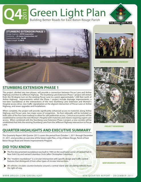
STUMBERG EXTENSION PHASE 1<br />
Design Engineer: HNTB Corporation<br />
Contractor: J. B. James Construction, LLC<br />
Construction Cost: $6.3M<br />
Project Length: 5,700 ft<br />
GROUNDBREAKING CEREMONY<br />
STUMBERG EXTENSION PHASE 1<br />
<strong>The</strong> project, divided id d into two phases, will provide a connection between Pecue Lane and Airline<br />
Highway and then to Jefferson Highway. <strong>The</strong> Stumberg Lane Extension Phase 1 project will stretch<br />
from the 90-degree turn on the existing Pecue Lane to a point approximately 1,300 feet north of<br />
Airline Highway. Improvements within the Phase 1 project include drainage improvements, a<br />
two-lane roundabout at the intersections of the new Stumberg Lane Extension and Woman’s<br />
Hospital access drive, new traffic signalization at the aligned intersection of Pecue Lane at Airline<br />
Highway, and sewer upgrades and installations.<br />
When complete, the project will provide significantly enhanced access to motorists along Airline<br />
Highway and Pecue Lane, two major areas of congestion. Six-foot sidewalks will be included on<br />
both sides of the four-lane roadway to allow for safe pedestrian access. Critical access points will be<br />
established to connect the new Woman’s Hospital with motorists and citizens requiring urgent care<br />
access. When combined with the Stumberg Lane Extension Phase 2 project, a new corridor will be<br />
established that links the existing Stumberg Lane from the Jefferson Highway intersection to Pecue<br />
Lane.<br />
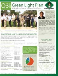
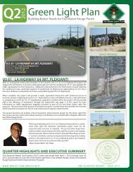
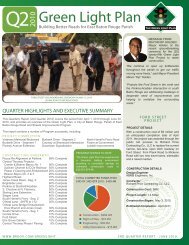
QUARTER HIGHLIGHTS AND EXECUTIVE SUMMARY<br />
This Quarterly Report (4th Quarter 2011) covers the period from October 1, 2011 through December<br />
31, 2011, and provides an overview of the <strong>Green</strong> <strong>Light</strong> <strong>Plan</strong>, a City of Baton Rouge, Parish of East<br />
Baton Rouge Road and Streets Improvements Program.<br />
PROJECT RENDERING<br />
DID YOU KNOW:<br />
<strong>The</strong> first documented roundabout was built in 1905 on the southwest corner of Central Park in<br />
New York City and named Columbus Circle (after Christopher Columbus).<br />
<strong>The</strong> “modern roundabout” is a circular intersection with specific design and traffic control<br />
features that distinguish it from other types of circular intersections.<br />
All vehicles circulate counterclockwise around a central island and circulating vehicles have<br />
the right-of-way.<br />
NEW WOMAN’S HOSPITAL<br />
WWW.BRGOV.COM/GREENLIGHT 4TH QUARTER REPORT - DECEMBER 2011
LOCAL INVOLVEMENT<br />
<strong>The</strong> engagement of the local<br />
business community with the<br />
<strong>Green</strong> <strong>Light</strong> <strong>Plan</strong> was, and still<br />
is, an important goal of Mayor<br />
Kip Holden’s Administration.<br />
At the current time, ninetytwo<br />
(92) firms are providing<br />
services to the <strong>Green</strong> <strong>Light</strong><br />
<strong>Plan</strong>.<br />
PROGRAM<br />
MANAGEMENT<br />
CSRS, Inc.<br />
PBS&J<br />
GOTECH<br />
Neel-Schaffer<br />
Compliance Consultants<br />
Jones-Walker<br />
John C. Doiron, MAI<br />
Rampart Resources<br />
SSA Consultants<br />
DESIGN<br />
CONSULTANTS<br />
ABMB Engineers, Inc.<br />
AECOM<br />
AFJM<br />
Buchart Horn, Inc.<br />
Burk-Klienpeter, Inc.<br />
Civil Design & Construction<br />
Evans-Graves Engineers<br />
Ferris Engineering<br />
Forte & Tablada, Inc.<br />
GEC, Inc.<br />
HNTB Corporation<br />
Justice & Huang Engineers<br />
Marrero & Couvillon Assoc.<br />
PEC Corporation<br />
Providence Engineering<br />
Pyburn & Odom, Inc.<br />
Shaw Environmental<br />
Shread-Kuyrkendall<br />
SIGMA Consulting Group<br />
SJB Group, Inc.<br />
TRC Engineers, Inc.<br />
URS Corporation<br />
CONSTRUCTION<br />
FIRMS<br />
Ernest P. Breaux Electrical<br />
Industrial Enterprises, Inc.<br />
Barber Brothers Contracting<br />
J. B. James Construction<br />
Hardrock Construction, LLC<br />
L & A Contracting Company<br />
Stranco, Inc.<br />
James Construction Group<br />
Byron E. Talbot Contractor<br />
Boone Services, Inc.<br />
F.G. Sullivan, Jr. Contractor<br />
RCS Contractors, Inc.<br />
Gilchrist Construction Co.<br />
Richard Price Contracting<br />
GREEN LIGHT PLAN<br />
“As the year 2011 comes to a close, we are now able to look back at some of the<br />
extraordinary accomplishments of the <strong>Green</strong> <strong>Light</strong> <strong>Plan</strong> this past year. Twenty-two<br />
major road construction projects are now complete in just over four years since the first<br />
project broke ground, another five remain under construction across East Baton Rouge<br />
Parish, and we continue to make substantial progress towards a completed and<br />
drivable Central Thruway. While we don’t know all that lies ahead for us in 2012, one<br />
thing remains certain – the <strong>Green</strong> <strong>Light</strong> <strong>Plan</strong> will continue to move forward, and our<br />
team will remain hard at work as we open up roadways and bring new projects to<br />
construction”<br />
- Mayor-President Melvin “Kip” Holden<br />
A Look Back at 2011 and a Look Forward to 2012<br />
2011<br />
2012 *<br />
8 Projects Completed in 2011 5 Projects Currently Under Construction<br />
• Comite Drive<br />
• Staring Lane<br />
• Siegen Lane (Anticipated Completion December 2013)<br />
• Highland Road • South Harrell’s Ferry Segment 1<br />
• Central Thruway Phase l Paving (Anticipated Completion May 2012)<br />
(Florida – Sullivan Bridge)<br />
• Central Thruway - Phase 3 Paving<br />
• Staring Lane Extension<br />
(Frenchtown Road - <strong>Green</strong>well Springs)<br />
• Brightside Lane (Anticipated Completion March 2013)<br />
• Jones Creek Seg. 3<br />
• Southeast Area Group Project - Beginning<br />
• Ford Street<br />
work on O’Neal Lane<br />
• Stumberg Lane Phase l<br />
(Anticipated Completion July 2012)<br />
22 Projects Completed To-Date Right-of-Way Acquisition<br />
$482 million in committed <strong>Green</strong> Land acquisition completed on twenty-nine<br />
<strong>Light</strong> <strong>Plan</strong> funds through the end projects with over 730 parcels acquired<br />
of 2011 through the end of 2011<br />
Projects Anticipated to Reach...<br />
Construction<br />
Engineering<br />
Sullivan Road<br />
Stumberg Lane Phase II<br />
US 61 at LA Highway 64<br />
*Pecue @ I-10 Interchange<br />
O’Neal Lane<br />
Hooper Road (Joor – Sullivan)<br />
(George O’Neal – S. Harrell’s Ferry) Old Hammond Highway Segment 2<br />
Central Thruway *Old Hammond Highway Segment 1<br />
- Phase III Paving Glen Oaks Drive<br />
(Sullivan Bridge-Frenchtown Road) *Perkins Road Segment 1<br />
- <strong>Green</strong>well Springs Intersection Perkins-Picardy Connector<br />
Stumberg Lane Phase II Jones Creek Segment 1<br />
Fairchild-Badley Road<br />
Highland - Burbank Connector<br />
Nicholson Drive at Lee/Brightside Hooper Road (Blackwater - Joor)<br />
Nicholson Drive Segment 1<br />
Right of Way<br />
Nicholson Drive at Lee/Brightside<br />
*Old Hammond Highway - Segment 2<br />
* Federal/State Funding Candidates - “Shovel Ready” Focus<br />
* Assumes third bond sale of $38M in 1st quarter 2012<br />
Visit the <strong>Green</strong> <strong>Light</strong> <strong>Plan</strong> website for more detailed information about each project, www.brgov.com/greenlight.
CONSTRUCTION PROGRESS<br />
PROJECTS COMPLETED:<br />
Burbank Drive Segment 1 Downtown Signalization Veterans Memorial Boulevard<br />
Burbank Drive Segment 2 Pecue Re-Alignment at Perkins Picardy Avenue Extension<br />
Coursey at Sherwood Intersection S. Choctaw at N. Flannery Brightside Lane<br />
North Harrell’s Ferry Road Perkins at Stanford/Acadian Lobdell Improvements<br />
Central Thruway 1 Elm Grove Garden Foster at Government<br />
- CT1 Comite & Beaver Bayou Bridges Staring Lane Extension Ford Street<br />
- CT1 Sullivan Drainage Lateral & ICCN RR Jones Creek Road Segment 3 Highland Road<br />
- Phase I Paving Siegen Lane Comite Drive<br />
- CT1 Paving - Florida / Sullivan Bridge<br />
- CT2 Earthwork: Beaver Bayou Bridges 2 & 3<br />
CONSTRUCTION UNDERWAY:<br />
South Harrell’s Ferry Seg. 1<br />
Staring Lane<br />
Stumberg Extension Phase 1<br />
Southeast Area Group Project:<br />
- South Harrell’s Ferry Seg. 2<br />
- O’Neal Lane Seg 1<br />
- O’Neal Lane Bridge Embankment:<br />
Knox Branch and Jones Creek<br />
CT2 Paving - Frenchtown Rd to <strong>Green</strong>well Springs<br />
<strong>The</strong> <strong>Green</strong> <strong>Light</strong> <strong>Plan</strong> has experienced a<br />
favorable bidding environment providing<br />
a cumulative savings on estimated<br />
construction costs of $40,266,374.<br />
STRETCHING THE TAX DOLLAR<br />
TOTAL COMMITTED FUNDS THRU<br />
END OF 4TH QTR 2011: $482.1M<br />
Construction - $331.1M<br />
Right of Way - $82.7M<br />
Engineering - $42.8M<br />
Utility Relocations - $25.5M<br />
CORRIDOR PRESERVATION Approximate Savings $15,000,000<br />
67 Permit Applications Reviewed<br />
31 Development Sign/Property Owners Contacted<br />
155 For Sale Properties Investigated<br />
TYPICAL SECTION MODIFICATIONS Approximate Savings $17,000,000<br />
Reduced Concrete or Asphalt Pavement<br />
Increased Traffic Capacity<br />
Enhanced Safety by Reduced Number of Conflict Points<br />
CONTRACTOR COMPETITION Approximate Savings $40,000,000<br />
Decline in Private Sector Work<br />
Volume and Size of Projects Supported by Local Companies<br />
Programming/Design during Katrina/Rita Construction Cost Spike<br />
RIGHT-OF-WAY DONATIONS Approximate Savings $6,200,000<br />
Consistent with Adjoining Private Development<br />
Expedited Project Segments<br />
Traffic Impact Credits<br />
STATE / FEDERAL FUNDING Approximate Savings $18,800,000<br />
Urban Systems<br />
Congestion Mitigation and Air Quality<br />
American Recovery and Reinvestment Act<br />
ESTIMATED GREEN LIGHT PLAN SAVINGS TO-DATE<br />
$97,000,000<br />
LOCAL INVOLVEMENT<br />
CONTINUED<br />
RIGHT OF WAY FIRMS<br />
Abstracts<br />
Lauck Land Co.<br />
Gulf South Land and Title<br />
Roberts Land Services<br />
Godail Abstracting Services<br />
James Gist<br />
Appraisals<br />
Valery Lowery<br />
George Platt, Inc<br />
Ross Shuffield<br />
<strong>The</strong> Lakvold Group LLC<br />
James Inc.<br />
James G. Lipscomb, ASA<br />
Custom Solutions Group<br />
Bill Kipf, SRA<br />
Gary P. Albarez<br />
Jack E. Evans, Jr.<br />
Roberto J. Aguilar<br />
Leonard Smith<br />
Thompson Wallace<br />
James Lieux<br />
Kermit Williams<br />
ROW Acquisitions<br />
Acquisition Services<br />
Rampart Resources<br />
Quest Acquisitions<br />
PEC Corporation<br />
Stone Property Services<br />
SJB Group<br />
ABMB Engineers<br />
Dan Collins & Associates<br />
LaPac<br />
Volkert & Associates<br />
Lauck Land Company<br />
Relocation Estimates<br />
America’s Best Sign<br />
Gulledge Fence Company<br />
SUPPORT SERVICES<br />
FIRMS<br />
Wetlands Determination<br />
Providence Engineering<br />
C-K Engineering<br />
Environmental Assessment<br />
CRA<br />
GSRC<br />
Geotechnical Investigations<br />
Louis Capozzoli & Assoc.<br />
Ardaman & Associates<br />
Noise Mitigation<br />
URS Corporation<br />
Survey Support<br />
Baton Rouge Land Surveying<br />
Traffic Engineering<br />
HNTB Corporation<br />
Urban Systems, Inc.<br />
Utility Relocation<br />
Pete’s Plumbing
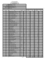
PROJECT STATUS<br />
<strong>The</strong> Program Management Team is responsible for thirty-six (36) <strong>Green</strong> <strong>Light</strong> Projects and six (6) 2002 1/2-Cent Sales Tax Projects. At the<br />
present time, twenty-four (24) projects are in “active” status ranging from corridor survey/design study through construction. <strong>The</strong> current project<br />
status is provided below in tabular form. Completed projects are considered “inactive” and projects with multiple phasing are counted only<br />
once.<br />
COMPLETED PROJECTS<br />
PROJECT DESIGN STUDY FINAL PLANS RIGHT-OF-WAY<br />
Veterans Memorial Boulevard<br />
Burbank Drive - Segment 1<br />
Burbank Drive - Segment 2<br />
North Harrell’s Ferry Road<br />
Coursey at Sherwood Intersection<br />
Foster at Government Intersection<br />
Picardy Avenue Extension<br />
Downtown Signalization<br />
Lobdell Improvements<br />
Pecue Re-Alignment at Perkins<br />
*CT1 Comite/Beaver Bayou Bridges<br />
Perkins at Stanford/Acadian<br />
S Choctaw at N Flannery Intersection<br />
Elm Grove Garden Drive<br />
*CT1 Sullivan & ICCN Railroad Bridges<br />
Brightside Lane<br />
Staring Lane Extension<br />
CT1 Paving - Florida / Sullivan Bridge<br />
Ford Street<br />
*CT2 Earthwork: Beaver Bayou Bridges 2 & 3<br />
Highland Road<br />
Jones Creek Segment 3<br />
Siegen Lane<br />
Comite Drive<br />
UTILITY<br />
RELOCATIONS<br />
CONSTRUCTION<br />
UNDER CONSTRUCTION<br />
PROJECT DESIGN STUDY FINAL PLANS RIGHT-OF-WAY UTILITY<br />
RELOCATIONS<br />
Southeast Area Group Project<br />
South Harrell’s Ferry - Seg. 1<br />
Staring Lane<br />
Stumberg Extension Phase 1<br />
*CT2 Paving - Frenchtown Rd to <strong>Green</strong>well Springs<br />
BID & CONTRACTING<br />
PROJECT DESIGN STUDY FINAL PLANS RIGHT-OF-WAY<br />
*CT1 Paving - Sullivan Bridge to Frenchtown Road<br />
*CT2 <strong>Green</strong>well Springs Intersection<br />
UTILITY<br />
RELOCATIONS<br />
CONSTRUCTION<br />
CONSTRUCTION<br />
BIDDING NEXT QUARTER<br />
PROJECT DESIGN STUDY FINAL PLANS RIGHT-OF-WAY<br />
US 61 - LA Hwy 64 Intersection<br />
PLANNING, DESIGN AND ROW ACQUISITION<br />
PROJECT DESIGN STUDY FINAL PLANS RIGHT-OF-WAY<br />
Stumberg Extension Phase 2<br />
O’Neal Lane<br />
Nicholson at Brightside/W Lee Intersection<br />
Essen Lane at I-10 Intersection<br />
Sullivan Road<br />
McHugh Road<br />
Old Hammond Hwy - Segment 2<br />
Old Hammond Hwy - Segment 1<br />
Fairchild-Badley Road<br />
Hooper Road - Blackwater to Joor<br />
Hooper Road - Joor to Sullivan<br />
Nicholson Drive - Segment 1<br />
Pecue Lane at I-10 Interchange<br />
*CT1 & CT2 refer to Central Thruway Phase 1 & Phase 2<br />
UTILITY<br />
RELOCATIONS<br />
UTILITY<br />
RELOCATIONS<br />
CONSTRUCTION<br />
CONSTRUCTION