Belcarra Draft Village Design Statement - Mayo County Council
Belcarra Draft Village Design Statement - Mayo County Council
Belcarra Draft Village Design Statement - Mayo County Council

You also want an ePaper? Increase the reach of your titles
YUMPU automatically turns print PDFs into web optimized ePapers that Google loves.
HISTORY AND<br />
VILLAGE PROFILE<br />
about 150 metres back from the road<br />
<br />
road and within its own extensive grounds.<br />
<br />
<br />
former one at Elmhall, was situated south<br />
of the Glebe House on the Ballinafad Road<br />
that heads southwest from the village.<br />
Today, it too is in ruins and all that remains<br />
is the old stone walls and its associated<br />
Graveyard.<br />
The Catholic Church was shown on the<br />
O.S Map of 1838 and the only other<br />
feature of note was the Pound, near or<br />
at the current day basketball and tennis<br />
court. A laneway ran from the Pound north<br />
and west to reconnect with the main road<br />
to Castlebar near the former ‘Arcadia<br />
Ballroom’ (near the junction that leads to<br />
<br />
to as the ‘sean bothar’ (the old road), the<br />
Old Dublin Road and the Old Dublin Coach<br />
Road. In 1838, this lane also possessed<br />
a number of dwellings, though today the<br />
lane no longer interconnects and has fewer<br />
dwellings along it. This map also reveals<br />
that a second settlement or village known<br />
as ‘New Dublin’ existed approximately<br />
500 metres to the west of Elmhall on the<br />
Castlebar Road.<br />
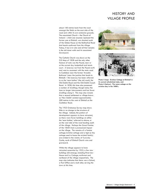
<br />
its current refurbished state, and<br />
<br />
eviction day in the 1800’s.<br />
The 1923 Ordnance Survey map shows<br />
little or no change to the structure of<br />
the village. Indeed, the pattern of<br />
development appears to have retracted,<br />
as there were fewer buildings on either<br />
the ‘sean bother,’ referred to above, or<br />
on the west side of the road leading south<br />
of the village. Perhaps the Great Famine<br />
of the 1840’s had a pronounced impact<br />
on the village. The remains of a famine<br />
cottage/eviction cottage and a tigin (a tiny<br />
cottage used to house the evicted family)<br />
are evident in the vicinity of Tyrawley<br />
Castle, north of Elmhall Church ruins and<br />
graveyard.<br />
While the village appears to have<br />
retracted somewhat by 1923, a few new<br />
buildings did emerge, including Riverview<br />
House and Ivy Cottage, northwest and<br />
northeast of the village respectively. The<br />
map also indicates that there was a School,<br />
<br />
town at this time.<br />
<strong>Belcarra</strong> • <strong>Village</strong> <strong>Design</strong> <strong>Statement</strong> • 4