Using Latitude and Longitude to Calculate Distance
Using Latitude and Longitude to Calculate Distance
Using Latitude and Longitude to Calculate Distance

You also want an ePaper? Increase the reach of your titles
YUMPU automatically turns print PDFs into web optimized ePapers that Google loves.
Math<br />
Isl<strong>and</strong> Survival<br />
Name_______________________________________________________<br />
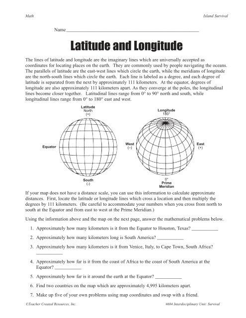
<strong>Latitude</strong> <strong>and</strong> <strong>Longitude</strong><br />
The lines of latitude <strong>and</strong> longitude are the imaginary lines which are universally accepted as<br />
coordinates for locating places on the earth. They are commonly used by people navigating the oceans.<br />
The parallels of latitude are the east-west lines which circle the earth, while the meridians of longitude<br />
are the north-south lines which circle the earth. Each line is labeled as a degree, <strong>and</strong> each degree of<br />
latitude is separated from the next by approximately 111 kilometers. At the equa<strong>to</strong>r, degrees of<br />
longitude are also approximately 111 kilometers apart. As they converge at the poles, the longitudinal<br />
lines become closer <strong>to</strong>gether. Latitudinal lines range from 0° <strong>to</strong> 90° north <strong>and</strong> south, while<br />
longitudinal lines range from 0° <strong>to</strong> 180° east <strong>and</strong> west.<br />
<strong>Latitude</strong><br />
North<br />
(+)<br />
<strong>Longitude</strong><br />
180°<br />
Equa<strong>to</strong>r<br />
West<br />
(–)<br />
East<br />
(+)<br />
South<br />
(-)<br />
0°<br />
Prime<br />
Meridian<br />
If your map does not have a distance scale, you can use this information <strong>to</strong> calculate approximate<br />
distances. First, locate the latitude or longitude lines which cross a location <strong>and</strong> then multiply the<br />
degrees by 111 kilometers. (Be careful <strong>to</strong> accommodate your numbers when you cross from north <strong>to</strong><br />
south at the Equa<strong>to</strong>r <strong>and</strong> from east <strong>to</strong> west at the Prime Meridian.)<br />
<strong>Using</strong> the information above <strong>and</strong> the map on the next page, answer the mathematical problems below.<br />
1. Approximately how many kilometers is it from the Equa<strong>to</strong>r <strong>to</strong> Hous<strong>to</strong>n, Texas? ___________<br />
2. Approximately how many kilometers long is South America? ___________<br />
3. Approximately how many kilometers is it from Venice, Italy, <strong>to</strong> Cape Town, South Africa?<br />
___________<br />
4. Approximately how far is it from the coast of Africa <strong>to</strong> the coast of South America at the<br />
Equa<strong>to</strong>r? ___________<br />
5. Approximately how far is it around the earth at the Equa<strong>to</strong>r? ___________<br />
6. Find two countries on the map which are approximately 4,995 kilometers apart.<br />
7. Make up five of your own problems using map coordinates <strong>and</strong> swap with a friend.<br />
©Teacher Created Resources, Inc.<br />
#604 Interdisciplinary Unit: Survival
Isl<strong>and</strong> Survival<br />
Math<br />
<strong>Latitude</strong> <strong>and</strong> <strong>Longitude</strong> (cont.)<br />
60°<br />
60°<br />
Arctic Circle<br />
40°<br />
40°<br />
Tropic of Cancer<br />
20°<br />
20°<br />
160°<br />
0°<br />
140° 120° 100° 80° 60° 40° 20° 0° 20° 40° 60° 80° 100° 120° 140° 160° 180°<br />
0°<br />
Equa<strong>to</strong>r<br />
Tropic of Capricon<br />
20°<br />
20°<br />
40°<br />
40°<br />
Antarctic Circle<br />
60°<br />
60°<br />
#604 Interdisciplinary Unit: Survival ©Teacher Created Resources, Inc.