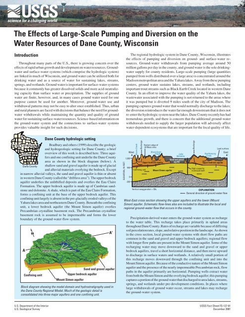
The Effects of Large-Scale Pumping and Diversion on ... - Wisconsin
The Effects of Large-Scale Pumping and Diversion on ... - Wisconsin
The Effects of Large-Scale Pumping and Diversion on ... - Wisconsin

Create successful ePaper yourself
Turn your PDF publications into a flip-book with our unique Google optimized e-Paper software.
<str<strong>on</strong>g>The</str<strong>on</strong>g> <str<strong>on</strong>g>Effects</str<strong>on</strong>g> <str<strong>on</strong>g>of</str<strong>on</strong>g> <str<strong>on</strong>g>Large</str<strong>on</strong>g>-<str<strong>on</strong>g>Scale</str<strong>on</strong>g> <str<strong>on</strong>g>Pumping</str<strong>on</strong>g> <str<strong>on</strong>g>and</str<strong>on</strong>g> <str<strong>on</strong>g>Diversi<strong>on</strong></str<strong>on</strong>g> <strong>on</strong> the<br />
Water Resources <str<strong>on</strong>g>of</str<strong>on</strong>g> Dane County, Wisc<strong>on</strong>sin<br />
Introducti<strong>on</strong><br />
Throughout many parts <str<strong>on</strong>g>of</str<strong>on</strong>g> the U.S., there is growing c<strong>on</strong>cern over the<br />
effects <str<strong>on</strong>g>of</str<strong>on</strong>g> rapid urban growth <str<strong>on</strong>g>and</str<strong>on</strong>g> development <strong>on</strong> water resources. Groundwater<br />
<str<strong>on</strong>g>and</str<strong>on</strong>g> surface-water systems (which comprise the hydrologic system)<br />
are linked in much <str<strong>on</strong>g>of</str<strong>on</strong>g> Wisc<strong>on</strong>sin, <str<strong>on</strong>g>and</str<strong>on</strong>g> ground water can be utilized both for<br />
drinking water <str<strong>on</strong>g>and</str<strong>on</strong>g> as a source <str<strong>on</strong>g>of</str<strong>on</strong>g> water for sustaining lakes, streams,<br />
springs, <str<strong>on</strong>g>and</str<strong>on</strong>g> wetl<str<strong>on</strong>g>and</str<strong>on</strong>g>s. Ground water is important for surface-water systems<br />
because it comm<strong>on</strong>ly has greater dissolved solids <str<strong>on</strong>g>and</str<strong>on</strong>g> more acid-neutralizing<br />
capacity than surface water or precipitati<strong>on</strong>. <str<strong>on</strong>g>The</str<strong>on</strong>g> supplies <str<strong>on</strong>g>of</str<strong>on</strong>g> ground<br />
water are finite, however, <str<strong>on</strong>g>and</str<strong>on</strong>g>, in many cases ground water used for <strong>on</strong>e<br />
purpose cannot be used for another. Moreover, ground-water use <str<strong>on</strong>g>and</str<strong>on</strong>g><br />
withdrawal patterns may not be easy to alter <strong>on</strong>ce established. Thus, urban<br />
<str<strong>on</strong>g>and</str<strong>on</strong>g> rural planners are faced with decisi<strong>on</strong>s that balance the need for groundwater<br />
withdrawals while maintaining the quantity <str<strong>on</strong>g>and</str<strong>on</strong>g> quality <str<strong>on</strong>g>of</str<strong>on</strong>g> ground<br />
water for sustaining surface-water resources. Science-based informati<strong>on</strong> <strong>on</strong><br />
the ground-water system <str<strong>on</strong>g>and</str<strong>on</strong>g> the c<strong>on</strong>necti<strong>on</strong>s to surface-water systems<br />
provides valuable insight for such decisi<strong>on</strong>s.<br />
<str<strong>on</strong>g>The</str<strong>on</strong>g> regi<strong>on</strong>al hydrologic system in Dane County, Wisc<strong>on</strong>sin, illustrates<br />
the effects <str<strong>on</strong>g>of</str<strong>on</strong>g> pumping <str<strong>on</strong>g>and</str<strong>on</strong>g> diversi<strong>on</strong> <strong>on</strong> ground- <str<strong>on</strong>g>and</str<strong>on</strong>g> surface-water resources.<br />
Ground-water withdrawals from pumping average around 50<br />
milli<strong>on</strong> gall<strong>on</strong>s per day in the county, <str<strong>on</strong>g>and</str<strong>on</strong>g> ground water is the sole drinkingwater<br />
supply for county residents. <str<strong>on</strong>g>Large</str<strong>on</strong>g>-scale pumping (large quantities<br />
pumped from wells distributed over a large area) is c<strong>on</strong>centrated around the<br />
Madis<strong>on</strong> metropolitan area <str<strong>on</strong>g>and</str<strong>on</strong>g> the Yahara lakes. Away from these pumping<br />
centers, ground water sustains lakes, streams, <str<strong>on</strong>g>and</str<strong>on</strong>g> wetl<str<strong>on</strong>g>and</str<strong>on</strong>g>s, including<br />
important trout streams such as Black Earth Creek located in western Dane<br />
County. In an effort to improve the water quality <str<strong>on</strong>g>of</str<strong>on</strong>g> the Yahara lakes, the<br />
wastewater associated with the pumping is not returned to the areas where<br />
it was pumped but is diverted 9 miles south <str<strong>on</strong>g>of</str<strong>on</strong>g> the city <str<strong>on</strong>g>of</str<strong>on</strong>g> Madis<strong>on</strong>. <str<strong>on</strong>g>The</str<strong>on</strong>g><br />
pumping captures ground water that would normally discharge to the lakes;<br />
the diversi<strong>on</strong> reintroduces the water far enough downstream that it does not<br />
re-enter the hydrologic system near the lakes. Dane County recently has had<br />
tremendous growth, <str<strong>on</strong>g>and</str<strong>on</strong>g> there is c<strong>on</strong>cern that the additi<strong>on</strong>al ground-water<br />
withdrawals needed to supply the larger populati<strong>on</strong> will adversely affect<br />
water-dependent ecosystems that are important for the local quality <str<strong>on</strong>g>of</str<strong>on</strong>g> life.<br />
WISCONSIN<br />
Madis<strong>on</strong><br />
Dane County<br />
Dane County hydrologic setting<br />
Bradbury <str<strong>on</strong>g>and</str<strong>on</strong>g> others (1999) describe the geologic<br />
<str<strong>on</strong>g>and</str<strong>on</strong>g> hydrogeologic setting for Dane County; a brief<br />
overview <str<strong>on</strong>g>of</str<strong>on</strong>g> this work is described here. Three aquifers<br />
<str<strong>on</strong>g>and</str<strong>on</strong>g> <strong>on</strong>e c<strong>on</strong>fining unit underlie the Dane County<br />
area as shown in the block diagram (below). A<br />
shallow s<str<strong>on</strong>g>and</str<strong>on</strong>g> <str<strong>on</strong>g>and</str<strong>on</strong>g> gravel aquifer is made up <str<strong>on</strong>g>of</str<strong>on</strong>g> glacial<br />
<str<strong>on</strong>g>and</str<strong>on</strong>g> alluvial materials overlying the bedrock. Except<br />
in narrow alluvial valleys, the s<str<strong>on</strong>g>and</str<strong>on</strong>g> <str<strong>on</strong>g>and</str<strong>on</strong>g> gravel aquifer is thin or absent<br />
in western Dane County (called the “driftless area”). <str<strong>on</strong>g>The</str<strong>on</strong>g> upper bedrock<br />
aquifer underlies the unlithified deposits <str<strong>on</strong>g>and</str<strong>on</strong>g> overlies the Eau Claire<br />
Formati<strong>on</strong>. <str<strong>on</strong>g>The</str<strong>on</strong>g> upper bedrock aquifer is made up <str<strong>on</strong>g>of</str<strong>on</strong>g> Cambrian s<str<strong>on</strong>g>and</str<strong>on</strong>g>st<strong>on</strong>e<br />
<str<strong>on</strong>g>and</str<strong>on</strong>g> dolomite. A shale, which is part <str<strong>on</strong>g>of</str<strong>on</strong>g> the Eau Claire Formati<strong>on</strong>,<br />
forms a c<strong>on</strong>fining unit at the base <str<strong>on</strong>g>of</str<strong>on</strong>g> the upper bedrock aquifer. This<br />
c<strong>on</strong>fining unit largely is absent in the pre-glacially eroded valleys <str<strong>on</strong>g>of</str<strong>on</strong>g> the<br />
Yahara lakes area <str<strong>on</strong>g>and</str<strong>on</strong>g> northeastern Dane County. Beneath the c<strong>on</strong>fining<br />
unit, a lower bedrock aquifer (the Mount Sim<strong>on</strong> aquifer) overlies<br />
Precambrian crystalline basement rock. <str<strong>on</strong>g>The</str<strong>on</strong>g> Precambrian crystalline<br />
basement rock is assumed to be impermeable <str<strong>on</strong>g>and</str<strong>on</strong>g> forms the lower<br />
boundary <str<strong>on</strong>g>of</str<strong>on</strong>g> the ground-water-flow system.<br />
A<br />
N<br />
C<strong>on</strong>fining unit<br />
Yahara lakes<br />
Upper bedrock aquifer<br />
Mount Sim<strong>on</strong> aquifer<br />
S<str<strong>on</strong>g>and</str<strong>on</strong>g> <str<strong>on</strong>g>and</str<strong>on</strong>g> gravel aquifer<br />
Block diagram showing the model domain <str<strong>on</strong>g>and</str<strong>on</strong>g> hydrostratigraphy used in<br />
the Dane County Regi<strong>on</strong>al Model. Much <str<strong>on</strong>g>of</str<strong>on</strong>g> the geologic detail is<br />
c<strong>on</strong>solidated into three major aquifers <str<strong>on</strong>g>and</str<strong>on</strong>g> <strong>on</strong>e c<strong>on</strong>fining unit.<br />
A'<br />
ELEVATION, IN FEET<br />
West<br />
A<br />
1,000<br />
500<br />
0<br />
-200<br />
Elvers Creek<br />
Recharge<br />
C<strong>on</strong>fining unit<br />
Eastern edge <str<strong>on</strong>g>of</str<strong>on</strong>g><br />
driftless area<br />
Black Earth<br />
Creek<br />
Upper bedrock aquifer<br />
Vertical exaggerati<strong>on</strong> > 50x.<br />
Mount Sim<strong>on</strong> aquifer<br />
Lake<br />
Mendota<br />
S<str<strong>on</strong>g>and</str<strong>on</strong>g> <str<strong>on</strong>g>and</str<strong>on</strong>g> gravel<br />
aquifer<br />
Precambrian crystalline rock<br />
High-capacity<br />
municipal well<br />
Koshk<strong>on</strong><strong>on</strong>g<br />
Creek<br />
L<str<strong>on</strong>g>and</str<strong>on</strong>g> surface<br />
Upper bedrock aquifer<br />
West-East cross secti<strong>on</strong> showing the upper aquifers <str<strong>on</strong>g>and</str<strong>on</strong>g> the lower (Mount<br />
Sim<strong>on</strong>) aquifer. Schematic flow-lines also are included to illustrate the local <str<strong>on</strong>g>and</str<strong>on</strong>g><br />
regi<strong>on</strong>al ground-water flow that occurs in the county.<br />
East<br />
A'<br />
Precipitati<strong>on</strong>-derived water enters the ground-water system as recharge<br />
to the water table. This recharge takes place primarily in upl<str<strong>on</strong>g>and</str<strong>on</strong>g> areas<br />
throughout Dane County. Rates <str<strong>on</strong>g>of</str<strong>on</strong>g> recharge are variable because <str<strong>on</strong>g>of</str<strong>on</strong>g> differing<br />
soil percolati<strong>on</strong> rates, slope, <str<strong>on</strong>g>and</str<strong>on</strong>g> relative positi<strong>on</strong> in the l<str<strong>on</strong>g>and</str<strong>on</strong>g>scape. As shown<br />
in the cross secti<strong>on</strong>, local ground-water systems with short flow paths are<br />
comm<strong>on</strong> in the s<str<strong>on</strong>g>and</str<strong>on</strong>g> <str<strong>on</strong>g>and</str<strong>on</strong>g> gravel <str<strong>on</strong>g>and</str<strong>on</strong>g> upper bedrock aquifers; regi<strong>on</strong>al flow<br />
with l<strong>on</strong>ger flow paths are present in the Mount Sim<strong>on</strong> aquifer. Some <str<strong>on</strong>g>of</str<strong>on</strong>g> the<br />
recharging water may move downward to the s<str<strong>on</strong>g>and</str<strong>on</strong>g> <str<strong>on</strong>g>and</str<strong>on</strong>g> gravel or upper<br />
bedrock aquifers, travel a short horiz<strong>on</strong>tal distance, <str<strong>on</strong>g>and</str<strong>on</strong>g> then move upward<br />
to discharge in surface waters <str<strong>on</strong>g>and</str<strong>on</strong>g> wetl<str<strong>on</strong>g>and</str<strong>on</strong>g>s. A relatively small porti<strong>on</strong> <str<strong>on</strong>g>of</str<strong>on</strong>g><br />
this recharge moves downward through the c<strong>on</strong>fining unit <str<strong>on</strong>g>and</str<strong>on</strong>g> into the<br />
Mount Sim<strong>on</strong> aquifer. Because <str<strong>on</strong>g>of</str<strong>on</strong>g> the c<strong>on</strong>ductive nature <str<strong>on</strong>g>of</str<strong>on</strong>g> the Mount Sim<strong>on</strong><br />
aquifer <str<strong>on</strong>g>and</str<strong>on</strong>g> the presence <str<strong>on</strong>g>of</str<strong>on</strong>g> the nearly impermeable Precambrian rock, flow<br />
paths in the aquifer primarily are horiz<strong>on</strong>tal. <str<strong>on</strong>g>Pumping</str<strong>on</strong>g> wells extract water<br />
from both the Mount Sim<strong>on</strong> <str<strong>on</strong>g>and</str<strong>on</strong>g> the overlying bedrock aquifer; this pumping<br />
captures a porti<strong>on</strong> <str<strong>on</strong>g>of</str<strong>on</strong>g> the ground water that discharged to area lakes, streams,<br />
springs, <str<strong>on</strong>g>and</str<strong>on</strong>g> wetl<str<strong>on</strong>g>and</str<strong>on</strong>g>s under pre-development c<strong>on</strong>diti<strong>on</strong>s. In places where<br />
large withdrawals <str<strong>on</strong>g>of</str<strong>on</strong>g> ground water occur, streams <str<strong>on</strong>g>and</str<strong>on</strong>g> lakes may recharge<br />
the ground-water system.<br />
Recharge<br />
EXPLANATION<br />
General directi<strong>on</strong> <str<strong>on</strong>g>of</str<strong>on</strong>g> ground-water flow<br />
U.S. Department <str<strong>on</strong>g>of</str<strong>on</strong>g> the Interior<br />
U.S. Geological Survey<br />
USGS Fact Sheet FS-127-01<br />
December 2001
In order to improve the underst<str<strong>on</strong>g>and</str<strong>on</strong>g>ing <str<strong>on</strong>g>of</str<strong>on</strong>g> the hydrologic system <str<strong>on</strong>g>and</str<strong>on</strong>g> the<br />
effects <str<strong>on</strong>g>of</str<strong>on</strong>g> increased ground-water use, a Dane County Regi<strong>on</strong>al Hydrologic<br />
Study was initiated. <str<strong>on</strong>g>The</str<strong>on</strong>g> study was a cooperative effort am<strong>on</strong>g the<br />
Dane County Regi<strong>on</strong>al Planning Commissi<strong>on</strong>, the Wisc<strong>on</strong>sin Geological<br />
<str<strong>on</strong>g>and</str<strong>on</strong>g> Nati<strong>on</strong>al History Survey, <str<strong>on</strong>g>and</str<strong>on</strong>g> the U.S. Geological Survey. <str<strong>on</strong>g>The</str<strong>on</strong>g> study<br />
included the development <str<strong>on</strong>g>of</str<strong>on</strong>g> a regi<strong>on</strong>al ground-water flow model, which<br />
helps managers make informed water-resources decisi<strong>on</strong>s <strong>on</strong> an <strong>on</strong>going<br />
basis. <str<strong>on</strong>g>The</str<strong>on</strong>g> model helped identify major areas <str<strong>on</strong>g>of</str<strong>on</strong>g> ground-water recharge <str<strong>on</strong>g>and</str<strong>on</strong>g><br />
discharge, estimate the amount <str<strong>on</strong>g>of</str<strong>on</strong>g> ground water discharging to surfacewater<br />
bodies, <str<strong>on</strong>g>and</str<strong>on</strong>g> simulate ground-water flow directi<strong>on</strong> <str<strong>on</strong>g>and</str<strong>on</strong>g> rates. Once the<br />
model was developed, it was used for assessing effects <str<strong>on</strong>g>of</str<strong>on</strong>g> future groundwater<br />
withdrawals <str<strong>on</strong>g>and</str<strong>on</strong>g> the effects <str<strong>on</strong>g>of</str<strong>on</strong>g> proposed water-management programs.<br />
<str<strong>on</strong>g>The</str<strong>on</strong>g> initial model was completed in 1995 <str<strong>on</strong>g>and</str<strong>on</strong>g> has been updated<br />
annually to incorporate current c<strong>on</strong>diti<strong>on</strong>s <str<strong>on</strong>g>and</str<strong>on</strong>g> updated modeling codes<br />
<str<strong>on</strong>g>and</str<strong>on</strong>g> procedures. <str<strong>on</strong>g>The</str<strong>on</strong>g> purpose <str<strong>on</strong>g>of</str<strong>on</strong>g> this Fact Sheet is to describe how the<br />
model was developed <str<strong>on</strong>g>and</str<strong>on</strong>g> used.<br />
How ground-water flow models work<br />
Underst<str<strong>on</strong>g>and</str<strong>on</strong>g>ing the ground-water-flow system can be difficult, so investigators<br />
comm<strong>on</strong>ly use mathematical models to simulate a simplified<br />
versi<strong>on</strong> <str<strong>on</strong>g>of</str<strong>on</strong>g> the system using computers. <str<strong>on</strong>g>The</str<strong>on</strong>g> computer code relies <strong>on</strong> two<br />
basic principles to perform simulati<strong>on</strong>s. <str<strong>on</strong>g>The</str<strong>on</strong>g> first is that water flows<br />
“downhill,” or more exactly, from high potential to low potential. <str<strong>on</strong>g>The</str<strong>on</strong>g><br />
sec<strong>on</strong>d principle is that water cannot be created or destroyed; thus, what<br />
flows into the ground-water system must either flow out or be stored.<br />
Changes in storage are identified by changes in water levels within the<br />
system. Using these principles, as well as site geology <str<strong>on</strong>g>and</str<strong>on</strong>g> locati<strong>on</strong>s <str<strong>on</strong>g>of</str<strong>on</strong>g><br />
streams <str<strong>on</strong>g>and</str<strong>on</strong>g> lakes in the area being studied, the hydrologic system is<br />
simplified <str<strong>on</strong>g>and</str<strong>on</strong>g> represented in a mathematical model. It should be noted<br />
that, whereas seemingly simple in principle <str<strong>on</strong>g>and</str<strong>on</strong>g> operati<strong>on</strong>, ground-water<br />
modeling can be complex because <str<strong>on</strong>g>of</str<strong>on</strong>g> uncertainty in important model<br />
inputs such as properties <str<strong>on</strong>g>of</str<strong>on</strong>g> the material in the subsurface <str<strong>on</strong>g>and</str<strong>on</strong>g> timing <str<strong>on</strong>g>of</str<strong>on</strong>g><br />
water additi<strong>on</strong>s <str<strong>on</strong>g>and</str<strong>on</strong>g> subtracti<strong>on</strong>s.<br />
Model calibrati<strong>on</strong><br />
<str<strong>on</strong>g>The</str<strong>on</strong>g> ground-water flow model for the Dane County area was developed<br />
using the computer program MODFLOW (McD<strong>on</strong>ald <str<strong>on</strong>g>and</str<strong>on</strong>g> Harbaugh,<br />
1988). <str<strong>on</strong>g>The</str<strong>on</strong>g> model inputs included such variables as the amount <str<strong>on</strong>g>of</str<strong>on</strong>g> rain <str<strong>on</strong>g>and</str<strong>on</strong>g><br />
snow that enters the ground-water system (that is, the amount <str<strong>on</strong>g>of</str<strong>on</strong>g> precipitati<strong>on</strong><br />
minus the amount <str<strong>on</strong>g>of</str<strong>on</strong>g> run<str<strong>on</strong>g>of</str<strong>on</strong>g>f to streams <str<strong>on</strong>g>and</str<strong>on</strong>g> the amount removed by<br />
evaporati<strong>on</strong> <str<strong>on</strong>g>and</str<strong>on</strong>g> plant uptake). In additi<strong>on</strong>, the locati<strong>on</strong>s <str<strong>on</strong>g>of</str<strong>on</strong>g> large wells,<br />
streams, <str<strong>on</strong>g>and</str<strong>on</strong>g> lakes in Dane County were entered into the model. <str<strong>on</strong>g>The</str<strong>on</strong>g> model<br />
was calibrated using 1992 pumping rates, <str<strong>on</strong>g>and</str<strong>on</strong>g> simulated ground-water<br />
levels <str<strong>on</strong>g>and</str<strong>on</strong>g> flows to or from the streams were compared to the ground-water<br />
levels <str<strong>on</strong>g>and</str<strong>on</strong>g> flows measured in the study area. Using a trial-<str<strong>on</strong>g>and</str<strong>on</strong>g>-error<br />
Important surface-water features can be affected by ground-water pumping. One<br />
such feature is the Pheasant Branch spring shown above.<br />
A<br />
B<br />
0 5 10 MILES<br />
0 5 10 KILOMETERS<br />
Fish <str<strong>on</strong>g>and</str<strong>on</strong>g> Crystal Lakes<br />
Pheasant Branch<br />
Springs<br />
Yahara lakes<br />
City <str<strong>on</strong>g>of</str<strong>on</strong>g> Madis<strong>on</strong><br />
Nine Springs<br />
area<br />
Figures 1a <str<strong>on</strong>g>and</str<strong>on</strong>g> 1b. Simulated drawdown from pre-development c<strong>on</strong>diti<strong>on</strong>s in<br />
the upper bedrock (fig. 1a) <str<strong>on</strong>g>and</str<strong>on</strong>g> Mount Sim<strong>on</strong> (fig. 1b) aquifers resulting from<br />
high-capacity pumping at typical 1992 discharge rates. <str<strong>on</strong>g>The</str<strong>on</strong>g> Yahara lakes<br />
supply water to the wells, which splits the drawdown into two distinct c<strong>on</strong>es<br />
<str<strong>on</strong>g>of</str<strong>on</strong>g> depressi<strong>on</strong>. C<strong>on</strong>tour interval is 10 feet.<br />
approach, the various model inputs were varied until model-simulated<br />
levels <str<strong>on</strong>g>and</str<strong>on</strong>g> flow approximated measured values. Measured-to-simulated<br />
ground-water levels from over 3,000 wells <str<strong>on</strong>g>and</str<strong>on</strong>g> measured-to-simulated<br />
flows in 13 streams were compared during the model calibrati<strong>on</strong> process.<br />
Model results: comparis<strong>on</strong> <str<strong>on</strong>g>of</str<strong>on</strong>g> pre-development<br />
c<strong>on</strong>diti<strong>on</strong>s to current c<strong>on</strong>diti<strong>on</strong>s<br />
Drawdown,<br />
in feet<br />
Pre-development c<strong>on</strong>diti<strong>on</strong>s were simulated by removing the pumping<br />
wells from the calibrated base model. This resulted in a representati<strong>on</strong> <str<strong>on</strong>g>of</str<strong>on</strong>g><br />
the hydrologic system before development that can be compared to current<br />
c<strong>on</strong>diti<strong>on</strong>s to assess the effects <str<strong>on</strong>g>of</str<strong>on</strong>g> pumping <strong>on</strong> water resources.<br />
As shown by c<strong>on</strong>touring the simulated drawdown (the amount <str<strong>on</strong>g>of</str<strong>on</strong>g> waterlevel<br />
decline from predevelopment c<strong>on</strong>diti<strong>on</strong>s caused by the pumping), the<br />
greatest effect <str<strong>on</strong>g>of</str<strong>on</strong>g> pumping <strong>on</strong> water levels results in the Madis<strong>on</strong> metropolitan<br />
area. Shallow <str<strong>on</strong>g>and</str<strong>on</strong>g> deep ground-water levels in the vicinity <str<strong>on</strong>g>of</str<strong>on</strong>g> Madis<strong>on</strong><br />
declined more than 60 feet (fig. 1a <str<strong>on</strong>g>and</str<strong>on</strong>g> 1b). <str<strong>on</strong>g>The</str<strong>on</strong>g> largest declines are at the<br />
centers <str<strong>on</strong>g>of</str<strong>on</strong>g> two c<strong>on</strong>es <str<strong>on</strong>g>of</str<strong>on</strong>g> depressi<strong>on</strong> that are split by the Madis<strong>on</strong> lakes.<br />
Directly adjacent to <str<strong>on</strong>g>and</str<strong>on</strong>g> beneath these lakes there is no simulated drawdown<br />
<str<strong>on</strong>g>of</str<strong>on</strong>g> the water table <str<strong>on</strong>g>and</str<strong>on</strong>g> <strong>on</strong>ly about 10 feet <str<strong>on</strong>g>of</str<strong>on</strong>g> drawdown simulated in<br />
the Mt. Sim<strong>on</strong> aquifer. Two distinct c<strong>on</strong>es <str<strong>on</strong>g>of</str<strong>on</strong>g> depressi<strong>on</strong> indicate that these<br />
lakes are important sources <str<strong>on</strong>g>of</str<strong>on</strong>g> water to the pumping wells. This result is<br />
expected because the c<strong>on</strong>fining unit is absent or thin in this area <str<strong>on</strong>g>and</str<strong>on</strong>g> the<br />
aquifers are in good hydraulic c<strong>on</strong>necti<strong>on</strong> with the lakes.<br />
It is interesting to note that prior to the large-scale pumping <str<strong>on</strong>g>and</str<strong>on</strong>g><br />
diversi<strong>on</strong> associated with development, the lakes <str<strong>on</strong>g>and</str<strong>on</strong>g> wetl<str<strong>on</strong>g>and</str<strong>on</strong>g>s within the<br />
Madis<strong>on</strong> area primarily received ground water. <str<strong>on</strong>g>The</str<strong>on</strong>g>se lakes <str<strong>on</strong>g>and</str<strong>on</strong>g> wetl<str<strong>on</strong>g>and</str<strong>on</strong>g>s<br />
primarily lose water to the ground-water system as a result <str<strong>on</strong>g>of</str<strong>on</strong>g> present-day<br />
pumping <str<strong>on</strong>g>and</str<strong>on</strong>g> diversi<strong>on</strong> (fig. 2). Moreover, the largest area where ground<br />
10<br />
20<br />
30<br />
40<br />
50<br />
60
the stream is located. In <strong>on</strong>e extreme case (W. Branch Starkweather Creek<br />
—see table 1), the stream is simulated as being dry for much <str<strong>on</strong>g>of</str<strong>on</strong>g> its length<br />
because <str<strong>on</strong>g>of</str<strong>on</strong>g> pumping <str<strong>on</strong>g>and</str<strong>on</strong>g> diversi<strong>on</strong>. In reality, the stream flows during storm<br />
events but typically is dry during n<strong>on</strong>-storm periods.<br />
Lake Mendota<br />
0 2.5 5 MILES<br />
0 2.5 5 KILOMETERS<br />
W. Branch<br />
Starkweather Creek<br />
EXPLANATION<br />
Ground-water discharge to surface water<br />
Surface-water discharge to ground water<br />
Figure 2. Model results showing the effects that pumping <str<strong>on</strong>g>and</str<strong>on</strong>g> diversi<strong>on</strong> have<br />
had <strong>on</strong> the ground-water/surface-water interacti<strong>on</strong>. During pre-development<br />
c<strong>on</strong>diti<strong>on</strong>s, ground water would have flowed to the lakes, streams, <str<strong>on</strong>g>and</str<strong>on</strong>g><br />
wetl<str<strong>on</strong>g>and</str<strong>on</strong>g>s in the modeled area. Under 1992 c<strong>on</strong>diti<strong>on</strong>s shown here, the lakes<br />
<str<strong>on</strong>g>and</str<strong>on</strong>g> streams lose water to the ground-water system (red triangles) in areas<br />
where development (<str<strong>on</strong>g>and</str<strong>on</strong>g> associated pumping <str<strong>on</strong>g>and</str<strong>on</strong>g> diversi<strong>on</strong>) are c<strong>on</strong>centrated.<br />
water currently is discharging to a lake (the northwestern side <str<strong>on</strong>g>of</str<strong>on</strong>g> Lake<br />
Mendota) is relatively undeveloped. Because ground water is the sole<br />
source <str<strong>on</strong>g>of</str<strong>on</strong>g> drinking water for the county, additi<strong>on</strong>al pumping <str<strong>on</strong>g>and</str<strong>on</strong>g> diversi<strong>on</strong><br />
associated with future development in this undeveloped area could create<br />
a c<strong>on</strong>diti<strong>on</strong> where Lake Mendota is losing water to the ground-water<br />
system <strong>on</strong> all sides. Such a change in the sources <str<strong>on</strong>g>of</str<strong>on</strong>g> water to the lake could<br />
affect the lake-water quality, food-web dynamics, <str<strong>on</strong>g>and</str<strong>on</strong>g> fish community.<br />
<str<strong>on</strong>g>The</str<strong>on</strong>g> model also can be used to compare simulated pre-development<br />
baseflows to simulated current baseflows. It is apparent that pumping has<br />
reduced baseflow in streams (see table 1). That is, the current pumping <str<strong>on</strong>g>and</str<strong>on</strong>g><br />
diversi<strong>on</strong> near the city <str<strong>on</strong>g>of</str<strong>on</strong>g> Madis<strong>on</strong> captures ground water that would<br />
c<strong>on</strong>tribute flow to these streams under pre-development c<strong>on</strong>diti<strong>on</strong>s. <str<strong>on</strong>g>The</str<strong>on</strong>g><br />
amount <str<strong>on</strong>g>of</str<strong>on</strong>g> baseflow decrease depends <strong>on</strong> how close to the pumping centers<br />
Finding the c<strong>on</strong>tributing areas for<br />
drinking-water wells<br />
Once the model is completed it can be used to trace mathematical water<br />
particles to determine where the ground water goes (if we track forward in<br />
time) or where it came from (if we track backward in time). This approach<br />
was used to simulate the area that supplies ground water to wells (called<br />
c<strong>on</strong>tributing areas). Model simulati<strong>on</strong>s indicate that, for the l<strong>on</strong>gest<br />
flowpaths, it can take many thous<str<strong>on</strong>g>and</str<strong>on</strong>g>s <str<strong>on</strong>g>of</str<strong>on</strong>g> years for ground water to move<br />
from the area where it enters the ground to where it discharges to a well,<br />
stream, or lake. Particles were tracked backwards from each municipal<br />
well located in Dane County. <str<strong>on</strong>g>The</str<strong>on</strong>g> resulting c<strong>on</strong>tributing areas (fig. 3)<br />
illustrate that the source for ground water withdrawn by municipal wells in<br />
Dane County lies entirely within the county boundaries for almost every<br />
well.<br />
Evaluating pumping scenarios<br />
<str<strong>on</strong>g>The</str<strong>on</strong>g> model also can be used to evaluate the effects <str<strong>on</strong>g>of</str<strong>on</strong>g> different pumping<br />
scenarios <strong>on</strong> ground-water availability <str<strong>on</strong>g>and</str<strong>on</strong>g> their effect <strong>on</strong> water resources.<br />
<str<strong>on</strong>g>The</str<strong>on</strong>g> model developed for Dane County dem<strong>on</strong>strated that an adequate<br />
drinking-water supply is available for Dane County if no other uses for the<br />
ground-water resources are included. Model results also dem<strong>on</strong>strated<br />
that, depending <strong>on</strong> the distributi<strong>on</strong> <str<strong>on</strong>g>and</str<strong>on</strong>g> rate <str<strong>on</strong>g>of</str<strong>on</strong>g> withdrawal <str<strong>on</strong>g>of</str<strong>on</strong>g> proposed <str<strong>on</strong>g>and</str<strong>on</strong>g><br />
existing wells, water quality may be affected, wetl<str<strong>on</strong>g>and</str<strong>on</strong>g>s may be lost, <str<strong>on</strong>g>and</str<strong>on</strong>g><br />
baseflow in streams may be reduced substantially.<br />
Two scenarios were simulated with the model based <strong>on</strong> water-use<br />
projecti<strong>on</strong>s for the year 2020 (DCRPC, 1997). <str<strong>on</strong>g>The</str<strong>on</strong>g> scenarios are: 1) the<br />
central 50 percent <str<strong>on</strong>g>of</str<strong>on</strong>g> Madis<strong>on</strong> municipal wells (inner ring <str<strong>on</strong>g>of</str<strong>on</strong>g> red dots in fig.<br />
4) provide 75 percent <str<strong>on</strong>g>of</str<strong>on</strong>g> the daily water dem<str<strong>on</strong>g>and</str<strong>on</strong>g> <str<strong>on</strong>g>and</str<strong>on</strong>g> the outer 50 percent<br />
<str<strong>on</strong>g>of</str<strong>on</strong>g> wells (outer ring <str<strong>on</strong>g>of</str<strong>on</strong>g> yellow dots in fig. 4) provide 25 percent, <str<strong>on</strong>g>and</str<strong>on</strong>g> 2) the<br />
central 50 percent <str<strong>on</strong>g>of</str<strong>on</strong>g> Madis<strong>on</strong> wells provide 25 percent <str<strong>on</strong>g>of</str<strong>on</strong>g> the daily water<br />
dem<str<strong>on</strong>g>and</str<strong>on</strong>g> <str<strong>on</strong>g>and</str<strong>on</strong>g> the outer 50 percent provide 75 percent. By providing the<br />
majority <str<strong>on</strong>g>of</str<strong>on</strong>g> water from the central wells (scenario 1), the major sources <str<strong>on</strong>g>of</str<strong>on</strong>g><br />
water for the wells are lakes <str<strong>on</strong>g>and</str<strong>on</strong>g> wetl<str<strong>on</strong>g>and</str<strong>on</strong>g>s near Madis<strong>on</strong>; baseflows in rural<br />
Table 1. Comparis<strong>on</strong> <str<strong>on</strong>g>of</str<strong>on</strong>g> pre-development <str<strong>on</strong>g>and</str<strong>on</strong>g> current c<strong>on</strong>diti<strong>on</strong>s simulated<br />
baseflows in selected Dane County, Wisc<strong>on</strong>sin streams<br />
Gaging stati<strong>on</strong> name<br />
Simulated baseflow 1 ,<br />
in cubic feet per sec<strong>on</strong>d<br />
Predevelopment<br />
Current<br />
Black Earth Creek at USGS gage above Black Earth 14.5 13.1<br />
Badger Mill Creek at STH 69 south <str<strong>on</strong>g>of</str<strong>on</strong>g> Ver<strong>on</strong>a 2.0 0.6<br />
E. Branch Starkweather Creek at Milwaukee St. 2.2 0.9<br />
Koshk<strong>on</strong><strong>on</strong>g Creek at Bailey Rd. near Sun Prairie 0.6 0.1<br />
Koshk<strong>on</strong><strong>on</strong>g Creek at Hoopen Rd. near Rockdale 36.4 33.8<br />
Maunesha River south <str<strong>on</strong>g>of</str<strong>on</strong>g> USH 151 12.3 11.9<br />
Mt. Vern<strong>on</strong> Creek at USGS Gage 2.4 2.1<br />
Murphy (Wingra) Creek at Beld St. 3.4 1.3<br />
Nine Springs at Hwy. 14 4.9 2.2<br />
Pheasant Branch Creek at USH 12 at Middlet<strong>on</strong> 2.7 1.2<br />
Six Mile Creek at Mill Rd. near Waunakee 5.0 4.3<br />
Token Creek at USH 51 13.0 10.6<br />
W. Branch Starkweather Creek at Milwaukee St. 2.8 0.0<br />
W. Branch Sugar River at STH 92 near Mt. Vern<strong>on</strong> 5.6 5.3<br />
Yahara River at Golf Course near Windsor 8.8 8.0<br />
1 Baseflow is the part <str<strong>on</strong>g>of</str<strong>on</strong>g> streamflow because <str<strong>on</strong>g>of</str<strong>on</strong>g> ground water discharging to the stream.<br />
0 5 10 MILES<br />
0 5 10 KILOMETERS<br />
EXPLANATION<br />
Well with backward particle tracing<br />
Figure 3. <str<strong>on</strong>g>The</str<strong>on</strong>g> areas that c<strong>on</strong>tribute water to the each municipal well in the<br />
county are simulated using backward particle-tracking (from the well to the<br />
recharge area) within the modeled system. <str<strong>on</strong>g>The</str<strong>on</strong>g> l<strong>on</strong>g particle paths represent<br />
a time <str<strong>on</strong>g>of</str<strong>on</strong>g> travel from the recharge area to the well <strong>on</strong> the order <str<strong>on</strong>g>of</str<strong>on</strong>g> thous<str<strong>on</strong>g>and</str<strong>on</strong>g>s<br />
<str<strong>on</strong>g>of</str<strong>on</strong>g> years.
county streams are <strong>on</strong>ly slightly affected.<br />
Scenario 2 indicates that the wells would<br />
capture water that normally would flow to<br />
area wetl<str<strong>on</strong>g>and</str<strong>on</strong>g>s <str<strong>on</strong>g>and</str<strong>on</strong>g> streams rather than removing<br />
water from the lakes. This result is<br />
dem<strong>on</strong>strated by the increased drawdown<br />
from 1992 c<strong>on</strong>diti<strong>on</strong>s for scenario 2 (fig.<br />
4b). <str<strong>on</strong>g>The</str<strong>on</strong>g> additi<strong>on</strong>al drawdown in the water<br />
table for scenario 2 is much greater than<br />
scenario 1, indicating that scenario 2 would<br />
have the greatest adverse effect <strong>on</strong> wetl<str<strong>on</strong>g>and</str<strong>on</strong>g>s<br />
<str<strong>on</strong>g>and</str<strong>on</strong>g> streams in the county. <str<strong>on</strong>g>The</str<strong>on</strong>g>se<br />
scenarios are for illustrative purposes <strong>on</strong>ly<br />
<str<strong>on</strong>g>and</str<strong>on</strong>g> do not account for the feasibility (ec<strong>on</strong>omic,<br />
political, or other c<strong>on</strong>siderati<strong>on</strong>s)<br />
<str<strong>on</strong>g>of</str<strong>on</strong>g> implementing any particular pumping<br />
strategy. Such c<strong>on</strong>siderati<strong>on</strong>s would have<br />
to also be taken into account to fully assess<br />
the practicability <str<strong>on</strong>g>of</str<strong>on</strong>g> different strategies.<br />
References<br />
Bradbury, K.R., Swans<strong>on</strong>, S.K., Krohelski, J.T.,<br />
<str<strong>on</strong>g>and</str<strong>on</strong>g> Fritz, A.K., 1999, Hydrogeology <str<strong>on</strong>g>of</str<strong>on</strong>g> Dane<br />
County, Wisc<strong>on</strong>sin: Wisc<strong>on</strong>sin Geological <str<strong>on</strong>g>and</str<strong>on</strong>g><br />
Natural History Survey Open-File Report 1999-<br />
04, 66 p.<br />
Dane County Regi<strong>on</strong>al Planning Commissi<strong>on</strong><br />
(DCRPC), 1997, <str<strong>on</strong>g>The</str<strong>on</strong>g> 1997 modeling <str<strong>on</strong>g>and</str<strong>on</strong>g> management<br />
program: DCRPC, Madis<strong>on</strong>, Wis., 24<br />
p.<br />
Krohelski, J.T., Bradbury, K.R., Hunt, R.J. <str<strong>on</strong>g>and</str<strong>on</strong>g>,<br />
Swans<strong>on</strong>, S.K., 2000, Numerical simulati<strong>on</strong> <str<strong>on</strong>g>of</str<strong>on</strong>g><br />
groundwater flow in Dane County, Wisc<strong>on</strong>sin:<br />
Wisc<strong>on</strong>sin Geological <str<strong>on</strong>g>and</str<strong>on</strong>g> Natural History<br />
Survey Bulletin 98, 31p.<br />
Krohelski, J.T., Lin, Y., Rose, W.J., <str<strong>on</strong>g>and</str<strong>on</strong>g> Hunt R.J.,<br />
2001, Simulati<strong>on</strong> <str<strong>on</strong>g>of</str<strong>on</strong>g> Fish, Mud <str<strong>on</strong>g>and</str<strong>on</strong>g> Crystal<br />
Lakes <str<strong>on</strong>g>and</str<strong>on</strong>g> the shallow ground water system <str<strong>on</strong>g>of</str<strong>on</strong>g><br />
northwestern Dane County, Wisc<strong>on</strong>sin: U.S.<br />
Geological Survey Water-Resources Investigati<strong>on</strong>s<br />
Report (in review)<br />
Hunt, R.J., <str<strong>on</strong>g>and</str<strong>on</strong>g> Steuer, J.J. 2000, Simulati<strong>on</strong> <str<strong>on</strong>g>of</str<strong>on</strong>g> the<br />
recharge area for Frederick Springs, Dane<br />
County, Wisc<strong>on</strong>sin: U.S. Geological Survey<br />
Water-Resources Investigati<strong>on</strong>s Report 00-<br />
4172, 33 p.<br />
Hunt, R.J., Steuer, J.J., Mansor, M.T.C., <str<strong>on</strong>g>and</str<strong>on</strong>g><br />
Bullen, T.D., 2001, Delineating a recharge area<br />
for a spring using numerical modeling, M<strong>on</strong>te<br />
Carlo Techniques, <str<strong>on</strong>g>and</str<strong>on</strong>g> geochemical investigati<strong>on</strong>:<br />
Ground Water v. 39, no. 5, p. 702-712.<br />
McD<strong>on</strong>ald, M.G., <str<strong>on</strong>g>and</str<strong>on</strong>g> Harbaugh, A.W., 1988, A<br />
modular three-dimensi<strong>on</strong>al finite-difference<br />
ground-water flow model: U.S. Geological Survey<br />
Techniques <str<strong>on</strong>g>of</str<strong>on</strong>g> Water-Resources Investigati<strong>on</strong>s,<br />
book 6, chap. A1, 586 p.<br />
Steuer, J.J., <str<strong>on</strong>g>and</str<strong>on</strong>g> Hunt, R.J., 2001, Use <str<strong>on</strong>g>of</str<strong>on</strong>g> a watershed-modeling approach to assess<br />
hydrologic effects <str<strong>on</strong>g>of</str<strong>on</strong>g> urbanizati<strong>on</strong>, North Fork Pheasant Branch Basin near Middlet<strong>on</strong>,<br />
Wisc<strong>on</strong>sin: U.S. Geological Survey Water-Resources Investigati<strong>on</strong>s Report 01-<br />
4113, 49 p.<br />
Informati<strong>on</strong><br />
For informati<strong>on</strong> <strong>on</strong> this study or <strong>on</strong> other USGS programs in Wisc<strong>on</strong>sin, c<strong>on</strong>tact:<br />
District Chief<br />
U.S. Geological Survey<br />
8505 Research Way<br />
Middlet<strong>on</strong>, WI 53562<br />
(608) 828-9901<br />
http://wi.water.usgs.gov/<br />
A<br />
B<br />
0 5 10 MILES<br />
0 5 10 KILOMETERS<br />
Figures 4a <str<strong>on</strong>g>and</str<strong>on</strong>g> 4b. <str<strong>on</strong>g>The</str<strong>on</strong>g> model can be used to simulate changes in the hydrologic system for a selected<br />
management scenario. In this example, the Madis<strong>on</strong> municipal wells are divided into an inner ring (red dots)<br />
<str<strong>on</strong>g>and</str<strong>on</strong>g> outer ring (yellow dots). In 4a (scenario 1) the inner ring pumps 75 percent <str<strong>on</strong>g>of</str<strong>on</strong>g> the total water pumped <str<strong>on</strong>g>and</str<strong>on</strong>g><br />
the outer ring pumps the remaining 25 percent; in 4b (scenario 2) the outer ring pumps 75 percent <str<strong>on</strong>g>of</str<strong>on</strong>g> the total<br />
water pumped <str<strong>on</strong>g>and</str<strong>on</strong>g> the inner ring pumps the remaining 25 percent. As shown, if the outer rings are required to<br />
supply 75 percent <str<strong>on</strong>g>of</str<strong>on</strong>g> the total water, there will be increased drawdown in the areas near the wells. <str<strong>on</strong>g>The</str<strong>on</strong>g>re is<br />
much less drawdown from pumping the inner ring <str<strong>on</strong>g>of</str<strong>on</strong>g> wells because the water primarily is derived from the<br />
Yahara lakes (a relatively large source <str<strong>on</strong>g>of</str<strong>on</strong>g> water).<br />
How this regi<strong>on</strong>al model has been applied to smaller site investigati<strong>on</strong>s<br />
<str<strong>on</strong>g>The</str<strong>on</strong>g> Dane County ground-water-flow model is suitable for use as a tool for regi<strong>on</strong>al water management,<br />
but because <str<strong>on</strong>g>of</str<strong>on</strong>g> its regi<strong>on</strong>al focus, the model should not be used for site-specific simulati<strong>on</strong>. However, the<br />
model provides a valuable framework within which site-specific studies can be carried out. <str<strong>on</strong>g>The</str<strong>on</strong>g> following<br />
are examples <str<strong>on</strong>g>of</str<strong>on</strong>g> <strong>on</strong>going site-specific studies that have made use <str<strong>on</strong>g>of</str<strong>on</strong>g> the Dane County model.<br />
Pheasant Branch Watershed – <str<strong>on</strong>g>The</str<strong>on</strong>g> Dane County model was used for a smaller-scale ground-water/<br />
surface-water modeling study d<strong>on</strong>e by the U.S. Geological Survey, in cooperati<strong>on</strong> with the City <str<strong>on</strong>g>of</str<strong>on</strong>g><br />
Middlet<strong>on</strong> <str<strong>on</strong>g>and</str<strong>on</strong>g> the Wisc<strong>on</strong>sin Department <str<strong>on</strong>g>of</str<strong>on</strong>g> Natural Resources. <str<strong>on</strong>g>The</str<strong>on</strong>g> study focused <strong>on</strong> the effects <str<strong>on</strong>g>of</str<strong>on</strong>g><br />
urbanizati<strong>on</strong> <strong>on</strong> streamflows <str<strong>on</strong>g>and</str<strong>on</strong>g> spring flows (Hunt <str<strong>on</strong>g>and</str<strong>on</strong>g> Steuer, 2000; Hunt <str<strong>on</strong>g>and</str<strong>on</strong>g> others, 2001; Steuer <str<strong>on</strong>g>and</str<strong>on</strong>g><br />
Hunt, 2001), <str<strong>on</strong>g>and</str<strong>on</strong>g> the models are now part <str<strong>on</strong>g>of</str<strong>on</strong>g> a large watershed-scale project c<strong>on</strong>ducted by the Wisc<strong>on</strong>sin<br />
Department <str<strong>on</strong>g>of</str<strong>on</strong>g> Natural Resources, University <str<strong>on</strong>g>of</str<strong>on</strong>g> Wisc<strong>on</strong>sin – Madis<strong>on</strong>, Wisc<strong>on</strong>sin Geological <str<strong>on</strong>g>and</str<strong>on</strong>g> Natural<br />
History Survey, <str<strong>on</strong>g>and</str<strong>on</strong>g> U.S. Geological Survey.<br />
Nine Springs Watershed – <str<strong>on</strong>g>The</str<strong>on</strong>g> Nine Springs watershed, located just south <str<strong>on</strong>g>of</str<strong>on</strong>g> the City <str<strong>on</strong>g>of</str<strong>on</strong>g> Madis<strong>on</strong> (fig.<br />
1a), c<strong>on</strong>tains an unusually large c<strong>on</strong>centrati<strong>on</strong> <str<strong>on</strong>g>of</str<strong>on</strong>g> cold-water springs <str<strong>on</strong>g>and</str<strong>on</strong>g> associated wetl<str<strong>on</strong>g>and</str<strong>on</strong>g>s. <str<strong>on</strong>g>The</str<strong>on</strong>g> Dane<br />
County model was used as a starting point for the c<strong>on</strong>structi<strong>on</strong> <str<strong>on</strong>g>of</str<strong>on</strong>g> a detailed inset model to investigate these<br />
springs <str<strong>on</strong>g>and</str<strong>on</strong>g> to determine the effects nearby l<str<strong>on</strong>g>and</str<strong>on</strong>g>-use changes may have <strong>on</strong> the springs <str<strong>on</strong>g>and</str<strong>on</strong>g> wetl<str<strong>on</strong>g>and</str<strong>on</strong>g>s<br />
(Swans<strong>on</strong>, 2001). Model simulati<strong>on</strong>s helped quantify anticipated reducti<strong>on</strong>s in spring discharge resulting<br />
from nearby ground-water withdrawals <str<strong>on</strong>g>and</str<strong>on</strong>g> simulated the l<str<strong>on</strong>g>and</str<strong>on</strong>g>-surface area c<strong>on</strong>tributing recharge to the<br />
springs. This informati<strong>on</strong> is critical for making l<str<strong>on</strong>g>and</str<strong>on</strong>g>-use decisi<strong>on</strong>s to protect the quality <str<strong>on</strong>g>and</str<strong>on</strong>g> quantity <str<strong>on</strong>g>of</str<strong>on</strong>g><br />
spring discharge.<br />
Fish <str<strong>on</strong>g>and</str<strong>on</strong>g> Crystal Lakes – Elevati<strong>on</strong> <str<strong>on</strong>g>of</str<strong>on</strong>g> the stage <str<strong>on</strong>g>of</str<strong>on</strong>g> Fish <str<strong>on</strong>g>and</str<strong>on</strong>g> Crystal Lakes, located in northwestern Dane<br />
County (fig. 1a), has increased 9 feet since 1966 <str<strong>on</strong>g>and</str<strong>on</strong>g> caused flooding <str<strong>on</strong>g>of</str<strong>on</strong>g> some near-shore residences. By<br />
using the Dane County model as a starting point, a new U.S. Geological Survey computer program that<br />
simulates lakes was coupled to a model <str<strong>on</strong>g>of</str<strong>on</strong>g> the ground-water system <str<strong>on</strong>g>and</str<strong>on</strong>g> was used to determine that<br />
increasing ground-water recharge was resp<strong>on</strong>sible for the lake-stage increase. <str<strong>on</strong>g>The</str<strong>on</strong>g> model was then used to<br />
simulate how pumping from Fish Lake would lower the stage <str<strong>on</strong>g>of</str<strong>on</strong>g> both lakes <str<strong>on</strong>g>and</str<strong>on</strong>g> how the lake stages would<br />
recover when pumping was stopped (Krohelski <str<strong>on</strong>g>and</str<strong>on</strong>g> others, 2001).<br />
Authors: R<str<strong>on</strong>g>and</str<strong>on</strong>g>all J. Hunt, Kenneth R. Bradbury, <str<strong>on</strong>g>and</str<strong>on</strong>g><br />
James T. Krohelski<br />
Printed <strong>on</strong> recycled paper<br />
EXPLANATION<br />
Madis<strong>on</strong> municipal well<br />
Other municipal well<br />
Drawdown,<br />
in feet<br />
Swans<strong>on</strong>, S.K. 2001. Hydrogeologic c<strong>on</strong>trols <strong>on</strong> spring flow near Madis<strong>on</strong>, Wisc<strong>on</strong>sin:<br />
Unpublished Ph.D. dissertati<strong>on</strong>, Dept. <str<strong>on</strong>g>of</str<strong>on</strong>g> Geology <str<strong>on</strong>g>and</str<strong>on</strong>g> Geophysics, University <str<strong>on</strong>g>of</str<strong>on</strong>g><br />
Wisc<strong>on</strong>sin–Madis<strong>on</strong>, 436 p.<br />
10<br />
15<br />
20<br />
25<br />
30<br />
35<br />
40<br />
45