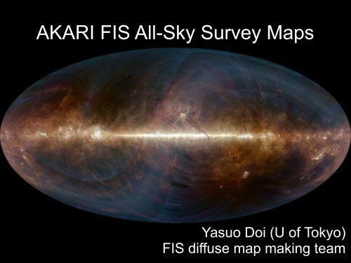
AKARI FIS All-Sky Survey Maps
AKARI FIS All-Sky Survey Maps
AKARI FIS All-Sky Survey Maps

Create successful ePaper yourself
Turn your PDF publications into a flip-book with our unique Google optimized e-Paper software.
<strong>AKARI</strong> <strong>FIS</strong> <strong>All</strong>-<strong>Sky</strong> <strong>Survey</strong> <strong>Maps</strong><br />
Yasuo Doi (U of Tokyo)<br />
<strong>FIS</strong> diffuse map making team
●<br />
●<br />
Current Status<br />
The FIR all-sky maps are under process and to be<br />
completed in 2 weeks!!<br />
Please note: current estimates in this presentation<br />
are thus TENTATIVE and need to be re-evaluated<br />
after the completion of the process.<br />
as of Dec. 9
Far-infrared all sky mapping<br />
BAND NAME N60 WIDE-S WIDE-L N160<br />
Band center [um] 65 90 140 160<br />
PSF size [arcsec]<br />
74x56 93x64 107x85 94x78<br />
Detection limit [1σ, MJy/sr] 12 2 7 4<br />
<strong>AKARI</strong> 90um+140um Cygnus<br />
<strong>AKARI</strong>
<strong>Survey</strong> coverage<br />
●<br />
●<br />
●<br />
>99% of the sky has been covered, >97-98% of them<br />
are multiply scanned<br />
Scan coverage is not spatially uniform<br />
●<br />
●<br />
stripy non-observed regions around the ecliptic plane<br />
Data quality depends upon Nscan (under investigation)<br />
Better coverage is expected with careful<br />
investigation/recovery of the data around Moon
<strong>Survey</strong> coverage<br />
black: 0 blue: 1 light blue: 2 green: 3~ red: 10~<br />
all sky map in ecliptic coordinates
Time-series data analysis<br />
Data are calibrated and cleaned for PSC<br />
Additional processes for the map are mainly on<br />
transient correction and destriping
Transient correction<br />
Frequency responses evaluated from step functions<br />
Note that significant correction has been applied<br />
down to 0.05 Hz – corresponds to >1° on the sky<br />
Good linearity has been confirmed (o^-')b
Map making example – M33 in the 140μm band:<br />
original<br />
Transient corrected<br />
1deg.<br />
destriping<br />
Transient correction+destriping
Map process/calibration<br />
Residual stripes are cleaned artificially<br />
Zodiacal light removal – to be covered by 大 坪 -talk<br />
Calibrated with <strong>AKARI</strong> slow-scan data<br />
Cross-checked with ISO/IRIS/DIRBE<br />
Contribution from many colleagues ( 池 田 君 、 小 麦 君 、<br />
…)
Characteristics of the <strong>AKARI</strong> FIR survey<br />
Extended wavelength coverage beyond 100μm<br />
BGs' color temperature, SED investigation<br />
Unprecedented spatial dynamic range of >10<br />
4<br />
From arcminute-scale to the whole sky<br />
<strong>AKARI</strong>
Higher spatial resolution than IRAS,<br />
comparable to Spitzer<br />
<strong>AKARI</strong>/SW wide<br />
<strong>AKARI</strong>/LW wide<br />
<strong>AKARI</strong> covers the whole sky with ~1’ resolution<br />
<strong>FIS</strong> 90μm <strong>FIS</strong> 140μm MIPS 160μm<br />
HPBW 38”<br />
Herschel 160μm<br />
HPBW 12”
<strong>All</strong> sky images (trial ver.)<br />
Shorter wavebands ∝ ISRF intensity<br />
Longer wavebands ∝ ISRF intensity × dust column<br />
N60<br />
WideL<br />
WideS<br />
N160
Polaris Flare (10°×10°)
Miville-Deschenes (2010)<br />
Spatial power spectra<br />
Structure down to<br />
~2'(WideL) &<br />
~1'(WideS) can be<br />
successfully traced<br />
Depends on the surface<br />
brightness<br />
∝k^-2.65±0.1<br />
SPIRE250μm in<br />
narrower region
Polaris Flare SED<br />
Model by DustEM (Compiegne 2011)
Cygnus X (5°×5°)<br />
WideS<br />
WideL
CygX SED<br />
Model by DustEM (Compiegne 2011)
ISM study with <strong>AKARI</strong>/<strong>FIS</strong> survey<br />
●<br />
●<br />
SED investigation with 4-bands<br />
●<br />
●<br />
●<br />
BGs color temperature, dust column evaluation<br />
Dust composition, evolution<br />
Combination with MIR data must be powerful!<br />
→ 左 近 -talk<br />
High spatial resolution, huge dynamic range<br />
●<br />
●<br />
From global picture of diffuse ISM/giant molecular<br />
complex down to prestellar cores!!<br />
Structure formation, phase transition, radiative<br />
transfer in denser regions, …
Data release!!<br />
●<br />
●<br />
●<br />
●<br />
●<br />
●<br />
●<br />
Scheduled before New Year break<br />
Served by C-SODA @ ISAS<br />
1.2°□ patch FITS images @ 1°grid<br />
Intensity images with Nscan,Nsample,Sigma images<br />
UI to specify the list of images in the requisite area<br />
●<br />
is that convenient enough!?<br />
Mosaic tool could be provided via PHP (not confirmed)<br />
Important : proprietary period is ONLY 6 months!!<br />
●<br />
Be ready to gobble the data
...OWARI.